ATL: ISAIAS - Post-Tropical - Discussion
Moderator: S2k Moderators
-
Evil Jeremy

- S2K Supporter

- Posts: 5463
- Age: 32
- Joined: Mon Apr 10, 2006 2:10 pm
- Location: Los Angeles, CA
Re: ATL: ISAIAS - Hurricane - Discussion
Juicy discussion from Stewart incoming...
1 likes
Frances 04 / Jeanne 04 / Katrina 05 / Wilma 05 / Fay 08 / Debby 12 / Andrea 13 / Colin 16 / Hermine 16 / Matthew 16 / Irma 17
-
eastcoastFL

- Category 5

- Posts: 3996
- Age: 44
- Joined: Thu Apr 12, 2007 12:29 pm
- Location: Palm City, FL
Re: ATL: ISAIAS - Hurricane - Discussion
jlauderdal wrote:yep, you can be under both at the same timeeastcoastFL wrote:A Hurricane Watch has been issued for portions of the Florida east
coast from north of Deerfield Beach northward to the
Volusia-Brevard County Line.
A Tropical Storm Warning has been issued for portions of the
Florida east coast from north of Ocean Reef northward to Sebastian
Inlet and for Lake Okeechobee.
So can you be under a TS Warning and Cane watch?
Yah sure looks like that’s the case here when I look at the map
0 likes
Personal Forecast Disclaimer:
The posts in this forum are NOT official forecast and should not be used as such. They are just the opinion of the poster and may or may not be backed by sound meteorological data. They are NOT endorsed by any professional institution or storm2k.org. For official information, please refer to the NHC and NWS products.
The posts in this forum are NOT official forecast and should not be used as such. They are just the opinion of the poster and may or may not be backed by sound meteorological data. They are NOT endorsed by any professional institution or storm2k.org. For official information, please refer to the NHC and NWS products.

Re: ATL: ISAIAS - Hurricane - Discussion
eastcoastFL wrote:jlauderdal wrote:yep, you can be under both at the same timeeastcoastFL wrote:A Hurricane Watch has been issued for portions of the Florida east
coast from north of Deerfield Beach northward to the
Volusia-Brevard County Line.
A Tropical Storm Warning has been issued for portions of the
Florida east coast from north of Ocean Reef northward to Sebastian
Inlet and for Lake Okeechobee.
So can you be under a TS Warning and Cane watch?
Yah sure looks like that’s the case here when I look at the map
Will be interesting to see what they do with the cone... hasn't updated yet.
0 likes

Re: ATL: ISAIAS - Hurricane - Discussion
Down to 65 kt, expected to be a strong TS at landfall in NC and a strong post-tropical cyclone by the time it gets to New England.
1 likes
Irene '11 Sandy '12 Hermine '16 5/15/2018 Derecho Fay '20 Isaias '20 Elsa '21 Henri '21 Ida '21
I am only a meteorology enthusiast who knows a decent amount about tropical cyclones. Look to the professional mets, the NHC, or your local weather office for the best information.
I am only a meteorology enthusiast who knows a decent amount about tropical cyclones. Look to the professional mets, the NHC, or your local weather office for the best information.

-
DestinHurricane

- Category 4

- Posts: 935
- Joined: Tue May 01, 2018 8:05 am
- Location: New York, NY
Re: ATL: ISAIAS - Hurricane - Discussion
lhpfish wrote:eastcoastFL wrote:jlauderdal wrote:yep, you can be under both at the same time
Yah sure looks like that’s the case here when I look at the map
Will be interesting to see what they do with the cone... hasn't updated yet.
updated for me. Barely nudged it west.
Last edited by DestinHurricane on Fri Jul 31, 2020 9:57 am, edited 1 time in total.
0 likes
Michael 2018

Re: ATL: ISAIAS - Hurricane - Discussion
Evil Jeremy wrote:HURRICANE WATCH ISSUED FOR PORTIONS OF THE FLORIDA EAST COAST
A Hurricane Watch has been issued for portions of the Florida east
coast from north of Deerfield Beach northward to the
Volusia-Brevard County Line.
A Tropical Storm Warning has been issued for portions of the
Florida east coast from north of Ocean Reef northward to Sebastian
Inlet and for Lake Okeechobee.
Wow, looks like FL is in play again, any 'good news' from earlier was short lived, and Miami north to Daytona are not out of the woods yet! No bueno, gonna be a close call. Hopefully Southeast FL lucks out the way they did with Matthew.
2 likes
Georges '98, Irene '99, Frances '04, Jeanne '04, Katrina '05, Wilma '05, Gustav '08, Isaac '12, Matthew '16, Florence '18, Michael '18, Ian '22
-
eastcoastFL
- Category 5
- Posts: 3996
- Age: 44
- Joined: Thu Apr 12, 2007 12:29 pm
- Location: Palm City, FL
Re: ATL: ISAIAS - Hurricane - Discussion
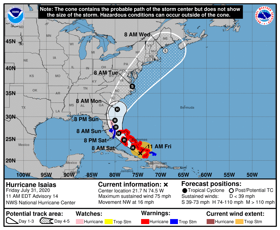
The nhc does not seem to buy into any weakening in the near term
Data from the reconnaissance aircraft indicate that maximum
sustained winds are near 75 mph (120 km/h) with higher gusts. Some
strengthening is possible today and tonight, and Isaias is expected
to remain a hurricane for the next few days.
Hurricane-force winds extend outward up to 35 miles (55 km) from the
center and tropical-storm-force winds extend outward up to 205 miles
(335 km).
Reports from the reconnaissance aircraft indicate that the minimum
central pressure is 992 mb (29.30 inches).
1 likes
Personal Forecast Disclaimer:
The posts in this forum are NOT official forecast and should not be used as such. They are just the opinion of the poster and may or may not be backed by sound meteorological data. They are NOT endorsed by any professional institution or storm2k.org. For official information, please refer to the NHC and NWS products.
The posts in this forum are NOT official forecast and should not be used as such. They are just the opinion of the poster and may or may not be backed by sound meteorological data. They are NOT endorsed by any professional institution or storm2k.org. For official information, please refer to the NHC and NWS products.

Re: ATL: ISAIAS - Hurricane - Discussion
Inflow clearly improving from south and west. Forced surface convergence compliments of the East Cuban terrain should allow Isaias to once again puff out his chest today. Nonetheless, the western semicircle of the storm has been degraded and it will be interesting to see if the storm can better expand the right-leaning upper anticyclone over itself. The type of convective bursting taking place over center would certainly go a long way to do that. Just no current banded structure at all so it has a way to go prior to expanding into much of a larger threat (especially on it's western semicircle).
4 likes
Andy D
(For official information, please refer to the NHC and NWS products.)
(For official information, please refer to the NHC and NWS products.)
Re: ATL: ISAIAS - Hurricane - Discussion
Key points from discussion
Dry
downslope air coming off of Hispaniola wrapped into the center,
eroding the inner-core convection somewhat. However, a surge of
moist southwesterly inflow moving through the Windward Passage now
appears to be fueling the recent increase in convection. The
upper-level outflow has improved somewhat in the western
semicircle but still remains restricted due to some modest
southwesterly vertical wind shear.
The timing and strength of this
trough will determine how far west Isaias moves before the hurricane
turns northward. The 06Z UKMET and and GFS have shifted westward,
closer to the Florida coast, which is similar to the westward shift
seen in the 00Z ECMWF model fields
Although some slight weakening has occurred, radar data from the
aircraft and the Bahamas radar indicate about a 60-percent
eyewall has formed in the northeastern semicircle, which is an
indication that the cyclone is trying to reorganize. As a result,
strengthening is still expected during the next day or so,
especially tonight and Saturday morning during the convective
maximum period when the hurricane will be moving over the Gulf
Stream where SSTs are 30C or warmer and while the vertical remains
reasonably low. Increasing southwesterly shear could cause a gradual
decrease in intensity over the weekend.
The posts in this forum are NOT official forecasts and should not be used as such. They are just the opinion of the poster and may or may not be backed by sound meteorological data. They are NOT endorsed by any professional institution or STORM2K. For official information, please refer to products from the NHC and NWS.
Last edited by caneseddy on Fri Jul 31, 2020 10:08 am, edited 2 times in total.
5 likes
-
eastcoastFL
- Category 5
- Posts: 3996
- Age: 44
- Joined: Thu Apr 12, 2007 12:29 pm
- Location: Palm City, FL
Re: ATL: ISAIAS - Hurricane - Discussion
I didn’t see this part coming
Although some slight weakening has occurred, radar data from the
aircraft and the Bahamas radar indicate about a 60-percent
eyewall has formed in the northeastern semicircle, which is an
indication that the cyclone is trying to reorganize. As a result,
strengthening is still expected during the next day or so,
especially tonight and Saturday morning during the convective
maximum period when the hurricane will be moving over the Gulf
Stream where SSTs are 30C or warmer and while the vertical remains
reasonably low. Increasing southwesterly shear could cause a gradual
decrease in intensity over the weekend. The new official intensity
forecast is similar to the previous advisory, and is a little above
the available model guidance out of respect for continuity.
3 likes
Personal Forecast Disclaimer:
The posts in this forum are NOT official forecast and should not be used as such. They are just the opinion of the poster and may or may not be backed by sound meteorological data. They are NOT endorsed by any professional institution or storm2k.org. For official information, please refer to the NHC and NWS products.
The posts in this forum are NOT official forecast and should not be used as such. They are just the opinion of the poster and may or may not be backed by sound meteorological data. They are NOT endorsed by any professional institution or storm2k.org. For official information, please refer to the NHC and NWS products.
-
Evil Jeremy
- S2K Supporter
- Posts: 5463
- Age: 32
- Joined: Mon Apr 10, 2006 2:10 pm
- Location: Los Angeles, CA
Re: ATL: ISAIAS - Hurricane - Discussion
The 11AM position is .1 north and .6 west of where NHC forecast it to be at this point in the 11pm advisory last night.
3 likes
Frances 04 / Jeanne 04 / Katrina 05 / Wilma 05 / Fay 08 / Debby 12 / Andrea 13 / Colin 16 / Hermine 16 / Matthew 16 / Irma 17
-
Aric Dunn
- Category 5
- Posts: 21238
- Age: 43
- Joined: Sun Sep 19, 2004 9:58 pm
- Location: Ready for the Chase.
- Contact:
Re: ATL: ISAIAS - Hurricane - Discussion
Evil Jeremy wrote:The 11AM position is .1 north and .6 west of where NHC forecast it to be at this point in the 11pm advisory last night.
yep keeps staying the far left side of the cone. sometimes out of the cone..
0 likes
Note: If I make a post that is brief. Please refer back to previous posts for the analysis or reasoning. I do not re-write/qoute what my initial post said each time.
If there is nothing before... then just ask
Space & Atmospheric Physicist, Embry-Riddle Aeronautical University,
I believe the sky is falling...
If there is nothing before... then just ask
Space & Atmospheric Physicist, Embry-Riddle Aeronautical University,
I believe the sky is falling...

Re: ATL: ISAIAS - Hurricane - Discussion
Starting to look better on radar than earlier this morning.

1 likes
-
DestinHurricane
- Category 4
- Posts: 935
- Joined: Tue May 01, 2018 8:05 am
- Location: New York, NY
Re: ATL: ISAIAS - Hurricane - Discussion
Aric Dunn wrote:Evil Jeremy wrote:The 11AM position is .1 north and .6 west of where NHC forecast it to be at this point in the 11pm advisory last night.
yep keeps staying the far left side of the cone. sometimes out of the cone..
It's going to have to turn hard NW in the next few hours or else Florida may be in for a surprise.
4 likes
Michael 2018

Re: ATL: ISAIAS - Hurricane - Discussion
Looks like that western hot tower did the trick.
Nice CDO building from it.
This is the second big-ass tower to fire it off.
Afternoon convection over Cuba is going to be the next thing to watch for if it can give it another snort
Nice CDO building from it.
This is the second big-ass tower to fire it off.
Afternoon convection over Cuba is going to be the next thing to watch for if it can give it another snort
3 likes
-
Blown Away

- S2K Supporter
- Posts: 10253
- Joined: Wed May 26, 2004 6:17 am
Re: ATL: ISAIAS - Hurricane - Discussion
Aric Dunn wrote:Evil Jeremy wrote:The 11AM position is .1 north and .6 west of where NHC forecast it to be at this point in the 11pm advisory last night.
yep keeps staying the far left side of the cone. sometimes out of the cone..
For Florida, model watching over it's satellite time.
8 likes
Hurricane Eye Experience: David 79, Irene 99, Frances 04, Jeanne 04, Wilma 05… Hurricane Brush Experience: Andrew 92, Erin 95, Floyd 99, Matthew 16, Irma 17, Ian 22, Nicole 22…
-
WilmingtonSandbar
- S2K Supporter
- Posts: 505
- Joined: Sun Aug 29, 2010 12:11 pm
- Location: Southport, NC
Re: ATL: ISAIAS - Hurricane - Discussion
gatorcane wrote:I happen to think Isaias is organizing again or on the verge of. Note the deep high tower near the center. Also notice the outer band to the north starting to wrap more to the west and south around. Note too the shear isn’t that bad really. The high clouds over Cuba are only moving modestly north. With a vigorous center and boiling SSTs, expect strengthening:
https://www.tropicaltidbits.com/sat/sat ... product=ir
How much could the spine of Cuba effect inflow into Izzy?
0 likes
Diana X2 (look it up), Bertha, Fran, Bonnie, Floyd, Dennis, Charley, Ophelia, Ernesto, Irene, Matthew, And Florence
-
eastcoastFL
- Category 5
- Posts: 3996
- Age: 44
- Joined: Thu Apr 12, 2007 12:29 pm
- Location: Palm City, FL
Re: ATL: ISAIAS - Hurricane - Discussion
Blown Away wrote:Aric Dunn wrote:Evil Jeremy wrote:The 11AM position is .1 north and .6 west of where NHC forecast it to be at this point in the 11pm advisory last night.
yep keeps staying the far left side of the cone. sometimes out of the cone..
For Florida, model watching over it's satellite time.
Yup and pretty soon radar. I hope I don’t have to make a last minute run and put up shutters...
1 likes
Personal Forecast Disclaimer:
The posts in this forum are NOT official forecast and should not be used as such. They are just the opinion of the poster and may or may not be backed by sound meteorological data. They are NOT endorsed by any professional institution or storm2k.org. For official information, please refer to the NHC and NWS products.
The posts in this forum are NOT official forecast and should not be used as such. They are just the opinion of the poster and may or may not be backed by sound meteorological data. They are NOT endorsed by any professional institution or storm2k.org. For official information, please refer to the NHC and NWS products.
-
Kiko Snowe

- Tropical Low

- Posts: 12
- Joined: Wed May 27, 2020 10:11 pm
Re: ATL: ISAIAS - Hurricane - Discussion
I don't imagine Cuba having a very big effect on Isaias at all, honestly. Gonna be a storm to watch.
0 likes
Who is online
Users browsing this forum: No registered users and 26 guests