ATL: NANA - Remnants - Discussion
Moderator: S2k Moderators

Re: ATL: NANA - Tropical Storm - Discussion
Tiny storm like Beryl
0 likes
Very useful information on the Dvorak Technique --
https://severe.worldweather.wmo.int/TCF ... kBeven.pdf
https://severe.worldweather.wmo.int/TCF ... kBeven.pdf
-
EquusStorm
- Category 5

- Posts: 1649
- Age: 35
- Joined: Thu Nov 07, 2013 1:04 pm
- Location: Jasper, AL
- Contact:
Re: ATL: NANA - Tropical Storm - Discussion
Welp... essentially, here's your Iris analog


3 likes
Colors of lost purpose on the canvas of irrelevance
Not a meteorologist, in fact more of an idiot than anything. You should probably check with the NHC or a local NWS office for official information.
Not a meteorologist, in fact more of an idiot than anything. You should probably check with the NHC or a local NWS office for official information.

Re: ATL: NANA - Tropical Storm - Discussion
Highteeld wrote:Tiny storm like Beryl
Or more recently Marco.
0 likes
-
shiny-pebble
- Category 1

- Posts: 299
- Joined: Thu Jul 05, 2018 1:38 pm
Re: ATL: NANA - Tropical Storm - Discussion
While I do think this has a good shot at H status I don't think Iris is the best analog for intensity. Iris was a hurricane when it was in this location.
Sent from my SM-G970U using Tapatalk
Sent from my SM-G970U using Tapatalk
0 likes
Not an meteorologist! Just someone who is interested in weather. Please refer to the NHC and local weather officials to make decisions.
-Jack
-Jack
-
EquusStorm
- Category 5
- Posts: 1649
- Age: 35
- Joined: Thu Nov 07, 2013 1:04 pm
- Location: Jasper, AL
- Contact:
Re: ATL: NANA - Tropical Storm - Discussion
Definitely not as intense as Iris, but similar size, forward motion, and track. Probably will be a hurricane soon though.
0 likes
Colors of lost purpose on the canvas of irrelevance
Not a meteorologist, in fact more of an idiot than anything. You should probably check with the NHC or a local NWS office for official information.
Not a meteorologist, in fact more of an idiot than anything. You should probably check with the NHC or a local NWS office for official information.
-
Aric Dunn
- Category 5
- Posts: 21238
- Age: 43
- Joined: Sun Sep 19, 2004 9:58 pm
- Location: Ready for the Chase.
- Contact:
Re: ATL: NANA - Tropical Storm - Discussion
Recon doing some circles in the eye.. briefly crossed the north quad with a 58kt FL.
heading to east quad now ..

heading to east quad now ..
0 likes
Note: If I make a post that is brief. Please refer back to previous posts for the analysis or reasoning. I do not re-write/qoute what my initial post said each time.
If there is nothing before... then just ask
Space & Atmospheric Physicist, Embry-Riddle Aeronautical University,
I believe the sky is falling...
If there is nothing before... then just ask
Space & Atmospheric Physicist, Embry-Riddle Aeronautical University,
I believe the sky is falling...

Re: ATL: NANA - Tropical Storm - Discussion
EquusStorm wrote:Welp... essentially, here's your Iris analog
https://cdn.discordapp.com/attachments/750340898310848603/750392835949330512/GOES16102020245FogLvs.jpg https://cdn.discordapp.com/attachments/750340898310848603/750392836146462751/1280px-Iris_2001-10-08_1645Z.jpg
https://upload.wikimedia.org/wikipedia/commons/thumb/0/04/Iris_2001_track.png/1280px-Iris_2001_track.png
I was thinking Nana could be like Iris. Both are exceptionally tiny and compact systems taking a similar path, but the main difference is that Iris was already a hurricane in the middle of the Caribbean before blowing up into a Cat 4.
0 likes
Irene '11 Sandy '12 Hermine '16 5/15/2018 Derecho Fay '20 Isaias '20 Elsa '21 Henri '21 Ida '21
I am only a meteorology enthusiast who knows a decent amount about tropical cyclones. Look to the professional mets, the NHC, or your local weather office for the best information.
I am only a meteorology enthusiast who knows a decent amount about tropical cyclones. Look to the professional mets, the NHC, or your local weather office for the best information.
-
Argcane
- Tropical Low

- Posts: 24
- Age: 26
- Joined: Wed Aug 19, 2020 12:52 pm
- Location: Patagonia/Argentina
Re: ATL: NANA - Tropical Storm - Discussion
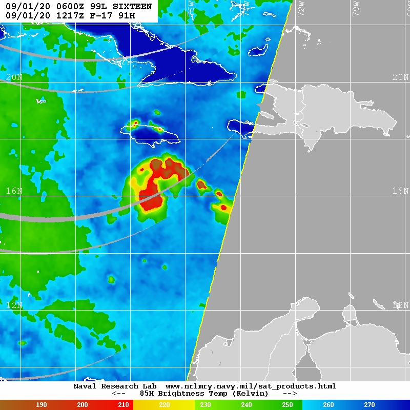
Well, that escalated quickly. Looks like it is developing an eye 
2 likes
Re: ATL: NANA - Tropical Storm - Discussion

0 likes
Very useful information on the Dvorak Technique --
https://severe.worldweather.wmo.int/TCF ... kBeven.pdf
https://severe.worldweather.wmo.int/TCF ... kBeven.pdf
-
Hypercane_Kyle

- Category 5
- Posts: 3465
- Joined: Sat Mar 07, 2015 7:58 pm
- Location: Cape Canaveral, FL
Re: ATL: NANA - Tropical Storm - Discussion
If this storm already has an eye as reported by the Recon VDM, then this may be a much more serious threat than we anticipated.
1 likes
My posts are my own personal opinion, defer to the National Hurricane Center (NHC) and other NOAA products for decision making during hurricane season.
-
tropicwatch

- Category 5
- Posts: 3426
- Age: 62
- Joined: Sat Jun 02, 2007 10:01 am
- Location: The Villages, Florida
- Contact:
Re: ATL: NANA - Tropical Storm - Discussion
Hope the high in the gulf holds steady the next two days.
0 likes
Tropicwatch
Agnes 72', Eloise 75, Elena 85', Kate 85', Charley 86', Florence 88', Beryl 94', Dean 95', Erin 95', Opal 95', Earl 98', Georges 98', Ivan 2004', Arlene 2005', Dennis 2005', Ida 2009' Debby 2012' Irma 2017' Michael 2018'
Agnes 72', Eloise 75, Elena 85', Kate 85', Charley 86', Florence 88', Beryl 94', Dean 95', Erin 95', Opal 95', Earl 98', Georges 98', Ivan 2004', Arlene 2005', Dennis 2005', Ida 2009' Debby 2012' Irma 2017' Michael 2018'
-
ColdMiser123

- Professional-Met

- Posts: 905
- Age: 29
- Joined: Mon Sep 26, 2016 3:26 pm
- Location: Northeast US
Re: ATL: NANA - Tropical Storm - Discussion
58 KT FL wind at around 1500 meters supports 48 KT at the surface, definitely closer to being a 50 KT storm than a 45 KT storm at this point.
0 likes
B.S., M.S., Meteorology & Atmospheric Science
Re: ATL: NANA - Tropical Storm - Discussion
Nice OHC in its path.

0 likes
Irene '11 Sandy '12 Hermine '16 5/15/2018 Derecho Fay '20 Isaias '20 Elsa '21 Henri '21 Ida '21
I am only a meteorology enthusiast who knows a decent amount about tropical cyclones. Look to the professional mets, the NHC, or your local weather office for the best information.
I am only a meteorology enthusiast who knows a decent amount about tropical cyclones. Look to the professional mets, the NHC, or your local weather office for the best information.
-
EquusStorm
- Category 5
- Posts: 1649
- Age: 35
- Joined: Thu Nov 07, 2013 1:04 pm
- Location: Jasper, AL
- Contact:
Re: ATL: NANA - Tropical Storm - Discussion
Similar track as Francelia 69, Fifi 74, Greta 78, and of course Iris. Interestingly, all of those storms survived into the East Pacific as at least remnants; probably only Francelia completely lost its identity but still contributed to the development of a hurricane there. We'll see if it gets strong enough to survive the passage; some rough terrain in there.
Last edited by EquusStorm on Tue Sep 01, 2020 11:56 am, edited 1 time in total.
1 likes
Colors of lost purpose on the canvas of irrelevance
Not a meteorologist, in fact more of an idiot than anything. You should probably check with the NHC or a local NWS office for official information.
Not a meteorologist, in fact more of an idiot than anything. You should probably check with the NHC or a local NWS office for official information.
-
Hypercane_Kyle
- Category 5
- Posts: 3465
- Joined: Sat Mar 07, 2015 7:58 pm
- Location: Cape Canaveral, FL
Re: ATL: NANA - Tropical Storm - Discussion
Special advisory now explicitly calling for a hurricane landfall.
FORECAST VALID 02/0000Z 16.6N 79.5W
MAX WIND 50 KT...GUSTS 60 KT.
50 KT... 20NE 0SE 0SW 0NW.
34 KT... 70NE 0SE 0SW 70NW.
FORECAST VALID 02/1200Z 16.7N 82.3W
MAX WIND 55 KT...GUSTS 65 KT.
50 KT... 30NE 20SE 0SW 20NW.
34 KT... 70NE 40SE 0SW 70NW.
FORECAST VALID 03/0000Z 16.8N 85.1W
MAX WIND 60 KT...GUSTS 75 KT.
50 KT... 30NE 20SE 0SW 20NW.
34 KT... 70NE 40SE 0SW 70NW.
FORECAST VALID 03/1200Z 16.8N 87.4W
MAX WIND 65 KT...GUSTS 80 KT.
64 KT... 15NE 0SE 0SW 15NW.
50 KT... 30NE 20SE 0SW 30NW.
34 KT... 70NE 50SE 30SW 70NW.
FORECAST VALID 04/0000Z 16.5N 89.6W...INLAND
MAX WIND 30 KT...GUSTS 40 KT.
FORECAST VALID 04/1200Z 15.7N 91.7W...POST-TROP/REMNT LOW
MAX WIND 15 KT...GUSTS 20 KT.
EXTENDED OUTLOOK. NOTE...ERRORS FOR TRACK HAVE AVERAGED NEAR 150 NM
ON DAY 4 AND 175 NM ON DAY 5...AND FOR INTENSITY NEAR 15 KT EACH DAY
OUTLOOK VALID 05/1200Z...DISSIPATED
REQUEST FOR 3 HOURLY SHIP REPORTS WITHIN 300 MILES OF 16.6N 77.9W
INTERMEDIATE PUBLIC ADVISORY...WTNT31 KNHC/MIATCPAT1...AT 01/1800Z
NEXT ADVISORY AT 01/2100Z
1 likes
My posts are my own personal opinion, defer to the National Hurricane Center (NHC) and other NOAA products for decision making during hurricane season.
-
Aric Dunn
- Category 5
- Posts: 21238
- Age: 43
- Joined: Sun Sep 19, 2004 9:58 pm
- Location: Ready for the Chase.
- Contact:
Re: ATL: NANA - Tropical Storm - Discussion
From the amount of unflagged SFMR in multiple quads of 53 to 56 kts. and FL of 58+
55kts is reasonable.
55kts is reasonable.
0 likes
Note: If I make a post that is brief. Please refer back to previous posts for the analysis or reasoning. I do not re-write/qoute what my initial post said each time.
If there is nothing before... then just ask
Space & Atmospheric Physicist, Embry-Riddle Aeronautical University,
I believe the sky is falling...
If there is nothing before... then just ask
Space & Atmospheric Physicist, Embry-Riddle Aeronautical University,
I believe the sky is falling...
Re: ATL: NANA - Tropical Storm - Discussion
If Nana rapidly intensifies into a midget major like Iris, this will be one of the biggest model forecast busts in years. Not even the CMC or ICON, which have done better sniffing out genesis this year, have shown anything significant in the near term.
6 likes
Irene '11 Sandy '12 Hermine '16 5/15/2018 Derecho Fay '20 Isaias '20 Elsa '21 Henri '21 Ida '21
I am only a meteorology enthusiast who knows a decent amount about tropical cyclones. Look to the professional mets, the NHC, or your local weather office for the best information.
I am only a meteorology enthusiast who knows a decent amount about tropical cyclones. Look to the professional mets, the NHC, or your local weather office for the best information.
-
TallyTracker
- Category 2

- Posts: 787
- Joined: Thu Oct 11, 2018 2:46 pm
Re: ATL: NANA - Tropical Storm - Discussion
The CMC did a great job catching this one earlier than most models! ICON model also had a solid storm around this location as well several days ago.
2 likes
Fran '96, Georges '98, Gordon '00, Gabrielle '01, Charley '04, Frances '04, Jeanne '04, Barry '07, Fay '08, Debby '12, Matthew '16, Emily '17, Irma '17, Michael ‘18, Elsa ‘21, Fred ‘21, Mindy ‘21, Nicole ‘22, Idalia ‘23, Debby ‘24, Helene ‘24
-
cheezyWXguy

- Category 5
- Posts: 6282
- Joined: Mon Feb 13, 2006 12:29 am
- Location: Dallas, TX
Re: ATL: NANA - Tropical Storm - Discussion
aspen wrote:If Nana rapidly intensifies into a midget major like Iris, this will be one of the biggest model forecast busts in years. Not even the CMC or ICON, which have done better sniffing out genesis this year, have shown anything significant in the near term.
Yep, I think the closest we got was the icon showing a cat2 approaching Jamaica when this was like a week out
0 likes
-
EquusStorm
- Category 5
- Posts: 1649
- Age: 35
- Joined: Thu Nov 07, 2013 1:04 pm
- Location: Jasper, AL
- Contact:
Re: ATL: NANA - Tropical Storm - Discussion
And Nana developing into a probable hurricane without even SHORT term global model support is yet another reason why we don't cancel the rest of the season based on those same models' LONG term relative quiescence.
10 likes
Colors of lost purpose on the canvas of irrelevance
Not a meteorologist, in fact more of an idiot than anything. You should probably check with the NHC or a local NWS office for official information.
Not a meteorologist, in fact more of an idiot than anything. You should probably check with the NHC or a local NWS office for official information.
Who is online
Users browsing this forum: No registered users and 23 guests