ATL: LAURA - Post-Tropical - Discussion

Moderator: S2k Moderators

Message
Author
Shell Mound
Category 5
Category 5
Posts: 2434
Age: 32
Joined: Thu Sep 07, 2017 3:39 pm
Location: St. Petersburg, FL → Scandinavia

Re: ATL: LAURA - Tropical Storm - Discussion

#3941 Postby Shell Mound » Tue Aug 25, 2020 6:01 am


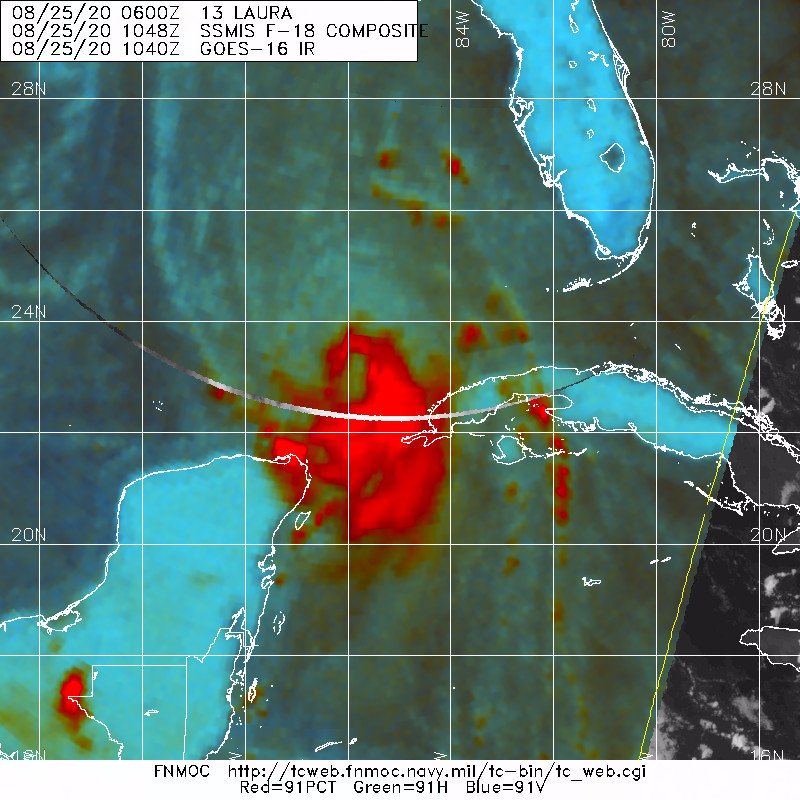
Note the classic “foetus” or “fist” with expanding convective growth on the northern side of the circulation. This typically presages rapid deepening. If I recall correctly, Katrina (2005) featured a very similar convective pattern as it headed west-southwestward near the Florida Keys. Given the fact that the centre has been consistently trending southwest of the guidance, this increases the risk of a much more powerful system farther west over relatively higher TCHP/OHC in the Gulf of Mexico. One other factor to mention is the interaction of very subtle features such as the attenuated Rossby wave and the position of the ridge axis relative to Laura as the prospective hurricane nears Texas; this could result in critical, last-minute shifts that would significantly alter impacts to local areas. At this point, I still think that landfall is more likely to occur between Gilchrist and Sabine Pass, TX, than to the west of Galveston Bay.
4 likes   
CVW / MiamiensisWx / Shell Mound
The posts in this forum are NOT official forecasts and should not be used as such. They are just the opinion of the poster and may or may not be backed by sound meteorological data. They are NOT endorsed by any professional institution or STORM2K. For official information, please refer to products from the NHC and NWS.

User avatar
galvbay
Tropical Storm
Tropical Storm
Posts: 174
Joined: Mon Oct 14, 2002 8:29 pm
Location: Fort Anahuac, TX

Re: ATL: LAURA - Tropical Storm - Discussion

#3942 Postby galvbay » Tue Aug 25, 2020 6:01 am

dantonlsu wrote:
galvbay wrote:
dantonlsu wrote:Not liking the shift west in the models & the new forecast, especially parts of the discussion.

Thinking If I'm gonna bug out of Seabrook, will need to be by noon to avoid all the mayham.


We are across the bay from you in Chambers County. Good luck with your decisions. gb


What have been your thoughts?


We are at 18’ asl. Did not get water during Ike or Harvey. Prepped to the max. Do not want to be involved with the evac fiasco...staying as of now. Lived on TX gc since 1955.
1 likes   

User avatar
aspen
Category 5
Category 5
Posts: 8820
Joined: Sat Oct 12, 2019 7:10 pm
Location: Connecticut, USA

Re: ATL: LAURA - Tropical Storm - Discussion

#3943 Postby aspen » Tue Aug 25, 2020 6:02 am

supercane4867 wrote:We may have Hurricane Laura.

It’s 60 kt at the very least. Once it does become a hurricane, it’ll be the first ever Hurricane Laura.
2 likes   
Irene '11 Sandy '12 Hermine '16 5/15/2018 Derecho Fay '20 Isaias '20 Elsa '21 Henri '21 Ida '21

I am only a meteorology enthusiast who knows a decent amount about tropical cyclones. Look to the professional mets, the NHC, or your local weather office for the best information.

User avatar
Kingarabian
S2K Supporter
S2K Supporter
Posts: 16024
Joined: Sat Aug 08, 2009 3:06 am
Location: Honolulu, Hawaii

Re: ATL: LAURA - Tropical Storm - Discussion

#3944 Postby Kingarabian » Tue Aug 25, 2020 6:02 am

CDO is in place now and its expanding. Also notice the -80C cloud tops are starting to go off near the center:
Image
6 likes   
RIP Kobe Bryant

supercane4867
Category 5
Category 5
Posts: 4966
Joined: Wed Nov 14, 2012 10:43 am

Re: ATL: LAURA - Tropical Storm - Discussion

#3945 Postby supercane4867 » Tue Aug 25, 2020 6:06 am

The strongest winds will be in the NE quadrant where the pressure gradient with the building ridge to its NE is the steepest.
4 likes   

User avatar
Kingarabian
S2K Supporter
S2K Supporter
Posts: 16024
Joined: Sat Aug 08, 2009 3:06 am
Location: Honolulu, Hawaii

Re: ATL: LAURA - Tropical Storm - Discussion

#3946 Postby Kingarabian » Tue Aug 25, 2020 6:07 am

supercane4867 wrote:The strongest winds will be in the NE quadrant where the pressure gradient with the building ridge to its NE is the greatest.

Yeah I think they'll find hurricane winds on that pass.
0 likes   
RIP Kobe Bryant

Do_For_Love
Category 1
Category 1
Posts: 271
Age: 35
Joined: Sat May 09, 2015 7:47 am
Location: Delaware

Re: ATL: LAURA - Tropical Storm - Discussion

#3947 Postby Do_For_Love » Tue Aug 25, 2020 6:15 am

She's several hours ahead of schedule if she is already a hurricane. We'll see about that, but either way, she does look pretty strong and to be intensifying. Night and day from yesterday morning.
0 likes   
Irene '11, Sandy '12, Fay '20, Isaias '20, Ida '21

jconsor
Professional-Met
Professional-Met
Posts: 552
Joined: Mon Jun 30, 2008 9:31 pm
Location: Jerusalem, Israel
Contact:

Re: ATL: LAURA - Tropical Storm - Discussion

#3948 Postby jconsor » Tue Aug 25, 2020 6:17 am

Historical context for Laura - a substantial proportion of impactful TX hurricanes saw RI in the 24 hours before landfall.

 https://twitter.com/yconsor/status/1298217461045702657


4 likes   

User avatar
Kingarabian
S2K Supporter
S2K Supporter
Posts: 16024
Joined: Sat Aug 08, 2009 3:06 am
Location: Honolulu, Hawaii

Re: ATL: LAURA - Tropical Storm - Discussion

#3949 Postby Kingarabian » Tue Aug 25, 2020 6:18 am

This SSMIS F-16 pass shows Laura is very likely a hurricane:
Image
Clear mid level eye.
7 likes   
RIP Kobe Bryant

User avatar
Kingarabian
S2K Supporter
S2K Supporter
Posts: 16024
Joined: Sat Aug 08, 2009 3:06 am
Location: Honolulu, Hawaii

Re: ATL: LAURA - Tropical Storm - Discussion

#3950 Postby Kingarabian » Tue Aug 25, 2020 6:20 am

Actually supercane4867, the HWRF and HMON might be right in their large eye depictions.
Image
Eyewall is rapidly building strong in nearly all quadrants.

Image
Cyan ring clearly wrapped around.
Last edited by Kingarabian on Tue Aug 25, 2020 6:23 am, edited 1 time in total.
3 likes   
RIP Kobe Bryant

User avatar
aspen
Category 5
Category 5
Posts: 8820
Joined: Sat Oct 12, 2019 7:10 pm
Location: Connecticut, USA

Re: ATL: LAURA - Tropical Storm - Discussion

#3951 Postby aspen » Tue Aug 25, 2020 6:22 am

Pressure is down to 992 mbar from this first pass, and well within the wrapping convection.
Last edited by aspen on Tue Aug 25, 2020 6:27 am, edited 1 time in total.
0 likes   
Irene '11 Sandy '12 Hermine '16 5/15/2018 Derecho Fay '20 Isaias '20 Elsa '21 Henri '21 Ida '21

I am only a meteorology enthusiast who knows a decent amount about tropical cyclones. Look to the professional mets, the NHC, or your local weather office for the best information.

User avatar
Kingarabian
S2K Supporter
S2K Supporter
Posts: 16024
Joined: Sat Aug 08, 2009 3:06 am
Location: Honolulu, Hawaii

Re: ATL: LAURA - Tropical Storm - Discussion

#3952 Postby Kingarabian » Tue Aug 25, 2020 6:22 am

aspen wrote:Pressure is down to 992 mbar from this first pass, and we’ll within the wrapping convection.

Yeah 992 looks to be confirmed.
1 likes   
RIP Kobe Bryant

User avatar
toad strangler
S2K Supporter
S2K Supporter
Posts: 4543
Joined: Sun Jul 28, 2013 3:09 pm
Location: Earth
Contact:

Re: ATL: LAURA - Tropical Storm - Discussion

#3953 Postby toad strangler » Tue Aug 25, 2020 6:23 am

That looks like a textbook Cat 1
Laura did it, she survived the entire run of the GA's
5 likes   

User avatar
gqhebert
Tropical Depression
Tropical Depression
Posts: 51
Age: 50
Joined: Fri Aug 03, 2012 9:38 pm

Re: ATL: LAURA - Tropical Storm - Discussion

#3954 Postby gqhebert » Tue Aug 25, 2020 6:23 am

Kingarabian wrote:CDO is in place now and its expanding. Also notice the -80C cloud tops are starting to go off near the center:
https://i.imgur.com/GYhQnmC.gif


Stronger ahead of forecast...judging from the data thats coming in this will possibly be a situation where a deeper hurricane goes farther west and feels the upper level ridge more than a weaker system would.... I don't envy the job the NHC has with this forecast.
0 likes   

Florida1118

Re: ATL: THIRTEEN - Tropical Depression - Discussion

#3955 Postby Florida1118 » Tue Aug 25, 2020 6:24 am

Hammy wrote:All the "But Dorian" posts here are going to look foolish in a few days when we have an open wave going through the Bahamas. Recon confirms there's no circulation as all the winds are out of the southeast and the favorable conditions down the road aren't going to matter if all you have is an open wave scraping the north end of the islands, something that is a distinct possibility--NHC even points out their forecast is highly uncertain.

This is not Dorian, which was never in this bad of shape and most of the posts refer to down the road conditions, not the current state of things. Dorian was always expected to weaken based on the models (most of which poorly initialized it due to it's small size, similarly with Danny in 2015), which was what never happened.

I can easily point to Karen last year when people were insistent it would reorganize just like Dorian because of those favorable conditions, and that of course played out differently.

Whoops
12 likes   

NotoSans
Category 5
Category 5
Posts: 1380
Age: 25
Joined: Sun Sep 27, 2015 1:15 am
Location: Toronto
Contact:

Re: ATL: LAURA - Tropical Storm - Discussion

#3956 Postby NotoSans » Tue Aug 25, 2020 6:24 am

Center dropsonde says 992mb/14kt which will support central pressure of 991mb.
1 likes   
Personal Forecast Disclaimer:
The posts in this forum are NOT official forecast and should not be used as such. They are just the opinion of the poster and may or may not be backed by sound meteorological data. They are NOT endorsed by any professional institution or storm2k.org. For official information, please refer to RSMC and NWS products.

Do_For_Love
Category 1
Category 1
Posts: 271
Age: 35
Joined: Sat May 09, 2015 7:47 am
Location: Delaware

Re: ATL: LAURA - Tropical Storm - Discussion

#3957 Postby Do_For_Love » Tue Aug 25, 2020 6:24 am

Kingarabian wrote:Actually supercane4867, the HWRF and HMON might be right in their large eye depictions.


No kidding, that does look like a large eye!
0 likes   
Irene '11, Sandy '12, Fay '20, Isaias '20, Ida '21

User avatar
Nancy Smar
Category 5
Category 5
Posts: 1081
Age: 24
Joined: Wed Aug 16, 2017 10:03 pm

Re: ATL: LAURA - Tropical Storm - Discussion

#3958 Postby Nancy Smar » Tue Aug 25, 2020 6:25 am

Image
6 likes   

supercane4867
Category 5
Category 5
Posts: 4966
Joined: Wed Nov 14, 2012 10:43 am

Re: ATL: LAURA - Tropical Storm - Discussion

#3959 Postby supercane4867 » Tue Aug 25, 2020 6:25 am

Kingarabian wrote:Actually supercane4867, the HWRF and HMON might be right in their large eye depictions.
https://i.imgur.com/6iXxXkV.jpg
Eyewall is rapidly building strong in nearly all quadrants.

https://i.imgur.com/Pid5aK6.jpg
Cyan ring clearly wrapped around.

As soon as the eyewall completes and it begins to really intensify, the eye should also starts to contract. I've too many times that HWRF develops everything into a giant donut, but it could be right this time.
4 likes   

User avatar
Kingarabian
S2K Supporter
S2K Supporter
Posts: 16024
Joined: Sat Aug 08, 2009 3:06 am
Location: Honolulu, Hawaii

Re: ATL: LAURA - Tropical Storm - Discussion

#3960 Postby Kingarabian » Tue Aug 25, 2020 6:26 am


Lol of course these microwave passes don't miss in the Atlantic. WPAC and EPAC? Different story. We would be lucky to get one good pass all night.
2 likes   
RIP Kobe Bryant


Return to “2020”

Who is online

Users browsing this forum: No registered users and 7 guests