
ATL: LAURA - Models
Moderator: S2k Moderators
Re: ATL: INVEST 98L - Models
GFS does nothing with this. Either it's going to be a coup or it's going to be late to the party..again.
3 likes
-
TheStormExpert
Re: ATL: INVEST 98L - Models
Levi Cowan said don’t bother looking at the models until something consolidates.
5 likes
-
Blown Away

- S2K Supporter

- Posts: 10253
- Joined: Wed May 26, 2004 6:17 am
Re: ATL: INVEST 98L - Models
00z GFS 66 hrs... Circulation more defined than 18z
0 likes
Hurricane Eye Experience: David 79, Irene 99, Frances 04, Jeanne 04, Wilma 05… Hurricane Brush Experience: Andrew 92, Erin 95, Floyd 99, Matthew 16, Irma 17, Ian 22, Nicole 22…
-
eastcoastFL

- Category 5

- Posts: 3996
- Age: 44
- Joined: Thu Apr 12, 2007 12:29 pm
- Location: Palm City, FL
Re: ATL: INVEST 98L - Models
Kazmit wrote:Ready to get shredded through the islands for the hundredth time.
https://img.techpowerup.org/200819/gfs-mslp-pcpn-watl-14.png
It’s a hair south of the 18z
0 likes
Personal Forecast Disclaimer:
The posts in this forum are NOT official forecast and should not be used as such. They are just the opinion of the poster and may or may not be backed by sound meteorological data. They are NOT endorsed by any professional institution or storm2k.org. For official information, please refer to the NHC and NWS products.
The posts in this forum are NOT official forecast and should not be used as such. They are just the opinion of the poster and may or may not be backed by sound meteorological data. They are NOT endorsed by any professional institution or storm2k.org. For official information, please refer to the NHC and NWS products.
-
WeatherEmperor
- S2K Supporter
- Posts: 4806
- Age: 42
- Joined: Thu Sep 04, 2003 2:54 pm
- Location: South Florida
Re: ATL: INVEST 98L - Models
On a colision course with Hispanola again??

Sent from my iPhone using Tapatalk
Sent from my iPhone using Tapatalk
0 likes
-
CFLHurricane

- Category 1

- Posts: 350
- Joined: Thu Mar 27, 2014 5:56 pm
- Location: Floriduh
Re: ATL: INVEST 98L - Models
AxaltaRacing24 wrote:that is a scary run from the icon....
Would peak season 2020 start any other way?

3 likes
I'm not a meteorologist, but I did stay at a motel 8.

Re: ATL: INVEST 98L - Models
AutoPenalti wrote:GFS with absolutely nothing. Typical.
Down to 1006mb.
You must've edited while I was hitting reply
GFS does have a tropical storm by the weekend, for some reason the surface pressure doesn't show the lowest pressure mark too close to land (I've seen major hurricanes even where the L/pressure reading just vanish once land is within a certain number of pixels)

0 likes
The above post is not official and should not be used as such. It is the opinion of the poster and may or may not be backed by sound meteorological data. It is not endorsed by any professional institution or storm2k.org. For official information, please refer to the NHC and NWS products.
-
Blown Away
- S2K Supporter
- Posts: 10253
- Joined: Wed May 26, 2004 6:17 am
Re: ATL: INVEST 98L - Models
GFS keeps 98L shallow and goes more W into GA again... It’s clear now if 98L deepens before GA it will likely gain latitude to skim or miss GA...
1 likes
Hurricane Eye Experience: David 79, Irene 99, Frances 04, Jeanne 04, Wilma 05… Hurricane Brush Experience: Andrew 92, Erin 95, Floyd 99, Matthew 16, Irma 17, Ian 22, Nicole 22…
-
TheStormExpert
Re: ATL: INVEST 98L - Models
Kazmit wrote:Ready to get shredded through the islands for the hundredth time.
https://img.techpowerup.org/200819/gfs-mslp-pcpn-watl-14.png
Usually the GFS is right biased, so I wonder if a track south of the Greater Antilles is possible?
0 likes
-
AxaltaRacing24
- Category 5
- Posts: 1774
- Age: 25
- Joined: Wed Jul 27, 2016 11:14 am
- Location: Jupiter, FL
Re: ATL: INVEST 98L - Models
TheStormExpert wrote:Kazmit wrote:Ready to get shredded through the islands for the hundredth time.
https://img.techpowerup.org/200819/gfs-mslp-pcpn-watl-14.png
Usually the GFS is right biased, so I wonder if a track south of the Greater Antilles is possible?
anything is possible right now. complex situation. ridging is looking solid with the time frame slowly coming in though. that's my main takeaway for now.
0 likes
-
Shell Mound
- Category 5
- Posts: 2432
- Age: 33
- Joined: Thu Sep 07, 2017 3:39 pm
- Location: St. Petersburg, FL → Scandinavia
Re: ATL: INVEST 98L - Models
caneseddy wrote:That's a monster HP on the ICON. No turn out to sea on this run. Double landfall for Florida. Middle Keys, then the Big Bend area/central Panhandle as a major
It would be rather unlikely for a strong hurricane to make landfall in the Keys so soon after Irma (2017). If 98L heads to South FL, then Miami is more likely.
BobHarlem wrote:eastcoastFL wrote:Is the ICON really about to put 2 canes in the gulf?!
Looks like a yes.
https://i.imgur.com/IhxVstf.png
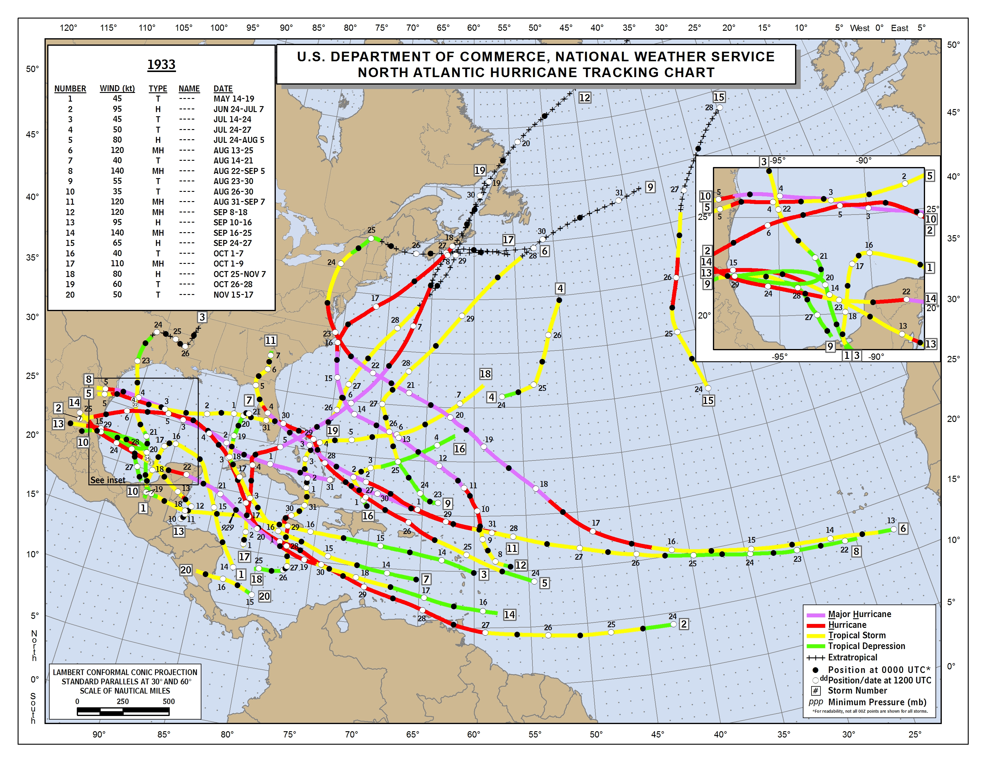
This scenario very nearly occurred in 1933 with Storms Eight and Eleven, both of which were major hurricanes on 3 September.
Last edited by Shell Mound on Tue Aug 18, 2020 11:06 pm, edited 1 time in total.
2 likes
CVW / MiamiensisWx / Shell Mound
The posts in this forum are NOT official forecasts and should not be used as such. They are just the opinion of the poster and may or may not be backed by sound meteorological data. They are NOT endorsed by any professional institution or STORM2K. For official information, please refer to products from the NHC and NWS.
-
toad strangler

- S2K Supporter
- Posts: 4546
- Joined: Sun Jul 28, 2013 3:09 pm
- Location: Earth
- Contact:
Re: ATL: INVEST 98L - Models
Shell Mound wrote:caneseddy wrote:That's a monster HP on the ICON. No turn out to sea on this run. Double landfall for Florida. Middle Keys, then the Big Bend area/central Panhandle as a major
It would be rather unlikely for a strong hurricane to make landfall in the Keys so soon after Irma (2017). If 98L heads to South FL, then Miami is more likely.
Wow, please explain that one. These storms don't follow a script. Frances and Jeanne landfalled within TWO miles of each other and just TWO weeks apart in 2004. NOTHING since then.
7 likes
My Weather Station
https://www.wunderground.com/dashboard/pws/KFLPORTS603
https://www.wunderground.com/dashboard/pws/KFLPORTS603
-
TheStormExpert
Re: ATL: INVEST 98L - Models
Shell Mound wrote:caneseddy wrote:That's a monster HP on the ICON. No turn out to sea on this run. Double landfall for Florida. Middle Keys, then the Big Bend area/central Panhandle as a major
It would be rather unlikely for a strong hurricane to make landfall in the Keys so soon after Irma (2017). If 98L heads to South FL, then Miami is more likely.
This makes literally no sense! So how do you explain Frances and Jeanne both making landfall in the same exact location in East-Central Florida just three weeks apart?
5 likes
-
eastcoastFL
- Category 5
- Posts: 3996
- Age: 44
- Joined: Thu Apr 12, 2007 12:29 pm
- Location: Palm City, FL
Re: ATL: INVEST 98L - Models
Shell Mound wrote:caneseddy wrote:That's a monster HP on the ICON. No turn out to sea on this run. Double landfall for Florida. Middle Keys, then the Big Bend area/central Panhandle as a major
It would be rather unlikely for a strong hurricane to make landfall in the Keys so soon after Irma (2017). If 98L heads to South FL, then Miami is more likely.
Is that just based off of the Odds? I don’t think it’s too crazy for the keys to get hit every 3 years. We had Frances and Jeanne just 3 weeks apart right here, same spot
3 likes
Personal Forecast Disclaimer:
The posts in this forum are NOT official forecast and should not be used as such. They are just the opinion of the poster and may or may not be backed by sound meteorological data. They are NOT endorsed by any professional institution or storm2k.org. For official information, please refer to the NHC and NWS products.
The posts in this forum are NOT official forecast and should not be used as such. They are just the opinion of the poster and may or may not be backed by sound meteorological data. They are NOT endorsed by any professional institution or storm2k.org. For official information, please refer to the NHC and NWS products.
-
Shell Mound
- Category 5
- Posts: 2432
- Age: 33
- Joined: Thu Sep 07, 2017 3:39 pm
- Location: St. Petersburg, FL → Scandinavia
Re: ATL: INVEST 98L - Models
toad strangler wrote:Shell Mound wrote:caneseddy wrote:That's a monster HP on the ICON. No turn out to sea on this run. Double landfall for Florida. Middle Keys, then the Big Bend area/central Panhandle as a major
It would be rather unlikely for a strong hurricane to make landfall in the Keys so soon after Irma (2017). If 98L heads to South FL, then Miami is more likely.
Wow, please explain that one. These storms don't follow a script. Frances and Jeanne landfalled within TWO miles of each other and just TWO weeks apart in 2004. NOTHING since then.
Climatologically, hurricane landfalls are rare, and two (major?) hurricanes hitting the same area (Keys) within three years would be even rarer. But I could be wrong.
0 likes
CVW / MiamiensisWx / Shell Mound
The posts in this forum are NOT official forecasts and should not be used as such. They are just the opinion of the poster and may or may not be backed by sound meteorological data. They are NOT endorsed by any professional institution or STORM2K. For official information, please refer to products from the NHC and NWS.
-
Blown Away
- S2K Supporter
- Posts: 10253
- Joined: Wed May 26, 2004 6:17 am
Re: ATL: INVEST 98L - Models
00z GFS 126 hrs... Coming off Cuba, circulation better defined than 18z... Should begin moving more NW
0 likes
Hurricane Eye Experience: David 79, Irene 99, Frances 04, Jeanne 04, Wilma 05… Hurricane Brush Experience: Andrew 92, Erin 95, Floyd 99, Matthew 16, Irma 17, Ian 22, Nicole 22…
-
eastcoastFL
- Category 5
- Posts: 3996
- Age: 44
- Joined: Thu Apr 12, 2007 12:29 pm
- Location: Palm City, FL
Re: ATL: INVEST 98L - Models
Gfs 132hrs blob heading towards Fl
0 likes
Personal Forecast Disclaimer:
The posts in this forum are NOT official forecast and should not be used as such. They are just the opinion of the poster and may or may not be backed by sound meteorological data. They are NOT endorsed by any professional institution or storm2k.org. For official information, please refer to the NHC and NWS products.
The posts in this forum are NOT official forecast and should not be used as such. They are just the opinion of the poster and may or may not be backed by sound meteorological data. They are NOT endorsed by any professional institution or storm2k.org. For official information, please refer to the NHC and NWS products.

Re: ATL: INVEST 98L - Models
TheStormExpert wrote:Levi Cowan said don’t bother looking at the models until something consolidates.
I didn't get to watch it, but his video yesterday popped up on my youtube feed and had like 21,000 views. That's pretty awesome for him.
0 likes
-
TheStormExpert
Re: ATL: INVEST 98L - Models
Shell Mound wrote:toad strangler wrote:Shell Mound wrote:It would be rather unlikely for a strong hurricane to make landfall in the Keys so soon after Irma (2017). If 98L heads to South FL, then Miami is more likely.
Wow, please explain that one. These storms don't follow a script. Frances and Jeanne landfalled within TWO miles of each other and just TWO weeks apart in 2004. NOTHING since then.
Climatologically, hurricane landfalls are rare, and two (major?) hurricanes hitting the same area (Keys) within three years would be even rarer. But I could be wrong.
Rare, yes. But not impossible. Mother Nature does what she wants!
0 likes
-
AutoPenalti
- Category 5
- Posts: 4091
- Age: 29
- Joined: Mon Aug 17, 2015 4:16 pm
- Location: Ft. Lauderdale, Florida
Re: ATL: INVEST 98L - Models
Shell Mound wrote:toad strangler wrote:Shell Mound wrote:It would be rather unlikely for a strong hurricane to make landfall in the Keys so soon after Irma (2017). If 98L heads to South FL, then Miami is more likely.
Wow, please explain that one. These storms don't follow a script. Frances and Jeanne landfalled within TWO miles of each other and just TWO weeks apart in 2004. NOTHING since then.
Climatologically, hurricane landfalls are rare, and two (major?) hurricanes hitting the same area (Keys) within three years would be even rarer. But I could be wrong.
It would be unlikely but not impossible. 2004 would like to have a word in that case.
1 likes
The posts in this forum are NOT official forecasts and should not be used as such. They are just the opinion of the poster and may or may not be backed by sound meteorological data. They are NOT endorsed by any professional institution or STORM2K. For official information, please refer to products from the NHC and NWS.
Model Runs Cheat Sheet:
GFS (5:30 AM/PM, 11:30 AM/PM)
HWRF, GFDL, UKMET, NAVGEM (6:30-8:00 AM/PM, 12:30-2:00 AM/PM)
ECMWF (1:45 AM/PM)
TCVN is a weighted averaged
Who is online
Users browsing this forum: No registered users and 47 guests