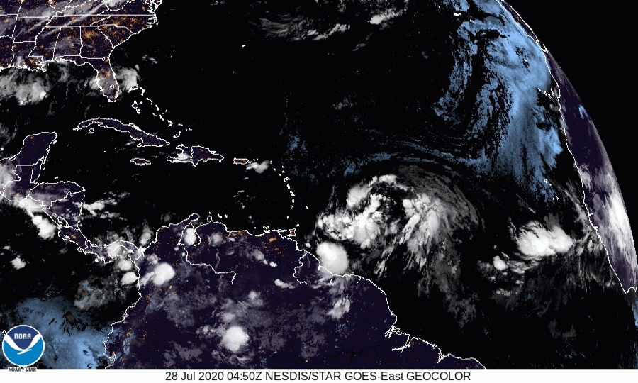
ATL: ISAIAS - Post-Tropical - Discussion

Moderator: S2k Moderators

Message
Author
User avatar
ScottNAtlanta
Category 5
Category 5
Posts: 2367
Joined: Sat May 25, 2013 3:11 pm
Location: Atlanta, GA

Re: ATL: INVEST 92L - Discussion

#641 Postby ScottNAtlanta » Tue Jul 28, 2020 8:52 am

NDG wrote:


But still looks elongated.

Looking at the ASCAT above, the western lobe is pinching off
0 likes   
The posts in this forum are NOT official forecast and should not be used as such. They are just the opinion of the poster and may or may not be backed by sound meteorological data. They are NOT endorsed by any professional institution or storm2k.org. For official information, please refer to the NHC and NWS products.

plasticup

Re: ATL: INVEST 92L - Discussion

#642 Postby plasticup » Tue Jul 28, 2020 8:58 am

sma10 wrote:
gatorcane wrote:Saved loop. Looks to be big and gradually organizing while moving quickly. Still a lot of SAL around it:

https://i.postimg.cc/zBKtGCng/BC63-A42-C-B225-4-BFF-BDC6-EA1-A8-D1-B0-F48.gif


Nice image. The circulation on this system is a bit larger than Gonzalo, no?


Just a little :lol:
7 likes   

User avatar
Nancy Smar
Category 5
Category 5
Posts: 1081
Age: 24
Joined: Wed Aug 16, 2017 10:03 pm

Re: ATL: INVEST 92L - Discussion

#643 Postby Nancy Smar » Tue Jul 28, 2020 8:58 am

Last edited by Nancy Smar on Tue Jul 28, 2020 9:01 am, edited 2 times in total.
3 likes   

St0rmTh0r
Category 1
Category 1
Posts: 369
Joined: Tue Jul 14, 2020 8:04 pm

Re: ATL: INVEST 92L - Discussion

#644 Postby St0rmTh0r » Tue Jul 28, 2020 9:00 am

Looks like the sw area people were talking about yesterday is starting to take over big changes to track coming if this happens
1 likes   

User avatar
wxman57
Moderator-Pro Met
Moderator-Pro Met
Posts: 22979
Age: 67
Joined: Sat Jun 21, 2003 8:06 pm
Location: Houston, TX (southwest)

Re: ATL: INVEST 92L - Discussion

#645 Postby wxman57 » Tue Jul 28, 2020 9:01 am

SouthDadeFish wrote:I don't understand why NHC isn't issuing advisories for a Potential Tropical Cyclone. The Antilles are within range of watches/warnings. My guess is the NHC is waiting until they feel more confident where a center will consolidate. Possibly after the recon flight today, if recon doesn't find a TC already.


I sure wish I had the option of not issuing an advisory until I was more confident where a potential storm will track. We started issuing 7-day forecasts on Sunday for this disturbance. I'm quite confident in it tracking across the NE Caribbean Wed/Thu as a 35-40 kt TS. Beyond then, who knows? Consensus takes it near SE FL on Sunday as a very slow-moving storm. EC and GFS take it into south Florida as a depression on Sunday then dissipate it inland. GFS is indicating a big battle with dry air after exiting the NE Caribbean on Thursday, leading to its demise as it nears Florida. A small percentage of the GFS and Euro ensemble members indicate a track toward the Carolinas, but most EC members either dissipate it in a few days or have it reaching south Florida as a depression. Only about 8 of the 51 members take it to the Carolinas as a TS or H. The "new" GFS makes it a major hurricane into the Carolinas on Monday night. It remains to be seen how much we can trust this updated version of the GFS. Perhaps the recon data will help tonight's models? Would help if they sent out a G-IV to sample the atmosphere in its path.
14 likes   

User avatar
AubreyStorm
Category 1
Category 1
Posts: 337
Age: 44
Joined: Fri Jun 16, 2017 6:21 pm
Location: Texas, USA

Re: ATL: INVEST 92L - Discussion

#646 Postby AubreyStorm » Tue Jul 28, 2020 9:02 am


Hmmmmmmm? At 11am TD?
1 likes   
The posts are NOT an official forecast. Please REFER to the NHC and NWS for official forecasts and products.

USTropics
Professional-Met
Professional-Met
Posts: 2651
Joined: Sun Aug 12, 2007 3:45 am
Location: Florida State University

Re: ATL: INVEST 92L - Discussion

#647 Postby USTropics » Tue Jul 28, 2020 9:03 am

Upper-level consolidation over the past 24 hours really tells the story:
Image

I agree with Aric, the eastern vorticity will begin to become stretched out from west to east soon. You can see this happening in the mid-levels now:
Image
2 likes   

User avatar
Nancy Smar
Category 5
Category 5
Posts: 1081
Age: 24
Joined: Wed Aug 16, 2017 10:03 pm

Re: ATL: INVEST 92L - Discussion

#648 Postby Nancy Smar » Tue Jul 28, 2020 9:05 am

AubreyStorm wrote:


Hmmmmmmm? At 11am TD?

Probably Potential Tropical Cyclone Nine.
4 likes   

User avatar
Kazmit
Category 5
Category 5
Posts: 2124
Age: 22
Joined: Mon Jul 25, 2016 8:49 am
Location: Williamsburg, VA / Bermuda

Re: ATL: INVEST 92L - Discussion

#649 Postby Kazmit » Tue Jul 28, 2020 9:11 am

AubreyStorm wrote:


Hmmmmmmm? At 11am TD?

It already has TS winds. Probably a PTC.
0 likes   
Igor 2010, Sandy 2012, Fay 2014, Gonzalo 2014, Joaquin 2015, Nicole 2016, Humberto 2019

I am only a tropical weather enthusiast. My predictions are not official and may or may not be backed by sound meteorological data. For official information, please refer to the NHC and NWS products.

User avatar
Nancy Smar
Category 5
Category 5
Posts: 1081
Age: 24
Joined: Wed Aug 16, 2017 10:03 pm

Re: ATL: INVEST 92L - Discussion

#650 Postby Nancy Smar » Tue Jul 28, 2020 9:14 am

AL, 09, 2020072812, , BEST, 0, 135N, 528W, 35, 1007, DB, 34, NEQ, 200, 0, 0, 120, 1012, 300, 150, 0, 0, L, 0, , 0, 0, NINE, S, 0, , 0, 0, 0, 0, genesis-num, 021, TRANSITIONED, alB22020 to al092020,
4 likes   

User avatar
ouragans
Category 1
Category 1
Posts: 490
Age: 53
Joined: Sun Jun 12, 2011 12:09 pm
Location: Abymes, Guadeloupe F.W.I
Contact:

Re: ATL: NINE - Potential Tropical Cyclone - Discussion

#651 Postby ouragans » Tue Jul 28, 2020 9:20 am

TD with TS winds? That's weird....
0 likes   
Personal forecast disclaimer
This post is a personal point of view, not an information. Please refer to official statements for life-threatening decisions.

David '79, Frederic '79, Hugo '89, Iris, Luis & Marilyn '95, Georges '98, Lenny '99, Dean '07, Irma '17, Maria '17, Fiona '22, Philippe '23, Tammy '23
16°13'33.3,"6N -61°36'39.5"W

TheStormExpert

Re: ATL: NINE - Potential Tropical Cyclone - Discussion

#652 Postby TheStormExpert » Tue Jul 28, 2020 9:22 am

First Potential Tropical Cyclone advisory coming at 11am it looks in don’t remember how long. :lol:
1 likes   

Mialco
Tropical Low
Tropical Low
Posts: 14
Joined: Thu Aug 17, 2017 5:33 pm

Re: ATL: INVEST 92L - Discussion

#653 Postby Mialco » Tue Jul 28, 2020 9:24 am

Considering that the leading cloud mass is practically on our doorstep here in Barbados, I imagine that at least PTC advisories should be initiated in the next update. By the time the hurricane hunter gets into it, we might already be seeing an increase in deteriorating conditions
#watchingclosely
6 likes   

User avatar
Nancy Smar
Category 5
Category 5
Posts: 1081
Age: 24
Joined: Wed Aug 16, 2017 10:03 pm

Re: ATL: NINE - Potential Tropical Cyclone - Discussion

#654 Postby Nancy Smar » Tue Jul 28, 2020 9:26 am

Special Message from NHC Issued 28 Jul 2020 14:25 UTC
NHC will initiate advisories on Potential Tropical Cyclone Nine, located about 400 miles east of the Windward Islands, at 11 am AST.
8 likes   

TheStormExpert

Re: ATL: NINE - Potential Tropical Cyclone - Discussion

#655 Postby TheStormExpert » Tue Jul 28, 2020 9:27 am

ouragans wrote:TD with TS winds? That's weird....

This likely means if and when it gets better organized it’ll likely be upgraded directly to TS.
9 likes   

User avatar
ouragans
Category 1
Category 1
Posts: 490
Age: 53
Joined: Sun Jun 12, 2011 12:09 pm
Location: Abymes, Guadeloupe F.W.I
Contact:

Re: ATL: NINE - Potential Tropical Cyclone - Discussion

#656 Postby ouragans » Tue Jul 28, 2020 9:29 am

TheStormExpert wrote:
ouragans wrote:TD with TS winds? That's weird....

This likely means if and when it gets better organized it’ll likely be upgraded directly to TS.


I just saw they will upgrade to PTC. Logic, but this should have been done at 9z
1 likes   
Personal forecast disclaimer
This post is a personal point of view, not an information. Please refer to official statements for life-threatening decisions.

David '79, Frederic '79, Hugo '89, Iris, Luis & Marilyn '95, Georges '98, Lenny '99, Dean '07, Irma '17, Maria '17, Fiona '22, Philippe '23, Tammy '23
16°13'33.3,"6N -61°36'39.5"W

Florida1118

Re: ATL: NINE - Potential Tropical Cyclone - Discussion

#657 Postby Florida1118 » Tue Jul 28, 2020 9:30 am

TheStormExpert wrote:
ouragans wrote:TD with TS winds? That's weird....

This likely means if and when it gets better organized it’ll likely be upgraded directly to TS.


"Probably time to put this Invest to rest"
9 likes   

Dean4Storms
S2K Supporter
S2K Supporter
Posts: 6358
Age: 62
Joined: Sun Aug 31, 2003 1:01 pm
Location: Miramar Bch. FL

Re: ATL: NINE - Potential Tropical Cyclone - Discussion

#658 Postby Dean4Storms » Tue Jul 28, 2020 9:36 am

That western portion of the wave sure looks suspicious on satellite and if it goes on to develop this is a Carib. Sea runner IMO.
0 likes   

Shell Mound
Category 5
Category 5
Posts: 2434
Age: 32
Joined: Thu Sep 07, 2017 3:39 pm
Location: St. Petersburg, FL → Scandinavia

Re: ATL: NINE - Potential Tropical Cyclone - Discussion

#659 Postby Shell Mound » Tue Jul 28, 2020 9:38 am

Based on the latest visible imagery, the southwestern lobe clearly seems to be taking over. Low-level rotation near the northeastern lobe is weakening and veering, while low-level rotation is backing and strengthening near the southwestern lobe, so for the first time the circulation seems to be becoming a bit more symmetrical on balance. A wide-angle view seems to confirm this new, gradual trend. A future LLC seems increasingly likely to consolidate in the vicinity of the southwestern lobe. Additionally, inflow seems to be strengthening in this area, based on the movement of the low-level clouds.
4 likes   
CVW / MiamiensisWx / Shell Mound
The posts in this forum are NOT official forecasts and should not be used as such. They are just the opinion of the poster and may or may not be backed by sound meteorological data. They are NOT endorsed by any professional institution or STORM2K. For official information, please refer to products from the NHC and NWS.

User avatar
Hurricaneman
Category 5
Category 5
Posts: 7351
Age: 45
Joined: Tue Aug 31, 2004 3:24 pm
Location: central florida

Re: ATL: NINE - Potential Tropical Cyclone - Discussion

#660 Postby Hurricaneman » Tue Jul 28, 2020 9:42 am

My forecast for this

Track hasn’t changed since my last forecast except a second US landfall near St Marks Fl and a wee bit slower

Intensity I’m inching up a bit in the long term

Now. PTC. 40mph
12hrs. TS. 45mph
24hrs. TS. 50mph
36hrs. TS. 65mph
48hrs. TS. 65mph
72hrs. TS. 60mph
96hrs. TS. 60mph
120hrs. TS. 70mph
144hrs. C1. 80mph off Palm Beach
0 likes   


Return to “2020”

Who is online

Users browsing this forum: No registered users and 8 guests