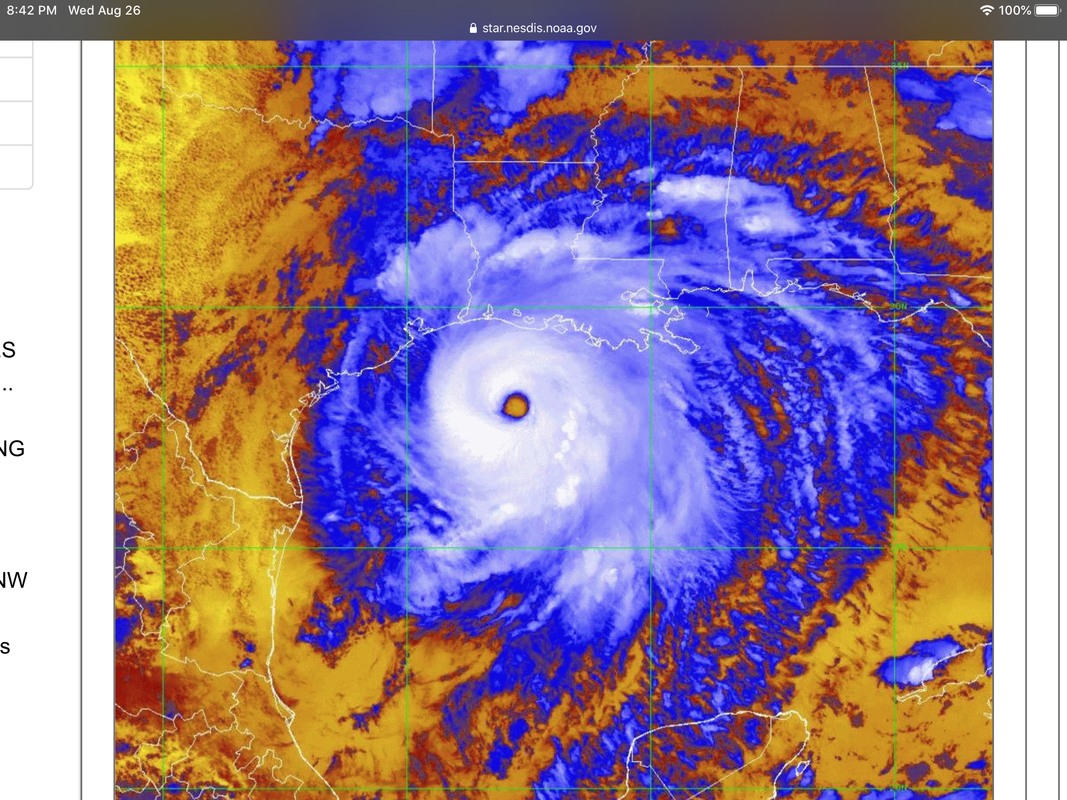
ATL: LAURA - Post-Tropical - Discussion

Moderator: S2k Moderators

Message
Author
User avatar
HurricaneEdouard
Tropical Storm
Tropical Storm
Posts: 140
Joined: Sun May 03, 2015 11:09 am

Re: ATL: LAURA - Hurricane - Discussion

#6761 Postby HurricaneEdouard » Wed Aug 26, 2020 7:37 pm

Kingarabian wrote:
HurricaneEdouard wrote:Wind shear over Laura is 25-30 knots. Incredibly impressive intensification given the cooler continental shelf waters and the now moderate wind shear; if the core continues to hold up, I do expect a Category 5 hurricane given these rapid pressure drops.

[url]https://i.imgur.com/qpIgV8i.jpg[url]

This type of shear so long it remains away from the mid levels will enhance the system and its effects until it moves in land. Around then it'll start to get shredded.

According to Levi it is mid-level shear...?
0 likes   
You know you're a hurricane nut, when your main source of adrenaline is reading old hurricane advisories...

supercane4867
Category 5
Category 5
Posts: 4966
Joined: Wed Nov 14, 2012 10:43 am

Re: ATL: LAURA - Hurricane - Discussion

#6762 Postby supercane4867 » Wed Aug 26, 2020 7:37 pm

WV channel is very telling in terms of intensification trend.

https://weather.cod.edu/satrad/?parms=m ... =undefined

Image
4 likes   

ozonepete
Professional-Met
Professional-Met
Posts: 4743
Joined: Mon Sep 07, 2009 3:23 pm
Location: From Ozone Park, NYC / Now in Brooklyn, NY

Re: ATL: LAURA - Hurricane - Discussion

#6763 Postby ozonepete » Wed Aug 26, 2020 7:38 pm

supercane4867 wrote:
HurricaneEdouard wrote:Wind shear over Laura is 25-30 knots. Incredibly impressive intensification given the cooler continental shelf waters and the now moderate wind shear; if the core continues to hold up, I do expect a Category 5 hurricane given these rapid pressure drops.

https://i.imgur.com/qpIgV8i.jpg

CIMSS shear map is not accurate for real-time reference. Maximum wind shear that Laura is currently experiencing is probably no more than 15-20kts.


Yes, please don't use CIMSS shear maps like that for real time. Besides the fact that it is not totally real time it also has a 50-100 mile grid error so the high shear you see with those red lines could be 100 miles further to the north inland and thus having no effect on this storm.
8 likes   

User avatar
ColdMiser123
Professional-Met
Professional-Met
Posts: 904
Age: 29
Joined: Mon Sep 26, 2016 3:26 pm
Location: Northeast US

Re: ATL: LAURA - Hurricane - Discussion

#6764 Postby ColdMiser123 » Wed Aug 26, 2020 7:39 pm

Dropsonde splashed at 940 mb with 30 KT surface wind, supports 937 mb, a 3 mb drop in an hour. Still deepening.
13 likes   
B.S., M.S., Meteorology & Atmospheric Science

User avatar
HurricaneEdouard
Tropical Storm
Tropical Storm
Posts: 140
Joined: Sun May 03, 2015 11:09 am

Re: ATL: LAURA - Hurricane - Discussion

#6765 Postby HurricaneEdouard » Wed Aug 26, 2020 7:39 pm

Hammy wrote:
HurricaneEdouard wrote:Wind shear over Laura is 25-30 knots. Incredibly impressive intensification given the cooler continental shelf waters and the now moderate wind shear; if the core continues to hold up, I wouldn't be surprised if we just edge into Category 5 given these rapid pressure drops.

https://i.imgur.com/qpIgV8i.jpg


Matthew rapidly intensified under similar conditions.

Often seems to briefly boost a hurricane before landfall.
0 likes   
You know you're a hurricane nut, when your main source of adrenaline is reading old hurricane advisories...

supercane4867
Category 5
Category 5
Posts: 4966
Joined: Wed Nov 14, 2012 10:43 am

Re: ATL: LAURA - Hurricane - Discussion

#6766 Postby supercane4867 » Wed Aug 26, 2020 7:39 pm

It's only a matter of time before the two recon missions find CAT5 winds somewhere in that eyewall. Chill...
1 likes   

User avatar
Cataegis96
Professional-Met
Professional-Met
Posts: 54
Age: 29
Joined: Mon Jul 10, 2017 3:46 pm
Contact:

Re: ATL: LAURA - Hurricane - Discussion

#6767 Postby Cataegis96 » Wed Aug 26, 2020 7:39 pm

Absolutely speechless what is happening right now. The E-W pass should confirm a cat 5 imho.
9 likes   
Lead Meteorologist Mars, Inc
WE ARE! The Pennsylvania State University 2018
UA U KNOW! University at Albany, SUNY 2020

cfisher

Re: ATL: LAURA - Hurricane - Discussion

#6768 Postby cfisher » Wed Aug 26, 2020 7:39 pm

Laura's outflow is obliterating the trough that sheared Marco.
1 likes   

Powellrm
Tropical Storm
Tropical Storm
Posts: 102
Joined: Sun Sep 03, 2017 1:40 pm

Re: ATL: LAURA - Hurricane - Discussion

#6769 Postby Powellrm » Wed Aug 26, 2020 7:39 pm

wkwally wrote:
Nimbus wrote:If Laura stays fairly tightly wound up and makes landfall as a cat 4.9 in a relatively abandoned community it might be better than if the squall lines band outward quickly expanding the wind field over 100 miles.

cat 4.9?????????????


*cat 4.99
2 likes   

xironman
S2K Supporter
S2K Supporter
Posts: 2522
Joined: Sun Jun 10, 2007 4:53 pm
Location: NoVA

Re: ATL: LAURA - Hurricane - Discussion

#6770 Postby xironman » Wed Aug 26, 2020 7:39 pm

https://twitter.com/iCyclone/status/129 ... gr%5Etweet

Sulfur looks like a good choice for being in the eye, having a parking garage not so much.
1 likes   

Mob1
Tropical Low
Tropical Low
Posts: 32
Joined: Sun Jun 07, 2020 11:03 am

Re: ATL: LAURA - Hurricane - Discussion

#6771 Postby Mob1 » Wed Aug 26, 2020 7:39 pm

The smallest east wobble can make a MASSIVE difference for how severe the storm surge is in Lake Charles. On the flip side of that, any western component to Laura's movement and they're in a lot of trouble.
1 likes   

User avatar
Highteeld
Category 5
Category 5
Posts: 2139
Age: 41
Joined: Tue Jan 30, 2018 9:10 pm
Location: Chicago

Re: ATL: LAURA - Hurricane - Discussion

#6772 Postby Highteeld » Wed Aug 26, 2020 7:41 pm

dropping 3 mb/hr

Image

Image
0 likes   
Very useful information on the Dvorak Technique --

https://severe.worldweather.wmo.int/TCF ... kBeven.pdf

SunnyThoughts
Category 5
Category 5
Posts: 2263
Joined: Wed Jul 09, 2003 12:42 pm
Location: Pensacola, Florida

Re: ATL: LAURA - Hurricane - Discussion

#6773 Postby SunnyThoughts » Wed Aug 26, 2020 7:41 pm

https://www.youtube.com/watch?v=UJMX4AX ... e=youtu.be

This guy has cameras rolling in Lake Charles ( I believe its lake charles) he isns't there...but has cameras rolling and is online ..says will keep the cameras going until loses power.
4 likes   

User avatar
NDG
S2K Supporter
S2K Supporter
Posts: 15446
Joined: Sun Jul 09, 2006 10:14 pm
Location: Orlando, FL

Re: ATL: LAURA - Hurricane - Discussion

#6774 Postby NDG » Wed Aug 26, 2020 7:42 pm

I think they need to upgrade it to a Cat 5, it continues to strengthen is surely not leveling off just yet, but what does just a few miles will do, still the same destruction but upgrading it will make people leave in case they haven't yet.
0 likes   

User avatar
KWT
Category 5
Category 5
Posts: 31415
Joined: Tue Aug 17, 2004 11:02 am
Location: UK!!!

Re: ATL: LAURA - Hurricane - Discussion

#6775 Postby KWT » Wed Aug 26, 2020 7:42 pm

Dropsonde supports 937mbs at the moment, so still in a deepening phase. Remember also that the 140kts winds were found at 937mbs on one of the previous dropsonde's in the northern eyewall.

Must be real close now everyone.
6 likes   
Personal Forecast Disclaimer:
The posts in this forum are NOT official forecast and should not be used as such. They are just the opinion of the poster and may or may not be backed by sound meteorological data. They are NOT endorsed by any professional institution or storm2k.org. For official information, please refer to the NHC and NWS products

User avatar
AnnularCane
S2K Supporter
S2K Supporter
Posts: 2862
Joined: Thu Jun 08, 2006 9:18 am
Location: Wytheville, VA

Re: ATL: LAURA - Hurricane - Discussion

#6776 Postby AnnularCane » Wed Aug 26, 2020 7:43 pm

cfisher wrote:Laura's outflow is obliterating the trough that sheared Marco.


Somehow that doesn't surprise me.
4 likes   

PandaCitrus
Category 1
Category 1
Posts: 424
Joined: Mon Sep 04, 2017 2:44 pm

Re: ATL: LAURA - Hurricane - Discussion

#6777 Postby PandaCitrus » Wed Aug 26, 2020 7:43 pm

Right now is setting up to be a wipeout scenario for Lake Charles. They will get the eye directly over them or the eyewall and even though 30 miles inland...should still mean Cat 3/4 sustained winds at least with Cat 5 gusts possible. Along with record surge. The city is probably wiped out and the Lake Charles metro has almost 200,000 people so it's going to be a major disaster.

Nimbus wrote:If Laura stays fairly tightly wound up and makes landfall as a cat 4.9 in a relatively abandoned community it might be better than if the squall lines band outward quickly expanding the wind field over 100 miles.
0 likes   

User avatar
gatorcane
S2K Supporter
S2K Supporter
Posts: 23691
Age: 47
Joined: Sun Mar 13, 2005 3:54 pm
Location: Boca Raton, FL

Re: ATL: LAURA - Hurricane - Discussion

#6778 Postby gatorcane » Wed Aug 26, 2020 7:43 pm

:eek:

Image
Last edited by gatorcane on Wed Aug 26, 2020 7:44 pm, edited 1 time in total.
1 likes   

User avatar
Highteeld
Category 5
Category 5
Posts: 2139
Age: 41
Joined: Tue Jan 30, 2018 9:10 pm
Location: Chicago

Re: ATL: LAURA - Hurricane - Discussion

#6779 Postby Highteeld » Wed Aug 26, 2020 7:43 pm

Nearly tied with Dorian in terms of eye temp. Also only .09*C shy of the 90*C threshold most cat 5's experience per ADT.

2020AUG27 002020 6.4 929.0 124.6 6.4 6.5 6.5 NO LIMIT OFF OFF OFF OFF 21.21 -68.70 EYE 26 IR 69.2 28.60 93.00 ARCHER GOES16 38.7
8 likes   
Very useful information on the Dvorak Technique --

https://severe.worldweather.wmo.int/TCF ... kBeven.pdf

User avatar
GCANE
S2K Supporter
S2K Supporter
Posts: 11496
Joined: Mon Oct 22, 2007 8:03 am

Re: ATL: LAURA - Hurricane - Discussion

#6780 Postby GCANE » Wed Aug 26, 2020 7:43 pm

Eyewall lightning is increasing
1 likes   


Return to “2020”

Who is online

Users browsing this forum: No registered users and 4 guests