THERE IS STILL SIGNIFICANT UNCERTAINTY FOR LATE-WEEKEND AND INTO
NEXT WEEK REGARDING WEATHER CONDITIONS.
ATL: ETA - Models
Moderator: S2k Moderators
-
HurricaneBelle

- S2K Supporter

- Posts: 1203
- Joined: Sun Aug 27, 2006 6:12 pm
- Location: Clearwater, FL
Re: ATL: ETA - Models
I like how NWS Tampa Bay refers to Eta without actually referring to Eta in its latest forecast discussion:
5 likes

-
Blown Away

- S2K Supporter
- Posts: 10253
- Joined: Wed May 26, 2004 6:17 am
Re: ATL: ETA - Models

06z Guidance

12z Guidance

12z Intensity Guidance.
0 likes
Hurricane Eye Experience: David 79, Irene 99, Frances 04, Jeanne 04, Wilma 05… Hurricane Brush Experience: Andrew 92, Erin 95, Floyd 99, Matthew 16, Irma 17, Ian 22, Nicole 22…

Re: ATL: ETA - Models
With the UKmet even going NE now, the next day 5 day track will be shifted a bit!
0 likes
-
AutoPenalti
- Category 5

- Posts: 4091
- Age: 29
- Joined: Mon Aug 17, 2015 4:16 pm
- Location: Ft. Lauderdale, Florida
Re: ATL: ETA - Models
Adrian, you think this will still have a core after 3 days in land over some the highest terrain in Central America?
0 likes
The posts in this forum are NOT official forecasts and should not be used as such. They are just the opinion of the poster and may or may not be backed by sound meteorological data. They are NOT endorsed by any professional institution or STORM2K. For official information, please refer to products from the NHC and NWS.
Model Runs Cheat Sheet:
GFS (5:30 AM/PM, 11:30 AM/PM)
HWRF, GFDL, UKMET, NAVGEM (6:30-8:00 AM/PM, 12:30-2:00 AM/PM)
ECMWF (1:45 AM/PM)
TCVN is a weighted averaged
-
eastcoastFL

- Category 5
- Posts: 3996
- Age: 43
- Joined: Thu Apr 12, 2007 12:29 pm
- Location: Palm City, FL
Re: ATL: ETA - Models
toad strangler wrote:SFLcane wrote:TheStormExpert wrote:I guess it’s becoming more that there will be a hurricane in the NW Caribbean once Eta re-emerges in the Gulf of Honduras later this week. From there I could see this meandering around the NW Caribbean for a bit. The 06z GFS has a major hitting South Florida beyond 300hrs., been there too many times before to know better.
It’s not just op models there is ensemble support
from the EPS and GEFS.
A mid November strong 'cane into the FL peninsula. That would be one for the books. The ONLY one for the books.
The thing about trends is that eventually they end and things change. Those 1 in 500 year storms eventually show up and norms are always defied at some point. You really can’t deny the set up with the ridge still in place so it’s real possibility. Now how strong it is when it gets towards CONJS is anyone’s guess.
0 likes
Personal Forecast Disclaimer:
The posts in this forum are NOT official forecast and should not be used as such. They are just the opinion of the poster and may or may not be backed by sound meteorological data. They are NOT endorsed by any professional institution or storm2k.org. For official information, please refer to the NHC and NWS products.
The posts in this forum are NOT official forecast and should not be used as such. They are just the opinion of the poster and may or may not be backed by sound meteorological data. They are NOT endorsed by any professional institution or storm2k.org. For official information, please refer to the NHC and NWS products.
-
SFLcane

- S2K Supporter
- Posts: 10281
- Age: 48
- Joined: Sat Jun 05, 2010 1:44 pm
- Location: Lake Worth Florida
Re: ATL: ETA - Models
AutoPenalti wrote:Adrian, you think this will still have a core after 3 days in land over some the highest terrain in Central America?
Yes I think there will be some sort of a circulation left moving into the nw Caribbean. I also think the stronger this gets increases the odds also. Its rapidly intensifying this morning we are look looking potentially at high end cat 3 or 4 before it moves into CA.
Watching closely!
0 likes

Re: ATL: ETA - Models
Blown Away wrote:https://i.imgur.com/66vRCYH.jpg
06z Guidance
https://i.imgur.com/9FO61Ja.jpg
12z Guidance
https://i.imgur.com/ifdQ8pP.jpg
12z Intensity Guidance.
If that track where to verify Eta would go SE of South Florida.
0 likes
-
Weatherboy1

- Category 5
- Posts: 1190
- Age: 50
- Joined: Mon Jul 05, 2004 1:50 pm
- Location: Jupiter/Sarasota, FL
Re: ATL: ETA - Models
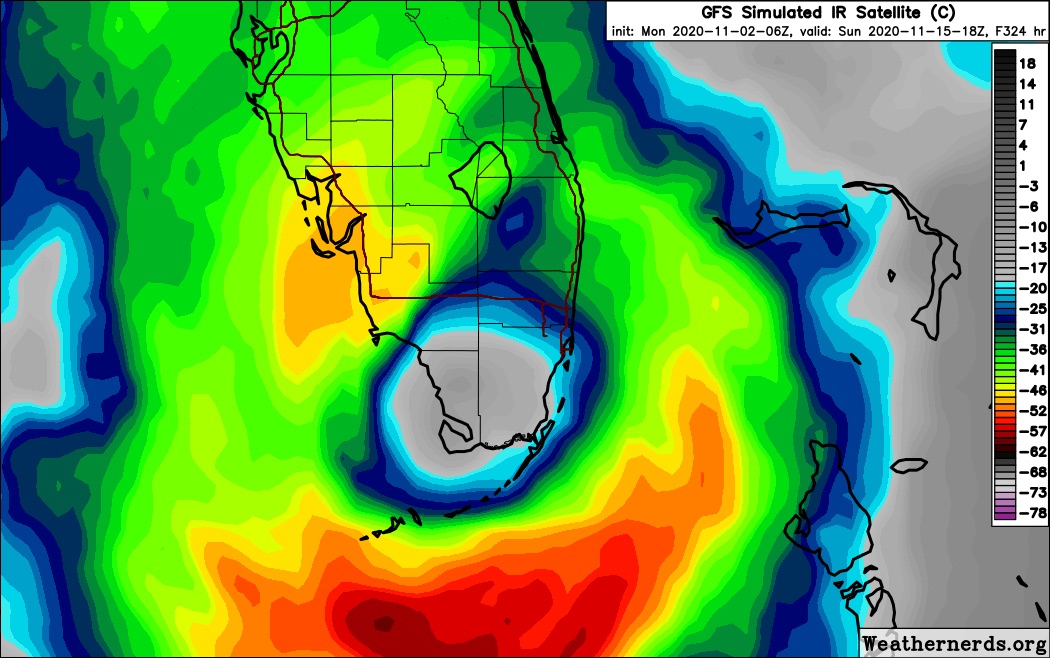
SFLcane wrote:I can see birds inside the eye.

https://i.postimg.cc/fR8t93JX/603-A7093-9831-4-C99-9294-4-E48934-F9724.jpg
So many Wilma memories conjured up by that simulated IR image!
4 likes
-
toad strangler

- S2K Supporter
- Posts: 4546
- Joined: Sun Jul 28, 2013 3:09 pm
- Location: Earth
- Contact:
Re: ATL: ETA - Models
SFLcane wrote:AutoPenalti wrote:Adrian, you think this will still have a core after 3 days in land over some the highest terrain in Central America?
Yes I think there will be some sort of a circulation left moving into the nw Caribbean. I also think the stronger this gets increases the odds also. Its rapidly intensifying this morning we are look looking potentially at high end cat 3 or 4 before it moves into CA.
Watching closely!
I would think that the stronger Eta gets the more it gets hurt by the mountains. A tight storm that unravels and loses all that momentum has a tougher time pulling it all back together. The models are surely struggling with that aspect.
0 likes
My Weather Station
https://www.wunderground.com/dashboard/pws/KFLPORTS603
https://www.wunderground.com/dashboard/pws/KFLPORTS603

Re: ATL: ETA - Models
It's about time to start playing Florida Model Bingo boy's and girls  . Everyone get their cards out and start checking off all the cities that models are projecting landfall. We should achieve a full-card bingo within the next 3 days along
2 likes
Andy D
(For official information, please refer to the NHC and NWS products.)
(For official information, please refer to the NHC and NWS products.)
Re: ATL: ETA - Models
toad strangler wrote:SFLcane wrote:AutoPenalti wrote:Adrian, you think this will still have a core after 3 days in land over some the highest terrain in Central America?
Yes I think there will be some sort of a circulation left moving into the nw Caribbean. I also think the stronger this gets increases the odds also. Its rapidly intensifying this morning we are look looking potentially at high end cat 3 or 4 before it moves into CA.
Watching closely!
I would think that the stronger Eta gets the more it gets hurt by the mountains. A tight storm that unravels and loses all that momentum has a tougher time pulling it all back together. The models are surely struggling with that aspect.
I would tend to agree. Pretty hard to see a broad wrecked mid level core to quickly re-consolidate north of Honduras. Perhaps land interaction will prove to occur over a significantly shorter period of time?
0 likes
Andy D
(For official information, please refer to the NHC and NWS products.)
(For official information, please refer to the NHC and NWS products.)
-
SFLcane
- S2K Supporter
- Posts: 10281
- Age: 48
- Joined: Sat Jun 05, 2010 1:44 pm
- Location: Lake Worth Florida
Re: ATL: ETA - Models
toad strangler wrote:SFLcane wrote:AutoPenalti wrote:Adrian, you think this will still have a core after 3 days in land over some the highest terrain in Central America?
Yes I think there will be some sort of a circulation left moving into the nw Caribbean. I also think the stronger this gets increases the odds also. Its rapidly intensifying this morning we are look looking potentially at high end cat 3 or 4 before it moves into CA.
Watching closely!
I would think that the stronger Eta gets the more it gets hurt by the mountains. A tight storm that unravels and loses all that momentum has a tougher time pulling it all back together. The models are surely struggling with that aspect.
I really think we are going to be looking at a potential hurricane in the nw Caribbean late this week. upgraded GEFS and euro ensembles are certainly showing that possibility. IF there’s something there we might be in trouble as it will be just waiting for a trof to scoop it up our way.
0 likes

Re: ATL: ETA - Models
boca wrote:Blown Away wrote:https://i.imgur.com/66vRCYH.jpg
06z Guidance
https://i.imgur.com/9FO61Ja.jpg
12z Guidance
https://i.imgur.com/ifdQ8pP.jpg
12z Intensity Guidance.
If that track where to verify Eta would go SE of South Florida.
Except that further out, these models show the high pressure building back west over Florida, leading to a 180 with movement west-nw before possibly bending back e ne with a passing trough
2 likes
-
p1nheadlarry

- Category 2

- Posts: 672
- Age: 34
- Joined: Wed Jan 29, 2014 2:42 pm
- Location: SR County FL
Re: ATL: ETA - Models
Just saw the long range GFS.
"Surely the long-range Euro isn't as insane." *checks*
"Surely the long-range Euro isn't as insane." *checks*
2 likes
--;->#GoNoles--;->.
-
Evil Jeremy

- S2K Supporter
- Posts: 5463
- Age: 32
- Joined: Mon Apr 10, 2006 2:10 pm
- Location: Los Angeles, CA
Re: ATL: ETA - Models
This seems like a fittingly unpredictable grand-finale (I hope) for the 2020 season. All the Globals show Eta thriving in the NW Carib around the end of this week, and they're all ejecting the system in different directions and different times. But they agree there will be a strong storm sitting in the area.
2 likes
Frances 04 / Jeanne 04 / Katrina 05 / Wilma 05 / Fay 08 / Debby 12 / Andrea 13 / Colin 16 / Hermine 16 / Matthew 16 / Irma 17
-
p1nheadlarry
- Category 2
- Posts: 672
- Age: 34
- Joined: Wed Jan 29, 2014 2:42 pm
- Location: SR County FL
Re: ATL: ETA - Models
toad strangler wrote:SFLcane wrote:TheStormExpert wrote:I guess it’s becoming more that there will be a hurricane in the NW Caribbean once Eta re-emerges in the Gulf of Honduras later this week. From there I could see this meandering around the NW Caribbean for a bit. The 06z GFS has a major hitting South Florida beyond 300hrs., been there too many times before to know better.
It’s not just op models there is ensemble support
from the EPS and GEFS.
A mid November strong 'cane into the FL peninsula. That would be one for the books. The ONLY one for the books.
Not the peninsula but Hurricane Kate hit Mexico Beach as a solid Cat-2 right around Thanksgiving in '85. Worst storm in the Big Bend region until Oct 10 2018.
0 likes
--;->#GoNoles--;->.
-
p1nheadlarry
- Category 2
- Posts: 672
- Age: 34
- Joined: Wed Jan 29, 2014 2:42 pm
- Location: SR County FL
-
toad strangler
- S2K Supporter
- Posts: 4546
- Joined: Sun Jul 28, 2013 3:09 pm
- Location: Earth
- Contact:
Re: ATL: ETA - Models
p1nheadlarry wrote:toad strangler wrote:SFLcane wrote:
It’s not just op models there is ensemble support
from the EPS and GEFS.
A mid November strong 'cane into the FL peninsula. That would be one for the books. The ONLY one for the books.
Not the peninsula but Hurricane Kate hit Mexico Beach as a solid Cat-2 right around Thanksgiving in '85. Worst storm in the Big Bend region until Oct 10 2018.
Indeed but Kate was not a Caribbean storm. She is one of your TWO examples since 1859 … the other was not of Caribbean origin either. So this would be a first time for the books should it happen. Still a long shot though.
0 likes
My Weather Station
https://www.wunderground.com/dashboard/pws/KFLPORTS603
https://www.wunderground.com/dashboard/pws/KFLPORTS603
-
SFLcane
- S2K Supporter
- Posts: 10281
- Age: 48
- Joined: Sat Jun 05, 2010 1:44 pm
- Location: Lake Worth Florida
Re: ATL: ETA - Models
Evil Jeremy wrote:This seems like a fittingly unpredictable grand-finale (I hope) for the 2020 season. All the Globals show Eta thriving in the NW Carib around the end of this week, and they're all ejecting the system in different directions and different times. But they agree there will be a strong storm sitting in the area.
Grand finale potentially but probably not. I have had this feeling Florida isn’t getting out this historic season without impacts. We will see
2 likes
Who is online
Users browsing this forum: No registered users and 31 guests