ATL: ISAIAS - Models
Moderator: S2k Moderators
-
Aric Dunn
- Category 5

- Posts: 21238
- Age: 43
- Joined: Sun Sep 19, 2004 9:58 pm
- Location: Ready for the Chase.
- Contact:
Re: ATL: NINE - Models
HWRF does a Dorian and makes a right angle turn north.
2 likes
Note: If I make a post that is brief. Please refer back to previous posts for the analysis or reasoning. I do not re-write/qoute what my initial post said each time.
If there is nothing before... then just ask
Space & Atmospheric Physicist, Embry-Riddle Aeronautical University,
I believe the sky is falling...
If there is nothing before... then just ask
Space & Atmospheric Physicist, Embry-Riddle Aeronautical University,
I believe the sky is falling...
-
Evil Jeremy

- S2K Supporter

- Posts: 5463
- Age: 32
- Joined: Mon Apr 10, 2006 2:10 pm
- Location: Los Angeles, CA
Re: ATL: NINE - Models
SouthFLTropics wrote:HWRF, 90 hours, 969MB, 100 knot 10M winds, just east of Andros Island moving WNW
Heading more NW through 96, missing Andros to the West.
0 likes
Frances 04 / Jeanne 04 / Katrina 05 / Wilma 05 / Fay 08 / Debby 12 / Andrea 13 / Colin 16 / Hermine 16 / Matthew 16 / Irma 17
-
Blown Away

- S2K Supporter
- Posts: 10253
- Joined: Wed May 26, 2004 6:17 am
Re: ATL: NINE - Models
Aric Dunn wrote:if any system crosses Andros it is pretty difficult to miss florida at that point.
HWRF turning NW at 90 hrs appears to miss SFL?
0 likes
Hurricane Eye Experience: David 79, Irene 99, Frances 04, Jeanne 04, Wilma 05… Hurricane Brush Experience: Andrew 92, Erin 95, Floyd 99, Matthew 16, Irma 17, Ian 22, Nicole 22…
-
SouthFLTropics

- Category 5
- Posts: 4258
- Age: 50
- Joined: Thu Aug 14, 2003 8:04 am
- Location: Port St. Lucie, Florida
Re: ATL: NINE - Models
Evil Jeremy wrote:SouthFLTropics wrote:HWRF, 90 hours, 969MB, 100 knot 10M winds, just east of Andros Island moving WNW
Heading more NW through 96, missing Andros to the West.
Yep, let's watch for a slowdown in forward speed. If we see a slowdown or stall then all bets are off. The CMC was the first to pick up on the initial turn to the north followed by a slow turn back to the west.
0 likes
Fourth Generation Florida Native
Personal Storm History: David 79, Andrew 92, Erin 95, Floyd 99, Irene 99, Frances 04, Jeanne 04, Wilma 05, Matthew 16, Irma 17, Ian 22, Nicole 22, Milton 24
Personal Storm History: David 79, Andrew 92, Erin 95, Floyd 99, Irene 99, Frances 04, Jeanne 04, Wilma 05, Matthew 16, Irma 17, Ian 22, Nicole 22, Milton 24
-
AutoPenalti
- Category 5
- Posts: 4091
- Age: 29
- Joined: Mon Aug 17, 2015 4:16 pm
- Location: Ft. Lauderdale, Florida
Re: ATL: NINE - Models
Aric Dunn wrote:if any system crosses Andros it is pretty difficult to miss florida at that point.
Dorian would like a word.
5 likes
The posts in this forum are NOT official forecasts and should not be used as such. They are just the opinion of the poster and may or may not be backed by sound meteorological data. They are NOT endorsed by any professional institution or STORM2K. For official information, please refer to products from the NHC and NWS.
Model Runs Cheat Sheet:
GFS (5:30 AM/PM, 11:30 AM/PM)
HWRF, GFDL, UKMET, NAVGEM (6:30-8:00 AM/PM, 12:30-2:00 AM/PM)
ECMWF (1:45 AM/PM)
TCVN is a weighted averaged
-
WeatherEmperor
- S2K Supporter
- Posts: 4806
- Age: 41
- Joined: Thu Sep 04, 2003 2:54 pm
- Location: South Florida
Re: ATL: NINE - Models
Aaaaaaand it starts turning NW looking to just miss Florida to the east. How many times have we seen this before?

Sent from my iPhone using Tapatalk
Sent from my iPhone using Tapatalk
0 likes


Re: ATL: NINE - Models
HWRF barely skirts the eastern side of New Providence and Nassau at 96 hours and 90kts. Stall or slowdown possibly coming.
0 likes
-
SFLcane

- S2K Supporter
- Posts: 10281
- Age: 48
- Joined: Sat Jun 05, 2010 1:44 pm
- Location: Lake Worth Florida
Re: ATL: NINE - Models
Seems to have banked wnw again
Last edited by SFLcane on Tue Jul 28, 2020 12:46 pm, edited 1 time in total.
2 likes
-
AnnularCane

- S2K Supporter
- Posts: 2949
- Joined: Thu Jun 08, 2006 9:18 am
- Location: Wytheville, VA
Re: ATL: NINE - Models
AutoPenalti wrote:Aric Dunn wrote:if any system crosses Andros it is pretty difficult to miss florida at that point.
Dorian would like a word.
Well, to be fair, he didn't say "impossible."
1 likes
-
Aric Dunn
- Category 5
- Posts: 21238
- Age: 43
- Joined: Sun Sep 19, 2004 9:58 pm
- Location: Ready for the Chase.
- Contact:
Re: ATL: NINE - Models
AnnularCane wrote:AutoPenalti wrote:Aric Dunn wrote:if any system crosses Andros it is pretty difficult to miss florida at that point.
Dorian would like a word.
Well, to be fair, he didn't say "impossible."
I also "if" it crosses Andros..
it did not ..
4 likes
Note: If I make a post that is brief. Please refer back to previous posts for the analysis or reasoning. I do not re-write/qoute what my initial post said each time.
If there is nothing before... then just ask
Space & Atmospheric Physicist, Embry-Riddle Aeronautical University,
I believe the sky is falling...
If there is nothing before... then just ask
Space & Atmospheric Physicist, Embry-Riddle Aeronautical University,
I believe the sky is falling...
-
TheStormExpert
Re: ATL: NINE - Models
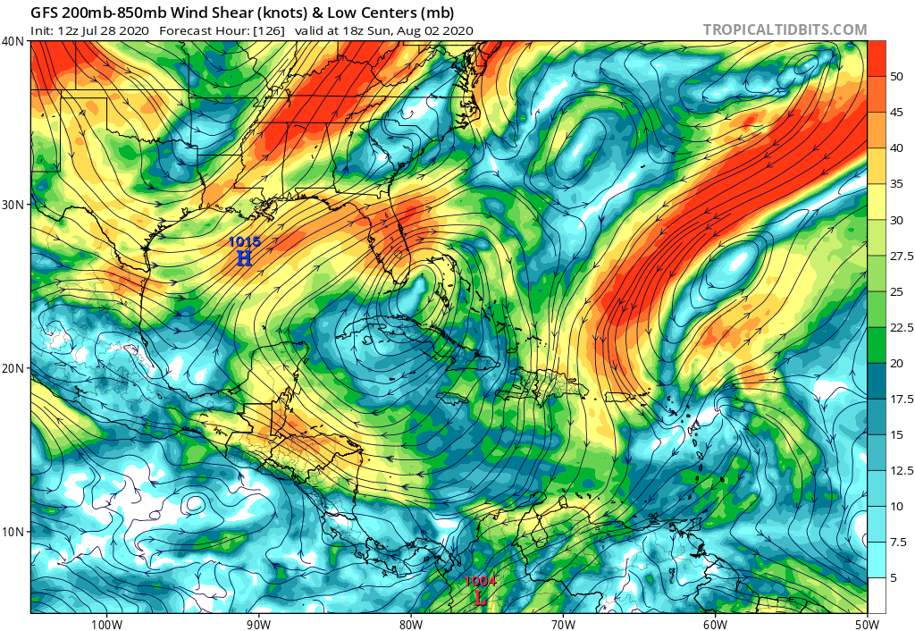
Hypercane_Kyle wrote:TheStormExpert wrote:gatorcane wrote:
Yet the model shows a very favorable upper-level wind pattern that sets up as it approaches SE Florida. Hot water, slow moving, system. Hmmm...
https://i.postimg.cc/L4vgxfHT/gfs-shear-watl-22.png
Dry air.
https://i.ibb.co/56sqB9k/gfs-mid-RH-watl-22.png
Appears to be so. I can tell you I've never seen dry air kill a storm completely near Florida in late-July.
NDG said this dry air is to be expected but there’s seems to be a lot more throughout the basin and it’s more dense, same with SAL.
0 likes
-
TheStormExpert
Re: ATL: NINE - Models
WeatherEmperor wrote:Aaaaaaand it starts turning NW looking to just miss Florida to the east. How many times have we seen this before?
https://uploads.tapatalk-cdn.com/20200728/2e70d2f7e525c11a5fc7bdbc7de1b0b2.jpg
Sent from my iPhone using Tapatalk
Metropolitan SE Florida must have some great hurricane repellent on!
The same stuff that’s spared Hawaii multiple times in the last six years.
5 likes
-
SouthFLTropics
- Category 5
- Posts: 4258
- Age: 50
- Joined: Thu Aug 14, 2003 8:04 am
- Location: Port St. Lucie, Florida
Re: ATL: NINE - Models
Looks like a big slow down in forward speed on the HWRF when it gets to the NW Bahamas. Once again we wait. I wouldn't put much stock in any strength or track until it gets clear of Hispaniola. Once we see how that will play out then we can get a better idea of where this is going and what it will be when it gets there.
4 likes
Fourth Generation Florida Native
Personal Storm History: David 79, Andrew 92, Erin 95, Floyd 99, Irene 99, Frances 04, Jeanne 04, Wilma 05, Matthew 16, Irma 17, Ian 22, Nicole 22, Milton 24
Personal Storm History: David 79, Andrew 92, Erin 95, Floyd 99, Irene 99, Frances 04, Jeanne 04, Wilma 05, Matthew 16, Irma 17, Ian 22, Nicole 22, Milton 24
-
SouthFLTropics
- Category 5
- Posts: 4258
- Age: 50
- Joined: Thu Aug 14, 2003 8:04 am
- Location: Port St. Lucie, Florida
Re: ATL: NINE - Models
TheStormExpert wrote:WeatherEmperor wrote:Aaaaaaand it starts turning NW looking to just miss Florida to the east. How many times have we seen this before?
https://uploads.tapatalk-cdn.com/20200728/2e70d2f7e525c11a5fc7bdbc7de1b0b2.jpg
Sent from my iPhone using Tapatalk
Metropolitan SE Florida must have some great hurricane repellent on!
The same stuff that’s spared Hawaii multiple times in the last six years.
It's jLauderdale's generator force field. The HWRF took it into account.
6 likes
Fourth Generation Florida Native
Personal Storm History: David 79, Andrew 92, Erin 95, Floyd 99, Irene 99, Frances 04, Jeanne 04, Wilma 05, Matthew 16, Irma 17, Ian 22, Nicole 22, Milton 24
Personal Storm History: David 79, Andrew 92, Erin 95, Floyd 99, Irene 99, Frances 04, Jeanne 04, Wilma 05, Matthew 16, Irma 17, Ian 22, Nicole 22, Milton 24
-
Shell Mound
- Category 5
- Posts: 2432
- Age: 33
- Joined: Thu Sep 07, 2017 3:39 pm
- Location: St. Petersburg, FL → Scandinavia
Re: ATL: NINE - Models
TheStormExpert wrote:WeatherEmperor wrote:Aaaaaaand it starts turning NW looking to just miss Florida to the east. How many times have we seen this before?
https://uploads.tapatalk-cdn.com/20200728/2e70d2f7e525c11a5fc7bdbc7de1b0b2.jpg
Sent from my iPhone using Tapatalk
Metropolitan SE Florida must have some great hurricane repellent on!
The same stuff that’s spared Hawaii multiple times in the last six years.
Don’t tempt 2020. Please. Sooner or later people will be shocked—and not in a good way. We’ve seen too many close calls within the past three years.
Last edited by Shell Mound on Tue Jul 28, 2020 12:57 pm, edited 1 time in total.
3 likes
CVW / MiamiensisWx / Shell Mound
The posts in this forum are NOT official forecasts and should not be used as such. They are just the opinion of the poster and may or may not be backed by sound meteorological data. They are NOT endorsed by any professional institution or STORM2K. For official information, please refer to products from the NHC and NWS.
-
supercane4867
- Category 5
- Posts: 4966
- Joined: Wed Nov 14, 2012 10:43 am
Re: ATL: NINE - Models
The upcoming HWRF replacement is SW and weaker of the operational runs.

Landfall on Miami as a CAT1 @ 117hr
Landfall on Miami as a CAT1 @ 117hr
0 likes
-
SouthFLTropics
- Category 5
- Posts: 4258
- Age: 50
- Joined: Thu Aug 14, 2003 8:04 am
- Location: Port St. Lucie, Florida
Re: ATL: NINE - Models
That HWRF Para run still brings a Cat 1 into Miami-Dade and Broward.
2 likes
Fourth Generation Florida Native
Personal Storm History: David 79, Andrew 92, Erin 95, Floyd 99, Irene 99, Frances 04, Jeanne 04, Wilma 05, Matthew 16, Irma 17, Ian 22, Nicole 22, Milton 24
Personal Storm History: David 79, Andrew 92, Erin 95, Floyd 99, Irene 99, Frances 04, Jeanne 04, Wilma 05, Matthew 16, Irma 17, Ian 22, Nicole 22, Milton 24
-
Blown Away
- S2K Supporter
- Posts: 10253
- Joined: Wed May 26, 2004 6:17 am
Re: ATL: NINE - Models

12z HWRF... Slightly E of 00z and moves through the Central Bahamas... Initially stronger than 00z but finishes slightly weaker...
0 likes
Hurricane Eye Experience: David 79, Irene 99, Frances 04, Jeanne 04, Wilma 05… Hurricane Brush Experience: Andrew 92, Erin 95, Floyd 99, Matthew 16, Irma 17, Ian 22, Nicole 22…
-
SouthFLTropics
- Category 5
- Posts: 4258
- Age: 50
- Joined: Thu Aug 14, 2003 8:04 am
- Location: Port St. Lucie, Florida
Re: ATL: NINE - Models
12z Euro is running...
0 likes
Fourth Generation Florida Native
Personal Storm History: David 79, Andrew 92, Erin 95, Floyd 99, Irene 99, Frances 04, Jeanne 04, Wilma 05, Matthew 16, Irma 17, Ian 22, Nicole 22, Milton 24
Personal Storm History: David 79, Andrew 92, Erin 95, Floyd 99, Irene 99, Frances 04, Jeanne 04, Wilma 05, Matthew 16, Irma 17, Ian 22, Nicole 22, Milton 24
-
Shell Mound
- Category 5
- Posts: 2432
- Age: 33
- Joined: Thu Sep 07, 2017 3:39 pm
- Location: St. Petersburg, FL → Scandinavia
Re: ATL: NINE - Models
WeatherEmperor wrote:Aaaaaaand it starts turning NW looking to just miss Florida to the east. How many times have we seen this before?
https://uploads.tapatalk-cdn.com/20200728/2e70d2f7e525c11a5fc7bdbc7de1b0b2.jpg
Sent from my iPhone using Tapatalk
Bear in mind that the HWRF is based in part on NCEP’s G(E)FS and likely significantly underestimates the strength and westward extension of the WAR (Western Atlantic Ridge) by days five and six. The past six runs of the EPS have shown a significantly stronger WAR than the GEFS, the latter of which is actually trending toward the EPS but is still catching up. I would not assume that a stronger system will necessarily miss FL, given that the GEFS and its offshoots are notorious for underestimating ridge extensions during highly amplified patterns.
4 likes
CVW / MiamiensisWx / Shell Mound
The posts in this forum are NOT official forecasts and should not be used as such. They are just the opinion of the poster and may or may not be backed by sound meteorological data. They are NOT endorsed by any professional institution or STORM2K. For official information, please refer to products from the NHC and NWS.
Who is online
Users browsing this forum: No registered users and 13 guests