ATL: CRISTOBAL - Models
Moderator: S2k Moderators

Re: ATL: CRISTOBAL - Models
Right, that's why I had "at different levels". The existing LLC may or may not be what ends up being the ultimate focusing mechanism.
2 likes
Re: ATL: CRISTOBAL - Models
GFS down to 990 in 24 hours (7am tomorrow) roughly 24.6N / 89.6W. Isobars are a little oval but mostly concentric. That means a cool looking system if the GFS is right.
https://www.tropicaltidbits.com/analysi ... 0512&fh=24
989 (so not really intensifying) at 36 hours roughly 26.0N / 89.7W so moving just a little west of due north
https://www.tropicaltidbits.com/analysi ... 0512&fh=36
990mb at 27.5N / 90.0W at 48 hours.
https://www.tropicaltidbits.com/analysi ... 0512&fh=48
990mb at 28.5N / 90.05W at 54 hours
https://www.tropicaltidbits.com/analysi ... 0512&fh=54
0 likes

Re: ATL: CRISTOBAL - Models
Steve wrote:GFS down to 990 in 24 hours (7am tomorrow) roughly 24.6N / 89.6W. Isobars are a little oval but mostly concentric. That means a cool looking system if the GFS is right.
https://www.tropicaltidbits.com/analysi ... 0512&fh=24
989 (so not really intensifying) at 36 hours roughly 26.0N / 89.7W so moving just a little west of due north
https://www.tropicaltidbits.com/analysi ... 0512&fh=36
990mb at 27.5N / 90.0W at 48 hours.
https://www.tropicaltidbits.com/analysi ... 0512&fh=48
990mb at 28.5N / 90.05W at 54 hours
https://www.tropicaltidbits.com/analysi ... 0512&fh=54
Wow that’s a lot of rain for eastern LA and Southern MS
0 likes
Re: ATL: CRISTOBAL - Models
Landfall about 60 hours @ Grand Isle 7pm Sunday night.
https://www.tropicaltidbits.com/analysi ... 0512&fh=60
https://www.tropicaltidbits.com/analysi ... 0512&fh=60
0 likes
-
MississippiWx

- S2K Supporter

- Posts: 1535
- Joined: Sat Aug 14, 2010 1:44 pm
- Location: Hattiesburg, Mississippi
Re: ATL: CRISTOBAL - Models
GFS continues with a stronger landfall possibility. The storm is not as broad and much more TC-like.
0 likes
This post is not an official forecast and should not be used as such. It is just the opinion of MississippiWx and may or may not be backed by sound meteorological data. It is not endorsed by any professional institution including storm2k.org. For Official Information please refer to the NHC and NWS products.
Re: ATL: CRISTOBAL - Models
bella_may wrote:Steve wrote:GFS down to 990 in 24 hours (7am tomorrow) roughly 24.6N / 89.6W. Isobars are a little oval but mostly concentric. That means a cool looking system if the GFS is right.
https://www.tropicaltidbits.com/analysi ... 0512&fh=24
989 (so not really intensifying) at 36 hours roughly 26.0N / 89.7W so moving just a little west of due north
https://www.tropicaltidbits.com/analysi ... 0512&fh=36
990mb at 27.5N / 90.0W at 48 hours.
https://www.tropicaltidbits.com/analysi ... 0512&fh=48
990mb at 28.5N / 90.05W at 54 hours
https://www.tropicaltidbits.com/analysi ... 0512&fh=54
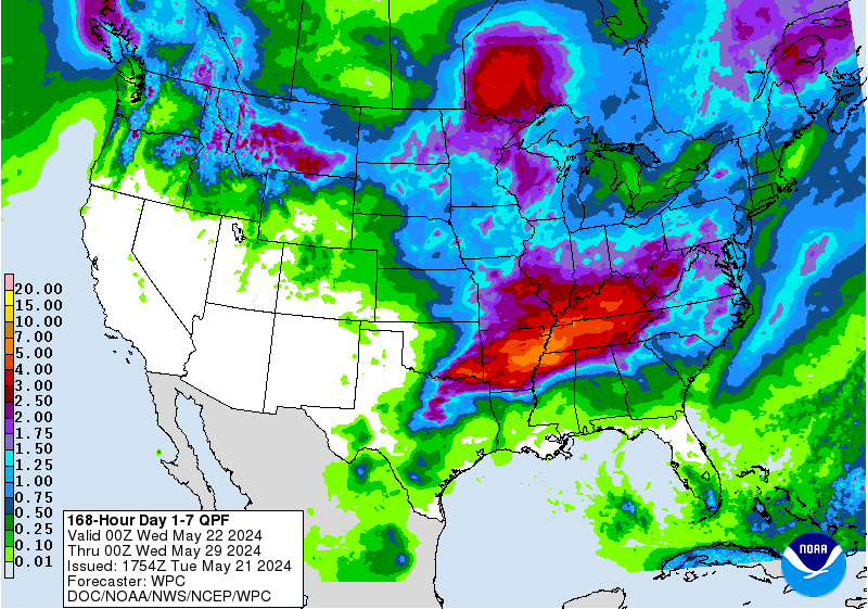
Wow that’s a lot of rain for eastern LA and Southern MS
Oddly enough, GFS doesn't paint that much rain in. The 12z QPF has a lot of 5-7" which is way more than the GFS was showing though you already know there will be locally heavier amounts.
https://www.wpc.ncep.noaa.gov/qpf/p168i.gif?1591372247
0 likes
-
Dean4Storms
- S2K Supporter
- Posts: 6355
- Age: 61
- Joined: Sun Aug 31, 2003 1:01 pm
- Location: Miramar Bch. FL
Re: ATL: CRISTOBAL - Models
Some aspects of that GFS run makes no sense, it actually shrinks the size of the wind field and not much rain for the AL and FL Panhandle Coasts. Call me confused.
0 likes

Re: ATL: CRISTOBAL - Models
For it to make landfall Sunday night, it would have to be really moving, I think Monday around 10am would be more of a realistic time frame, but the faster the better. So hopefully these models are correct with Sunday night.
1 likes
Personal Forecast Disclaimer:
The posts in this forum are NOT official forecast and should not be used as such. They are just the opinion of the poster and may or may not be backed by sound meteorological data. They are NOT endorsed by any professional institution or storm2k.org. For official information, please refer to the NHC and NWS products.
The posts in this forum are NOT official forecast and should not be used as such. They are just the opinion of the poster and may or may not be backed by sound meteorological data. They are NOT endorsed by any professional institution or storm2k.org. For official information, please refer to the NHC and NWS products.
Re: ATL: CRISTOBAL - Models
12Z Icon comes in late Sunday night about 992mb a little west of the GFS and moves a bit west still up toward Shreveport. ICON doesn't show that much rain either though it's got a bit more than the GFS.
https://www.tropicaltidbits.com/analysi ... 0512&fh=72
CMC is running now out to 6 hours.
https://www.tropicaltidbits.com/analysi ... 0512&fh=72
CMC is running now out to 6 hours.
Last edited by Steve on Fri Jun 05, 2020 11:04 am, edited 1 time in total.
0 likes
-
MississippiWx
- S2K Supporter
- Posts: 1535
- Joined: Sat Aug 14, 2010 1:44 pm
- Location: Hattiesburg, Mississippi
Re: ATL: CRISTOBAL - Models
Dean4Storms wrote:Some aspects of that GFS run makes no sense, it actually shrinks the size of the wind field and not much rain for the AL and FL Panhandle Coasts. Call me confused.
That’s because it’s seeing a tighter system. Notice how the 850mb vort has trended stronger each run. I think models have underestimated the strength of the center coming off the Yucatán.
0 likes
This post is not an official forecast and should not be used as such. It is just the opinion of MississippiWx and may or may not be backed by sound meteorological data. It is not endorsed by any professional institution including storm2k.org. For Official Information please refer to the NHC and NWS products.
-
Aric Dunn
- Category 5

- Posts: 21228
- Age: 41
- Joined: Sun Sep 19, 2004 9:58 pm
- Location: Ready for the Chase.
- Contact:
Re: ATL: CRISTOBAL - Models
I do like the GFS's 6 hour position. it is spot on to what we are seeing right now. off the North central coast
1 likes
Note: If I make a post that is brief. Please refer back to previous posts for the analysis or reasoning. I do not re-write/qoute what my initial post said each time.
If there is nothing before... then just ask
Space & Atmospheric Physicist, Embry-Riddle Aeronautical University,
I believe the sky is falling...
If there is nothing before... then just ask
Space & Atmospheric Physicist, Embry-Riddle Aeronautical University,
I believe the sky is falling...
-
Aric Dunn
- Category 5
- Posts: 21228
- Age: 41
- Joined: Sun Sep 19, 2004 9:58 pm
- Location: Ready for the Chase.
- Contact:
Re: ATL: CRISTOBAL - Models
it starts to gets its act together right at landfall. it cuts off from the dry air and shear drops.

1 likes
Note: If I make a post that is brief. Please refer back to previous posts for the analysis or reasoning. I do not re-write/qoute what my initial post said each time.
If there is nothing before... then just ask
Space & Atmospheric Physicist, Embry-Riddle Aeronautical University,
I believe the sky is falling...
If there is nothing before... then just ask
Space & Atmospheric Physicist, Embry-Riddle Aeronautical University,
I believe the sky is falling...
-
Stormcenter
- S2K Supporter
- Posts: 6617
- Joined: Wed Sep 03, 2003 11:27 am
- Location: Houston, TX
Re: ATL: CRISTOBAL - Models
I agree.
MississippiWx wrote:Dean4Storms wrote:Some aspects of that GFS run makes no sense, it actually shrinks the size of the wind field and not much rain for the AL and FL Panhandle Coasts. Call me confused.
That’s because it’s seeing a tighter system. Notice how the 850mb vort has trended stronger each run. I think models have underestimated the strength of the center coming off the Yucatán.
0 likes
Re: ATL: CRISTOBAL - Models
CMC is a little different still so that's 3 models close but not exactly the same. CMC landfalls a little earlier than the GFS (Sunday afternoon) and maybe a hair more east toward Grand Isle. It too does not have that much rainfall, though Dean4Storms will appreciate this one more because the focus line of nearly a foot of rain is across Bay and Walton Counties with another spot around Pensacola. This is through 72 hours:
https://www.tropicaltidbits.com/analysi ... 0512&fh=72
https://www.tropicaltidbits.com/analysi ... 0512&fh=72
0 likes
Re: ATL: CRISTOBAL - Models
HMON and HWRF are running now. It's nice when you only have to wait for a few plots instead of waiting for 144 hours worth of plots.
Thing about the HWRF and HMON is that they both have the center west of the Yucatan in 6 hours. If the center Aric has been showing ends up being the center to track, these will be out to lunch at least for the first part of the runs. They might end up at the right place or whatever, but they might have to be thrown away.
Thing about the HWRF and HMON is that they both have the center west of the Yucatan in 6 hours. If the center Aric has been showing ends up being the center to track, these will be out to lunch at least for the first part of the runs. They might end up at the right place or whatever, but they might have to be thrown away.
1 likes
-
Dean4Storms
- S2K Supporter
- Posts: 6355
- Age: 61
- Joined: Sun Aug 31, 2003 1:01 pm
- Location: Miramar Bch. FL
Re: ATL: CRISTOBAL - Models
Steve wrote:CMC is a little different still so that's 3 models close but not exactly the same. CMC landfalls a little earlier than the GFS (Sunday afternoon) and maybe a hair more east toward Grand Isle. It too does not have that much rainfall, though Dean4Storms will appreciate this one more because the focus line of nearly a foot of rain is across Bay and Walton Counties with another spot around Pensacola. This is through 72 hours:
https://www.tropicaltidbits.com/analysi ... 0512&fh=72
We do need the rain but working at a resort golf course we don't want too much. I'd be happy if it is over rain wise for us come Monday.
1 likes

Re: ATL: CRISTOBAL - Models
Two runs in a row now that the GFS paints a better environment over the northern GOM.
Becoming extra-tropical like some thought might happen is probably down to 1% if not 0


Becoming extra-tropical like some thought might happen is probably down to 1% if not 0
6 likes
Re: ATL: CRISTOBAL - Models
HWRF landfalls Vermilion Bay Sunday around noon. It's been erratic and is again probably a little too fast.
https://www.tropicaltidbits.com/analysi ... 0512&fh=51
https://www.tropicaltidbits.com/analysi ... 0512&fh=51
0 likes
Re: ATL: CRISTOBAL - Models
HMON comes in slightly east of New Orleans. Otherwise, the timing is about 7pm Sunday evening.
https://www.tropicaltidbits.com/analysi ... 0512&fh=60
Next up, the European.
https://www.tropicaltidbits.com/analysi ... 0512&fh=60
Next up, the European.
0 likes

Re: ATL: CRISTOBAL - Models
NDG wrote:Two runs in a row now that the GFS paints a better environment over the northern GOM.
Becoming extra-tropical like some thought might happen is probably down to 1% if not 0
https://i.imgur.com/r6LRx80.gif
https://i.imgur.com/x56f8jU.png
https://i.imgur.com/hsZN7RE.png
Hmm, not too bad. Overall shear should be reduced by Cristobal traveling in the same direction as the winds, and it seems to develop a nice pocket of moist air. I still think it’ll end up as a 50-60 kt TS with an appearance that’s a blend of Cindy ‘05 and Alberto ‘18.
1 likes
Irene '11 Sandy '12 Hermine '16 5/15/2018 Derecho Fay '20 Isaias '20 Elsa '21 Henri '21 Ida '21
I am only a meteorology enthusiast who knows a decent amount about tropical cyclones. Look to the professional mets, the NHC, or your local weather office for the best information.
I am only a meteorology enthusiast who knows a decent amount about tropical cyclones. Look to the professional mets, the NHC, or your local weather office for the best information.
Who is online
Users browsing this forum: No registered users and 19 guests