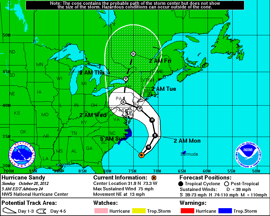
ATL: FAY - Post-Tropical - Discussion

Moderator: S2k Moderators

Message
Author
User avatar
aspen
Category 5
Category 5
Posts: 8057
Joined: Sat Oct 12, 2019 7:10 pm
Location: Connecticut, USA

Re: ATL: FAY - Tropical Storm - Discussion

#401 Postby aspen » Thu Jul 09, 2020 7:15 pm

Steve wrote:
aspen wrote:Didn’t Andrea ‘13 make it up here fully tropical? I only vaguely remember it.


Haha. That’s most of them.

2013 was also the first season I tracked...what a great year to get into hurricane tracking lol. The only systems I clearly remembered are Andrea (got up to the NE US), Humberto (became a hurricane before dissipating and regenerating), and Karen (prime example of how everything just failed that season).

On the subject of Fay, it looks like convection is starting to spread over the center some more.
3 likes   
Irene '11 Sandy '12 Hermine '16 5/15/2018 Derecho Fay '20 Isaias '20 Elsa '21 Henri '21 Ida '21

I am only a meteorology enthusiast who knows a decent amount about tropical cyclones. Look to the professional mets, the NHC, or your local weather office for the best information.

User avatar
Yellow Evan
Professional-Met
Professional-Met
Posts: 15952
Age: 25
Joined: Fri Jul 15, 2011 12:48 pm
Location: Henderson, Nevada/Honolulu, HI
Contact:

Re: ATL: FAY - Tropical Storm - Discussion

#402 Postby Yellow Evan » Thu Jul 09, 2020 7:23 pm

09/2331 UTC 36.1N 74.7W T3.0/3.0 FAY -- Atlantic
1 likes   

User avatar
ouragans
Category 1
Category 1
Posts: 465
Age: 52
Joined: Sun Jun 12, 2011 12:09 pm
Location: Abymes, Guadeloupe F.W.I
Contact:

Re: ATL: FAY - Tropical Storm - Discussion

#403 Postby ouragans » Thu Jul 09, 2020 7:30 pm

gfsperpendicular wrote:
ouragans wrote:
Hurricanehink wrote:
9 years? (Irene)

Sandy 2012


Sandy wasn't tropical upon landfall. Technically didn't really "hit" NYC like Irene or forecasted Fay either, but the RMW was so massive it didn't really matter.

The question was "tropical forecast to hit NYC" and Sandy was. It did not reach NYC as a TC, but was forecast to
2 likes   
Personal forecast disclaimer
This post is a personal point of view, not an information. Please refer to official statements for life-threatening decisions.

David '79, Frederic '79, Hugo '89, Iris, Luis & Marilyn '95, Georges '98, Lenny '99, Dean '07, Irma '17, Maria '17, Fiona '22, Philippe '23, Tammy '23
16°13'33.3,"6N -61°36'39.5"W

User avatar
Ubuntwo
Category 5
Category 5
Posts: 1089
Age: 30
Joined: Thu Oct 05, 2017 10:41 pm

Re: ATL: FAY - Tropical Storm - Discussion

#404 Postby Ubuntwo » Thu Jul 09, 2020 7:48 pm

ouragans wrote:
gfsperpendicular wrote:
ouragans wrote:Sandy 2012


Sandy wasn't tropical upon landfall. Technically didn't really "hit" NYC like Irene or forecasted Fay either, but the RMW was so massive it didn't really matter.

The question was "tropical forecast to hit NYC" and Sandy was. It did not reach NYC as a TC, but was forecast to

The forecast was never over NYC, though. At one point they had a track over Delmarva, at others New Jersey.
0 likes   
Kendall -> SLO -> PBC

Memorable Storms: Katrina (for its Florida landfall...) Wilma Matthew Irma

User avatar
gfsperpendicular
Category 1
Category 1
Posts: 383
Age: 19
Joined: Mon Jun 19, 2017 3:04 pm
Location: Northern Virginia

Re: ATL: FAY - Tropical Storm - Discussion

#405 Postby gfsperpendicular » Thu Jul 09, 2020 8:05 pm

Ubuntwo wrote:
ouragans wrote:
gfsperpendicular wrote:
Sandy wasn't tropical upon landfall. Technically didn't really "hit" NYC like Irene or forecasted Fay either, but the RMW was so massive it didn't really matter.

The question was "tropical forecast to hit NYC" and Sandy was. It did not reach NYC as a TC, but was forecast to

The forecast was never over NYC, though. At one point they had a track over Delmarva, at others New Jersey.

Yeah, Sandy's forecast track was pretty consistent and verified pretty well. Here's the closest it got to having a forecasted track over NYC:

Image
0 likes   
I'm not sleeping, I'm waiting for the 0900 UTC advisory!

#1 CMC stan

Aric Dunn
Category 5
Category 5
Posts: 21228
Age: 41
Joined: Sun Sep 19, 2004 9:58 pm
Location: Ready for the Chase.
Contact:

Re: ATL: FAY - Tropical Storm - Discussion

#406 Postby Aric Dunn » Thu Jul 09, 2020 8:06 pm

You know I always thought there were a lot more buoys up this way.. lol

myabe they are just hiding...
2 likes   
Note: If I make a post that is brief. Please refer back to previous posts for the analysis or reasoning. I do not re-write/qoute what my initial post said each time.
If there is nothing before... then just ask :)

Space & Atmospheric Physicist, Embry-Riddle Aeronautical University,
I believe the sky is falling...

floridasun78
Category 5
Category 5
Posts: 3755
Joined: Sun May 17, 2009 10:16 pm
Location: miami fl

Re: ATL: FAY - Tropical Storm - Discussion

#407 Postby floridasun78 » Thu Jul 09, 2020 8:13 pm

nice area in Bahama look is tail of fay we have see if get pull into fay or stay in Bahama area
0 likes   

User avatar
Steve
S2K Supporter
S2K Supporter
Posts: 8606
Joined: Sat Apr 05, 2003 11:41 pm
Location: Not a state-caster

Re: ATL: FAY - Tropical Storm - Discussion

#408 Postby Steve » Thu Jul 09, 2020 8:22 pm

aspen wrote:
Steve wrote:
aspen wrote:Didn’t Andrea ‘13 make it up here fully tropical? I only vaguely remember it.


Haha. That’s most of them.

2013 was also the first season I tracked...what a great year to get into hurricane tracking lol. The only systems I clearly remembered are Andrea (got up to the NE US), Humberto (became a hurricane before dissipating and regenerating), and Karen (prime example of how everything just failed that season).

On the subject of Fay, it looks like convection is starting to spread over the center some more.


I go back to Betsy in 1965 but I was only 1. Camille at 5. Then it was few and far between until a couple brush by’s in 84, Juan in 85 and finally 1988. Once we got out of the -amo, it’s been a ton more action.

00Z HRRR spikes Maryland for a second or two but is in a down-pulse at NJ. It’s done a good job in a general sense as has the ICON. HRRR is always near term but you don’t often have the ICON in an alliance of the best models for a given storm. Those were the two that kept it in the water whereas most other models hugged or rode the coast inland.

https://www.tropicaltidbits.com/analysi ... 71000&fh=1

Anyway, maybe people more inland NY State would get the following pulse up more so than around landfall.
0 likes   

Aric Dunn
Category 5
Category 5
Posts: 21228
Age: 41
Joined: Sun Sep 19, 2004 9:58 pm
Location: Ready for the Chase.
Contact:

Re: ATL: FAY - Tropical Storm - Discussion

#409 Postby Aric Dunn » Thu Jul 09, 2020 8:24 pm

Well it just crossed over into a pocket of low to mid 70s water.

seems to be doing just fine. actually deepening..
1 likes   
Note: If I make a post that is brief. Please refer back to previous posts for the analysis or reasoning. I do not re-write/qoute what my initial post said each time.
If there is nothing before... then just ask :)

Space & Atmospheric Physicist, Embry-Riddle Aeronautical University,
I believe the sky is falling...

Aric Dunn
Category 5
Category 5
Posts: 21228
Age: 41
Joined: Sun Sep 19, 2004 9:58 pm
Location: Ready for the Chase.
Contact:

Re: ATL: FAY - Tropical Storm - Discussion

#410 Postby Aric Dunn » Thu Jul 09, 2020 9:16 pm

if the direction of the shear changes a little more out of the south.. and it is producing this much convection over marginal water.. could be a bit more of a problem..
1 likes   
Note: If I make a post that is brief. Please refer back to previous posts for the analysis or reasoning. I do not re-write/qoute what my initial post said each time.
If there is nothing before... then just ask :)

Space & Atmospheric Physicist, Embry-Riddle Aeronautical University,
I believe the sky is falling...

ozonepete
Professional-Met
Professional-Met
Posts: 4743
Joined: Mon Sep 07, 2009 3:23 pm
Location: From Ozone Park, NYC / Now in Brooklyn, NY

Re: ATL: FAY - Tropical Storm - Discussion

#411 Postby ozonepete » Thu Jul 09, 2020 9:40 pm

Aric Dunn wrote:if the direction of the shear changes a little more out of the south.. and it is producing this much convection over marginal water.. could be a bit more of a problem..


Convection remains impressive. A lot of lightning in the core...
2 likes   

Aric Dunn
Category 5
Category 5
Posts: 21228
Age: 41
Joined: Sun Sep 19, 2004 9:58 pm
Location: Ready for the Chase.
Contact:

Re: ATL: FAY - Tropical Storm - Discussion

#412 Postby Aric Dunn » Thu Jul 09, 2020 9:45 pm

ozonepete wrote:
Aric Dunn wrote:if the direction of the shear changes a little more out of the south.. and it is producing this much convection over marginal water.. could be a bit more of a problem..


Convection remains impressive. A lot of lightning in the core...


yeah, though the center is still partially exposed. but if the angle of the shear changes things may get interesting.
1 likes   
Note: If I make a post that is brief. Please refer back to previous posts for the analysis or reasoning. I do not re-write/qoute what my initial post said each time.
If there is nothing before... then just ask :)

Space & Atmospheric Physicist, Embry-Riddle Aeronautical University,
I believe the sky is falling...

User avatar
Steve
S2K Supporter
S2K Supporter
Posts: 8606
Joined: Sat Apr 05, 2003 11:41 pm
Location: Not a state-caster

Re: ATL: FAY - Tropical Storm - Discussion

#413 Postby Steve » Thu Jul 09, 2020 10:48 pm

You kind of have to throw it up for Fay. It consisted of some spins in the Gulf, went across Cape San Blas and in and across the SE and is on it’s way to some of the big cities. I just can’t get away from the idea that this kind of a track with something real is about worst case ever.
3 likes   

Shell Mound
Category 5
Category 5
Posts: 2434
Age: 31
Joined: Thu Sep 07, 2017 3:39 pm
Location: St. Petersburg, FL → Scandinavia

Re: ATL: FAY - Tropical Storm - Discussion

#414 Postby Shell Mound » Thu Jul 09, 2020 10:52 pm

0 likes   
CVW / MiamiensisWx / Shell Mound
The posts in this forum are NOT official forecasts and should not be used as such. They are just the opinion of the poster and may or may not be backed by sound meteorological data. They are NOT endorsed by any professional institution or STORM2K. For official information, please refer to products from the NHC and NWS.

User avatar
EquusStorm
Category 5
Category 5
Posts: 1649
Age: 33
Joined: Thu Nov 07, 2013 1:04 pm
Location: Jasper, AL
Contact:

Re: ATL: FAY - Tropical Storm - Discussion

#415 Postby EquusStorm » Thu Jul 09, 2020 11:46 pm

That's a very solid convective core. I expected an entirely east-loaded raggedy system with broad, exposed centers hanging out west of the convection but this looks pretty well organized on satellite and radar both. Very impressive.
0 likes   
Colors of lost purpose on the canvas of irrelevance

Not a meteorologist, in fact more of an idiot than anything. You should probably check with the NHC or a local NWS office for official information.

NXStumpy_Robothing
Category 1
Category 1
Posts: 325
Age: 23
Joined: Fri Jun 05, 2020 11:50 pm
Location: North Georgia

Re: ATL: FAY - Tropical Storm - Discussion

#416 Postby NXStumpy_Robothing » Thu Jul 09, 2020 11:59 pm

EquusStorm wrote:That's a very solid convective core. I expected an entirely east-loaded raggedy system with broad, exposed centers hanging out west of the convection but this looks pretty well organized on satellite and radar both. Very impressive.

To be fair, that's the MLC that has been boosting a lot of the convection; the LLC is still to the SW of most of the convection, though some is building on the eastern side of that circulation. The storm is still tilted, but it still looks pretty impressive despite that.
0 likes   
Undergraduate Meteorology Student, Georgia Institute of Technology

User avatar
EquusStorm
Category 5
Category 5
Posts: 1649
Age: 33
Joined: Thu Nov 07, 2013 1:04 pm
Location: Jasper, AL
Contact:

Re: ATL: FAY - Tropical Storm - Discussion

#417 Postby EquusStorm » Fri Jul 10, 2020 12:23 am

Wonder if it gets the chance to stack vertically. Clock's ticking for more organization seeing as it'll probably come ashore in a day
0 likes   
Colors of lost purpose on the canvas of irrelevance

Not a meteorologist, in fact more of an idiot than anything. You should probably check with the NHC or a local NWS office for official information.

User avatar
GCANE
S2K Supporter
S2K Supporter
Posts: 10787
Joined: Mon Oct 22, 2007 8:03 am

Re: ATL: FAY - Tropical Storm - Discussion

#418 Postby GCANE » Fri Jul 10, 2020 3:32 am

Its still trying to keep itself organized.
Strong helicity still remains in the convection.
Good pressure drop between recon passes.
That huge injection of moisture from the fractured tropical wave did the trick.


Image

Image
1 likes   

User avatar
GCANE
S2K Supporter
S2K Supporter
Posts: 10787
Joined: Mon Oct 22, 2007 8:03 am

Re: ATL: FAY - Tropical Storm - Discussion

#419 Postby GCANE » Fri Jul 10, 2020 3:41 am

Interesing feature.
A breakoff 925mb vort off the FL east coast with high-helicity and deep convection.
Watching if this refires.

Image

0 likes   

User avatar
GCANE
S2K Supporter
S2K Supporter
Posts: 10787
Joined: Mon Oct 22, 2007 8:03 am

Re: ATL: FAY - Tropical Storm - Discussion

#420 Postby GCANE » Fri Jul 10, 2020 3:55 am

00Z GFS is showing that fractured vort remaining off the SE coast for 72 hrs

Image
0 likes   


Return to “2020”

Who is online

Users browsing this forum: No registered users and 89 guests