ATL: ISAIAS - Models

Moderator: S2k Moderators

Message
Author
User avatar
DestinHurricane
Category 4
Category 4
Posts: 930
Joined: Tue May 01, 2018 8:05 am
Location: Columbus, OH... need to get back in the action

Re: ATL: ISAIAS - Models

#2401 Postby DestinHurricane » Sat Aug 01, 2020 5:02 pm

Blown Away wrote:
Steve wrote:GFS looks to briefly cross the shore. We'll see what it does after
https://www.tropicaltidbits.com/analysi ... 0118&fh=12


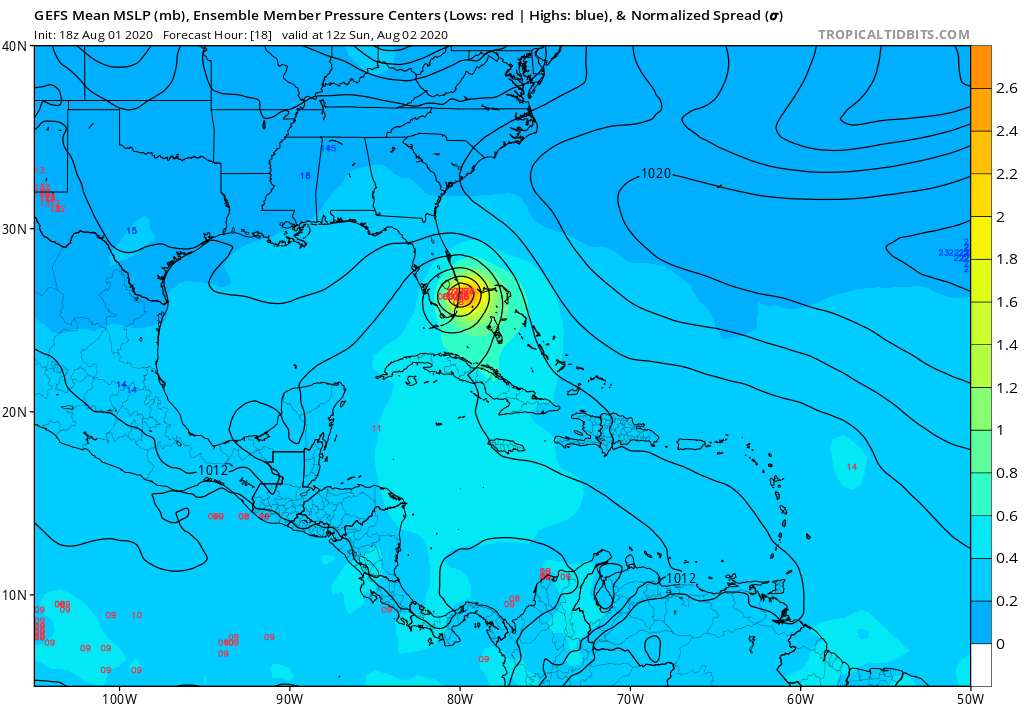
Yeah, 18z GFS slightly W through 30 hours with landfall near Pt St Lucie and I noticed it’s showing a much moister environment around Isaias through 30 hours...


Landfall looks south of PSL to me, looks like palm beach. https://weather.us/model-charts/standar ... 1200z.html
0 likes   
Destin/Santa Rosa Beach, Florida: Ivan 2004, Dennis 2005, Michael 2018, Sally 2020

Fort Lauderdale, Florida Eta 2020, Many future storms!

THE Ohio State University: :cold:

User avatar
Steve
S2K Supporter
S2K Supporter
Posts: 8606
Joined: Sat Apr 05, 2003 11:41 pm
Location: Not a state-caster

Re: ATL: ISAIAS - Models

#2402 Postby Steve » Sat Aug 01, 2020 5:15 pm

Here's a cool twist from the HRRR 21z at 1am. Isaias takes a jab at Palm Beach County. Take that.

Image
1 likes   

User avatar
cheezyWXguy
Category 5
Category 5
Posts: 5536
Joined: Mon Feb 13, 2006 12:29 am
Location: Dallas, TX

Re: ATL: ISAIAS - Models

#2403 Postby cheezyWXguy » Sat Aug 01, 2020 5:17 pm

Since this new burst is on the north side of the circulation, is there a possibility that the convection might pull the center northward into it? If so, I would imagine that would have some minor implications on landfall location.
1 likes   

User avatar
DestinHurricane
Category 4
Category 4
Posts: 930
Joined: Tue May 01, 2018 8:05 am
Location: Columbus, OH... need to get back in the action

Re: ATL: ISAIAS - Models

#2404 Postby DestinHurricane » Sat Aug 01, 2020 5:19 pm

cheezyWXguy wrote:Since this new burst is on the north side of the circulation, is there a possibility that the convection might pull the center northward into it? If so, I would imagine that would have some minor implications on landfall location.


Seems to have already happened. Could still jog back west though.
2 likes   
Destin/Santa Rosa Beach, Florida: Ivan 2004, Dennis 2005, Michael 2018, Sally 2020

Fort Lauderdale, Florida Eta 2020, Many future storms!

THE Ohio State University: :cold:

User avatar
Steve
S2K Supporter
S2K Supporter
Posts: 8606
Joined: Sat Apr 05, 2003 11:41 pm
Location: Not a state-caster

Re: ATL: ISAIAS - Models

#2405 Postby Steve » Sat Aug 01, 2020 5:20 pm

cheezyWXguy wrote:Since this new burst is on the north side of the circulation, is there a possibility that the convection might pull the center northward into it? If so, I would imagine that would have some minor implications on landfall location.


Yeah. Run this. It just got a little ominous.
https://www.tropicaltidbits.com/analysi ... 80121&fh=9
5 likes   

User avatar
DestinHurricane
Category 4
Category 4
Posts: 930
Joined: Tue May 01, 2018 8:05 am
Location: Columbus, OH... need to get back in the action

Re: ATL: ISAIAS - Models

#2406 Postby DestinHurricane » Sat Aug 01, 2020 5:21 pm

Steve wrote:
cheezyWXguy wrote:Since this new burst is on the north side of the circulation, is there a possibility that the convection might pull the center northward into it? If so, I would imagine that would have some minor implications on landfall location.


Yeah. Run this. It just got a little ominous.
https://www.tropicaltidbits.com/analysi ... 80121&fh=9


How accurate is that model at predicting landfall location?
0 likes   
Destin/Santa Rosa Beach, Florida: Ivan 2004, Dennis 2005, Michael 2018, Sally 2020

Fort Lauderdale, Florida Eta 2020, Many future storms!

THE Ohio State University: :cold:

User avatar
Steve
S2K Supporter
S2K Supporter
Posts: 8606
Joined: Sat Apr 05, 2003 11:41 pm
Location: Not a state-caster

Re: ATL: ISAIAS - Models

#2407 Postby Steve » Sat Aug 01, 2020 5:25 pm

DestinHurricane wrote:
Steve wrote:
cheezyWXguy wrote:Since this new burst is on the north side of the circulation, is there a possibility that the convection might pull the center northward into it? If so, I would imagine that would have some minor implications on landfall location.


Yeah. Run this. It just got a little ominous.
https://www.tropicaltidbits.com/analysi ... 80121&fh=9


How accurate is that model at predicting landfall location?


It's probably the best of the ones on Tropical Tidbits. But remember, it's part of the rapid update systems and run every hour (usually is an 18 hour run, 00/06/12/18 they release a 36). It's had a little east bias with Isaias and has kept it mostly offshore. But the depiction has been close as the hours get closer and the model's chances of getting things right are always improving. Looks like a boom night for all of SE FL if you ask me.
1 likes   

User avatar
mutley
S2K Supporter
S2K Supporter
Posts: 311
Joined: Wed Aug 15, 2007 7:18 am
Location: Gainesville, FL

Re: ATL: ISAIAS - Models

#2408 Postby mutley » Sat Aug 01, 2020 5:47 pm

DestinHurricane wrote:
Steve wrote:
cheezyWXguy wrote:Since this new burst is on the north side of the circulation, is there a possibility that the convection might pull the center northward into it? If so, I would imagine that would have some minor implications on landfall location.


Yeah. Run this. It just got a little ominous.
https://www.tropicaltidbits.com/analysi ... 80121&fh=9


How accurate is that model at predicting landfall location?


If there were a certain answer to those kind of questions, we wouldn't need to argue about it.
2 likes   
The preceding comments are never to be used as information to establish circumstances, plans or procedures for any weather related events. Only use official National Hurricane Center or National Weather Service information issued for your area.

User avatar
ronjon
Category 5
Category 5
Posts: 4671
Joined: Fri Aug 19, 2005 5:17 pm
Location: Hernando Beach, FL

Re: ATL: ISAIAS - Models

#2409 Postby ronjon » Sat Aug 01, 2020 5:56 pm

18z GFS has Isaias crawling for 24 hrs after landfall at WPB at 7 am Sunday to Palm Bay at 7 am on Monday.
0 likes   

WxEp
Tropical Depression
Tropical Depression
Posts: 69
Joined: Sat Sep 14, 2019 2:34 pm

Re: ATL: ISAIAS - Models

#2410 Postby WxEp » Sat Aug 01, 2020 6:04 pm

ronjon wrote:18z GFS has Isaias crawling for 24 hrs after landfall at WPB at 7 am Sunday to Palm Bay at 7 am on Monday.


Looks like 12 hours to me. Palm Bay 7 pm Sunday.
0 likes   
The posts in this forum are NOT official forecast and should not be used as such. They are just the opinion of the poster and may or may not be backed by sound meteorological data. They are NOT endorsed by any professional institution or STORM2K. For official information, refer to products from the National Hurricane Center and National Weather Service.

User avatar
Steve
S2K Supporter
S2K Supporter
Posts: 8606
Joined: Sat Apr 05, 2003 11:41 pm
Location: Not a state-caster

Re: ATL: ISAIAS - Models

#2411 Postby Steve » Sat Aug 01, 2020 6:07 pm

1 likes   

User avatar
mutley
S2K Supporter
S2K Supporter
Posts: 311
Joined: Wed Aug 15, 2007 7:18 am
Location: Gainesville, FL

Re: ATL: ISAIAS - Models

#2412 Postby mutley » Sat Aug 01, 2020 6:10 pm

Steve wrote:Y'all about to get rocked.
https://www.tropicaltidbits.com/analysi ... 80122&fh=4

Bring it. We are not afraid.
4 likes   
The preceding comments are never to be used as information to establish circumstances, plans or procedures for any weather related events. Only use official National Hurricane Center or National Weather Service information issued for your area.

drewschmaltz
Category 1
Category 1
Posts: 322
Joined: Thu Aug 27, 2015 8:19 pm

Re: ATL: ISAIAS - Models

#2413 Postby drewschmaltz » Sat Aug 01, 2020 6:10 pm

Steve wrote:Y'all about to get rocked.
https://www.tropicaltidbits.com/analysi ... 80122&fh=4


Well that's awfully bullish!
3 likes   
I HAVE ABSOLUTELY NO IDEA WHAT I'M TALKING ABOUT. PLEASE CONSULT SOMEONE WHO DOES. START WITH THE NHC. ALL POSTS ARE FOR ENTERTAINMENT PURPOSES ONLY.

User avatar
Steve
S2K Supporter
S2K Supporter
Posts: 8606
Joined: Sat Apr 05, 2003 11:41 pm
Location: Not a state-caster

Re: ATL: ISAIAS - Models

#2414 Postby Steve » Sat Aug 01, 2020 6:12 pm

mutley wrote:
Steve wrote:Y'all about to get rocked.
https://www.tropicaltidbits.com/analysi ... 80122&fh=4

Bring it. We are not afraid.


Haha. Yeah, gonna be a wilder night that I think even a lot of people realize now if this system follows the 22z HRRR.
1 likes   

WxEp
Tropical Depression
Tropical Depression
Posts: 69
Joined: Sat Sep 14, 2019 2:34 pm

Re: ATL: ISAIAS - Models

#2415 Postby WxEp » Sat Aug 01, 2020 6:12 pm

HRRR has been remarkably consistent run-to-run on the timing of this convective burst. Going to be a really interesting test to see what happens in reality but it is a bit concerning for what may happen in the next several hours.
3 likes   
The posts in this forum are NOT official forecast and should not be used as such. They are just the opinion of the poster and may or may not be backed by sound meteorological data. They are NOT endorsed by any professional institution or STORM2K. For official information, refer to products from the National Hurricane Center and National Weather Service.

User avatar
Steve
S2K Supporter
S2K Supporter
Posts: 8606
Joined: Sat Apr 05, 2003 11:41 pm
Location: Not a state-caster

Re: ATL: ISAIAS - Models

#2416 Postby Steve » Sat Aug 01, 2020 6:12 pm

drewschmaltz wrote:
Steve wrote:Y'all about to get rocked.
https://www.tropicaltidbits.com/analysi ... 80122&fh=4


Well that's awfully bullish!


It's been pretty on with the near-time stuff for Isaias.

Also, looks like the next peak will be 4am (per HRRR obviously).
1 likes   

User avatar
gatorcane
S2K Supporter
S2K Supporter
Posts: 23499
Age: 46
Joined: Sun Mar 13, 2005 3:54 pm
Location: Boca Raton, FL

Re: ATL: ISAIAS - Models

#2417 Postby gatorcane » Sat Aug 01, 2020 6:15 pm

18Z GFS ensembles clustered over Palm Beach County

Image
6 likes   

cp79
Category 1
Category 1
Posts: 262
Joined: Tue Jul 28, 2020 6:45 pm

Re: ATL: ISAIAS - Models

#2418 Postby cp79 » Sat Aug 01, 2020 6:16 pm

Steve wrote:Y'all about to get rocked.
https://www.tropicaltidbits.com/analysi ... 80122&fh=4


It won’t be bad. Just like a typical summer storm. Florida is used to it. They’ve gone through much worse.
Last edited by cp79 on Sat Aug 01, 2020 6:16 pm, edited 1 time in total.
0 likes   

User avatar
mutley
S2K Supporter
S2K Supporter
Posts: 311
Joined: Wed Aug 15, 2007 7:18 am
Location: Gainesville, FL

Re: ATL: ISAIAS - Models

#2419 Postby mutley » Sat Aug 01, 2020 6:16 pm

Steve wrote:
mutley wrote:
Steve wrote:Y'all about to get rocked.
https://www.tropicaltidbits.com/analysi ... 80122&fh=4

Bring it. We are not afraid.


Haha. Yeah, gonna be a wilder night that I think even a lot of people realize now if this system follows the 22z HRRR.

It will definitely be interesting to watch throughout the night. Many possibilities.
3 likes   
The preceding comments are never to be used as information to establish circumstances, plans or procedures for any weather related events. Only use official National Hurricane Center or National Weather Service information issued for your area.

User avatar
Steve
S2K Supporter
S2K Supporter
Posts: 8606
Joined: Sat Apr 05, 2003 11:41 pm
Location: Not a state-caster

Re: ATL: ISAIAS - Models

#2420 Postby Steve » Sat Aug 01, 2020 6:25 pm

cp79 wrote:
Steve wrote:Y'all about to get rocked.
https://www.tropicaltidbits.com/analysi ... 80122&fh=4


It won’t be bad. Just like a typical summer storm. Florida is used to it. They’ve gone through much worse.


For sure. I'm a part-time FL resident also (just NW side). It still ought to be more than some people that don't pay attention bargained for as far as limbs coming down and power issues. For me, it would be a porch night with some Beam. But there are likely to be several hours of intense weather to be had for some.
2 likes   


Return to “2020”

Who is online

Users browsing this forum: No registered users and 87 guests