ATL: JOSEPHINE - Remnants - Discussion

Moderator: S2k Moderators

Message
Author
User avatar
cycloneye
Admin
Admin
Posts: 139131
Age: 67
Joined: Thu Oct 10, 2002 10:54 am
Location: San Juan, Puerto Rico

ATL: JOSEPHINE - Remnants - Discussion

#1 Postby cycloneye » Sun Aug 09, 2020 7:12 am

AL, 95, 2020080912, , BEST, 0, 105N, 260W, 25, 1009, DB, 34, NEQ, 0, 0, 0, 0, 1012, 150, 50, 0, 0, L, 0, , 0, 0, INVEST, S, 0, , 0, 0, 0, 0, genesis-num, 025, SPAWNINVEST, al772020 to al952020,


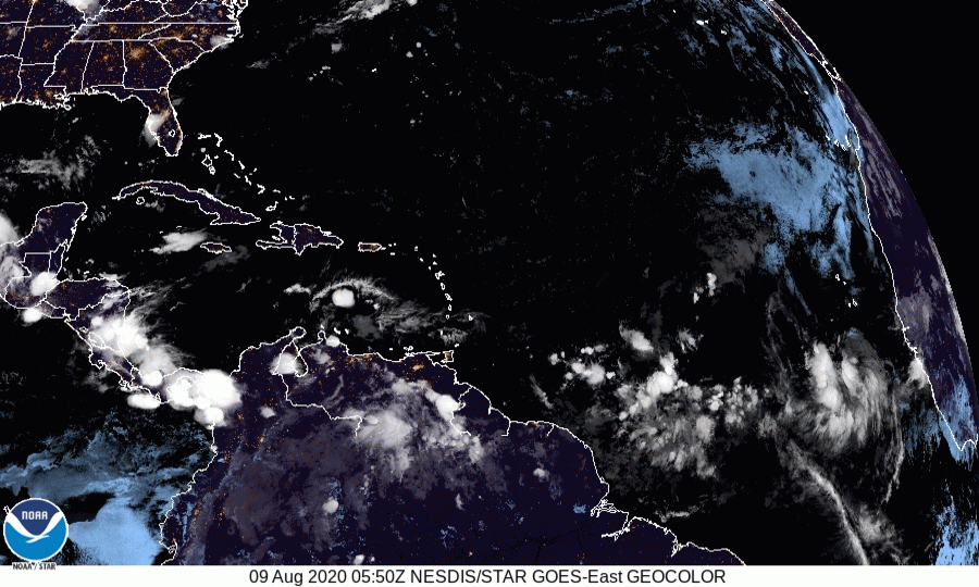
Tropical Weather Outlook
NWS National Hurricane Center Miami FL
800 AM EDT Sun Aug 9 2020

For the North Atlantic...Caribbean Sea and the Gulf of Mexico:

1. Showers and thunderstorms associated with a tropical wave located a
few hundred miles south-southwest of the Cabo Verde Islands are
showing some signs of organization. Environmental conditions
could support some development of this system over the next
couple of days while it moves westward at 15 mph across the
tropical eastern Atlantic.
* Formation chance through 48 hours...low...20 percent.
* Formation chance through 5 days...low...20 percent.

Forecaster Berg


Thread that was the topic for this wave at Talking Tropics forum.

viewtopic.php?f=31&t=121114
5 likes   
Visit the Caribbean-Central America Weather Thread where you can find at first post web cams,radars
and observations from Caribbean basin members Click Here

OuterBanker
S2K Supporter
S2K Supporter
Posts: 1704
Joined: Wed Feb 26, 2003 10:53 am
Location: Nags Head, NC
Contact:

Re: ATL: INVEST 95L - Discussion

#2 Postby OuterBanker » Sun Aug 09, 2020 7:35 am

20% is too generous I think. Next Sunday maybe. Let's enjoy the lull this week. The real season begins next week. It will be a hum dinger I'm afraid.
1 likes   

User avatar
abajan
S2K Supporter
S2K Supporter
Posts: 4175
Joined: Sun Sep 07, 2003 5:10 am
Location: Barbados

Re: ATL: INVEST 95L - Discussion

#3 Postby abajan » Sun Aug 09, 2020 8:07 am

OuterBanker wrote:20% is too generous I think. Next Sunday maybe. Let's enjoy the lull this week. The real season begins next week. It will be a hum dinger I'm afraid.

The thing is, as Mark Sudduth points out in his latest video, the longer they take to develop while in the eastern MDR, the more of a threat they become to the Antilles, Central America, North America etc. Should 95L encounter more favorable conditions farther west, it could become problematic.
6 likes   

jlauderdal
S2K Supporter
S2K Supporter
Posts: 6772
Joined: Wed May 19, 2004 5:46 am
Location: NE Fort Lauderdale
Contact:

Re: RE: Re: ATL: INVEST 95L - Discussion

#4 Postby jlauderdal » Sun Aug 09, 2020 8:18 am

abajan wrote:
OuterBanker wrote:20% is too generous I think. Next Sunday maybe. Let's enjoy the lull this week. The real season begins next week. It will be a hum dinger I'm afraid.

The thing is, as Mark Sudduth points out in his latest video, the longer they take to develop while in the eastern MDR, the more of a threat they become to the Antilles, Central America, North America etc. Should 95L encounter more favorable conditions farther west, it could become problematic.
Development w of 60 is high danger
3 likes   

User avatar
toad strangler
S2K Supporter
S2K Supporter
Posts: 4162
Joined: Sun Jul 28, 2013 3:09 pm
Location: Earth
Contact:

Re: ATL: INVEST 95L - Discussion

#5 Postby toad strangler » Sun Aug 09, 2020 8:27 am

abajan wrote:
OuterBanker wrote:20% is too generous I think. Next Sunday maybe. Let's enjoy the lull this week. The real season begins next week. It will be a hum dinger I'm afraid.

The thing is, as Mark Sudduth points out in his latest video, the longer they take to develop while in the eastern MDR, the more of a threat they become to the Antilles, Central America, North America etc. Should 95L encounter more favorable conditions farther west, it could become problematic.


Great video by Sudduth. Any of these waves with no modeled future could be time bombs the further west they go.
4 likes   

User avatar
Kazmit
Category 5
Category 5
Posts: 1915
Age: 21
Joined: Mon Jul 25, 2016 8:49 am
Location: Williamsburg VA for college, Bermuda otherwise

Re: ATL: INVEST 95L - Discussion

#6 Postby Kazmit » Sun Aug 09, 2020 8:30 am

Is it just me or has the NHC been more lenient with designating invests? In my experience I've usually only seen invests when the disturbance is 40% or higher.
0 likes   
Igor 2010, Sandy 2012, Fay 2014, Gonzalo 2014, Joaquin 2015, Nicole 2016, Humberto 2019

I am only a tropical weather enthusiast. My predictions are not official and may or may not be backed by sound meteorological data. For official information, please refer to the NHC and NWS products.

User avatar
cycloneye
Admin
Admin
Posts: 139131
Age: 67
Joined: Thu Oct 10, 2002 10:54 am
Location: San Juan, Puerto Rico

Re: ATL: INVEST 95L - Discussion

#7 Postby cycloneye » Sun Aug 09, 2020 8:31 am

Looking good.

Image
9 likes   
Visit the Caribbean-Central America Weather Thread where you can find at first post web cams,radars
and observations from Caribbean basin members Click Here

User avatar
SFLcane
S2K Supporter
S2K Supporter
Posts: 9609
Age: 46
Joined: Sat Jun 05, 2010 1:44 pm
Location: Lake Worth Florida

Re: RE: Re: ATL: INVEST 95L - Discussion

#8 Postby SFLcane » Sun Aug 09, 2020 9:13 am

jlauderdal wrote:
abajan wrote:
OuterBanker wrote:20% is too generous I think. Next Sunday maybe. Let's enjoy the lull this week. The real season begins next week. It will be a hum dinger I'm afraid.

The thing is, as Mark Sudduth points out in his latest video, the longer they take to develop while in the eastern MDR, the more of a threat they become to the Antilles, Central America, North America etc. Should 95L encounter more favorable conditions farther west, it could become problematic.
Development w of 60 is high danger


Not when you have a huge TUTT awaiting for now.
1 likes   

supercane4867
Category 5
Category 5
Posts: 4966
Joined: Wed Nov 14, 2012 10:43 am

Re: ATL: INVEST 95L - Discussion

#9 Postby supercane4867 » Sun Aug 09, 2020 9:13 am

Kazmit wrote:Is it just me or has the NHC been more lenient with designating invests? In my experience I've usually only seen invests when the disturbance is 40% or higher.

I’ve seen they designate an invest before even mentioning in TWO.
0 likes   

User avatar
GCANE
S2K Supporter
S2K Supporter
Posts: 10787
Joined: Mon Oct 22, 2007 8:03 am

Re: ATL: INVEST 95L - Discussion

#10 Postby GCANE » Sun Aug 09, 2020 9:22 am

IR Satellites looks close to be a TD.
Well developed 700mb vort.
Wave ahead appears to have swept SAL somewhat.

Image

Image
0 likes   

User avatar
toad strangler
S2K Supporter
S2K Supporter
Posts: 4162
Joined: Sun Jul 28, 2013 3:09 pm
Location: Earth
Contact:

Re: ATL: INVEST 95L - Discussion

#11 Postby toad strangler » Sun Aug 09, 2020 9:24 am

Soooooo ... when do we enter that lull? :spam:

 http://twitter.com/cyclonicwx/status/1292462702032453634


6 likes   

User avatar
TheStormExpert
Category 5
Category 5
Posts: 8487
Age: 30
Joined: Wed Feb 16, 2011 5:38 pm
Location: Palm Beach Gardens, FL

Re: ATL: INVEST 95L - Discussion

#12 Postby TheStormExpert » Sun Aug 09, 2020 9:26 am

Kazmit wrote:Is it just me or has the NHC been more lenient with designating invests? In my experience I've usually only seen invests when the disturbance is 40% or higher.

No they sometimes even designate Invests with only 10% in the two and five day.
0 likes   
The following post is NOT an official forecast and should not be used as such. It is just the opinion of the poster and may or may not be backed by sound meteorological data. It is NOT endorsed by storm2k.org.

User avatar
TheStormExpert
Category 5
Category 5
Posts: 8487
Age: 30
Joined: Wed Feb 16, 2011 5:38 pm
Location: Palm Beach Gardens, FL

Re: ATL: INVEST 95L - Discussion

#13 Postby TheStormExpert » Sun Aug 09, 2020 9:43 am

GCANE wrote:IR Satellites and if you want to extrapolate ASCAT, looks close to be a TD.
Well developed 700mb vort.
Wave ahead appears to have swept SAL somewhat.


https://i.imgur.com/QOxQLRO.gif

https://i.imgur.com/fCLYfeh.gif

https://i.imgur.com/PmlodnU.gif

https://i.imgur.com/3KNUw5E.jpg

https://i.imgur.com/oJER3zT.gif

Those first three images look to be from an area just off the New England coast not Invest 95L. :lol:
0 likes   
The following post is NOT an official forecast and should not be used as such. It is just the opinion of the poster and may or may not be backed by sound meteorological data. It is NOT endorsed by storm2k.org.

User avatar
SFLcane
S2K Supporter
S2K Supporter
Posts: 9609
Age: 46
Joined: Sat Jun 05, 2010 1:44 pm
Location: Lake Worth Florida

Re: ATL: INVEST 95L - Discussion

#14 Postby SFLcane » Sun Aug 09, 2020 9:54 am

toad strangler wrote:Soooooo ... when do we enter that lull? :spam:

http://twitter.com/cyclonicwx/status/1292462702032453634?s=20


Lull is there.. we should remain relatively quite through mid aug other then a short lived tc as this one. Conditions ahead for this wave a quite hostile it most likely will not last long. The problem the next two weeks will be enhanced trade winds and upper-level shear because the MJO is in the Pacific.
1 likes   

User avatar
toad strangler
S2K Supporter
S2K Supporter
Posts: 4162
Joined: Sun Jul 28, 2013 3:09 pm
Location: Earth
Contact:

Re: ATL: INVEST 95L - Discussion

#15 Postby toad strangler » Sun Aug 09, 2020 9:57 am

SFLcane wrote:
toad strangler wrote:Soooooo ... when do we enter that lull? :spam:

http://twitter.com/cyclonicwx/status/1292462702032453634?s=20


Lull is there.. we should remain relatively quite through mid aug other then a short lived tc as this one. Conditions ahead for this wave a quite hostile it most likely will not last long. The problem the next two weeks will be enhanced trade winds and upper-level shear because the MJO is in the Pacific.


sure, which will allow energy such as 95L to just float on W ... to the far W. That alone can take 10 plus days. I'm just sayin, things aren't as quite as detrimental as they seem. We'll see.
2 likes   

User avatar
gatorcane
S2K Supporter
S2K Supporter
Posts: 23499
Age: 46
Joined: Sun Mar 13, 2005 3:54 pm
Location: Boca Raton, FL

Re: ATL: INVEST 95L - Discussion

#16 Postby gatorcane » Sun Aug 09, 2020 10:01 am

Coming into view on the far right:

Image
5 likes   

jlauderdal
S2K Supporter
S2K Supporter
Posts: 6772
Joined: Wed May 19, 2004 5:46 am
Location: NE Fort Lauderdale
Contact:

Re: RE: Re: ATL: INVEST 95L - Discussion

#17 Postby jlauderdal » Sun Aug 09, 2020 10:24 am

SFLcane wrote:
jlauderdal wrote:
abajan wrote:The thing is, as Mark Sudduth points out in his latest video, the longer they take to develop while in the eastern MDR, the more of a threat they become to the Antilles, Central America, North America etc. Should 95L encounter more favorable conditions farther west, it could become problematic.
Development w of 60 is high danger


Not when you have a huge TUTT awaiting for now.


I should have clarified, w of 60 is generally high danger
2 likes   

User avatar
gatorcane
S2K Supporter
S2K Supporter
Posts: 23499
Age: 46
Joined: Sun Mar 13, 2005 3:54 pm
Location: Boca Raton, FL

Re: ATL: INVEST 95L - Discussion

#18 Postby gatorcane » Sun Aug 09, 2020 10:33 am

Dry Saharan air looks to be the main issue this wave will face over the next several days. If it manages to detach from the ITCZ, it’s moisture source could get cut off. But I agree that we are entering that time of year we need to watch what happens with this wave downstream when it gets into the Western Atlantic west of 60W as some have mentioned. For now the models show a high shear zone over the Lesser Antilles but that is out near a week from now so let’s see if that shear verifies. If the EPAC stays active it might.
4 likes   

User avatar
ScottNAtlanta
Category 5
Category 5
Posts: 1999
Joined: Sat May 25, 2013 3:11 pm
Location: Atlanta, GA

Re: ATL: INVEST 95L - Discussion

#19 Postby ScottNAtlanta » Sun Aug 09, 2020 10:44 am

The MJO might be in the Pacific, but it wont be there long

Image
0 likes   
The posts in this forum are NOT official forecast and should not be used as such. They are just the opinion of the poster and may or may not be backed by sound meteorological data. They are NOT endorsed by any professional institution or storm2k.org. For official information, please refer to the NHC and NWS products.

User avatar
chaser1
S2K Supporter
S2K Supporter
Posts: 4683
Age: 63
Joined: Sat Oct 15, 2005 5:59 pm
Location: Longwood, Fl

Re: ATL: INVEST 95L - Discussion

#20 Postby chaser1 » Sun Aug 09, 2020 10:47 am

Tag-along-friend lol (see the main COC, but then look closely at her little friend to the SW )
https://i.imgur.com/ldalBgp.gifv
3 likes   
Personal Forecast Disclaimer:
The posts in this forum are NOT official forecast and should not be used as such. They are just the opinion of the poster and may or may not be backed by sound meteorological data. They are NOT endorsed by any professional institution or storm2k.org. For official information, please refer to the NHC and NWS products.


Return to “2020”

Who is online

Users browsing this forum: No registered users and 32 guests