ATL: GAMMA - Models
Moderator: S2k Moderators


-
jlauderdal
- S2K Supporter

- Posts: 6771
- Joined: Wed May 19, 2004 5:46 am
- Location: NE Fort Lauderdale
- Contact:
Re: ATL: Invest 91L-Models
Model runs only until it turns into debate, discussion and conjecture.Ivanhater wrote:Model runs only
8 likes

Re: ATL: Invest 91L - Models
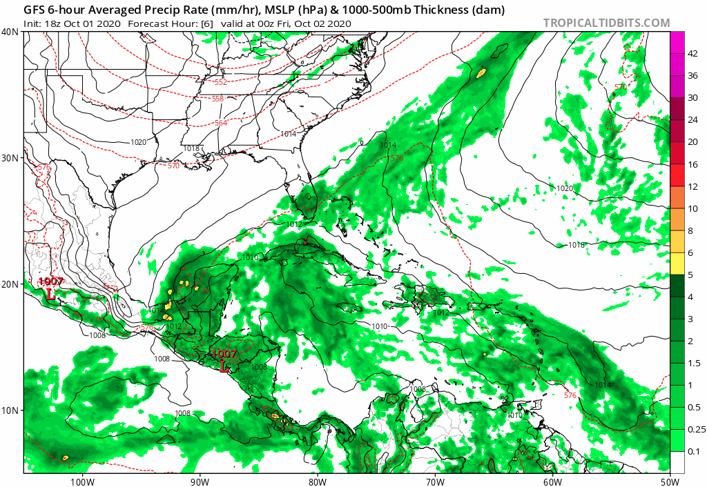
UKMet finally shows this developing, with a TS in the Bay of Campeche.

0 likes
Kendall -> SLO -> PBC
Memorable Storms: Katrina (for its Florida landfall...) Wilma Matthew Irma
Memorable Storms: Katrina (for its Florida landfall...) Wilma Matthew Irma
-
Hypercane_Kyle

- Category 5

- Posts: 2900
- Joined: Sat Mar 07, 2015 7:58 pm
- Location: Cape Canaveral, FL
Re: ATL: Invest 91L - Models
18z GFS coming in significantly stronger with a potent hurricane in the BOC.
2 likes
My posts are my own personal opinion, defer to the National Hurricane Center (NHC) and other NOAA products for decision making during hurricane season.
-
Hypercane_Kyle
- Category 5
- Posts: 2900
- Joined: Sat Mar 07, 2015 7:58 pm
- Location: Cape Canaveral, FL
Re: ATL: Invest 91L - Models
Major hurricane in the BoC on this run. Lingers for days nearing Tampico by D10.
0 likes
My posts are my own personal opinion, defer to the National Hurricane Center (NHC) and other NOAA products for decision making during hurricane season.

Re: ATL: Invest 91L - Models
18z GFS: Landfall near Playa de Tuxpan as a TS/Cat1 at hour 240
0 likes
Re: ATL: Invest 91L - Models
Could be an Opal if it sits in the BOC waiting for a front to dig down and pull it NE. This time of year storms very rarely move westward in the Gulf.
0 likes
-
Hypercane_Kyle
- Category 5
- Posts: 2900
- Joined: Sat Mar 07, 2015 7:58 pm
- Location: Cape Canaveral, FL
Re: ATL: Invest 91L - Models
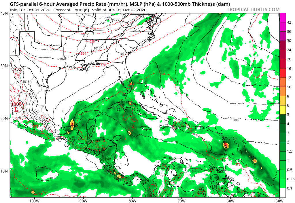
18z GFS-Para has a landfall in Texas as a hurricane.
0 likes
My posts are my own personal opinion, defer to the National Hurricane Center (NHC) and other NOAA products for decision making during hurricane season.
-
AutoPenalti
- Category 5
- Posts: 3949
- Age: 27
- Joined: Mon Aug 17, 2015 4:16 pm
- Location: Ft. Lauderdale, Florida
Re: ATL: Invest 91L - Models
Florida deflector shield is in full effect on parallel.
Looks like Texas is in play now.
0 likes
The posts in this forum are NOT official forecasts and should not be used as such. They are just the opinion of the poster and may or may not be backed by sound meteorological data. They are NOT endorsed by any professional institution or STORM2K. For official information, please refer to products from the NHC and NWS.
Model Runs Cheat Sheet:
GFS (5:30 AM/PM, 11:30 AM/PM)
HWRF, GFDL, UKMET, NAVGEM (6:30-8:00 AM/PM, 12:30-2:00 AM/PM)
ECMWF (1:45 AM/PM)
TCVN is a weighted averaged

Re: ATL: Invest 91L - Models
0Z UKMET
NEW TROPICAL CYCLONE FORECAST TO DEVELOP AFTER 24 HOURS
FORECAST POSITION AT T+ 24 : 18.6N 86.7W
LEAD CENTRAL MAXIMUM WIND
VERIFYING TIME TIME POSITION PRESSURE (MB) SPEED (KNOTS)
-------------- ---- -------- ------------- -------------
0000UTC 03.10.2020 24 18.6N 86.7W 1004 30
1200UTC 03.10.2020 36 19.3N 87.4W 1003 30
0000UTC 04.10.2020 48 19.8N 88.2W 1004 30
1200UTC 04.10.2020 60 CEASED TRACKING
0 likes
Personal Forecast Disclaimer:
The posts in this forum are NOT official forecasts and should not be used as such. They are just the opinion of the poster and may or may not be backed by sound meteorological data. They are NOT endorsed by any professional institution or storm2k.org. For official information, please refer to the NHC and NWS products.
The posts in this forum are NOT official forecasts and should not be used as such. They are just the opinion of the poster and may or may not be backed by sound meteorological data. They are NOT endorsed by any professional institution or storm2k.org. For official information, please refer to the NHC and NWS products.
-
Astromanía
- Category 2

- Posts: 737
- Age: 25
- Joined: Sat Aug 25, 2018 10:34 pm
- Location: Monterrey, N.L, México
Re: ATL: Invest 91L - Models
Mmmm I could be in the path of this thing, I should watch this closely
0 likes
Re: ATL: Invest 91L - Models
00z EURO buries 91L in the BOC after crossing Yucatan, showing very little development.

1 likes

Re: ATL: Invest 91L - Models
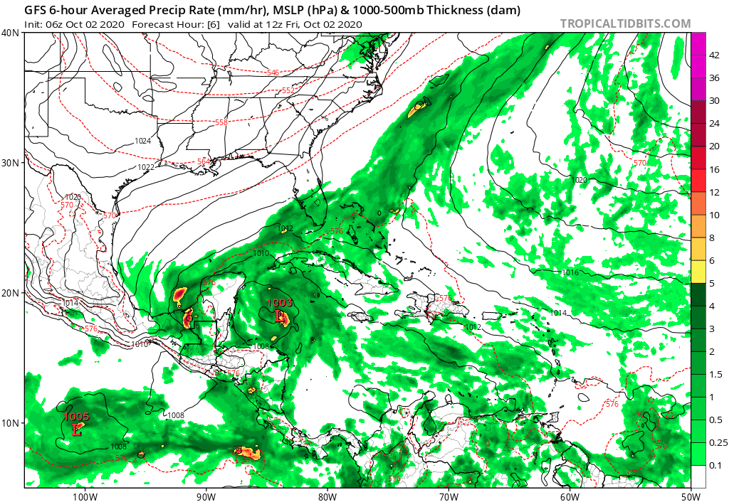
GFS run-to-run trending to a much strong TC and a breaking down of the ridge to the north.
If trend continues, a lot of Texas folks could be getting pretty nervous.
If trend continues, a lot of Texas folks could be getting pretty nervous.
2 likes
Re: ATL: Invest 91L - Models
GCANE wrote:GFS run-to-run trending to a much strong TC and a breaking down of the ridge to the north.
If trend continues, a lot of Texas folks could be getting pretty nervous.
https://imgur.com/YdUjgl0
Not sure I see this getting in Texas.
It’s October. Storms this time of year don’t go west, they go NE. But it’s 2020. Everything is a$$ backwards.
0 likes
-
TheStormExpert

- Category 5
- Posts: 8487
- Age: 30
- Joined: Wed Feb 16, 2011 5:38 pm
- Location: Palm Beach Gardens, FL
Re: ATL: Invest 91L - Models
AutoPenalti wrote:
Florida deflector shield is in full effect on parallel.
Looks like Texas is in play now.
Texas rarely ever sees anything in October thanks to cold fronts moving into the Western Gulf.
0 likes
The following post is NOT an official forecast and should not be used as such. It is just the opinion of the poster and may or may not be backed by sound meteorological data. It is NOT endorsed by storm2k.org.

Re: ATL: Invest 91L - Models
The GFS and GFS-Para have been consistent with the left-turn scenario, and I believe them over the CMC’s broad gyre scenario because 91L appears to be much further developed than the CMC has it. The ICON is also showing that left-turn BoC scenario.
0 likes
Irene '11 Sandy '12 Hermine '16 5/15/2018 Derecho Fay '20 Isaias '20 Elsa '21 Henri '21 Ida '21
I am only a meteorology enthusiast who knows a decent amount about tropical cyclones. Look to the professional mets, the NHC, or your local weather office for the best information.
I am only a meteorology enthusiast who knows a decent amount about tropical cyclones. Look to the professional mets, the NHC, or your local weather office for the best information.

Re: ATL: Invest 91L - Models
AutoPenalti wrote:
Florida deflector shield is in full effect on parallel.
Looks like Texas is in play now.
06Z GFS steer horns weak storm right towards Florida with trough shearing then trough misses.
High pressure rebuilds allowing BOC major hurricane to develop.
Steer horns left into Texas before the October savior trough?
TST or FDS moo.
0 likes
Who is online
Users browsing this forum: No registered users and 20 guests