EPAC: NORBERT - Post-Tropical

Moderator: S2k Moderators

Message
Author
User avatar
cycloneye
Admin
Admin
Posts: 139096
Age: 67
Joined: Thu Oct 10, 2002 10:54 am
Location: San Juan, Puerto Rico

Re: EPAC: NORBERT - Remnants

#21 Postby cycloneye » Sat Oct 10, 2020 2:14 pm

Disorganized showers and thunderstorms located several hundred miles
south-southwest of Manzanillo, Mexico are associated with the
remnants of Norbert. Little to no development of this disturbance is
expected over the next couple of days due to unfavorable
environmental conditions. However, by the middle of next week the
disturbance is expected to begin moving west-northwestward at 10 to
15 mph into an area where conditions are expected to become more
favorable for some development.
* Formation chance through 48 hours...low...near 0 percent.
* Formation chance through 5 days...low...20 percent.
0 likes   
Visit the Caribbean-Central America Weather Thread where you can find at first post web cams,radars
and observations from Caribbean basin members Click Here

User avatar
cycloneye
Admin
Admin
Posts: 139096
Age: 67
Joined: Thu Oct 10, 2002 10:54 am
Location: San Juan, Puerto Rico

Re: EPAC: NORBERT - Remnants

#22 Postby cycloneye » Sat Oct 10, 2020 7:12 pm

Disorganized showers and thunderstorms located several hundred
miles southwest of the coast of southwestern Mexico are associated
with the remnants of Norbert. This system is forecast to move very
little during the next couple of days, and little to no development
is expected during that time. Some development appears possible by
the middle of next week when the system begins to move toward the
northwest at 10 to 15 mph.
* Formation chance through 48 hours...low...near 0 percent.
* Formation chance through 5 days...low...30 percent.
0 likes   
Visit the Caribbean-Central America Weather Thread where you can find at first post web cams,radars
and observations from Caribbean basin members Click Here

User avatar
cycloneye
Admin
Admin
Posts: 139096
Age: 67
Joined: Thu Oct 10, 2002 10:54 am
Location: San Juan, Puerto Rico

Re: EPAC: NORBERT - Remnants

#23 Postby cycloneye » Sun Oct 11, 2020 3:27 pm

Tropical Weather Outlook
NWS National Hurricane Center Miami FL
1100 AM PDT Sun Oct 11 2020

For the eastern North Pacific...east of 140 degrees west longitude:

1. Showers and thunderstorms, partially associated with the remnants
of Norbert, are showing signs of organization a few hundred miles
southwest of the coast of southwestern Mexico. Upper-level winds
are forecast to become more conducive for development, and a
tropical depression could form during the next few days while the
system moves slowly to the west-northwest or northwest.
* Formation chance through 48 hours...low...30 percent.
* Formation chance through 5 days...medium...50 percent.

Forecaster Blake
0 likes   
Visit the Caribbean-Central America Weather Thread where you can find at first post web cams,radars
and observations from Caribbean basin members Click Here

User avatar
cycloneye
Admin
Admin
Posts: 139096
Age: 67
Joined: Thu Oct 10, 2002 10:54 am
Location: San Juan, Puerto Rico

Re: EPAC: NORBERT - Remnants

#24 Postby cycloneye » Sun Oct 11, 2020 6:59 pm

Tropical Weather Outlook
NWS National Hurricane Center Miami FL
500 PM PDT Sun Oct 11 2020

For the eastern North Pacific...east of 140 degrees west longitude:

1. Showers and thunderstorms, partially associated with the remnants
of Norbert, have increased in organization a few hundred miles
southwest of the coast of southwestern Mexico. Upper-level winds are
gradually becoming more conducive for development, and a tropical
depression or a tropical storm could form later tonight or on
Monday while the system moves slowly toward the west-northwest or
northwest.
* Formation chance through 48 hours...medium...60 percent.
* Formation chance through 5 days...high...70 percent.

Forecaster Stewart
0 likes   
Visit the Caribbean-Central America Weather Thread where you can find at first post web cams,radars
and observations from Caribbean basin members Click Here

User avatar
ElectricStorm
Category 5
Category 5
Posts: 4562
Age: 23
Joined: Tue Aug 13, 2019 11:23 pm
Location: Skiatook, OK / Norman, OK

Re: EPAC: NORBERT - Remnants

#25 Postby ElectricStorm » Sun Oct 11, 2020 7:14 pm

cycloneye wrote:
Tropical Weather Outlook
NWS National Hurricane Center Miami FL
500 PM PDT Sun Oct 11 2020

For the eastern North Pacific...east of 140 degrees west longitude:

1. Showers and thunderstorms, partially associated with the remnants
of Norbert, have increased in organization a few hundred miles
southwest of the coast of southwestern Mexico. Upper-level winds are
gradually becoming more conducive for development, and a tropical
depression or a tropical storm could form later tonight or on
Monday while the system moves slowly toward the west-northwest or
northwest.
* Formation chance through 48 hours...medium...60 percent.
* Formation chance through 5 days...high...70 percent.

Forecaster Stewart

Looks like Norbert isn't quite done yet.
1 likes   
I am in no way a professional. Take what I say with a grain of salt as I could be totally wrong. Please refer to the NHC, NWS, or SPC for official information.

Boomer Sooner!

User avatar
cycloneye
Admin
Admin
Posts: 139096
Age: 67
Joined: Thu Oct 10, 2002 10:54 am
Location: San Juan, Puerto Rico

Re: EPAC: NORBERT - Remnants

#26 Postby cycloneye » Mon Oct 12, 2020 8:57 am

Tropical Weather Outlook
NWS National Hurricane Center Miami FL
500 AM PDT Mon Oct 12 2020

For the eastern North Pacific...east of 140 degrees west longitude:

1. An area of low pressure associated in part with the remnants of
Norbert is located a few hundred miles southwest of the southwestern
coast of Mexico. Although showers and thunderstorms continue to show
signs of organization, the surface circulation remains poorly
defined. However, environmental conditions are expected to
become more favorable for development during the next day or so,
and a tropical depression is likely to form within a few days while
the system moves slowly toward the west-northwest or northwest.
* Formation chance through 48 hours...medium...60 percent.
* Formation chance through 5 days...high...70 percent.

Forecaster Cangialosi
0 likes   
Visit the Caribbean-Central America Weather Thread where you can find at first post web cams,radars
and observations from Caribbean basin members Click Here

User avatar
cycloneye
Admin
Admin
Posts: 139096
Age: 67
Joined: Thu Oct 10, 2002 10:54 am
Location: San Juan, Puerto Rico

Re: EPAC: NORBERT - Remnants

#27 Postby cycloneye » Mon Oct 12, 2020 2:11 pm

Tropical Weather Outlook
NWS National Hurricane Center Miami FL
1100 AM PDT Mon Oct 12 2020

For the eastern North Pacific...east of 140 degrees west longitude:

1. An area of low pressure associated in part with the remnants of
Norbert is located a few hundred miles southwest of the southwestern
coast of Mexico. Satellite images suggest that the low is a little
better defined than it was yesterday, but the associated showers
and thunderstorms have become less organized during the past
several hours. This system could still become a short-lived
tropical depression while it moves west-northwestward during the
next day or so before environmental conditions become less favorable
for development.
* Formation chance through 48 hours...medium...60 percent.
* Formation chance through 5 days...medium...60 percent.

Forecaster Cangialosi
0 likes   
Visit the Caribbean-Central America Weather Thread where you can find at first post web cams,radars
and observations from Caribbean basin members Click Here
User avatar
Kingarabian
S2K Supporter
S2K Supporter
Posts: 15435
Joined: Sat Aug 08, 2009 3:06 am
Location: Honolulu, Hawaii

Re: EPAC: NORBERT - Remnants

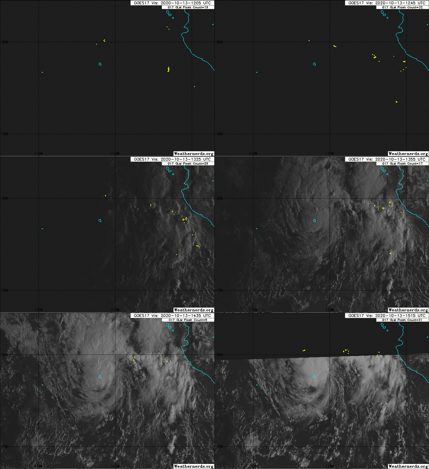
#28 Postby Kingarabian » Tue Oct 13, 2020 3:23 am

Norbert is back from the dead. I've seen worse Atlantic systems classified.

Image
0 likes   
RIP Kobe Bryant

User avatar
cycloneye
Admin
Admin
Posts: 139096
Age: 67
Joined: Thu Oct 10, 2002 10:54 am
Location: San Juan, Puerto Rico

Re: EPAC: NORBERT - Remnants

#29 Postby cycloneye » Tue Oct 13, 2020 8:44 am

Tropical Weather Outlook
NWS National Hurricane Center Miami FL
500 AM PDT Tue Oct 13 2020

For the eastern North Pacific...east of 140 degrees west longitude:

1. An area of low pressure, associated in part with the remnants of
Norbert, is located just southeast of Socorro Island, Mexico.
Satellite imagery indicates the low continues to produce showers
and thunderstorms near its center, and overnight satellite-derived
wind data revealed the low was becoming better organized. If this
development trend continues, a short-lived tropical depression could
form today or tonight while the low moves slowly west-northwestward.
However, environmental conditions are forecast to become less
conducive for development by Wednesday.
* Formation chance through 48 hours...high...70 percent.
* Formation chance through 5 days...high...70 percent.

Forecaster Reinhart/Cangialosi
0 likes   
Visit the Caribbean-Central America Weather Thread where you can find at first post web cams,radars
and observations from Caribbean basin members Click Here

Sciencerocks
Category 5
Category 5
Posts: 7286
Age: 38
Joined: Thu Jul 06, 2017 1:51 am

Re: EPAC: NORBERT - Remnants

#30 Postby Sciencerocks » Tue Oct 13, 2020 10:31 am

Image
0 likes   

User avatar
cycloneye
Admin
Admin
Posts: 139096
Age: 67
Joined: Thu Oct 10, 2002 10:54 am
Location: San Juan, Puerto Rico

Re: EPAC: NORBERT - Remnants

#31 Postby cycloneye » Tue Oct 13, 2020 12:48 pm

Tropical Weather Outlook
NWS National Hurricane Center Miami FL
1100 AM PDT Tue Oct 13 2020

For the eastern North Pacific...east of 140 degrees west longitude:

1. Recent visible satellite imagery, satellite-derived wind data, and
surface observations suggest that an area of low pressure centered
just northwest of Socorro Island, Mexico is becoming better
organized. If current development trends continue, advisories may be
started on a short-lived tropical depression later today. The system
is forecast to move northwestward at 10 to 15 mph through Wednesday,
when it is expected to encounter cooler waters and stronger
upper-level winds that will likely inhibit further development.
* Formation chance through 48 hours...high...90 percent.
* Formation chance through 5 days...high...90 percent.

Forecaster Reinhart/Beven
0 likes   
Visit the Caribbean-Central America Weather Thread where you can find at first post web cams,radars
and observations from Caribbean basin members Click Here

User avatar
cycloneye
Admin
Admin
Posts: 139096
Age: 67
Joined: Thu Oct 10, 2002 10:54 am
Location: San Juan, Puerto Rico

Re: EPAC: NORBERT - Tropical Depression

#32 Postby cycloneye » Tue Oct 13, 2020 3:42 pm

Tropical Depression Norbert Discussion Number 20
NWS National Hurricane Center Miami FL EP192020
300 PM MDT Tue Oct 13 2020

Low pressure associated with the remnants of Norbert has become
well-organized today, with persistent convection near and north of
the estimated low-level center. Partial ScatSat and ASCAT-B passes
near of this system suggest the low-level circulation is closed,
and 25-30 kt scatterometer winds are noted in the northeast
quadrant of the low. Additionally, earlier surface observations from
Socorro Island, Mexico and ship observations from the Nathaniel B
Palmer research vessel reported northwesterly winds on the backside
of the system. Together, all this information supports the
conclusion that the remnants of Norbert have redeveloped into a
tropical depression. The initial intensity for Norbert is set at 30
kt based on the recent ASCAT-B overpass and a T2.0 subjective
Dvorak classification from SAB.

Norbert is only forecast to be a short-lived depression given the
increasingly hostile environmental conditions it is expected to face
during the next 24-48 h. While the vertical wind shear is currently
weak, it is forecast to quickly increase by Wednesday courtesy of a
mid- to upper-level low pressure system centered offshore of the
Baja California peninsula. The majority of the guidance shows little
or no intensity change, and the official NHC intensity forecast
calls for Norbert to remain a 30-kt depression during the next 24 h.
This should be followed by weakening as Norbert transitions to a
remnant low by 48 h due to 20+ kt of deep-layer shear and decreased
oceanic heat content. The remnant low is expected to dissipate by
Thursday night.

Norbert is currently moving to the northwest at 11 kt. This general
motion will continue for the next 24 h as the depression moves
between a deep-layer ridge centered over northern Mexico and the
upper low offshore of Baja California. As the upper low shifts
westward, Norbert's forward speed will slow as the depression is
drawn more northward before dissipation.

FORECAST POSITIONS AND MAX WINDS

INIT 13/2100Z 19.8N 111.7W 30 KT 35 MPH
12H 14/0600Z 21.1N 112.8W 30 KT 35 MPH
24H 14/1800Z 23.0N 114.3W 30 KT 35 MPH
36H 15/0600Z 24.4N 115.3W 25 KT 30 MPH
48H 15/1800Z 25.5N 115.3W 25 KT 30 MPH...POST-TROP/REMNT LOW
60H 16/0600Z...DISSIPATED

$$
Forecaster Reinhart/Cangialosi
0 likes   
Visit the Caribbean-Central America Weather Thread where you can find at first post web cams,radars
and observations from Caribbean basin members Click Here

User avatar
cycloneye
Admin
Admin
Posts: 139096
Age: 67
Joined: Thu Oct 10, 2002 10:54 am
Location: San Juan, Puerto Rico

Re: EPAC: NORBERT - Tropical Storm

#33 Postby cycloneye » Tue Oct 13, 2020 9:37 pm

Tropical Storm Norbert Discussion Number 21
NWS National Hurricane Center Miami FL EP192020
900 PM MDT Tue Oct 13 2020

Norbert has increased in organization this evening, with a pair of
microwave passes as well as infrared satellite imagery showing a
tightly curved band of convection wrapping about halfway around the
low-level center. In addition, a well-defined outflow pattern is
surrounding the cyclone in the current low-shear environment. Based
on these developmental trends, the initial intensity has been
increased to 35 kt, which is in agreement with the latest Dvorak
intensity estimate from TAFB.

There is only about a 12-18 h opportunity for Norbert to maintain
its current strength or perhaps intensify a little more before it
reaches a hostile environment just to its north. By 24 h, the
cyclone is forecast to encounter strong southwesterly shear and a
dry and stable atmospheric environment, while moving over cooler
waters. Therefore, the cyclone should start weakening by 24 h and
should degenerate into a remnant low devoid of deep convection by
48 h. The model guidance indicates the remnant low should dissipate
very soon thereafter. The latest NHC intensity forecast is close to
the latest consensus intensity guidance, and is only higher than the
previous NHC forecast due to the increase in the initial intensity.

Norbert has been moving northwestward at around 13 kt since this
afternoon as the cyclone has been steered between a deep-layer ridge
centered over northern Mexico and an upper-level low offshore of
Baja California. As the upper low shifts westward over the next day
or so, Norbert's forward speed should decrease. What remains of
Norbert should then turn northward on Thursday within the low-level
flow.


FORECAST POSITIONS AND MAX WINDS

INIT 14/0300Z 21.0N 112.7W 35 KT 40 MPH
12H 14/1200Z 22.4N 113.8W 35 KT 40 MPH
24H 15/0000Z 24.2N 115.0W 30 KT 35 MPH
36H 15/1200Z 25.5N 115.6W 25 KT 30 MPH
48H 16/0000Z 26.5N 115.5W 25 KT 30 MPH...POST-TROP/REMNT LOW
60H 16/1200Z...DISSIPATED

$$
Forecaster Latto
0 likes   
Visit the Caribbean-Central America Weather Thread where you can find at first post web cams,radars
and observations from Caribbean basin members Click Here

User avatar
wxman57
Moderator-Pro Met
Moderator-Pro Met
Posts: 22482
Age: 66
Joined: Sat Jun 21, 2003 8:06 pm
Location: Houston, TX (southwest)

Re: EPAC: NORBERT - Tropical Storm

#34 Postby wxman57 » Wed Oct 14, 2020 8:22 am

2020, the year of the zombie storms...
1 likes   

User avatar
cycloneye
Admin
Admin
Posts: 139096
Age: 67
Joined: Thu Oct 10, 2002 10:54 am
Location: San Juan, Puerto Rico

Re: EPAC: NORBERT - Tropical Storm

#35 Postby cycloneye » Wed Oct 14, 2020 9:00 am

Tropical Storm Norbert Discussion Number 22
NWS National Hurricane Center Miami FL EP192020
300 AM MDT Wed Oct 14 2020

Norbert continues to produce a concentrated area of deep convection,
but it has been very difficult pinpointing the exact location of the
center overnight. Earlier ASCAT data and an 0152 UTC SSMIS
microwave overpass suggests that the center could be a little north
of the previous estimates, but overnight shortwave infrared imagery
and TAFB and SAB fixes still place it closer to the southern portion
of the convective mass. The advisory position is a compromise
between the various estimates, but leans toward the previous track
out of respect for continuity. Dvorak estimates from TAFB and SAB
support an intensity of 35 kt, which is used as the initial wind
speed for this advisory. The earlier ASCAT overpass revealed some
slightly stronger wind vectors, but these appear to have been rain
inflated.

The initial motion estimate is a somewhat uncertain 325/13 kt.
Norbert is moving northwestward between a mid-level ridge over
northern Mexico and a mid- to upper-level low to its northwest. This
general heading should continue over the next 24 to 36 hours with
some reduction in forward speed as Norbert begins to weaken and is
steered by the weaker low-level flow. The dynamical models are
in general agreement, but there are differences in how fast and far
north Norbert will move. The models that maintain a deeper cyclone
depict a more poleward motion. The NHC track leans toward the
southern solutions by 24 hours since Norbert is likely to weaken and
become a more vertically shallow system by that time.

Norbert only has a short window of opportunity in which to
strengthen this morning. After that time, increasing southwesterly
shear and cooler sea surface temperatures should begin to weaken
the tropical storm. Norbert is likely to become a remnant low in
24 to 36 hours as it encounters sea surface temperatures below 26C,
moderate to strong shear, and a more stable atmosphere. The global
models indicate that the low will dissipate within a couple of
days, and the NHC forecast follows suit.


FORECAST POSITIONS AND MAX WINDS

INIT 14/0900Z 22.1N 113.3W 35 KT 40 MPH
12H 14/1800Z 23.5N 114.3W 35 KT 40 MPH
24H 15/0600Z 24.9N 115.2W 30 KT 35 MPH
36H 15/1800Z 26.0N 115.7W 25 KT 30 MPH...POST-TROP/REMNT LOW
48H 16/0600Z...DISSIPATED

$$
Forecaster Brown
0 likes   
Visit the Caribbean-Central America Weather Thread where you can find at first post web cams,radars
and observations from Caribbean basin members Click Here

User avatar
cycloneye
Admin
Admin
Posts: 139096
Age: 67
Joined: Thu Oct 10, 2002 10:54 am
Location: San Juan, Puerto Rico

Re: EPAC: NORBERT - Tropical Storm

#36 Postby cycloneye » Wed Oct 14, 2020 9:46 am

Tropical Storm Norbert Discussion Number 23
NWS National Hurricane Center Miami FL EP192020
900 AM MDT Wed Oct 14 2020

Recent satellite imagery suggests Norbert is beginning to feel the
effects of deep-layer shear and drier mid-level air associated with
a mid- to upper-level low pressure system centered to its
west-northwest. While Norbert still shows signs of organization, the
deepest convection is now displaced to the north of the estimated
center position. The advisory intensity is held at 35 kt this
morning based on objective and subjective current intensity Dvorak
estimates from UW-CIMSS, SAB, and TAFB. It is likely that Norbert
has peaked in terms of its intensity.

Norbert's estimated initial motion is 325/13 kt. The cyclone is
moving northwestward between a mid-level ridge over northern Mexico
and the aforementioned mid- to upper-level low. This motion is
expected to continue for the next 24 h, with a gradual decrease in
forward speed as the upper low pulls away from Norbert. There is
increasing spread noted in the model track guidance as the steering
flow weakens between 24-48 h, but the general trend is for a
slightly more northward motion during this time. Only minor
adjustments were made to the official NHC track forecast, which
remains close to the various consensus aids including TVCE and
HCCA.

Increasing deep-layer shear, drier mid-level air, and cooler
sea-surface temperatures are expected to induce a weakening trend
beginning later today, and Norbert will likely become a tropical
depression this afternoon. The GFS simulated satellite imagery
suggests Norbert will lose its deep convection within the next
24-36 h, and the official NHC forecast shows the system degenerating
to a remnant low before dissipation at 48 h.


FORECAST POSITIONS AND MAX WINDS

INIT 14/1500Z 23.1N 114.0W 35 KT 40 MPH
12H 15/0000Z 24.4N 115.0W 30 KT 35 MPH
24H 15/1200Z 25.6N 115.7W 25 KT 30 MPH
36H 16/0000Z 26.6N 115.9W 25 KT 30 MPH...POST-TROP/REMNT LOW
48H 16/1200Z...DISSIPATED

$$
Forecaster Reinhart/Beven
0 likes   
Visit the Caribbean-Central America Weather Thread where you can find at first post web cams,radars
and observations from Caribbean basin members Click Here

User avatar
cycloneye
Admin
Admin
Posts: 139096
Age: 67
Joined: Thu Oct 10, 2002 10:54 am
Location: San Juan, Puerto Rico

Re: EPAC: NORBERT - Tropical Depression

#37 Postby cycloneye » Wed Oct 14, 2020 3:33 pm

Tropical Depression Norbert Discussion Number 24
NWS National Hurricane Center Miami FL EP192020
300 PM MDT Wed Oct 14 2020

Vertical wind shear and dry mid-level air are clearly taking a toll
on Norbert. Infrared cloud top temperatures have rapidly warmed as
Norbert has lost most, if not all, of its deep convection. Water
vapor imagery shows a tongue of dry air drawn into the cyclone's
circulation by a mid-level low pressure system centered to the west
of Norbert. If current trends continue, Norbert could degenerate
into a remnant low tonight or early Thursday. The advisory
intensity is lowered to 30 kt based on a 1750Z ASCAT-B overpass
that showed 25-30 kt winds in the northern semicircle of Norbert.
This is consistent with T2.0 subjective Dvorak classifications from
SAB and TAFB.

Norbert has moved a bit faster than was previously forecast, and
its initial motion is estimated at 330/15 kt. The track guidance
consensus depicts a northwestward motion with a decrease in forward
speed through tonight as the depression moves between a mid-level
ridge over northern Mexico and the aforementioned mid-level low. A
slow northward turn is expected on Thursday. The NHC track forecast
was adjusted slightly to the right of the previous forecast based
on 12Z global model trends.

Norbert will continue weakening during the next day or so in an
environment characterized by 20-25 kt of deep-layer shear, dry
mid-level air, and low oceanic heat content. The official intensity
forecast shows remnant low status at 24 h and dissipation at 36 h,
which is consistent with the consensus of reliable global models.


FORECAST POSITIONS AND MAX WINDS

INIT 14/2100Z 24.7N 114.9W 30 KT 35 MPH
12H 15/0600Z 25.9N 115.7W 25 KT 30 MPH
24H 15/1800Z 26.9N 115.8W 20 KT 25 MPH...POST-TROP/REMNT LOW
36H 16/0600Z...DISSIPATED

$$
Forecaster Reinhart/Beven
0 likes   
Visit the Caribbean-Central America Weather Thread where you can find at first post web cams,radars
and observations from Caribbean basin members Click Here

User avatar
cycloneye
Admin
Admin
Posts: 139096
Age: 67
Joined: Thu Oct 10, 2002 10:54 am
Location: San Juan, Puerto Rico

Re: EPAC: NORBERT - Tropical Depression

#38 Postby cycloneye » Wed Oct 14, 2020 9:38 pm

Tropical Depression Norbert Discussion Number 25
NWS National Hurricane Center Miami FL EP192020
800 PM PDT Wed Oct 14 2020

There are a few convective cells located more than 60 n mi to the
west-northwest of Norbert's center, but for the most part, organized
deep convection ceased around the time of the previous advisory.
Assuming a spin down of the circulation since the afternoon ASCAT
pass, and based on lower satellite estimates, Norbert's estimated
intensity is now 25 kt. Further weakening is expected due to cool
waters and moderate-to-strong shear, and if deep convection does not
return soon, Norbert will degenerate into a remnant low overnight.
Global model fields indicate that the remnant low will open up into
a trough and dissipate just off the west coast of the Baja
California peninsula in about 24 hours.

Norbert has slowed down a bit, now that its shallower circulation
is not being influenced by the steering around a mid-level low to
its southwest as much as it was earlier today. The current motion
is toward the north-northwest (330/12 kt), and Norbert is expected
to slow down further until the time it dissipates. The updated NHC
track forecast lies on top of the TVCE and HCCA consensus aids.


FORECAST POSITIONS AND MAX WINDS

INIT 15/0300Z 25.7N 115.7W 25 KT 30 MPH
12H 15/1200Z 26.7N 116.1W 20 KT 25 MPH...POST-TROP/REMNT LOW
24H 16/0000Z...DISSIPATED

$$
Forecaster Berg
0 likes   
Visit the Caribbean-Central America Weather Thread where you can find at first post web cams,radars
and observations from Caribbean basin members Click Here

underthwx
Category 5
Category 5
Posts: 1928
Joined: Sat Jul 30, 2011 2:14 pm
Location: Brazoria County Texas

Re: EPAC: NORBERT - Remnants

#39 Postby underthwx » Wed Oct 14, 2020 10:01 pm

Kingarabian wrote:Norbert is back from the dead. I've seen worse Atlantic systems classified.

https://i.imgur.com/NFU4AYQ.jpg


Its alive!!!
0 likes   

User avatar
cycloneye
Admin
Admin
Posts: 139096
Age: 67
Joined: Thu Oct 10, 2002 10:54 am
Location: San Juan, Puerto Rico

Re: EPAC: NORBERT - Post-Tropical

#40 Postby cycloneye » Thu Oct 15, 2020 5:07 am

Post-Tropical Cyclone Norbert Discussion Number 26
NWS National Hurricane Center Miami FL EP192020
200 AM PDT Thu Oct 15 2020

Vertical wind shear, cool waters, and a dry and stable atmosphere
have taken a toll on Norbert. The system has been devoid of deep
convection for more than 12 hours, and therefore it has become a
post-tropical cyclone. The initial wind speed is set at 25 kt,
which is based on a TAFB Dvorak CI number of T1.5. This could
be a little generous as the system has likely continued to spin
down since the previous advisory. The remnant low should continue
to weaken today, and the global models indicate that the low will
open up into a trough of low pressure off the west coast of the
Baja California peninsula by tonight.

The post-tropical cyclone has slowed down and is now moving
north-northwestward at about 6 kt. A slow north-northwestward
motion within the weak low-level steering flow is expected until
dissipation occurs.

This is the last NHC advisory on Norbert. For additional
information on the remnant low please see High Seas Forecasts
issued by the National Weather Service, under AWIPS header
NFDHSFEPI, WMO header FZPN02 KWBC, and on the web at
ocean.weather.gov/shtml/NFDHSFEPI.php


FORECAST POSITIONS AND MAX WINDS

INIT 15/0900Z 26.2N 116.1W 25 KT 30 MPH...POST-TROPICAL
12H 15/1800Z 27.1N 116.3W 20 KT 25 MPH...POST-TROP/REMNT LOW
24H 16/0600Z...DISSIPATED

$$
Forecaster Brown
0 likes   
Visit the Caribbean-Central America Weather Thread where you can find at first post web cams,radars
and observations from Caribbean basin members Click Here


Return to “2020”

Who is online

Users browsing this forum: No registered users and 25 guests