ATL: ZETA - Models
Moderator: S2k Moderators
-
Nancy Smar

- Category 5

- Posts: 1081
- Age: 23
- Joined: Wed Aug 16, 2017 10:03 pm
ATL: ZETA - Models
Only model runs.
Last edited by Nancy Smar on Sun Oct 25, 2020 1:12 am, edited 1 time in total.
0 likes

-
Kingarabian

- S2K Supporter

- Posts: 15439
- Joined: Sat Aug 08, 2009 3:06 am
- Location: Honolulu, Hawaii
Re: ATL: INVEST 95L - Models
06z GFS also has considerably more organized vort in the GOM compared to its past 4 runs:

0 likes
RIP Kobe Bryant
-
Blown Away

- S2K Supporter
- Posts: 9863
- Joined: Wed May 26, 2004 6:17 am
Re: ATL: INVEST 95L - Models

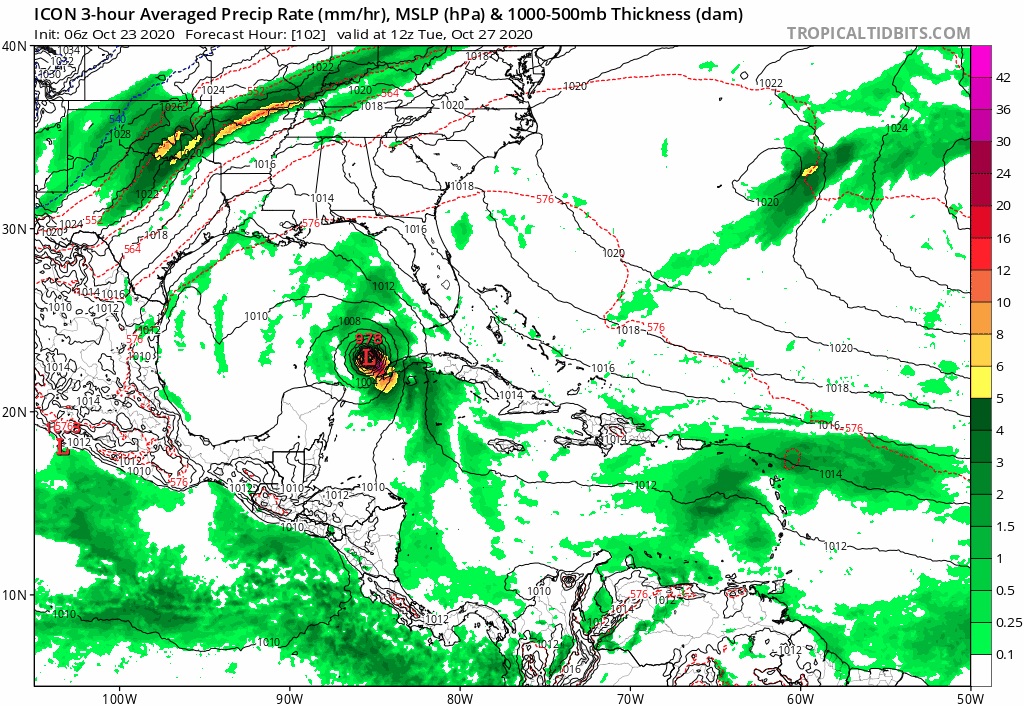
06z ICON...
0 likes
Hurricane Eye Experience: David 79, Irene 99, Frances 04, Jeanne 04, Wilma 05...
Hurricane Brush Experience: Andrew 92, Erin 95, Floyd 99, Matthew 16, Irma 17, Ian 22, Nicole 22…
Hurricane Brush Experience: Andrew 92, Erin 95, Floyd 99, Matthew 16, Irma 17, Ian 22, Nicole 22…
-
Blown Away
- S2K Supporter
- Posts: 9863
- Joined: Wed May 26, 2004 6:17 am
Re: ATL: INVEST 95L - Models

00z Euro... Seems to split the energy sending N half through SFL and S half into the GOM...
0 likes
Hurricane Eye Experience: David 79, Irene 99, Frances 04, Jeanne 04, Wilma 05...
Hurricane Brush Experience: Andrew 92, Erin 95, Floyd 99, Matthew 16, Irma 17, Ian 22, Nicole 22…
Hurricane Brush Experience: Andrew 92, Erin 95, Floyd 99, Matthew 16, Irma 17, Ian 22, Nicole 22…

Re: ATL: INVEST 95L - Models
06z HMON, TS/cat 1 landfall in Cuba followed by a cat 1 landfall in Florida with a peak as a cat 2 before its 2nd landfall.
0 likes
-
Blown Away
- S2K Supporter
- Posts: 9863
- Joined: Wed May 26, 2004 6:17 am
Re: ATL: INVEST 95L - Models

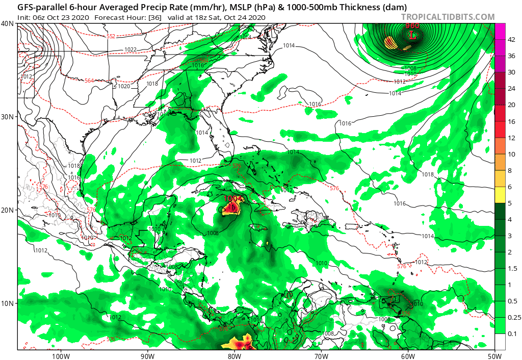
06z HMON... Cat 2 into SFL in 4-5 days...
0 likes
Hurricane Eye Experience: David 79, Irene 99, Frances 04, Jeanne 04, Wilma 05...
Hurricane Brush Experience: Andrew 92, Erin 95, Floyd 99, Matthew 16, Irma 17, Ian 22, Nicole 22…
Hurricane Brush Experience: Andrew 92, Erin 95, Floyd 99, Matthew 16, Irma 17, Ian 22, Nicole 22…
-
SouthFLTropics

- Category 5
- Posts: 4156
- Age: 48
- Joined: Thu Aug 14, 2003 8:04 am
- Location: Port St. Lucie, Florida
Re: ATL: INVEST 95L - Models
06z Para is spinning this up south of Cuba and bringing it north through 60 hours.
Sent from my iPhone using Tapatalk
Sent from my iPhone using Tapatalk
2 likes
Fourth Generation Floridian...With lots of storm knowledge passed down from my elders...
Personal Storm History: David 79, Andrew 92, Erin 95, Floyd 99, Irene 99, Frances 04, Jeanne 04, Wilma 05, Matthew 16, Irma 17
Personal Storm History: David 79, Andrew 92, Erin 95, Floyd 99, Irene 99, Frances 04, Jeanne 04, Wilma 05, Matthew 16, Irma 17
-
Iceresistance

- Category 5
- Posts: 8915
- Age: 20
- Joined: Sat Oct 10, 2020 9:45 am
- Location: Tecumseh, OK/Norman, OK
Re: ATL: INVEST 95L - Models
Woah! I never expected this.
0 likes
Bill 2015 & Beta 2020
Winter 2020-2021
All observations are in Tecumseh, OK unless otherwise noted.
Winter posts are focused mainly for Oklahoma & Texas.
Take any of my forecasts with a grain of salt, refer to the NWS, SPC, and NHC for official information
Never say Never with weather! Because ANYTHING is possible!
Winter 2020-2021
All observations are in Tecumseh, OK unless otherwise noted.
Winter posts are focused mainly for Oklahoma & Texas.
Take any of my forecasts with a grain of salt, refer to the NWS, SPC, and NHC for official information
Never say Never with weather! Because ANYTHING is possible!
-
Iceresistance
- Category 5
- Posts: 8915
- Age: 20
- Joined: Sat Oct 10, 2020 9:45 am
- Location: Tecumseh, OK/Norman, OK
Re: ATL: INVEST 95L - Models
Very Aggressive with this one, that is a CAT 2 for sure with the 6z ICON model.
0 likes
Bill 2015 & Beta 2020
Winter 2020-2021
All observations are in Tecumseh, OK unless otherwise noted.
Winter posts are focused mainly for Oklahoma & Texas.
Take any of my forecasts with a grain of salt, refer to the NWS, SPC, and NHC for official information
Never say Never with weather! Because ANYTHING is possible!
Winter 2020-2021
All observations are in Tecumseh, OK unless otherwise noted.
Winter posts are focused mainly for Oklahoma & Texas.
Take any of my forecasts with a grain of salt, refer to the NWS, SPC, and NHC for official information
Never say Never with weather! Because ANYTHING is possible!

Re: ATL: INVEST 95L - Models
0 likes
Re: ATL: INVEST 95L - Models
ICON and now also the GFS ensemble with a significant west shift to the point where a Gulf storm without Cuba interaction (or only minor interaction) might become a serious scenario. But there are still a lot of options possible from the HMON solution directly over central Cuba and into the eastern part of SFL or a Gulf storm with possible landfalls in western SFL or even the Panhandle. Or nothing could form at all. Either way, interesting days ahead.
2 likes
Re: ATL: INVEST 95L - Models
06z HWRF...gets low pressure down to 1005 mb or so near Cuba but weakens it as it moves north in the eastern GOM (go figure for once it doesn't overdo intensity).
https://www.tropicaltidbits.com/analysis/models/?model=hwrf®ion=95L&pkg=mslp_pcpn_frzn&runtime=2020102306&fh=6
https://www.tropicaltidbits.com/analysis/models/?model=hwrf®ion=95L&pkg=mslp_pcpn_frzn&runtime=2020102306&fh=6
0 likes
-
SconnieCane
- Category 4

- Posts: 913
- Joined: Thu Aug 02, 2018 5:29 pm
- Location: Madison, WI
Re: ATL: INVEST 95L - Models
HMON seems to take it straight north too quickly. I'd expect it to cross Cuba near the western tip, resulting in much less disruption assuming it's an established cyclone by then.
Meanwhle, EURO appears to want to take it into (where else? ) SW LA.
Meanwhle, EURO appears to want to take it into (where else?
0 likes
-
northjaxpro

- S2K Supporter
- Posts: 8900
- Joined: Mon Sep 27, 2010 11:21 am
- Location: Jacksonville, FL
Re: ATL: INVEST 95L - Models
The west shift is a major concern, if the models keep trending in that direction. This would give 95L more time to organize and feed over very warm ssts. I am growing more concerned if this actually plays out this weekend.
0 likes
NEVER, EVER SAY NEVER in the tropics and weather in general, and most importantly, with life itself!!
________________________________________________________________________________________
Fay 2008 Beryl 2012 Debby 2012 Colin 2016 Hermine 2016 Julia 2016 Matthew 2016 Irma 2017 Dorian 2019
________________________________________________________________________________________
Fay 2008 Beryl 2012 Debby 2012 Colin 2016 Hermine 2016 Julia 2016 Matthew 2016 Irma 2017 Dorian 2019
Re: ATL: INVEST 95L - Models
kevin wrote:ICON and now also the GFS ensemble with a significant west shift to the point where a Gulf storm without Cuba interaction (or only minor interaction) might become a serious scenario. But there are still a lot of options possible from the HMON solution directly over central Cuba and into the eastern part of SFL or a Gulf storm with possible landfalls in western SFL or even the Panhandle. Or nothing could form at all. Either way, interesting days ahead.
NHC now moving their orange development area at 50/60% into the SE GOM at 8 am TWO.
2 likes
-
northjaxpro
- S2K Supporter
- Posts: 8900
- Joined: Mon Sep 27, 2010 11:21 am
- Location: Jacksonville, FL
Re: ATL: INVEST 95L - Models
ronjon wrote:06z HWRF...gets low pressure down to 1005 mb or so near Cuba but weakens it as it moves north in the eastern GOM (go figure for once it doesn't overdo intensity).
https://www.tropicaltidbits.com/analysis/models/?model=hwrf®ion=95L&pkg=mslp_pcpn_frzn&runtime=2020102306&fh=6
I would not buy into this. Surprised the HWRF is being less aggressive about this on this run. I bet this changes as time progresses.
0 likes
NEVER, EVER SAY NEVER in the tropics and weather in general, and most importantly, with life itself!!
________________________________________________________________________________________
Fay 2008 Beryl 2012 Debby 2012 Colin 2016 Hermine 2016 Julia 2016 Matthew 2016 Irma 2017 Dorian 2019
________________________________________________________________________________________
Fay 2008 Beryl 2012 Debby 2012 Colin 2016 Hermine 2016 Julia 2016 Matthew 2016 Irma 2017 Dorian 2019
-
gatorcane

- S2K Supporter
- Posts: 23499
- Age: 46
- Joined: Sun Mar 13, 2005 3:54 pm
- Location: Boca Raton, FL
Re: ATL: INVEST 95L - Models
Missing frames GFS-P, around peninsula Florida it goes, landfall in the panhandle.
0 likes
-
Iceresistance
- Category 5
- Posts: 8915
- Age: 20
- Joined: Sat Oct 10, 2020 9:45 am
- Location: Tecumseh, OK/Norman, OK
Re: ATL: INVEST 95L - Models
ronjon wrote:kevin wrote:ICON and now also the GFS ensemble with a significant west shift to the point where a Gulf storm without Cuba interaction (or only minor interaction) might become a serious scenario. But there are still a lot of options possible from the HMON solution directly over central Cuba and into the eastern part of SFL or a Gulf storm with possible landfalls in western SFL or even the Panhandle. Or nothing could form at all. Either way, interesting days ahead.
NHC now moving their orange development area at 50/60% into the SE GOM at 8 am TWO.
Yesterday, it was at 10-30, it really improved overnight, literally.
0 likes
Bill 2015 & Beta 2020
Winter 2020-2021
All observations are in Tecumseh, OK unless otherwise noted.
Winter posts are focused mainly for Oklahoma & Texas.
Take any of my forecasts with a grain of salt, refer to the NWS, SPC, and NHC for official information
Never say Never with weather! Because ANYTHING is possible!
Winter 2020-2021
All observations are in Tecumseh, OK unless otherwise noted.
Winter posts are focused mainly for Oklahoma & Texas.
Take any of my forecasts with a grain of salt, refer to the NWS, SPC, and NHC for official information
Never say Never with weather! Because ANYTHING is possible!
Who is online
Users browsing this forum: No registered users and 33 guests