HWRF
Time (hr) / MSLP (mb) / Wind (kt)
00 / 1004 / 42
03 / 1002 / 40
06 / 995 / 46
09 / 989 / 58
12 / 989 / 55
15 / 988 / 54
18 / 986 / 56
21 / 981 / 63
24 / 982 / 63
27 / 983 / 62
30 / 977 / 60
33 / 973 / 58
36 / 970 / 73 <- cat 1
39 / 967 / 68
42 / 960 / 83
45 / 954 / 82
48 / 949 / 84 <- cat 2
51 / 949 / 86
54 / 947 / 93
57 / 942 / 102 <- cat 3
60 / 938 / 110
63 / 940 / 110
66 / 940 / 108
69 / 943 / 105 <- Honduras landfall, inland
72 / 948 / 101 - inland
---- inland
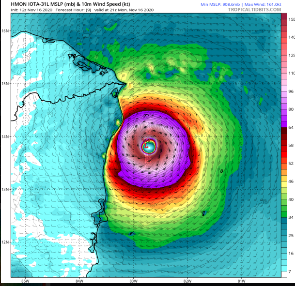
HMON
Time (hr) / MSLP (mb) / Wind (kt)
00 / 1006 / 32
03 / 1002 / 43
06 / 998 / 44
09 / 994 / 43
12 / 995 / 50
15 / 992 / 51
18 / 986 / 56
21 / 983 / 65 <- cat 1
24 / 983 / 69
27 / 980 / 70
30 / 976 / 70
33 / 973 / 71
36 / 967 / 74
39 / 962 / 76
42 / 956 / 86 <- cat 2
45 / 952 / 92
48 / 952 / 95
51 / 950 / 96 <- cat 3
54 / 945 / 103
57 / 937 / 109
60 / 930 / 136 <- cat 4
63 / 938 / 111 <- Nicaragua landfall, inland
66 / 957 / 66 - inland
---- inland