It appears that Sam has wobbled to look like it's moving at 0°, which is straight north
Edit: Wrong Coordinate calculation, oops
ATL: SAM - Remnants - Discussion
Moderator: S2k Moderators
-
Iceresistance

- Category 5

- Posts: 9592
- Age: 22
- Joined: Sat Oct 10, 2020 9:45 am
- Location: Tecumseh, OK/Norman, OK
Re: ATL: SAM - Hurricane - Discussion
Last edited by Iceresistance on Sun Sep 26, 2021 10:50 am, edited 1 time in total.
0 likes
Bill 2015 & Beta 2020
Winter 2020-2021
All observations are in Tecumseh, OK unless otherwise noted.
Winter posts are focused mainly for Oklahoma & Texas.
Take any of my forecasts with a grain of salt, refer to the NWS, SPC, and NHC for official information
Never say Never with weather! Because ANYTHING is possible!
Winter 2020-2021
All observations are in Tecumseh, OK unless otherwise noted.
Winter posts are focused mainly for Oklahoma & Texas.
Take any of my forecasts with a grain of salt, refer to the NWS, SPC, and NHC for official information
Never say Never with weather! Because ANYTHING is possible!

Re: ATL: SAM - Hurricane - Discussion
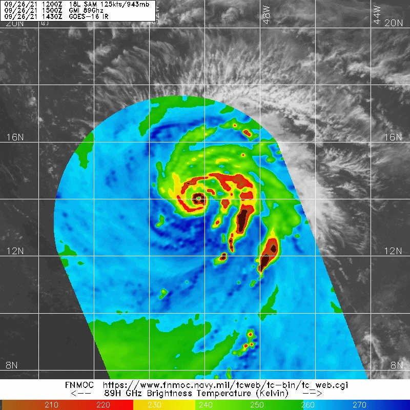
Yellow Evan wrote:While eye temperatures and cloud top temperatures are similar to what they were yesterday, symmetry seems to still be improving. Probably on the doorstep of Category 5 though satellite estimates don’t support it.
I notice 2 more possible systems behind Sam on our map at the top of each page. As Sam
slows down, any chance these catch up and have an affect on Sam or each other?
0 likes
-
Sciencerocks
- Category 5
- Posts: 10186
- Age: 40
- Joined: Thu Jul 06, 2017 1:51 am


Re: ATL: SAM - Hurricane - Discussion
Iceresistance wrote:It appears that Sam has wobbled to look like it's moving at 0°, which is straight north
It looks like Sam is wobbling due west the last few hours (270 degrees).
0 likes

Re: ATL: SAM - Hurricane - Discussion
I fail to see how this isn't at least 130 kt. Clearly intensified since the recon mission and had a more impressive look for a few hours now, so even if you treat the recon intensity as 125 kt, this could easily be 130 kt now. If you think recon indicated more of a 130-135 kt storm, this might be a Cat 5 already.
3 likes
TC naming lists: retirements and intensity
Most aggressive Advisory #1's in North Atlantic (cr. kevin for starting the list)
Most aggressive Advisory #1's in North Atlantic (cr. kevin for starting the list)
-
Stormybajan

- Category 1

- Posts: 453
- Joined: Thu May 20, 2021 3:21 pm
- Location: Windward Islands
Re: ATL: SAM - Hurricane - Discussion
For me, its been at 130 knot intensity for about 20 hours now. Right now its a toss up between 130-135 knots, especially with that extremely dry eye signature, not sure why Sam is still 125 knots for the NHC. Im hoping in post season it gets a well deserved uptick in intensity in post season
0 likes
Sad West Indies and Manchester United fan ⚽️
-
Yellow Evan

- Professional-Met

- Posts: 16240
- Age: 27
- Joined: Fri Jul 15, 2011 12:48 pm
- Location: Henderson, Nevada/Honolulu, HI
- Contact:
Re: ATL: SAM - Hurricane - Discussion
----- Current Analysis -----
Date : 26 SEP 2021 Time : 145020 UTC
Lat : 13:55:12 N Lon : 50:06:36 W
CI# /Pressure/ Vmax
6.4 / 944.0mb/124.6kt
Final T# Adj T# Raw T#
6.4 6.6 6.6
Estimated radius of max. wind based on IR : 13 km
Center Temp : +18.0C Cloud Region Temp : -69.5C
Scene Type : EYE
Date : 26 SEP 2021 Time : 145020 UTC
Lat : 13:55:12 N Lon : 50:06:36 W
CI# /Pressure/ Vmax
6.4 / 944.0mb/124.6kt
Final T# Adj T# Raw T#
6.4 6.6 6.6
Estimated radius of max. wind based on IR : 13 km
Center Temp : +18.0C Cloud Region Temp : -69.5C
Scene Type : EYE
0 likes


Re: ATL: SAM - Hurricane - Discussion
The outer bands need to hold off for just 7 more hours…
0 likes
Irene '11 Sandy '12 Hermine '16 5/15/2018 Derecho Fay '20 Isaias '20 Elsa '21 Henri '21 Ida '21
I am only a meteorology enthusiast who knows a decent amount about tropical cyclones. Look to the professional mets, the NHC, or your local weather office for the best information.
I am only a meteorology enthusiast who knows a decent amount about tropical cyclones. Look to the professional mets, the NHC, or your local weather office for the best information.


-
Yellow Evan
- Professional-Met
- Posts: 16240
- Age: 27
- Joined: Fri Jul 15, 2011 12:48 pm
- Location: Henderson, Nevada/Honolulu, HI
- Contact:


Re: ATL: SAM - Hurricane - Discussion
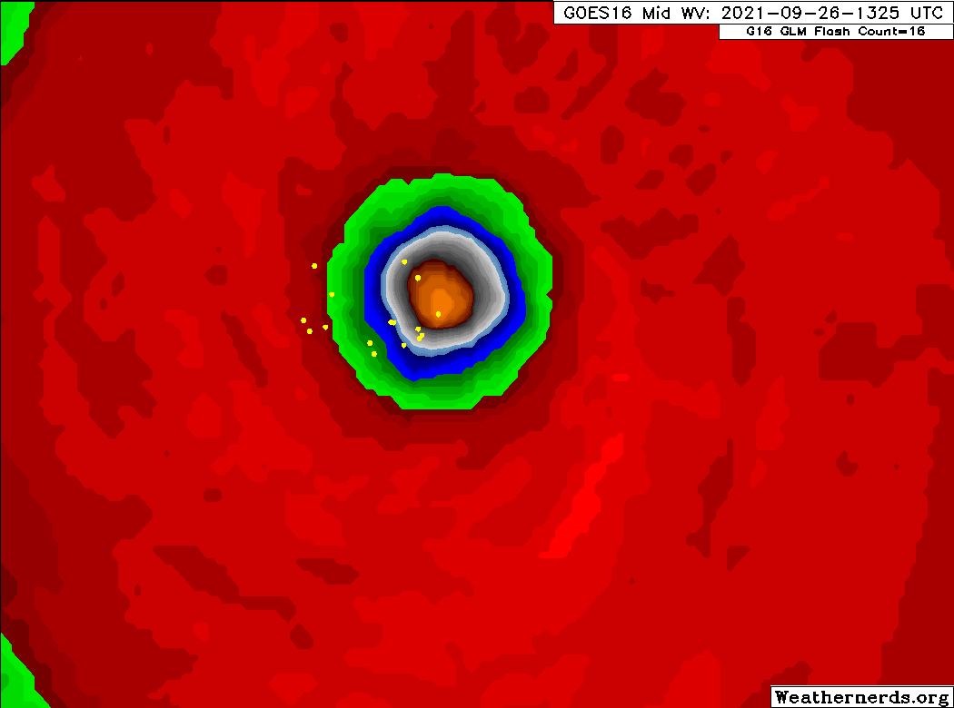
While Sam's IR appearance has been pretty steady the last few hours, the eye has dried out significantly on WV satellite. This is a clear indication that Sam is in fact strengthening right now. A drier eye means there's more subsidence, which contributes to a stronger warm core. A drying eye is often a good indicator of strengthening in upper-end storms, e.g. I remember this happening w/ Dorian before the strongest recon passes. Not to say Sam is that strong, but a very plausible case for Cat 5 can be made.

4 likes
I'm a busy grad student, not a professional forecaster. Please refer to the NHC and NWS for official forecasts.
Re: ATL: SAM - Hurricane - Discussion
Sam’s current location can support pressures down to 930-925mb. It’s possible it is close to those MPIs now, and even if an outer eyewall successfully forms before recon arrives, the inner eyewall is potent enough that significant weakening is unlikely.
If Sam does visibly weaken before recon arrives, then this will go down as one of the worst recon schedules ever.
If Sam does visibly weaken before recon arrives, then this will go down as one of the worst recon schedules ever.
1 likes
Irene '11 Sandy '12 Hermine '16 5/15/2018 Derecho Fay '20 Isaias '20 Elsa '21 Henri '21 Ida '21
I am only a meteorology enthusiast who knows a decent amount about tropical cyclones. Look to the professional mets, the NHC, or your local weather office for the best information.
I am only a meteorology enthusiast who knows a decent amount about tropical cyclones. Look to the professional mets, the NHC, or your local weather office for the best information.

Re: ATL: SAM - Hurricane - Discussion
I think that for the first time in its life this might actually be a 140kt cat 5 right now. I estimated 130-135 kt for the original peak yesterday, but this looks very T7.0 right now. As aspen mentioned even if the outer eyewall starts forming the inner one should hopefully still be stable enough to survive at peak strength until well after recon arrives.
0 likes
Re: ATL: SAM - Hurricane - Discussion
aspen wrote:Sam’s current location can support pressures down to 930-925mb. It’s possible it is close to those MPIs now, and even if an outer eyewall successfully forms before recon arrives, the inner eyewall is potent enough that significant weakening is unlikely.
If Sam does visibly weaken before recon arrives, then this will go down as one of the worst recon schedules ever.
Yes true. But even if recon finds a weakened storm I think a very strong case for 140 kt can be made in post-season analysis, especially if f.e. after some weakening recon still finds 135 kt or something like that. Even though I'd rather have a cat 5 announcement today instead of a possible designation 1 year later.
0 likes
-
Iceresistance
- Category 5
- Posts: 9592
- Age: 22
- Joined: Sat Oct 10, 2020 9:45 am
- Location: Tecumseh, OK/Norman, OK
Re: ATL: SAM - Hurricane - Discussion
aspen wrote:
The outer bands need to hold off for just 7 more hours…
Or do the EWRC quicker so it can recover faster . . .
0 likes
Bill 2015 & Beta 2020
Winter 2020-2021
All observations are in Tecumseh, OK unless otherwise noted.
Winter posts are focused mainly for Oklahoma & Texas.
Take any of my forecasts with a grain of salt, refer to the NWS, SPC, and NHC for official information
Never say Never with weather! Because ANYTHING is possible!
Winter 2020-2021
All observations are in Tecumseh, OK unless otherwise noted.
Winter posts are focused mainly for Oklahoma & Texas.
Take any of my forecasts with a grain of salt, refer to the NWS, SPC, and NHC for official information
Never say Never with weather! Because ANYTHING is possible!
-
ElectricStorm

- Category 5
- Posts: 5147
- Age: 25
- Joined: Tue Aug 13, 2019 11:23 pm
- Location: Norman, OK
Re: ATL: SAM - Hurricane - Discussion
I'd probably put this at 135-140 kts right now, although I'm hesitant to 140 without any direct measurements. Hopefully it holds until recon gets there.
0 likes
B.S Meteorology, University of Oklahoma '25
Please refer to the NHC, NWS, or SPC for official information.
Please refer to the NHC, NWS, or SPC for official information.
-
KirbyDude25

- Tropical Storm

- Posts: 161
- Age: 21
- Joined: Mon Sep 20, 2021 8:03 am
- Location: Westfield, New Jersey
Re: ATL: SAM - Hurricane - Discussion
Owasso wrote:https://i.postimg.cc/jjwf0JVz/1-B4125-B2-617-B-4-BFE-82-DD-6179-A709-B75-E.gif
Dark red eye alert.
What does dark red in the eye mean? I assume it means that the eye is really warm, but how warm exactly?
0 likes
New Jersey, Rutgers '27
Irene 2011 | Sandy 2012 | Fay 2020 | Isaias 2020 | Ida 2021
Irene 2011 | Sandy 2012 | Fay 2020 | Isaias 2020 | Ida 2021
Who is online
Users browsing this forum: No registered users and 50 guests