ATL: SAM - Remnants - Discussion
Moderator: S2k Moderators

Re: ATL: SAM - Hurricane - Discussion
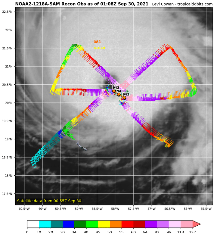
128kt dropsonde, 133kt FL, and 122kt SFMR from this pass support a 120 kt Cat 4. If Sam’s structure continues to improve, the NHC might go with 125 kt instead.
3 likes
Irene '11 Sandy '12 Hermine '16 5/15/2018 Derecho Fay '20 Isaias '20 Elsa '21 Henri '21 Ida '21
I am only a meteorology enthusiast who knows a decent amount about tropical cyclones. Look to the professional mets, the NHC, or your local weather office for the best information.
I am only a meteorology enthusiast who knows a decent amount about tropical cyclones. Look to the professional mets, the NHC, or your local weather office for the best information.
-
InfernoFlameCat

- Category 5

- Posts: 2127
- Age: 22
- Joined: Mon Dec 14, 2020 10:52 am
- Location: Buford, GA
Re: ATL: SAM - Hurricane - Discussion
This could end up being the peak pressure here, if not the peak winds. If the storm keeps strengthening of course.
0 likes
I am by no means a professional. DO NOT look at my forecasts for official information or make decisions based on what I post.
Goal: to become a registered expert over tropical and subtropical cyclones.
Goal: to become a registered expert over tropical and subtropical cyclones.
-
grapealcoholic
- Category 2

- Posts: 703
- Joined: Tue Aug 10, 2021 3:26 pm
Re: ATL: SAM - Hurricane - Discussion
InfernoFlameCat wrote:This could end up being the peak pressure here, if not the peak winds. If the storm keeps strengthening of course.
I think it will peak in around 12 hours
0 likes
-
cycloneye

- Admin

- Posts: 149511
- Age: 69
- Joined: Thu Oct 10, 2002 10:54 am
- Location: San Juan, Puerto Rico
Re: ATL: SAM - Hurricane - Discussion
0 likes
Visit the Caribbean-Central America Weather Thread where you can find at first post web cams,radars
and observations from Caribbean basin members Click Here
and observations from Caribbean basin members Click Here
-
cheezyWXguy

- Category 5
- Posts: 6282
- Joined: Mon Feb 13, 2006 12:29 am
- Location: Dallas, TX
Re: ATL: SAM - Hurricane - Discussion
Outer bands are retracting and the cdo is becoming more symmetrical. We might see that transition to annular I was wondering about a day or two ago if this keeps up.
0 likes


-
Hypercane_Kyle

- Category 5
- Posts: 3465
- Joined: Sat Mar 07, 2015 7:58 pm
- Location: Cape Canaveral, FL
Re: ATL: SAM - Hurricane - Discussion
Real chance Sam might make another go at Cat 5 status tonight. Will be interesting to watch!
0 likes
My posts are my own personal opinion, defer to the National Hurricane Center (NHC) and other NOAA products for decision making during hurricane season.

Re: ATL: SAM - Hurricane - Discussion
Recon doesn't seem to be done with Sam yet. Fourth pass incoming.
1 likes
Re: ATL: SAM - Hurricane - Discussion
The next set should have winds from the S eyewall and pressure from the eye itself.
0 likes
Irene '11 Sandy '12 Hermine '16 5/15/2018 Derecho Fay '20 Isaias '20 Elsa '21 Henri '21 Ida '21
I am only a meteorology enthusiast who knows a decent amount about tropical cyclones. Look to the professional mets, the NHC, or your local weather office for the best information.
I am only a meteorology enthusiast who knows a decent amount about tropical cyclones. Look to the professional mets, the NHC, or your local weather office for the best information.
-
grapealcoholic
- Category 2
- Posts: 703
- Joined: Tue Aug 10, 2021 3:26 pm

Re: ATL: SAM - Hurricane - Discussion
Extrap pressure 939.9mb, S eyewall has FL winds 121 kts and SFMR 120 kts.
0 likes
TC naming lists: retirements and intensity
Most aggressive Advisory #1's in North Atlantic (cr. kevin for starting the list)
Most aggressive Advisory #1's in North Atlantic (cr. kevin for starting the list)

Re: ATL: SAM - Hurricane - Discussion
138kt flight level on the north side.
0 likes
Kendall -> SLO -> PBC
Memorable Storms: Katrina (for its Florida landfall...) Wilma Matthew Irma
Memorable Storms: Katrina (for its Florida landfall...) Wilma Matthew Irma
Re: ATL: SAM - Hurricane - Discussion
If Sam’s current core and outflow structure remains, it’ll probably be back up to 130 kt by tomorrow morning at this rate. The 90% conversion factor already supports 125 kt, based on those 138 kt FL winds. I think some SFMR readings did get above 120 kt during a previous pass.
0 likes
Irene '11 Sandy '12 Hermine '16 5/15/2018 Derecho Fay '20 Isaias '20 Elsa '21 Henri '21 Ida '21
I am only a meteorology enthusiast who knows a decent amount about tropical cyclones. Look to the professional mets, the NHC, or your local weather office for the best information.
I am only a meteorology enthusiast who knows a decent amount about tropical cyclones. Look to the professional mets, the NHC, or your local weather office for the best information.
-
Hypercane_Kyle
- Category 5
- Posts: 3465
- Joined: Sat Mar 07, 2015 7:58 pm
- Location: Cape Canaveral, FL
Re: ATL: SAM - Hurricane - Discussion
125 knots looks like a good estimate to me based on that pass.
1 likes
My posts are my own personal opinion, defer to the National Hurricane Center (NHC) and other NOAA products for decision making during hurricane season.
-
cycloneye
- Admin
- Posts: 149511
- Age: 69
- Joined: Thu Oct 10, 2002 10:54 am
- Location: San Juan, Puerto Rico
Re: ATL: SAM - Hurricane - Discussion
0 likes
Visit the Caribbean-Central America Weather Thread where you can find at first post web cams,radars
and observations from Caribbean basin members Click Here
and observations from Caribbean basin members Click Here


-
InfernoFlameCat
- Category 5
- Posts: 2127
- Age: 22
- Joined: Mon Dec 14, 2020 10:52 am
- Location: Buford, GA
Re: ATL: SAM - Hurricane - Discussion
This is fantastic recon. Congrats to the NHC!
0 likes
I am by no means a professional. DO NOT look at my forecasts for official information or make decisions based on what I post.
Goal: to become a registered expert over tropical and subtropical cyclones.
Goal: to become a registered expert over tropical and subtropical cyclones.
Re: ATL: SAM - Hurricane - Discussion
INIT 30/0300Z 20.6N 58.4W 125 KT 145 MPH
12H 30/1200Z 21.9N 59.6W 130 KT 150 MPH
24H 01/0000Z 24.1N 60.9W 125 KT 145 MPH
36H 01/1200Z 26.8N 61.8W 120 KT 140 MPH
48H 02/0000Z 29.6N 61.8W 115 KT 130 MPH
60H 02/1200Z 32.2N 60.7W 110 KT 125 MPH
72H 03/0000Z 34.3N 59.2W 100 KT 115 MPH
96H 04/0000Z 37.5N 54.5W 85 KT 100 MPH
120H 05/0000Z 42.0N 48.5W 70 KT 80 MPH
2 likes
-
grapealcoholic
- Category 2
- Posts: 703
- Joined: Tue Aug 10, 2021 3:26 pm
Who is online
Users browsing this forum: No registered users and 82 guests