ATL: FRED - Post-Tropical - Discussion
Moderator: S2k Moderators

Re: ATL: FRED - Tropical Storm - Discussion
NHC is finding that the LLC is further NE than estimated to be at 4 AM CDT advisory.
0 likes
Re: ATL: FRED - Tropical Storm - Discussion
Extrap pressure down in to the mid 990s mb.
115330 2832N 08541W 9254 00677 9997 +234 +073 314031 032 034 001 00
115400 2833N 08540W 9249 00675 9987 +240 +074 310037 038 042 001 00
115430 2834N 08538W 9250 00661 9970 +251 +075 296036 039 042 001 00
115500 2836N 08537W 9248 00652 9956 +265 +076 277034 037 038 001 00
115530 2837N 08536W 9241 00653 9948 +268 +078 260026 031 029 001 00
115600 2839N 08535W 9242 00648 9945 +263 +081 255022 026 028 001 00
115630 2840N 08534W 9268 00616 9943 +240 +082 242014 017 027 002 00
$$
;
0 likes

Re: ATL: FRED - Tropical Storm - Discussion
Can’t believe how will it looks on satellite this morning compared to this time yesterday, think a hurricane is on the card now unfortunately
0 likes
Re: ATL: FRED - Tropical Storm - Discussion
Let’s see how the NE side looks when the next data set comes in.
0 likes
-
Dean4Storms
- S2K Supporter

- Posts: 6358
- Age: 63
- Joined: Sun Aug 31, 2003 1:01 pm
- Location: Miramar Bch. FL
Re: ATL: FRED - Tropical Storm - Discussion
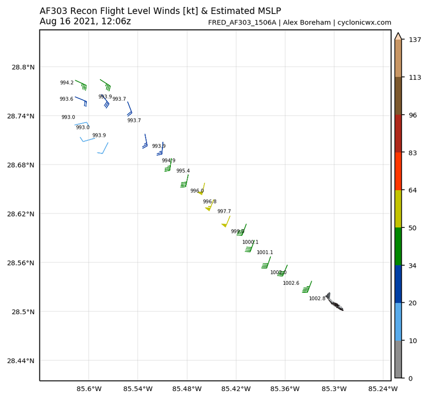
Am I seeing 50kt flight level winds west of the center?
0 likes
-
tolakram
- Admin

- Posts: 20186
- Age: 62
- Joined: Sun Aug 27, 2006 8:23 pm
- Location: Florence, KY (name is Mark)
Re: ATL: FRED - Tropical Storm - Discussion
Most models now saying close to if not a minimal hurricane.
Fred now has floater status again. Hopefully folks in that area are prepared.
https://weather.cod.edu/satrad/?parms=meso-meso2-02-24-0-100-1&checked=map&colorbar=undefined
Fred now has floater status again. Hopefully folks in that area are prepared.
https://weather.cod.edu/satrad/?parms=meso-meso2-02-24-0-100-1&checked=map&colorbar=undefined
0 likes
M a r k
- - - - -
Join us in chat: Storm2K Chatroom Invite. Android and IOS apps also available.
The posts in this forum are NOT official forecasts and should not be used as such. Posts are NOT endorsed by any professional institution or STORM2K.org. For official information and forecasts, please refer to NHC and NWS products.


Re: ATL: FRED - Tropical Storm - Discussion
anyone have a satellite comparison of this morning and Saturday AM Incredible what the GOM can do. And to think its only th 16th of AUG. 
1 likes
Once I see the REDS and GREENS Converge on a Base Velocity. ... I'm There!!
This is NOT an Official Forecast....Just my Opinion. For official information, please refer to the NHC and NWS products.
HIGHLIGHTS : '13 El Reno Tornado : 2013 Storm Chaser Tour, Joaquin; SC flood event, Matthew '16, Lowcountry Snow storm Jan '18
This is NOT an Official Forecast....Just my Opinion. For official information, please refer to the NHC and NWS products.
HIGHLIGHTS : '13 El Reno Tornado : 2013 Storm Chaser Tour, Joaquin; SC flood event, Matthew '16, Lowcountry Snow storm Jan '18
Re: ATL: FRED - Tropical Storm - Discussion
8am (7cst) pressure 1002. Recon reports 994... ?
0 likes

Re: ATL: FRED - Tropical Storm - Discussion
Kohlecane wrote:anyone have a satellite comparison of this morning and Saturday AM Incredible what the GOM can do. And to think its only th 16th of AUG.
Yeah if the Gulf can change Fred in one day from a mess to a formidable TS, I'm afraid of what September will bring.
Last edited by kevin on Mon Aug 16, 2021 7:09 am, edited 1 time in total.
0 likes
-
tolakram
- Admin
- Posts: 20186
- Age: 62
- Joined: Sun Aug 27, 2006 8:23 pm
- Location: Florence, KY (name is Mark)
Re: ATL: FRED - Tropical Storm - Discussion

1 likes
M a r k
- - - - -
Join us in chat: Storm2K Chatroom Invite. Android and IOS apps also available.
The posts in this forum are NOT official forecasts and should not be used as such. Posts are NOT endorsed by any professional institution or STORM2K.org. For official information and forecasts, please refer to NHC and NWS products.
- - - - -
Join us in chat: Storm2K Chatroom Invite. Android and IOS apps also available.
The posts in this forum are NOT official forecasts and should not be used as such. Posts are NOT endorsed by any professional institution or STORM2K.org. For official information and forecasts, please refer to NHC and NWS products.
Re: ATL: FRED - Tropical Storm - Discussion
55 knots at flight level in the SE quadrant, I am sure the NE quadrant will be stronger.
URNT15 KNHC 161206
AF303 1506A FRED HDOB 10 20210816
115700 2842N 08535W 9250 00629 9939 +222 +081 207010 014 024 006 03
115730 2843N 08536W 9254 00618 9930 +234 +077 254004 010 027 008 03
115800 2844N 08537W 9248 00625 9930 +236 +071 077007 011 023 007 03
115830 2846N 08537W 9243 00633 9936 +231 +067 112018 022 026 003 00
115900 2847N 08537W 9267 00614 9942 +222 +065 115031 035 /// /// 03
115930 2847N 08535W 9239 00636 9939 +226 +063 123030 035 046 003 00
120000 2846N 08535W 9270 00609 9937 +230 +063 141028 032 044 006 00
120030 2845N 08533W 9243 00635 9937 +233 +063 159023 024 039 004 00
120100 2843N 08532W 9255 00622 9939 +232 +063 169024 025 036 005 00
120130 2842N 08531W 9251 00635 9949 +221 +063 185024 026 039 002 00
120200 2841N 08530W 9250 00642 9954 +231 +062 188032 035 040 002 00
120230 2840N 08529W 9252 00646 9960 +239 +062 192042 044 045 001 00
120300 2839N 08528W 9260 00649 9968 +246 +063 193049 051 046 001 00
120330 2838N 08527W 9251 00665 9977 +249 +065 201052 055 046 001 00
120400 2837N 08526W 9254 00672 9990 +243 +068 202050 054 046 001 00
120430 2836N 08525W 9263 00672 0001 +238 +069 201046 048 044 001 00
120500 2835N 08524W 9248 00694 0011 +224 +069 200041 044 040 001 00
120530 2834N 08523W 9254 00694 0020 +216 +068 199041 042 040 000 00
120600 2833N 08522W 9248 00703 0026 +211 +065 203041 042 040 001 00
120630 2832N 08520W 9255 00700 0028 +223 +063 201045 048 041 001 00
$$
;
1 likes
Re: ATL: FRED - Tropical Storm - Discussion
wx98 wrote:Let’s see how the NE side looks when the next data set comes in.
Oops, nevermind. They went SE first.
0 likes


Re: ATL: FRED - Tropical Storm - Discussion
The radar shows the best velocities in the NE quadrant.
0 likes
Re: ATL: FRED - Tropical Storm - Discussion
Kohlecane wrote:anyone have a satellite comparison of this morning and Saturday AM Incredible what the GOM can do. And to think its only th 16th of AUG.
The GOM doing its magic.

6 likes

Re: ATL: FRED - Tropical Storm - Discussion
Sure looks like this is gonna make a run for hurricane status by landfall. Consistent hot towers are firing over and over again right where recon found the LLC, so I expect this to continue deepening.
1 likes
Irene '11 Sandy '12 Hermine '16 5/15/2018 Derecho Fay '20 Isaias '20 Elsa '21 Henri '21 Ida '21
I am only a meteorology enthusiast who knows a decent amount about tropical cyclones. Look to the professional mets, the NHC, or your local weather office for the best information.
I am only a meteorology enthusiast who knows a decent amount about tropical cyclones. Look to the professional mets, the NHC, or your local weather office for the best information.
Re: ATL: FRED - Tropical Storm - Discussion
NDG wrote:Kohlecane wrote:anyone have a satellite comparison of this morning and Saturday AM Incredible what the GOM can do. And to think its only th 16th of AUG.
The GOM doing its magic.
https://i.imgur.com/4qu7XSj.gif
Not difficult to see why if you look at the hurricane potential map. Don't think I've ever seen a GOM that's this darkly colored in August. Large swaths of the GOM could theoretically already support sub-880 mbar systems.

1 likes
-
Shell Mound
- Category 5

- Posts: 2432
- Age: 33
- Joined: Thu Sep 07, 2017 3:39 pm
- Location: St. Petersburg, FL → Scandinavia
Re: ATL: FRED - Tropical Storm - Discussion
kevin wrote:Kohlecane wrote:anyone have a satellite comparison of this morning and Saturday AM Incredible what the GOM can do. And to think its only th 16th of AUG.
Yeah if the Gulf can change Fred in one day from a mess to a formidable TS, I'm afraid of what September will bring.
I wouldn’t call it “formidable” per se. Structurally it is still quite lopsided and misaligned, owing to westerly shear. I think it will be a moderate TS at landfall.
Nevertheless, even a moderate TS would be sufficient to cause problems in regard to shallowly rooted trees, given the saturated ground present locally.
0 likes
CVW / MiamiensisWx / Shell Mound
The posts in this forum are NOT official forecasts and should not be used as such. They are just the opinion of the poster and may or may not be backed by sound meteorological data. They are NOT endorsed by any professional institution or STORM2K. For official information, please refer to products from the NHC and NWS.
Re: ATL: FRED - Tropical Storm - Discussion
Up to 60mph
...HURRICANE HUNTERS FIND FRED INTENSIFYING AND LOCATED A
LITTLE FARTHER EAST...
Data from an Air Force Reserve Hurricane Hunter aircraft indicate
that Fred is intensifying this morning, and now has maximum
sustained winds near 60 mph (95 km/h), with an estimated minimum
central pressure of 993 mb (29.32 inches).
Data from the aircraft and National Weather Service Doppler radar
indicate that Fred is now moving toward the north at 10 mph (17
km/h).
SUMMARY OF 730 AM CDT...1230 UTC...INFORMATION
----------------------------------------------
LOCATION...28.7N 85.6W
ABOUT 80 MI...125 KM SSW OF APALACHICOLA FLORIDA
MAXIMUM SUSTAINED WINDS...60 MPH...95 KM/H
PRESENT MOVEMENT...N OR 10 DEGREES AT 10 MPH...17 KM/H
MINIMUM CENTRAL PRESSURE...993 MB...29.32 INCHES
0 likes

Re: ATL: FRED - Tropical Storm - Discussion
upgraded to 60 mph thru special intermediate update https://twitter.com/NHC_Atlantic/status/1427247792209031170
Last edited by CronkPSU on Mon Aug 16, 2021 7:38 am, edited 2 times in total.
0 likes
Just like Jon Snow..."I know nothing" except what I know, and most of what I know is gathered by the fine people of the NHC
Who is online
Users browsing this forum: No registered users and 24 guests