ATL: IDA - Remnants - Discussion
Moderator: S2k Moderators
-
grapealcoholic
- Category 2

- Posts: 703
- Joined: Tue Aug 10, 2021 3:26 pm
Re: ATL: IDA - Hurricane - Discussion Update= NOAA plane found 965 mbs
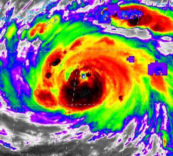
That's a.. really small eye on IR
2 likes
-
Shell Mound
- Category 5

- Posts: 2432
- Age: 33
- Joined: Thu Sep 07, 2017 3:39 pm
- Location: St. Petersburg, FL → Scandinavia
Re: ATL: IDA - Hurricane - Discussion
PavelGaborik wrote:Has recon found any winds to support an intensity of 105 MPH? I haven't seen anything near that yet.
She still has a ways to go.
It’s rather odd that the pressure has continued to decrease since the last pass, yet FL winds in the NE quadrant have not increased at all and still only support ~80 kt.
2 likes
CVW / MiamiensisWx / Shell Mound
The posts in this forum are NOT official forecasts and should not be used as such. They are just the opinion of the poster and may or may not be backed by sound meteorological data. They are NOT endorsed by any professional institution or STORM2K. For official information, please refer to products from the NHC and NWS.

Re: ATL: IDA - Hurricane - Discussion Update= NOAA plane found 965 mbs
And now it begins

5 likes
Very useful information on the Dvorak Technique --
https://severe.worldweather.wmo.int/TCF ... kBeven.pdf
https://severe.worldweather.wmo.int/TCF ... kBeven.pdf
-
ElectricStorm

- Category 5
- Posts: 5147
- Age: 25
- Joined: Tue Aug 13, 2019 11:23 pm
- Location: Norman, OK
Re: ATL: IDA - Hurricane - Discussion
Meteophile wrote:Structural issues caused by a bit of dry air at the beginning of the restructuration (dunno if this is an english word) may be a factor for a non-explosive intensification. Looks like there is 2 partial eyewalls that seem to be almost as strong as each other. The last time i saw 2 eyewalls having trouble to merge or to choose which one disappears was with typhoon haishen. That was probably not caused by the same factors, but the result was also a slower intensification.
(i'm probably writing something mainly wrong as i'm not even close to a meteorologist or an expert)
I get what your saying but usually when you have 2 concentric eyewalls, you'll see a spike in winds, then a dip, then another spike. That doesn't appear to be happening here, at least not yet. This one just seems like the broad wind field is making it a bit tougher to intensify rapidly than it would if it had a smaller core instead.
Sometimes the pressure will bomb, but the winds will wait until the pressure levels out to catch up. That's might be what's going on here. The winds are catching up slowly, but if the pressure begins to hold steady, the winds might catch up faster. But we'll see I'm no expert lol
Last edited by ElectricStorm on Sat Aug 28, 2021 8:03 pm, edited 1 time in total.
5 likes
B.S Meteorology, University of Oklahoma '25
Please refer to the NHC, NWS, or SPC for official information.
Please refer to the NHC, NWS, or SPC for official information.
Re: ATL: IDA - Hurricane - Discussion
Ida looks like a large and steadily strengthening hurricane with a beastly, even if smudgey appearance. we've seen quite a few of these in recent years. Michael had this appearance throughout much of its existence. In fact it tricked me into wrongly throwing shade at it more than once. I won't make that mistake again. No matter the ultimate landfall intensity, this storm is going to wreck things and kill people. The objective now is to minimize both. At this point I'd bet on persistence. Steady relentless intensification. A major hurricane landfall is likely...unknowable details yet to be resolved..
13 likes
-
cheezyWXguy

- Category 5
- Posts: 6282
- Joined: Mon Feb 13, 2006 12:29 am
- Location: Dallas, TX
Re: ATL: IDA - Hurricane - Discussion Update= NOAA plane found 965 mbs
grapealcoholic wrote:That's a.. really small eye on IR
You’re only seeing part of it, the southern half is obscured by the deeper convection.
5 likes
Re: ATL: IDA - Hurricane - Discussion Update= NOAA plane found 965 mbs
966 mb when corrected for sfc winds. with the closed eyewall structure this will really bomb out.
4 likes
Very useful information on the Dvorak Technique --
https://severe.worldweather.wmo.int/TCF ... kBeven.pdf
https://severe.worldweather.wmo.int/TCF ... kBeven.pdf
-
StormPyrate
- Category 1

- Posts: 286
- Joined: Sun May 27, 2018 8:41 pm
- Location: Clearwater, FL
Re: ATL: IDA - Hurricane - Discussion
I thought they had reported eye closed earlier
4 likes
St Petersburg Florida
-
nautical wheeler
- Tropical Low

- Posts: 28
- Joined: Mon Aug 27, 2012 2:13 pm
Re: ATL: IDA - Hurricane - Discussion
That’s impressive, and as far as I have been able to tell, this is the last box to check. If there isn’t a bump in intensity tonight, I will be at a loss for what the cause is.
It seems to me that the core got disrupted on the pass over the rise in elevation of Cuba and never recovered. It got really strong and consolidated after the pass over the Isle of Youth, hit the rise in elevation which caused a substantial updraft (the big blowup over the main island) and that updraft/subsidence continuously pulsated once it entered the gulf which provided the continuous energy. It created a wobbling spinning top effect, or like a gyroscope after you've applied a perpendicular force, it continues as long as the gyroscope maintains energy. Plausible? That's my amateur theory anyway.
2 likes
Re: ATL: IDA - Hurricane - Discussion
StormPyrate wrote:I thought they had reported eye closed earlier
Last VDM came through said "open to the south"
1 likes
Very useful information on the Dvorak Technique --
https://severe.worldweather.wmo.int/TCF ... kBeven.pdf
https://severe.worldweather.wmo.int/TCF ... kBeven.pdf
-
galaxy401

- Category 5
- Posts: 2446
- Age: 30
- Joined: Sat Aug 25, 2012 9:04 pm
- Location: Casa Grande, Arizona
Re: ATL: IDA - Hurricane - Discussion
As psyclone pointed out, recon has showed that Ida is a steadily strengthening storm. Probably been like that since the morning. Pressure is gradually dropping. Ida is having structural issues but it hasn't been weakening, just preventing it from RI at the moment.
The last pass showed a closed eyewall and Cat 2 winds for the first time. One can argue that Ida's delay in strengthening could actually be a bad thing since it could potentially bomb out right at landfall.
The last pass showed a closed eyewall and Cat 2 winds for the first time. One can argue that Ida's delay in strengthening could actually be a bad thing since it could potentially bomb out right at landfall.
4 likes
Got my eyes on moving right into Hurricane Alley: Florida.


Re: ATL: IDA - Hurricane - Discussion
Shell Mound wrote:PavelGaborik wrote:Has recon found any winds to support an intensity of 105 MPH? I haven't seen anything near that yet.
She still has a ways to go.
It’s rather odd that the pressure has continued to decrease since the last pass, yet FL winds in the NE quadrant have not increased at all and still only support ~80 kt.
This pass now supports 85 kt/966mb.
0 likes
Irene '11 Sandy '12 Hermine '16 5/15/2018 Derecho Fay '20 Isaias '20 Elsa '21 Henri '21 Ida '21
I am only a meteorology enthusiast who knows a decent amount about tropical cyclones. Look to the professional mets, the NHC, or your local weather office for the best information.
I am only a meteorology enthusiast who knows a decent amount about tropical cyclones. Look to the professional mets, the NHC, or your local weather office for the best information.
Re: ATL: IDA - Hurricane - Discussion
That's more like it

Last edited by Highteeld on Sat Aug 28, 2021 8:11 pm, edited 1 time in total.
1 likes
Very useful information on the Dvorak Technique --
https://severe.worldweather.wmo.int/TCF ... kBeven.pdf
https://severe.worldweather.wmo.int/TCF ... kBeven.pdf
Re: ATL: IDA - Hurricane - Discussion
jasons2k wrote:Good disco from New Orleans
https://uploads.tapatalk-cdn.com/20210829/e555f5cc2f0b3c06901ef44768b4608a.png
Best written plain English explanation I have yet read from Gov.
1 likes
-
CyclonicFury

- Category 5
- Posts: 2035
- Age: 27
- Joined: Sun Jul 02, 2017 12:32 pm
- Location: NC
- Contact:
Re: ATL: IDA - Hurricane - Discussion
This reminds me a lot of Harvey's intensification phase. Harvey's pressure steadily dropped about 2-3 mb an hour, but the winds remained 90-95 knots for a while. Eventually the winds caught up and Harvey quickly jumped from Cat 2 to Cat 4 in a few hours. I still think Ida has a good shot to reach Cat 4 before landfall if this deepening rate continues.
7 likes
NCSU B.S. in Meteorology Class of 2021. Tropical weather blogger at http://www.cyclonicfury.com. My forecasts and thoughts are NOT official, for official forecasts please consult the National Hurricane Center.
-
AlphaToOmega
- Category 5
- Posts: 1448
- Joined: Sat Jun 26, 2021 10:51 am
- Location: Somewhere in Massachusetts
Re: ATL: IDA - Hurricane - Discussion
It is going over very warm waters, and upper ocean heat content is still supportive of rapid intensification. With diurnal maximum approaching, Hurricane Ida will likely become a very powerful major hurricane.
1 likes
-
Dean4Storms
- S2K Supporter

- Posts: 6358
- Age: 63
- Joined: Sun Aug 31, 2003 1:01 pm
- Location: Miramar Bch. FL
Re: ATL: IDA - Hurricane - Discussion
Looks like Ida is starting to feel those warmer SST's in that loop current. Might see a quicker deepening overnight.
0 likes
-
Hypercane_Kyle

- Category 5
- Posts: 3465
- Joined: Sat Mar 07, 2015 7:58 pm
- Location: Cape Canaveral, FL
Re: ATL: IDA - Hurricane - Discussion
Highteeld wrote:StormPyrate wrote:I thought they had reported eye closed earlier
Last VDM came through said "open to the south"
Incorrect.
Code: Select all
D. Minimum Sea Level Pressure: 967mb (28.56 inHg)
E. Dropsonde Surface Wind at Center: From 130° at 10kts (From the SE at 12mph)
F. Eye Character: Closed
G. Eye Shape & Diameter: Circular with a diameter of 20 nautical miles (23 statute miles)
7 likes
My posts are my own personal opinion, defer to the National Hurricane Center (NHC) and other NOAA products for decision making during hurricane season.

Re: ATL: IDA - Hurricane - Discussion Update= NOAA plane found 965 mbs
The eye has been closed pretty much all day, the scariest part is the eye beginning to contract now.
0 likes
Who is online
Users browsing this forum: No registered users and 43 guests