ATL: SAM - Models

Moderator: S2k Moderators

Message
Author
User avatar
Spacecoast
Category 2
Category 2
Posts: 758
Joined: Thu Aug 31, 2017 2:03 pm

Re: ATL: INVEST 98L - Models

#301 Postby Spacecoast » Tue Sep 21, 2021 3:14 pm

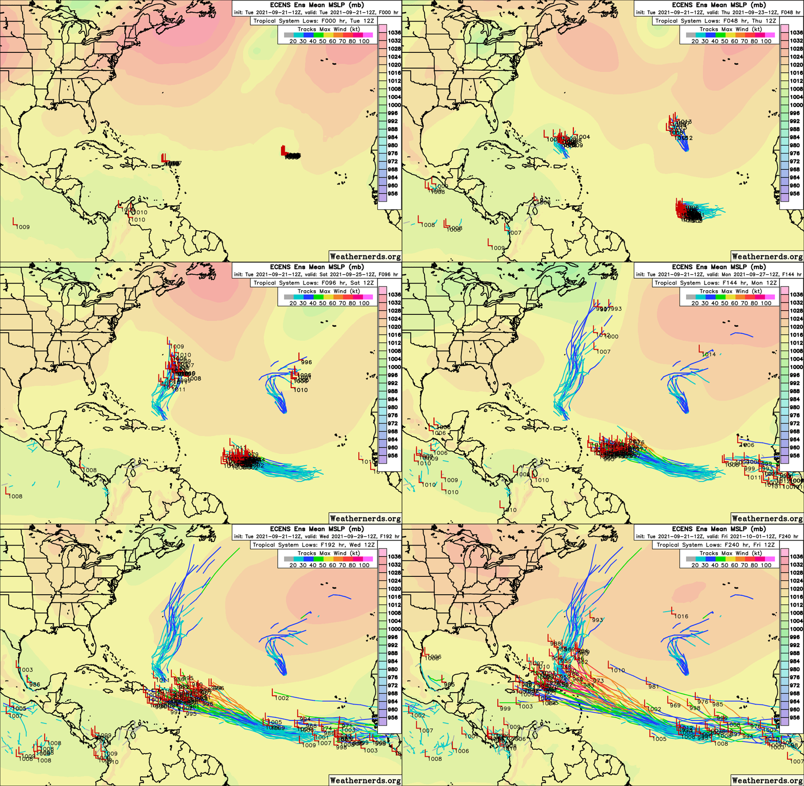
LarryWx wrote:12Z EPS: I count (at least) 4 hits on S or C FL (10/4-5) with also several different ones hitting further up in the SE US 10/5-6 meaning about 15% or so of the members hitting the SE US:

https://i.imgur.com/RMBv0Xo.png


Where is the mean (white) @ 330?
0 likes   

LarryWx
S2K Supporter
S2K Supporter
Posts: 6304
Joined: Sun Sep 07, 2003 2:04 pm
Location: GA

Re: ATL: INVEST 98L - Models

#302 Postby LarryWx » Tue Sep 21, 2021 3:16 pm

crownweather wrote:
LarryWx wrote:12Z EPS: I count (at least) 4 hits on S or C FL (10/4-5) with also several different ones hitting further up in the SE US 10/5-6 meaning about 15% or so of the members hitting the SE US:

https://i.imgur.com/RMBv0Xo.png


It looks like an overall increase in hits versus the 00Z EPS & certainly versus yesterday's 12Z EPS model run. Do you concur?


Yes. I had 3 SE US hits on each of the prior 2 runs and ~7-8 on this run including impending hits.
0 likes   
Personal Forecast Disclaimer:
The posts in this forum are NOT official forecasts and should not be used as such. They are just the opinion of the poster and may or may not be backed by sound meteorological data. They are NOT endorsed by any professional institution or storm2k.org. For official information, please refer to the NHC and NWS products.

AxaltaRacing24
Category 5
Category 5
Posts: 1753
Age: 25
Joined: Wed Jul 27, 2016 11:14 am
Location: Jupiter, FL

Re: ATL: INVEST 98L - Models

#303 Postby AxaltaRacing24 » Tue Sep 21, 2021 3:18 pm

LarryWx wrote:12Z EPS: I count (at least) 4 hits on S or C FL (10/4-5) with also several different ones hitting further up in the SE US 10/5-6 meaning about 15% or so of the members hitting the SE US:

https://i.imgur.com/RMBv0Xo.png

Part of me just wants to hope the calendar is right and not even worry about this coming anywhere near SFL, but my god these ensembles lol.
0 likes   

User avatar
InfernoFlameCat
Category 5
Category 5
Posts: 2102
Age: 22
Joined: Mon Dec 14, 2020 10:52 am
Location: Buford, GA

Re: ATL: INVEST 98L - Models

#304 Postby InfernoFlameCat » Tue Sep 21, 2021 3:18 pm

When the HWRF gets bullish, Eh. When the ECMWF gets bullish, :crazyeyes:
0 likes   
I am by no means a professional. DO NOT look at my forecasts for official information or make decisions based on what I post.

Goal: to become a registered expert over tropical and subtropical cyclones.

User avatar
SFLcane
S2K Supporter
S2K Supporter
Posts: 10163
Age: 47
Joined: Sat Jun 05, 2010 1:44 pm
Location: Lake Worth Florida

Re: ATL: INVEST 98L - Models

#305 Postby SFLcane » Tue Sep 21, 2021 3:24 pm

SouthFLTropics wrote:I think a good analogy for this storm could be 1999's Hurricane Floyd. It could get close enough to give us a few nervous moments here in South Florida but I find it highly unlikely that it makes it all the way to our shore. A recurve through the Bahama's with a swipe or landfall on the Outer Banks is what I'd be betting on right now. Not saying it can't or won't come to Florida, just that it is really hard to go against climatology in late September/early October. It is very difficult to get a hit from the east this far into the season. Now if this were to somehow make it into the Caribbean, I would definitely be more concerned. We have recent history with a few October storms out of the Caribbean (Wilma and Matthew, I'm looking at you).


Until that 1 day that SFL lucky streak comes to an abrupt end.
0 likes   

Fancy1001
Category 1
Category 1
Posts: 452
Joined: Thu Jul 16, 2020 10:16 pm

Re: ATL: INVEST 98L - Models

#306 Postby Fancy1001 » Tue Sep 21, 2021 3:25 pm

SFLcane wrote:
SouthFLTropics wrote:I think a good analogy for this storm could be 1999's Hurricane Floyd. It could get close enough to give us a few nervous moments here in South Florida but I find it highly unlikely that it makes it all the way to our shore. A recurve through the Bahama's with a swipe or landfall on the Outer Banks is what I'd be betting on right now. Not saying it can't or won't come to Florida, just that it is really hard to go against climatology in late September/early October. It is very difficult to get a hit from the east this far into the season. Now if this were to somehow make it into the Caribbean, I would definitely be more concerned. We have recent history with a few October storms out of the Caribbean (Wilma and Matthew, I'm looking at you).

I’ve been waiting for that day to come for so long.
Until that 1 day that SFL lucky streak comes to an abrupt end.
0 likes   

Fancy1001
Category 1
Category 1
Posts: 452
Joined: Thu Jul 16, 2020 10:16 pm

Re: ATL: INVEST 98L - Models

#307 Postby Fancy1001 » Tue Sep 21, 2021 3:26 pm

Fancy1001 wrote:
SFLcane wrote:
SouthFLTropics wrote:I think a good analogy for this storm could be 1999's Hurricane Floyd. It could get close enough to give us a few nervous moments here in South Florida but I find it highly unlikely that it makes it all the way to our shore. A recurve through the Bahama's with a swipe or landfall on the Outer Banks is what I'd be betting on right now. Not saying it can't or won't come to Florida, just that it is really hard to go against climatology in late September/early October. It is very difficult to get a hit from the east this far into the season. Now if this were to somehow make it into the Caribbean, I would definitely be more concerned. We have recent history with a few October storms out of the Caribbean (Wilma and Matthew, I'm looking at you).

I’ve been waiting for that day to come for so long.
Until that 1 day that SFL lucky streak comes to an abrupt end.

That was supposed to be in this section
0 likes   

User avatar
SFLcane
S2K Supporter
S2K Supporter
Posts: 10163
Age: 47
Joined: Sat Jun 05, 2010 1:44 pm
Location: Lake Worth Florida

Re: ATL: INVEST 98L - Models

#308 Postby SFLcane » Tue Sep 21, 2021 3:30 pm

Image
2 likes   

caneseddy
Category 5
Category 5
Posts: 1172
Joined: Fri Sep 03, 2004 9:31 pm
Location: Plantation, FL

Re: ATL: INVEST 98L - Models

#309 Postby caneseddy » Tue Sep 21, 2021 3:39 pm


The good news is that this is 10 days out which can and will change...however if it does not that pattern screams SE Florida

The posts in this forum are NOT official forecasts and should not be used as such. They are just the opinion of the poster and may or may not be backed by sound meteorological data. They are NOT endorsed by any professional institution or STORM2K. For official information, please refer to products from the NHC and NWS.
0 likes   

User avatar
skyline385
Category 5
Category 5
Posts: 2728
Age: 35
Joined: Wed Aug 26, 2020 11:15 pm
Location: Houston TX

ATL: INVEST 98L - Models

#310 Postby skyline385 » Tue Sep 21, 2021 3:42 pm

caneseddy wrote:


The good news is that this is 10 days out which can and will change...however if it does not that pattern screams SE Florida

The posts in this forum are NOT official forecasts and should not be used as such. They are just the opinion of the poster and may or may not be backed by sound meteorological data. They are NOT endorsed by any professional institution or STORM2K. For official information, please refer to products from the NHC and NWS.

Does it though? Very few systems actually hit SE FL while coming from near Cuba.
Last edited by skyline385 on Tue Sep 21, 2021 3:42 pm, edited 2 times in total.
0 likes   

AutoPenalti
Category 5
Category 5
Posts: 4030
Age: 29
Joined: Mon Aug 17, 2015 4:16 pm
Location: Ft. Lauderdale, Florida

Re: ATL: INVEST 98L - Models

#311 Postby AutoPenalti » Tue Sep 21, 2021 3:46 pm

caneseddy wrote:


The good news is that this is 10 days out which can and will change...however if it does not that pattern screams SE Florida

The posts in this forum are NOT official forecasts and should not be used as such. They are just the opinion of the poster and may or may not be backed by sound meteorological data. They are NOT endorsed by any professional institution or STORM2K. For official information, please refer to products from the NHC and NWS.

It doesn't. At the very end of the run most members sharply, and I mean SHARPLY curve it away from mainland US. If this run continued past 240 then I would bet on climo and say this is an uncomfortable OTS or Bermuda track for now.
0 likes   
The posts in this forum are NOT official forecasts and should not be used as such. They are just the opinion of the poster and may or may not be backed by sound meteorological data. They are NOT endorsed by any professional institution or STORM2K. For official information, please refer to products from the NHC and NWS.


Model Runs Cheat Sheet:
GFS (5:30 AM/PM, 11:30 AM/PM)
HWRF, GFDL, UKMET, NAVGEM (6:30-8:00 AM/PM, 12:30-2:00 AM/PM)
ECMWF (1:45 AM/PM)

TCVN
is a weighted averaged

Nuno
Category 2
Category 2
Posts: 597
Joined: Fri Aug 30, 2019 8:35 am
Location: Coral Gables, FL

Re: ATL: INVEST 98L - Models

#312 Postby Nuno » Tue Sep 21, 2021 3:49 pm

There's always a trough. Ensembles look at bit scary but its a long ways out and I trust the shield 8-)
1 likes   
Andrew (1992), Irene (1999), Frances (2004), Katrina (2005), Wilma (2005), Fay (2008), Irma (2017), Eta (2020), Ian (2022)

JPmia
S2K Supporter
S2K Supporter
Posts: 1070
Joined: Thu Jun 03, 2004 11:01 pm
Location: Fort Lauderdale, FL

Re: ATL: INVEST 98L - Models

#313 Postby JPmia » Tue Sep 21, 2021 3:56 pm

The parallel euro puts the hurricane further north of PR than the operational, which would imply a higher chance of an OTS solution. Anyone know the how much weight we should put into the new parallel euro vs. the operational euro?
0 likes   

User avatar
SFLcane
S2K Supporter
S2K Supporter
Posts: 10163
Age: 47
Joined: Sat Jun 05, 2010 1:44 pm
Location: Lake Worth Florida

ATL: INVEST 98L - Discussion

#314 Postby SFLcane » Tue Sep 21, 2021 4:01 pm

0 likes   

User avatar
Hypercane_Kyle
Category 5
Category 5
Posts: 3352
Joined: Sat Mar 07, 2015 7:58 pm
Location: Cape Canaveral, FL

Re: ATL: INVEST 98L - Models

#315 Postby Hypercane_Kyle » Tue Sep 21, 2021 4:01 pm

JPmia wrote:The parallel euro puts the hurricane further north of PR than the operational, which would imply a higher chance of an OTS solution. Anyone know the how much weight we should put into the new parallel euro vs. the operational euro?


Little, considering it's an experimental model.
0 likes   
My posts are my own personal opinion, defer to the National Hurricane Center (NHC) and other NOAA products for decision making during hurricane season.

grapealcoholic
Category 2
Category 2
Posts: 684
Joined: Tue Aug 10, 2021 3:26 pm

Re: ATL: INVEST 98L - Models

#316 Postby grapealcoholic » Tue Sep 21, 2021 4:04 pm

Hypercane_Kyle wrote:
JPmia wrote:The parallel euro puts the hurricane further north of PR than the operational, which would imply a higher chance of an OTS solution. Anyone know the how much weight we should put into the new parallel euro vs. the operational euro?


Little, considering it's an experimental model.

I wouldn't say experimental. It's going into operation next month
0 likes   

User avatar
crownweather
S2K Supporter
S2K Supporter
Posts: 595
Age: 50
Joined: Sat Aug 12, 2006 9:21 am
Location: Sturbridge, Massachusetts
Contact:

Re: ATL: INVEST 98L - Models

#317 Postby crownweather » Tue Sep 21, 2021 4:05 pm

JPmia wrote:The parallel euro puts the hurricane further north of PR than the operational, which would imply a higher chance of an OTS solution. Anyone know the how much weight we should put into the new parallel euro vs. the operational euro?


Just FYI - The 12Z parallel Euro model has shifted further SW with its forecast track of 98L as compared to the 00Z run. It now brings this system right across the northern Leewards and very near, if not right over the Virgin Islands. Last night's 00Z parallel Euro run missed all of these islands to the north.
4 likes   
Rob Lightbown
Crown Weather Services
https://crownweather.com

tolakram
Admin
Admin
Posts: 20009
Age: 62
Joined: Sun Aug 27, 2006 8:23 pm
Location: Florence, KY (name is Mark)

Re: ATL: INVEST 98L - Models

#318 Postby tolakram » Tue Sep 21, 2021 4:14 pm

Here's 250mb with the latest euro, a completely different look.

Image

Image
0 likes   
M a r k
- - - - -
Join us in chat: Storm2K Chatroom Invite. Android and IOS apps also available.

The posts in this forum are NOT official forecasts and should not be used as such. Posts are NOT endorsed by any professional institution or STORM2K.org. For official information and forecasts, please refer to NHC and NWS products.

JPmia
S2K Supporter
S2K Supporter
Posts: 1070
Joined: Thu Jun 03, 2004 11:01 pm
Location: Fort Lauderdale, FL

Re: ATL: INVEST 98L - Models

#319 Postby JPmia » Tue Sep 21, 2021 4:19 pm

crownweather wrote:
JPmia wrote:The parallel euro puts the hurricane further north of PR than the operational, which would imply a higher chance of an OTS solution. Anyone know the how much weight we should put into the new parallel euro vs. the operational euro?


Just FYI - The 12Z parallel Euro model has shifted further SW with its forecast track of 98L as compared to the 00Z run. It now brings this system right across the northern Leewards and very near, if not right over the Virgin Islands. Last night's 00Z parallel Euro run missed all of these islands to the north.


You're right and then turns it north from the Leewards where as the operational continues it west. I'm just wondering how much stock to put into this new version.. is it ready for prime time.
0 likes   

grapealcoholic
Category 2
Category 2
Posts: 684
Joined: Tue Aug 10, 2021 3:26 pm

Re: ATL: INVEST 98L - Models

#320 Postby grapealcoholic » Tue Sep 21, 2021 4:23 pm

Can someone post the parallel euro 12z run?
0 likes   


Return to “2021”

Who is online

Users browsing this forum: No registered users and 5 guests