The closest they've been in two days.
ATL: ELSA - Post-Tropical - Discussion
Moderator: S2k Moderators
-
BYG Jacob
-
eastcoastFL

- Category 5

- Posts: 3996
- Age: 44
- Joined: Thu Apr 12, 2007 12:29 pm
- Location: Palm City, FL
Re: ATL: ELSA - Tropical Storm - Discussion
Some outer bands starting to show on SFWMD radar. Interesting watching them coming E to W while the storms from the front over Florida head the opposite direction.

7 likes
Personal Forecast Disclaimer:
The posts in this forum are NOT official forecast and should not be used as such. They are just the opinion of the poster and may or may not be backed by sound meteorological data. They are NOT endorsed by any professional institution or storm2k.org. For official information, please refer to the NHC and NWS products.
The posts in this forum are NOT official forecast and should not be used as such. They are just the opinion of the poster and may or may not be backed by sound meteorological data. They are NOT endorsed by any professional institution or storm2k.org. For official information, please refer to the NHC and NWS products.
-
eastcoastFL
- Category 5
- Posts: 3996
- Age: 44
- Joined: Thu Apr 12, 2007 12:29 pm
- Location: Palm City, FL
Re: ATL: ELSA - Tropical Storm - Discussion
So she’s apparently doing a little better than she was last night


1 likes
Personal Forecast Disclaimer:
The posts in this forum are NOT official forecast and should not be used as such. They are just the opinion of the poster and may or may not be backed by sound meteorological data. They are NOT endorsed by any professional institution or storm2k.org. For official information, please refer to the NHC and NWS products.
The posts in this forum are NOT official forecast and should not be used as such. They are just the opinion of the poster and may or may not be backed by sound meteorological data. They are NOT endorsed by any professional institution or storm2k.org. For official information, please refer to the NHC and NWS products.
-
eastcoastFL
- Category 5
- Posts: 3996
- Age: 44
- Joined: Thu Apr 12, 2007 12:29 pm
- Location: Palm City, FL
Re: ATL: ELSA - Tropical Storm - Discussion
NWS Melbourne
Tropical update...As of 930 pm, there has been no big changes in
the forecast regarding Elsa and its possible impacts to east
central FL. We continue to advertise periods of heavy rainfall, a
few tornadoes, and gusty winds across the local area on Tuesday
into Wednesday morning as the storm moves parallel to the west
coast then to our north. No watches or warnings are in effect for
any of the east central FL counties but continue to monitor our
updates in case any of these is necessary as the storm gets
closer to our area.
2 likes
Personal Forecast Disclaimer:
The posts in this forum are NOT official forecast and should not be used as such. They are just the opinion of the poster and may or may not be backed by sound meteorological data. They are NOT endorsed by any professional institution or storm2k.org. For official information, please refer to the NHC and NWS products.
The posts in this forum are NOT official forecast and should not be used as such. They are just the opinion of the poster and may or may not be backed by sound meteorological data. They are NOT endorsed by any professional institution or storm2k.org. For official information, please refer to the NHC and NWS products.

Re: ATL: ELSA - Tropical Storm - Discussion
Jr0d wrote:Unflagged 64kt SFMR in the latest pass...getting close to H status..pressure has to go below 1000mb. Likely not enough to upgrade, but can see the NHC going with 65 or 70mph next advisory.b
If there's enough data to support it I don't think the pressure would necessarily have to drop below a threshold--Bob in 1985 (also fairly small) was 1002mb as a hurricane.
6 likes
The above post is not official and should not be used as such. It is the opinion of the poster and may or may not be backed by sound meteorological data. It is not endorsed by any professional institution or storm2k.org. For official information, please refer to the NHC and NWS products.
-
gatorcane

- S2K Supporter

- Posts: 23708
- Age: 48
- Joined: Sun Mar 13, 2005 3:54 pm
- Location: Boca Raton, FL
Re: ATL: ELSA - Tropical Storm - Discussion
Impressive upper anticyclone over Elsa with clockwise flow fanning the clouds on all sides:
10 likes
-
jlauderdal
- S2K Supporter
- Posts: 7240
- Joined: Wed May 19, 2004 5:46 am
- Location: NE Fort Lauderdale
- Contact:
Re: ATL: ELSA - Tropical Storm - Discussion
Last edited by tolakram on Sun Jul 04, 2021 9:50 pm, edited 1 time in total.
Reason: added tweet tags
Reason: added tweet tags
1 likes
-
Hypercane_Kyle

- Category 5
- Posts: 3465
- Joined: Sat Mar 07, 2015 7:58 pm
- Location: Cape Canaveral, FL
Re: ATL: ELSA - Tropical Storm - Discussion
Hammy wrote:Jr0d wrote:Unflagged 64kt SFMR in the latest pass...getting close to H status..pressure has to go below 1000mb. Likely not enough to upgrade, but can see the NHC going with 65 or 70mph next advisory.b
If there's enough data to support it I don't think the pressure would necessarily have to drop below a threshold--Bob in 1985 (also fairly small) was 1002mb as a hurricane.
IIRC SFMR is high-biased in shallow waters. The 64 knot SFMR is likely inaccurate.
1 likes
My posts are my own personal opinion, defer to the National Hurricane Center (NHC) and other NOAA products for decision making during hurricane season.
-
ColdMiser123

- Professional-Met

- Posts: 905
- Age: 29
- Joined: Mon Sep 26, 2016 3:26 pm
- Location: Northeast US
Re: ATL: ELSA - Tropical Storm - Discussion
Hypercane_Kyle wrote:Hammy wrote:Jr0d wrote:Unflagged 64kt SFMR in the latest pass...getting close to H status..pressure has to go below 1000mb. Likely not enough to upgrade, but can see the NHC going with 65 or 70mph next advisory.b
If there's enough data to support it I don't think the pressure would necessarily have to drop below a threshold--Bob in 1985 (also fairly small) was 1002mb as a hurricane.
IIRC SFMR is high-biased in shallow waters. The 64 knot SFMR is likely inaccurate.
You would likely expect to see FL wind at around 71 kt if the 64 kt SFMR is genuine, peak FL wind measured so far has been well short of that. So I doubt they base any kind of upgrade based on SFMR alone.
5 likes
B.S., M.S., Meteorology & Atmospheric Science
Re: ATL: ELSA - Tropical Storm - Discussion
Is there something going on with the plane's barometer? The readings are getting farther and farther from what the VDMs are saying.
0 likes
The above post is not official and should not be used as such. It is the opinion of the poster and may or may not be backed by sound meteorological data. It is not endorsed by any professional institution or storm2k.org. For official information, please refer to the NHC and NWS products.

Re: ATL: ELSA - Tropical Storm - Discussion
Looks like good news for Tampa Bay to Big Bend area.
CAPE and TPW infeed is forecast to be minimal with little to no UL support.
CAPE and TPW infeed is forecast to be minimal with little to no UL support.
3 likes
-
SFLcane

- S2K Supporter
- Posts: 10281
- Age: 48
- Joined: Sat Jun 05, 2010 1:44 pm
- Location: Lake Worth Florida
-
MarioProtVI
- Category 5
- Posts: 1034
- Age: 24
- Joined: Sun Sep 29, 2019 7:33 pm
- Location: New Jersey
Re: ATL: ELSA - Tropical Storm - Discussion
Hammy wrote:Is there something going on with the plane's barometer? The readings are getting farther and farther from what the VDMs are saying.
It’s the same plane that showed weird readings yesterday and when Elsa first became a hurricane. It’s really weird
3 likes
-
jlauderdal
- S2K Supporter
- Posts: 7240
- Joined: Wed May 19, 2004 5:46 am
- Location: NE Fort Lauderdale
- Contact:
Re: RE: Re: ATL: ELSA - Tropical Storm - Discussion
Will be interesting how Elsa's turn to the NE takes place. Steering winds right now show after Cuba, direction favors NE. Models all agree NE motion won't start until it passes at least north of Ft Myers. All of Fla west coast should be alert, not just center of track. https://t.co/SJ10PC8Y4ZSFLcane wrote:
What’s he saying I can’t see his tweet?
1 likes
-
SFLcane
- S2K Supporter
- Posts: 10281
- Age: 48
- Joined: Sat Jun 05, 2010 1:44 pm
- Location: Lake Worth Florida
Re: RE: Re: ATL: ELSA - Tropical Storm - Discussion
jlauderdal wrote:Will be interesting how Elsa's turn to the NE takes place. Steering winds right now show after Cuba, direction favors NE. Models all agree NE motion won't start until it passes at least north of Ft Myers. All of Fla west coast should be alert, not just center of track. https://t.co/SJ10PC8Y4ZSFLcane wrote:
What’s he saying I can’t see his tweet?
Turn could be sooner. We have to wait and see we’re it exits the Cuban coast.
0 likes
Re: ATL: ELSA - Tropical Storm - Discussion
11:00 PM EDT Sun Jul 4
Location: 20.6°N 79.2°W
Moving: NW at 15 mph
Min pressure: 1004 mb
Max sustained: 65 mph
The initial motion estimate is 310/13 kt. There remains no
significant change to the previous few track forecasts and synoptic
reasonings. Elsa is expected to move northwestward and then
northward around the western periphery of a mid-level subtropical
ridge during the next 3 days, followed by acceleration toward the
northeast on days 4 and 5 as the cyclone moves near the southeast
U.S. coast and then over the northwestern Atlantic. The new NHC
track forecast is basically just an update and extension of the
previous advisory track, and lies close to a blend of the tightly
packed corrected consensus model HCCA and the simple consensus
models TVCA and GFEX.
Cuban radar data from Pilan and Camaguey have occasionally revealed
an eye-like feature in the low -and mid-levels of the cyclone where
cloud top temperatures have been colder than -80C and also where
significant lightning activity has been occurring. Given that the
circulation centers have become better aligned and the upper-level
outflow pattern is well-established and steadily improving, some
additional strengthening during the next 12 h is forecast, which
calls for Elsa to be near hurricane strength before landfall occurs
along the south-central coast of Cuba tomorrow. Over the eastern
Gulf of Mexico late Monday and Tuesday, some restrengthening is
forecast after Elsa clears Cuba, but southwesterly vertical wind
shear is expected to hinder the intensification process. The
official intensity forecast remains on the high side of the
numerical model guidance, and follows a blend of the HCCA intensity
consensus model, and the LGEM and and Decay-SHIPS
statistical-dynamical models.
Key Messages:
1. Widespread heavy rain will continue to affect portions of Jamaica
tonight where isolated to scattered flash flooding and mudslides
will be possible. Heavy rain will then impact the Cayman Islands and
Cuba tonight into Monday resulting in significant flooding and
mudslides over Cuba. As Elsa approaches the Florida Keys, Florida
Peninsula, and coastal Georgia Monday through Wednesday, heavy
rainfall may result in isolated flash, urban, and minor river
flooding. Mid to late week, heavy rains across coastal South
Carolina may result in isolated flash flooding.
2. Tropical storm conditions and a dangerous storm surge are
expected with hurricane conditions possible in portions of eastern
Cuba tonight. Tropical storm conditions are expected in portions
of central and western Cuba tonight and Monday, and will spread
into portions of the Florida Keys by late Monday.
3. Tropical Storm and Surge Surge Watches are in effect for
portions of the west coast of the Florida peninsula where tropical
storm conditions and a dangerous storm surge are possible beginning
as early as Monday night and continuing into Tuesday.
4. There is a risk of tropical storm conditions, storm surge,
and rainfall impacts along the remainder of the Florida Peninsula
Tuesday night through Wednesday and the coasts of Georgia and the
Carolinas Wednesday and Thursday.
FORECAST POSITIONS AND MAX WINDS
INIT 05/0300Z 20.6N 79.2W 55 KT 65 MPH
12H 05/1200Z 21.9N 80.7W 60 KT 70 MPH
24H 06/0000Z 23.5N 82.1W 50 KT 60 MPH
36H 06/1200Z 25.1N 82.9W 50 KT 60 MPH
48H 07/0000Z 27.1N 83.2W 50 KT 60 MPH
60H 07/1200Z 29.2N 82.8W 45 KT 50 MPH...INLAND
72H 08/0000Z 31.5N 81.6W 35 KT 40 MPH...INLAND
96H 09/0000Z 36.0N 76.0W 35 KT 40 MPH...INLAND
120H 10/0000Z 41.0N 66.8W 40 KT 45 MPH...OVER WATER
$$
Forecaster Stewart
1 likes
-
ScottNAtlanta

- Category 5
- Posts: 2535
- Joined: Sat May 25, 2013 3:11 pm
- Location: Atlanta, GA
Re: ATL: ELSA - Tropical Storm - Discussion
Neither the MLC to the south or the LLC that the NHC is tracking will give in to the other. As long as they are competing this isn't going to do much in the way of strengthening.
6 likes
The posts in this forum are NOT official forecast and should not be used as such. They are just the opinion of the poster and may or may not be backed by sound meteorological data. They are NOT endorsed by any professional institution or storm2k.org. For official information, please refer to the NHC and NWS products.
-
AutoPenalti
- Category 5
- Posts: 4091
- Age: 29
- Joined: Mon Aug 17, 2015 4:16 pm
- Location: Ft. Lauderdale, Florida
Re: ATL: ELSA - Tropical Storm - Discussion
Yeah, this was an issue in the beginning. It’s become a battle of vortices that seems to have no ending in sight.
1 likes
The posts in this forum are NOT official forecasts and should not be used as such. They are just the opinion of the poster and may or may not be backed by sound meteorological data. They are NOT endorsed by any professional institution or STORM2K. For official information, please refer to products from the NHC and NWS.
Model Runs Cheat Sheet:
GFS (5:30 AM/PM, 11:30 AM/PM)
HWRF, GFDL, UKMET, NAVGEM (6:30-8:00 AM/PM, 12:30-2:00 AM/PM)
ECMWF (1:45 AM/PM)
TCVN is a weighted averaged
-
Category5Kaiju

- Category 5
- Posts: 4336
- Joined: Thu Dec 24, 2020 12:45 pm
- Location: Seattle during the summer, Phoenix during the winter
Re: ATL: ELSA - Tropical Storm - Discussion
Yeah at this point I am inclined to say that Elsa seems to be one of those storms that simply struggle throughout its existence. When one issue is resolved, another issue appears, and then when that issue is resolved, another issue appears. I am not sure if climo has something to do with this or if it is simply bad luck with shear or what not, but one thing I am somewhat confident to say is this: had Elsa been going a lot slower from the beginning, we could have been looking at a monster major hurricane by now, and a lot of problems she is currently suffering from would not have been really big problems. Fortunately that did not come to fruition, but the fact that we got Elsa in the first place attain hurricane status in the MDR in extreme early July really begs the question of what is to come not only later the season but even toward the end of this month.
9 likes
Unless explicitly stated, all information in my posts is based on my own opinions and observations. Tropical storms and hurricanes can be extremely dangerous. Refer to an accredited weather research agency or meteorologist if you need to make serious decisions regarding an approaching storm.
-
skyline385

- Category 5
- Posts: 2728
- Age: 35
- Joined: Wed Aug 26, 2020 11:15 pm
- Location: Houston TX
Re: ATL: ELSA - Tropical Storm - Discussion
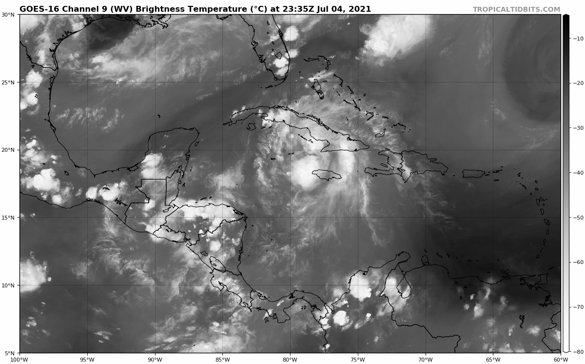
Just saw the latest IR, what is this shape even? Can't remember the last storm i saw which looked as ugly as this...
0 likes
Who is online
Users browsing this forum: No registered users and 25 guests