ATL: ELSA - Models

Moderator: S2k Moderators

Message
Author
AutoPenalti
Category 5
Category 5
Posts: 4030
Age: 29
Joined: Mon Aug 17, 2015 4:16 pm
Location: Ft. Lauderdale, Florida

Re: ATL: ELSA - Models

#541 Postby AutoPenalti » Fri Jul 02, 2021 11:24 am

fox13weather wrote:
AutoPenalti wrote:
fox13weather wrote:
What if it turns out to be more accurate than the GFS? Is it impossible for the Euro solution to come close to verifying?

Well for starters, it didn't get initialization right for the past 3 days...


So? It doesn't mean that it's solution will turn out wrong. If Elsa ends up much weaker and east of Florida, it will be the more accurate than the GFS. I will admit that it's forecast looks suspect, but it in two days it's not impossible that we are saying that the euro was on to something all along....

We'll see.
1 likes   
The posts in this forum are NOT official forecasts and should not be used as such. They are just the opinion of the poster and may or may not be backed by sound meteorological data. They are NOT endorsed by any professional institution or STORM2K. For official information, please refer to products from the NHC and NWS.


Model Runs Cheat Sheet:
GFS (5:30 AM/PM, 11:30 AM/PM)
HWRF, GFDL, UKMET, NAVGEM (6:30-8:00 AM/PM, 12:30-2:00 AM/PM)
ECMWF (1:45 AM/PM)

TCVN
is a weighted averaged

Hurricane Mike
Category 2
Category 2
Posts: 644
Joined: Tue Apr 10, 2018 7:44 am

Re: ATL: ELSA - Models

#542 Postby Hurricane Mike » Fri Jul 02, 2021 11:26 am

Once again the EURO showed almost no genesis and certainly not a hurricane.
0 likes   

User avatar
Weatherboy1
Category 5
Category 5
Posts: 1189
Age: 49
Joined: Mon Jul 05, 2004 1:50 pm
Location: Jupiter/Sarasota, FL

Re: ATL: ELSA - Models

#543 Postby Weatherboy1 » Fri Jul 02, 2021 11:27 am

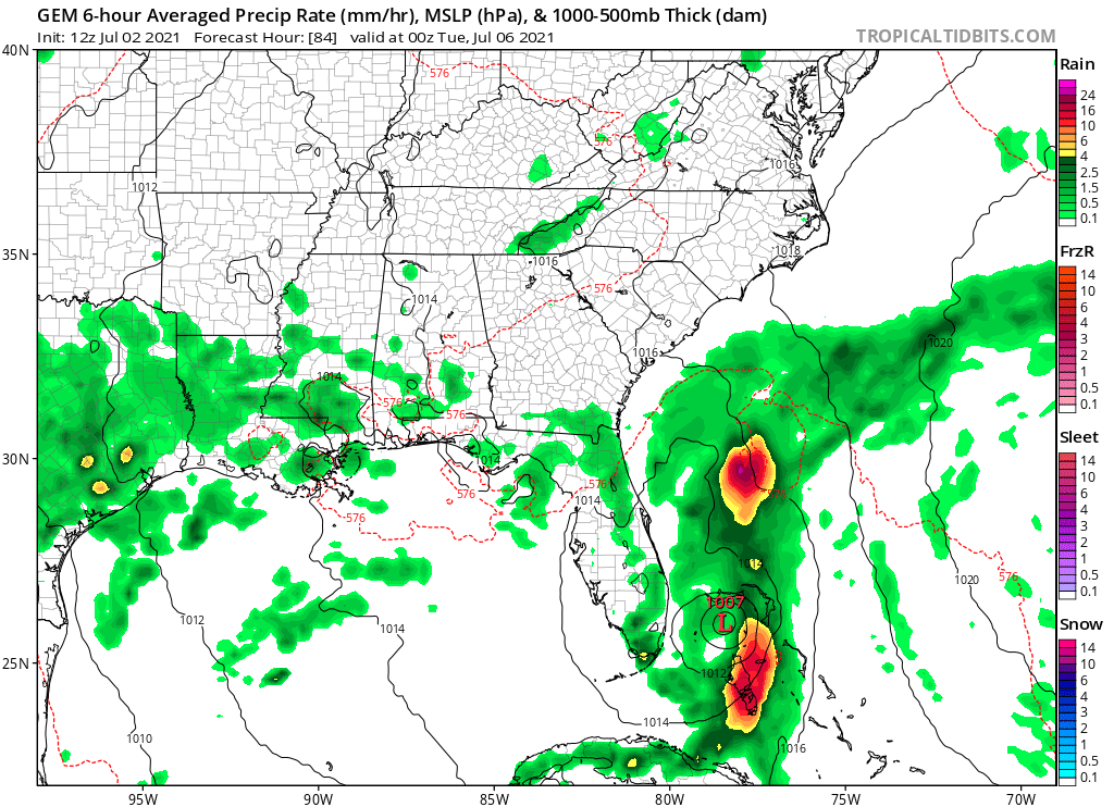
So looks like GFS has shifted back W in the long term. UKMET has stopped forecasting a move toward the Yucatan and joined the WNW/NW/N/NE turn (though still out in the Gulf vs. over Florida peninsula). CMC still sending a weaker Elsa just to the E of FL
Last edited by Weatherboy1 on Fri Jul 02, 2021 11:54 am, edited 2 times in total.
0 likes   

User avatar
tiger_deF
Category 1
Category 1
Posts: 468
Age: 24
Joined: Tue Sep 27, 2016 11:47 am

Re: ATL: ELSA - Models

#544 Postby tiger_deF » Fri Jul 02, 2021 11:36 am

Weatherboy1 wrote:So looks like GFS has shifted back W in the long term. UKMET has stopped forecasting a move toward the Yucatan and joined the WNW/NW/N/NE turn (though still out in the Gulf vs. over Florida peninsula). CMC still sending a much weaker Elsa in general direction of Southeast FL


Frankly, just going off the models you'd think Elsa was a middling tropical storm. Surprised by the recent shifts
2 likes   

User avatar
eastcoastFL
Category 5
Category 5
Posts: 3901
Age: 43
Joined: Thu Apr 12, 2007 12:29 pm
Location: Palm City, FL

Re: ATL: ELSA - Models

#545 Postby eastcoastFL » Fri Jul 02, 2021 11:38 am

fox13weather wrote:
eastcoastFL wrote:
NDG wrote:For those of you still following the Euro its latest 06z run has Elsa opening up into the TW tonight, lol.

https://i.imgur.com/EASagi4.png


I really hope the people that run the euro are doing some heavy upgrades and fast.


What if it turns out to be more accurate than the GFS? Is it impossible for the Euro solution to come close to verifying?


It could turn out to be accurate down the road but that won’t discount how miserably it’s failed with the system so far. It’s also repeating the same failures as last year with storms like Laura so it clearly has some issues to work out.
Last edited by eastcoastFL on Fri Jul 02, 2021 11:46 am, edited 1 time in total.
2 likes   
Personal Forecast Disclaimer:
The posts in this forum are NOT official forecast and should not be used as such. They are just the opinion of the poster and may or may not be backed by sound meteorological data. They are NOT endorsed by any professional institution or storm2k.org. For official information, please refer to the NHC and NWS products.

User avatar
gatorcane
S2K Supporter
S2K Supporter
Posts: 23691
Age: 47
Joined: Sun Mar 13, 2005 3:54 pm
Location: Boca Raton, FL

Re: ATL: ELSA - Models

#546 Postby gatorcane » Fri Jul 02, 2021 11:40 am

CMC is weaker and has shifted more east of Florida:

Image
1 likes   

hurricane2025
Tropical Storm
Tropical Storm
Posts: 208
Joined: Thu Apr 08, 2021 10:36 am

Re: ATL: ELSA - Models

#547 Postby hurricane2025 » Fri Jul 02, 2021 11:42 am

Never trust models till about 3 days out , also hard to get a strong system this early but if this was august or sept man oh man
0 likes   

User avatar
Hypercane_Kyle
Category 5
Category 5
Posts: 3352
Joined: Sat Mar 07, 2015 7:58 pm
Location: Cape Canaveral, FL

Re: ATL: ELSA - Models

#548 Postby Hypercane_Kyle » Fri Jul 02, 2021 11:53 am

12z HWRF initialization spot-on.
4 likes   
My posts are my own personal opinion, defer to the National Hurricane Center (NHC) and other NOAA products for decision making during hurricane season.

tolakram
Admin
Admin
Posts: 20009
Age: 62
Joined: Sun Aug 27, 2006 8:23 pm
Location: Florence, KY (name is Mark)

Re: ATL: ELSA - Models

#549 Postby tolakram » Fri Jul 02, 2021 12:04 pm

Image

A little stronger, further south. Always nice to have model agreement. :grr:
0 likes   
M a r k
- - - - -
Join us in chat: Storm2K Chatroom Invite. Android and IOS apps also available.

The posts in this forum are NOT official forecasts and should not be used as such. Posts are NOT endorsed by any professional institution or STORM2K.org. For official information and forecasts, please refer to NHC and NWS products.

User avatar
eastcoastFL
Category 5
Category 5
Posts: 3901
Age: 43
Joined: Thu Apr 12, 2007 12:29 pm
Location: Palm City, FL

Re: ATL: ELSA - Models

#550 Postby eastcoastFL » Fri Jul 02, 2021 12:07 pm

Gonna miss Hispaniola

Image
0 likes   
Personal Forecast Disclaimer:
The posts in this forum are NOT official forecast and should not be used as such. They are just the opinion of the poster and may or may not be backed by sound meteorological data. They are NOT endorsed by any professional institution or storm2k.org. For official information, please refer to the NHC and NWS products.

User avatar
eastcoastFL
Category 5
Category 5
Posts: 3901
Age: 43
Joined: Thu Apr 12, 2007 12:29 pm
Location: Palm City, FL

Re: ATL: ELSA - Models

#551 Postby eastcoastFL » Fri Jul 02, 2021 12:13 pm

Yup threads the needle south of DR….

Image
0 likes   
Personal Forecast Disclaimer:
The posts in this forum are NOT official forecast and should not be used as such. They are just the opinion of the poster and may or may not be backed by sound meteorological data. They are NOT endorsed by any professional institution or storm2k.org. For official information, please refer to the NHC and NWS products.

Cat5James
Category 1
Category 1
Posts: 417
Joined: Fri Sep 06, 2019 7:54 pm

Re: ATL: ELSA - Models

#552 Postby Cat5James » Fri Jul 02, 2021 12:15 pm

These systems love to avoid interaction with land when possible. Multiple times I've seen the center of a storm dance around an island it looked sure to be on a collision course with. Threading the needle as models have consistantly shown over the past week definitely seems plausible.
3 likes   

User avatar
Jr0d
S2K Supporter
S2K Supporter
Posts: 1409
Joined: Tue Aug 27, 2019 10:52 am
Location: Cayo Hueso

Re: ATL: ELSA - Models

#553 Postby Jr0d » Fri Jul 02, 2021 12:16 pm

Looking at the IR simulation, the GFS is very poorly inialized showing a disorganized storm/borderline open wave. Hopefully the next run will be more realistic.

The HWRF looks like a great initialization but I'm always skeptical of how it can often be overly bullish.....but so far seems to be performing great.
2 likes   

AutoPenalti
Category 5
Category 5
Posts: 4030
Age: 29
Joined: Mon Aug 17, 2015 4:16 pm
Location: Ft. Lauderdale, Florida

Re: ATL: ELSA - Models

#554 Postby AutoPenalti » Fri Jul 02, 2021 12:17 pm

Cat5James wrote:These systems love to avoid interaction with land when possible. Multiple times I've seen the center of a storm dance around an island it looked sure to be on a collision course with. Threading the needle as models have consistantly shown over the past week definitely seems plausible.

Dorian came to mind. Most models had it disappearing near the islands, threaded the needle, and the rest is history.
2 likes   
The posts in this forum are NOT official forecasts and should not be used as such. They are just the opinion of the poster and may or may not be backed by sound meteorological data. They are NOT endorsed by any professional institution or STORM2K. For official information, please refer to products from the NHC and NWS.


Model Runs Cheat Sheet:
GFS (5:30 AM/PM, 11:30 AM/PM)
HWRF, GFDL, UKMET, NAVGEM (6:30-8:00 AM/PM, 12:30-2:00 AM/PM)
ECMWF (1:45 AM/PM)

TCVN
is a weighted averaged

AutoPenalti
Category 5
Category 5
Posts: 4030
Age: 29
Joined: Mon Aug 17, 2015 4:16 pm
Location: Ft. Lauderdale, Florida

Re: ATL: ELSA - Models

#555 Postby AutoPenalti » Fri Jul 02, 2021 12:19 pm

FWIW it's 2mb weaker.

Image
0 likes   
The posts in this forum are NOT official forecasts and should not be used as such. They are just the opinion of the poster and may or may not be backed by sound meteorological data. They are NOT endorsed by any professional institution or STORM2K. For official information, please refer to products from the NHC and NWS.


Model Runs Cheat Sheet:
GFS (5:30 AM/PM, 11:30 AM/PM)
HWRF, GFDL, UKMET, NAVGEM (6:30-8:00 AM/PM, 12:30-2:00 AM/PM)
ECMWF (1:45 AM/PM)

TCVN
is a weighted averaged

User avatar
eastcoastFL
Category 5
Category 5
Posts: 3901
Age: 43
Joined: Thu Apr 12, 2007 12:29 pm
Location: Palm City, FL

Re: ATL: ELSA - Models

#556 Postby eastcoastFL » Fri Jul 02, 2021 12:20 pm

Jr0d wrote:Looking at the IR simulation, the GFS is very poorly inialized showing a disorganized storm/borderline open wave. Hopefully the next run will be more realistic.

The HWRF looks like a great initialization but I'm always skeptical of how it can often be overly bullish.....but so far seems to be performing great.


It’s showing some slight weakening as it crosses the islands today but then ramps back up overnight when it gets south of DR.
0 likes   
Personal Forecast Disclaimer:
The posts in this forum are NOT official forecast and should not be used as such. They are just the opinion of the poster and may or may not be backed by sound meteorological data. They are NOT endorsed by any professional institution or storm2k.org. For official information, please refer to the NHC and NWS products.

tolakram
Admin
Admin
Posts: 20009
Age: 62
Joined: Sun Aug 27, 2006 8:23 pm
Location: Florence, KY (name is Mark)

Re: ATL: ELSA - Models

#557 Postby tolakram » Fri Jul 02, 2021 12:21 pm

Next frame is stronger though. Looks about the same overall.

Image
1 likes   
M a r k
- - - - -
Join us in chat: Storm2K Chatroom Invite. Android and IOS apps also available.

The posts in this forum are NOT official forecasts and should not be used as such. Posts are NOT endorsed by any professional institution or STORM2K.org. For official information and forecasts, please refer to NHC and NWS products.

AutoPenalti
Category 5
Category 5
Posts: 4030
Age: 29
Joined: Mon Aug 17, 2015 4:16 pm
Location: Ft. Lauderdale, Florida

Re: ATL: ELSA - Models

#558 Postby AutoPenalti » Fri Jul 02, 2021 12:23 pm

I'm blind, is that 985 or 965?
0 likes   
The posts in this forum are NOT official forecasts and should not be used as such. They are just the opinion of the poster and may or may not be backed by sound meteorological data. They are NOT endorsed by any professional institution or STORM2K. For official information, please refer to products from the NHC and NWS.


Model Runs Cheat Sheet:
GFS (5:30 AM/PM, 11:30 AM/PM)
HWRF, GFDL, UKMET, NAVGEM (6:30-8:00 AM/PM, 12:30-2:00 AM/PM)
ECMWF (1:45 AM/PM)

TCVN
is a weighted averaged

User avatar
robbielyn
Category 5
Category 5
Posts: 1298
Joined: Wed May 07, 2003 9:45 am
Location: brooksville, fl

Re: ATL: ELSA - Models

#559 Postby robbielyn » Fri Jul 02, 2021 12:23 pm

1004 mb into wakulla in the panhandle just east of appalach for landfall. i can live with that if it pans out.
3 likes   
Robbielyn McCrary
I know just about enough to sound like I know what I'm talking about sometimes. But for your safety please follow the nhc for truly professional forecasting. :D

User avatar
galaxy401
Category 5
Category 5
Posts: 2419
Age: 30
Joined: Sat Aug 25, 2012 9:04 pm
Location: Casa Grande, Arizona

Re: ATL: ELSA - Models

#560 Postby galaxy401 » Fri Jul 02, 2021 12:24 pm

AutoPenalti wrote:I'm blind, is that 985 or 965?


969 it looks like.
0 likes   
Got my eyes on moving right into Hurricane Alley: Florida.


Return to “2021”

Who is online

Users browsing this forum: No registered users and 5 guests