ATL: GRACE - Models

Moderator: S2k Moderators

Message
Author
User avatar
Hurricaneman
Category 5
Category 5
Posts: 7284
Age: 43
Joined: Tue Aug 31, 2004 3:24 pm
Location: central florida

Re: ATL: 95L - Models

#61 Postby Hurricaneman » Wed Aug 11, 2021 10:52 pm

AxaltaRacing24 wrote:https://i.postimg.cc/mDfGcDsH/icon-mslp-pcpn-watl-60.png
2004? This would be the third Florida landfall if the ICON had its way.


Seems to be agreeing with the Euro ensembles so it seems that the GFS is on an island by itself going over Hispaniola while the Euro and Icon are in the Bahamas heading W to WNW
0 likes   

Mouton
S2K Supporter
S2K Supporter
Posts: 213
Age: 78
Joined: Sat Jul 30, 2011 8:13 am
Location: Amelia Island Florida

Re: ATL: 95L - Models

#62 Postby Mouton » Wed Aug 11, 2021 11:12 pm

Interesting, the 12 0Z takes a minimum TS into the area near Naples on the Fl SW coast and then onto Tampa Bay deeping a tad while crawling up the west coast and dropping humongous amounts of rain. It then makes a west! turn into the GOM slightly north of Tampa to south of Panama City. Kind of like a drunk driver :cry:
0 likes   

Cat5James
Category 1
Category 1
Posts: 392
Joined: Fri Sep 06, 2019 7:54 pm

Re: ATL: 95L - Models

#63 Postby Cat5James » Wed Aug 11, 2021 11:12 pm

Why am I seeing local news networks (John Morales) share spaghetti models completely omitting both the GFS and Euro? Are these not the two major global models? Would love to hear theories on this.
0 likes   

User avatar
SoupBone
Category 5
Category 5
Posts: 3073
Joined: Tue Sep 20, 2005 5:24 pm

Re: ATL: 95L - Models

#64 Postby SoupBone » Wed Aug 11, 2021 11:54 pm

Cat5James wrote:Why am I seeing local news networks (John Morales) share spaghetti models completely omitting both the GFS and Euro? Are these not the two major global models? Would love to hear theories on this.


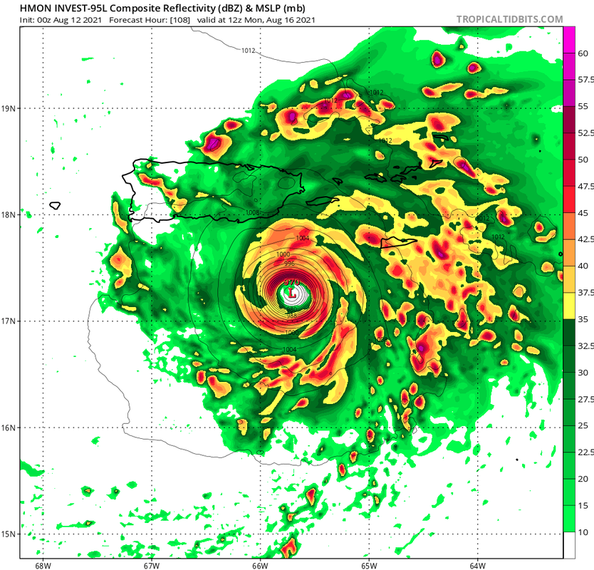
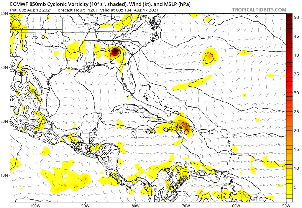
For 95L? Probably because it's just under 2 weeks away from any sort of impact, wherever it goes. Too many variables for them to start really trying to get people's attention.
0 likes   
Personal Forecast Disclaimer:
The posts in this forum are NOT official forecast and should not be used as such. They are just the opinion of the poster and may or may not be backed by sound meteorological data. They are NOT endorsed by any professional institution or storm2k.org. For official information, please refer to the NHC and NWS products.

AxaltaRacing24
Category 5
Category 5
Posts: 1710
Age: 24
Joined: Wed Jul 27, 2016 11:14 am
Location: Jupiter, FL

Re: ATL: 95L - Models

#65 Postby AxaltaRacing24 » Thu Aug 12, 2021 12:27 am

HMON :double:
0 likes   

User avatar
AubreyStorm
Category 1
Category 1
Posts: 322
Age: 43
Joined: Fri Jun 16, 2017 6:21 pm
Location: Texas, USA

Re: ATL: 95L - Models

#66 Postby AubreyStorm » Thu Aug 12, 2021 12:28 am

AxaltaRacing24 wrote:HMON :double:


Link…!!! Please
0 likes   
The posts are NOT an official forecast. Please REFER to the NHC and NWS for official forecasts and products.

User avatar
AtlanticWind
S2K Supporter
S2K Supporter
Posts: 1809
Age: 65
Joined: Sun Aug 08, 2004 9:57 pm
Location: Plantation,Fla

Re: ATL: 95L - Models

#67 Postby AtlanticWind » Thu Aug 12, 2021 12:29 am

HMON with stronger 997 mb storm coming into the islands, HWRF a little stronger so far
0 likes   

AxaltaRacing24
Category 5
Category 5
Posts: 1710
Age: 24
Joined: Wed Jul 27, 2016 11:14 am
Location: Jupiter, FL

Re: ATL: 95L - Models

#68 Postby AxaltaRacing24 » Thu Aug 12, 2021 12:30 am

AubreyStorm wrote:
AxaltaRacing24 wrote:HMON :double:


Link…!!! Please

Image
1 likes   

User avatar
Hurricaneman
Category 5
Category 5
Posts: 7284
Age: 43
Joined: Tue Aug 31, 2004 3:24 pm
Location: central florida

Re: ATL: 95L - Models

#69 Postby Hurricaneman » Thu Aug 12, 2021 12:36 am

Seems as though the models are playing catch-up with the development of this system which seems to be common the last year or 2
3 likes   

IcyTundra
Category 3
Category 3
Posts: 893
Joined: Mon Jun 07, 2021 9:32 pm
Location: Dickinson, Texas

Re: ATL: 95L - Models

#70 Postby IcyTundra » Thu Aug 12, 2021 12:38 am

Wow the HMON has 95L developing into a TS by hour 30 at 998 MB. I would be surprised if it develops that fast but I do think the global models are a bit too bearish on 95L's future.
0 likes   

User avatar
ElectricStorm
Category 5
Category 5
Posts: 4623
Age: 23
Joined: Tue Aug 13, 2019 11:23 pm
Location: Skiatook, OK / Norman, OK

Re: ATL: 95L - Models

#71 Postby ElectricStorm » Thu Aug 12, 2021 12:40 am

Whoa HMON says it's time to take this seriously :double:

We'll see how this plays out over the next few days...
0 likes   
I am in no way a professional. Take what I say with a grain of salt as I could be totally wrong. Please refer to the NHC, NWS, or SPC for official information.

Boomer Sooner!

AxaltaRacing24
Category 5
Category 5
Posts: 1710
Age: 24
Joined: Wed Jul 27, 2016 11:14 am
Location: Jupiter, FL

Re: ATL: 95L - Models

#72 Postby AxaltaRacing24 » Thu Aug 12, 2021 12:46 am

hr 108
Image
0 likes   

User avatar
ElectricStorm
Category 5
Category 5
Posts: 4623
Age: 23
Joined: Tue Aug 13, 2019 11:23 pm
Location: Skiatook, OK / Norman, OK

Re: ATL: 95L - Models

#73 Postby ElectricStorm » Thu Aug 12, 2021 12:48 am

HWRF coming into the islands much weaker than HMON but they both take the southern route.
0 likes   
I am in no way a professional. Take what I say with a grain of salt as I could be totally wrong. Please refer to the NHC, NWS, or SPC for official information.

Boomer Sooner!

AxaltaRacing24
Category 5
Category 5
Posts: 1710
Age: 24
Joined: Wed Jul 27, 2016 11:14 am
Location: Jupiter, FL

Re: ATL: 95L - Models

#74 Postby AxaltaRacing24 » Thu Aug 12, 2021 12:53 am

Weather Dude wrote:HWRF coming into the islands much weaker than HMON but they both take the southern route.

For PR's sake, I'd hope the HMON is way off.
2 likes   

User avatar
ElectricStorm
Category 5
Category 5
Posts: 4623
Age: 23
Joined: Tue Aug 13, 2019 11:23 pm
Location: Skiatook, OK / Norman, OK

Re: ATL: 95L - Models

#75 Postby ElectricStorm » Thu Aug 12, 2021 12:55 am

AxaltaRacing24 wrote:
Weather Dude wrote:HWRF coming into the islands much weaker than HMON but they both take the southern route.

For PR's sake, I'd hope the HMON is way off.

It likely will be but yeah that's definitely a doom run for PR

Meanwhile the HWRF shows an open wave :D
0 likes   
I am in no way a professional. Take what I say with a grain of salt as I could be totally wrong. Please refer to the NHC, NWS, or SPC for official information.

Boomer Sooner!

AxaltaRacing24
Category 5
Category 5
Posts: 1710
Age: 24
Joined: Wed Jul 27, 2016 11:14 am
Location: Jupiter, FL

Re: ATL: 95L - Models

#76 Postby AxaltaRacing24 » Thu Aug 12, 2021 1:04 am

Image

This is how it ends...
0 likes   

AxaltaRacing24
Category 5
Category 5
Posts: 1710
Age: 24
Joined: Wed Jul 27, 2016 11:14 am
Location: Jupiter, FL

Re: ATL: 95L - Models

#77 Postby AxaltaRacing24 » Thu Aug 12, 2021 1:07 am

Weather Dude wrote:
AxaltaRacing24 wrote:
Weather Dude wrote:HWRF coming into the islands much weaker than HMON but they both take the southern route.

For PR's sake, I'd hope the HMON is way off.

It likely will be but yeah that's definitely a doom run for PR

Meanwhile the HWRF shows an open wave :D

I mean, it's under 5 days out, the wave looks good, and it is getting later into August. So definitely something to watch. We shall see if this was a fluke run, or if the HMON shows continuity.
0 likes   

User avatar
Hurricaneman
Category 5
Category 5
Posts: 7284
Age: 43
Joined: Tue Aug 31, 2004 3:24 pm
Location: central florida

Re: ATL: 95L - Models

#78 Postby Hurricaneman » Thu Aug 12, 2021 1:09 am

The op Euro seems to be slowly coming aboard
0 likes   

User avatar
ElectricStorm
Category 5
Category 5
Posts: 4623
Age: 23
Joined: Tue Aug 13, 2019 11:23 pm
Location: Skiatook, OK / Norman, OK

Re: ATL: 95L - Models

#79 Postby ElectricStorm » Thu Aug 12, 2021 1:09 am

AxaltaRacing24 wrote:
Weather Dude wrote:
AxaltaRacing24 wrote:For PR's sake, I'd hope the HMON is way off.

It likely will be but yeah that's definitely a doom run for PR

Meanwhile the HWRF shows an open wave :D

I mean, it's under 5 days out, the wave looks good, and it is getting later into August. So definitely something to watch. We shall see if this was a fluke run, or if the HMON shows continuity.

It's definitely got some potential for sure
0 likes   
I am in no way a professional. Take what I say with a grain of salt as I could be totally wrong. Please refer to the NHC, NWS, or SPC for official information.

Boomer Sooner!

AxaltaRacing24
Category 5
Category 5
Posts: 1710
Age: 24
Joined: Wed Jul 27, 2016 11:14 am
Location: Jupiter, FL

Re: ATL: 95L - Models

#80 Postby AxaltaRacing24 » Thu Aug 12, 2021 1:23 am

Image

Euro runs it into the shredder.
0 likes   


Return to “2021”

Who is online

Users browsing this forum: No registered users and 4 guests