ATL: FRED - Post-Tropical - Discussion
Moderator: S2k Moderators
-
Weatherboy1

- Category 5

- Posts: 1190
- Age: 50
- Joined: Mon Jul 05, 2004 1:50 pm
- Location: Jupiter/Sarasota, FL
Re: ATL: SIX - Potential Tropical Cyclone - Discussion
I would be shocked ... like Capt. Louis Renault in Casablanca talking about gambling shocked ... if this thing doesn't get upgraded to Fred at 5 p.m. Everything looks good to me as far as this being a TS (though not yet a strong one)
1 likes

Re: ATL: SIX - Potential Tropical Cyclone - Discussion
[youtube]https://youtu.be/JDMHxIoqbQg[/youtube]
3 likes
-
SFLcane

- S2K Supporter

- Posts: 10281
- Age: 48
- Joined: Sat Jun 05, 2010 1:44 pm
- Location: Lake Worth Florida
Re: ATL: SIX - Potential Tropical Cyclone - Discussion
Weatherboy1 wrote:I would be shocked ... like Capt. Louis Renault in Casablanca talking about gambling shocked ... if this thing doesn't get upgraded to Fred at 5 p.m. Everything looks good to me as far as this being a TS (though not yet a strong one)
No recon more then likely at 11pm tonight
0 likes
-
ElectricStorm

- Category 5
- Posts: 5148
- Age: 25
- Joined: Tue Aug 13, 2019 11:23 pm
- Location: Norman, OK
Re: ATL: SIX - Potential Tropical Cyclone - Discussion
No TS yet on BT
06L SIX 210810 1800 16.6N 64.8W ATL 30 1012
Of course NHC could change that at the next advisory if they want.
06L SIX 210810 1800 16.6N 64.8W ATL 30 1012
Of course NHC could change that at the next advisory if they want.
0 likes
B.S Meteorology, University of Oklahoma '25
Please refer to the NHC, NWS, or SPC for official information.
Please refer to the NHC, NWS, or SPC for official information.
-
Blown Away

- S2K Supporter
- Posts: 10253
- Joined: Wed May 26, 2004 6:17 am
Re: ATL: SIX - Potential Tropical Cyclone - Discussion
GCANE wrote:I am thinking 17.1N 64.5W
Agree, could ramp up to strong TS/Cat before skimming PR. JMHO
1 likes
Hurricane Eye Experience: David 79, Irene 99, Frances 04, Jeanne 04, Wilma 05… Hurricane Brush Experience: Andrew 92, Erin 95, Floyd 99, Matthew 16, Irma 17, Ian 22, Nicole 22…
-
tolakram
- Admin

- Posts: 20186
- Age: 62
- Joined: Sun Aug 27, 2006 8:23 pm
- Location: Florence, KY (name is Mark)
Re: ATL: SIX - Potential Tropical Cyclone - Discussion
Can't be upgraded until 11 at the earliest. I have a prediction to win.
12 likes
M a r k
- - - - -
Join us in chat: Storm2K Chatroom Invite. Android and IOS apps also available.
The posts in this forum are NOT official forecasts and should not be used as such. Posts are NOT endorsed by any professional institution or STORM2K.org. For official information and forecasts, please refer to NHC and NWS products.
-
SFLcane
- S2K Supporter
- Posts: 10281
- Age: 48
- Joined: Sat Jun 05, 2010 1:44 pm
- Location: Lake Worth Florida
Re: ATL: SIX - Potential Tropical Cyclone - Discussion
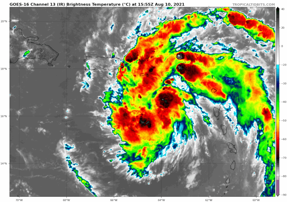
Best it’s ever looked on satellite Now getting that S look. Convection now on the south side.
8 likes

Re: ATL: SIX - Potential Tropical Cyclone - Discussion
Looks like LL convergence as it approaches PR is increasing due frictional effects.
Likely will see this ramp up more quickly now as it gets closer to the island.
If it skirts the south shore, this could be pretty dramatic.
Likely will see this ramp up more quickly now as it gets closer to the island.
If it skirts the south shore, this could be pretty dramatic.
0 likes

Re: ATL: SIX - Potential Tropical Cyclone - Discussion
It has really pulled itself together.the couple of hours. What is most impressive is this happened during DMIN.
It likely has tropical storm winds, but I don't know if the NHC will upgrade until there is proof of a closed low. I am certain this will be Fred when upgraded as it likely already has tropical storm winds, even if the low has not closed off.
It likely has tropical storm winds, but I don't know if the NHC will upgrade until there is proof of a closed low. I am certain this will be Fred when upgraded as it likely already has tropical storm winds, even if the low has not closed off.
4 likes

Re: ATL: SIX - Potential Tropical Cyclone - Discussion
Obviously satellite imagery can be misleading, but it certainly looks more like a closed system than it did at 11.
Sent from my SM-G988U1 using Tapatalk
Sent from my SM-G988U1 using Tapatalk
0 likes
-
HurricaneEnzo

- Category 2

- Posts: 744
- Joined: Wed Mar 14, 2018 12:18 pm
- Location: Newport, NC (Hurricane Alley)
Re: ATL: SIX - Potential Tropical Cyclone - Discussion
A beaut.

Sent from my SM-N986U1 using Tapatalk
Sent from my SM-N986U1 using Tapatalk
8 likes
Bertha 96' - Fran 96' - Bonnie 98' - Dennis 99' - Floyd 99' - Isabel 03' - Alex 04' - Ophelia 05' - Irene 11' - Arthur 14' - Matthew 16' - Florence 18' - Dorian 19' - Isaias 20' (countless other tropical storms and Hurricane swipes)
I am not a Professional Met just an enthusiast. Get your weather forecasts from the Pros!
I am not a Professional Met just an enthusiast. Get your weather forecasts from the Pros!
-
Blown Away
- S2K Supporter
- Posts: 10253
- Joined: Wed May 26, 2004 6:17 am
Re: ATL: SIX - Potential Tropical Cyclone - Discussion

2:00 PM AST Tue Aug 10
Location: 16.6°N 64.8°W
JMHO, I think we are seeing the LLC forming near 17.0N/64.5W, just NE of the 2pm position.
0 likes
Hurricane Eye Experience: David 79, Irene 99, Frances 04, Jeanne 04, Wilma 05… Hurricane Brush Experience: Andrew 92, Erin 95, Floyd 99, Matthew 16, Irma 17, Ian 22, Nicole 22…
Re: ATL: SIX - Potential Tropical Cyclone - Discussion
Persistent hot tower with tons of helicity.
Game On.
Game On.
5 likes
-
Weatherboy1
- Category 5
- Posts: 1190
- Age: 50
- Joined: Mon Jul 05, 2004 1:50 pm
- Location: Jupiter/Sarasota, FL
Re: ATL: SIX - Potential Tropical Cyclone - Discussion
SFLcane wrote:Weatherboy1 wrote:I would be shocked ... like Capt. Louis Renault in Casablanca talking about gambling shocked ... if this thing doesn't get upgraded to Fred at 5 p.m. Everything looks good to me as far as this being a TS (though not yet a strong one)
No recon more then likely at 11pm tonight
I would normally agree if that was the path of least resistance and land that could be impacted wasn't close by. But PR getting close. Radar presentation has improved notably the last couple hours. And most importantly (to me), the only thing that was missing (a CDO-type feature/a few hours of strong convection firing over a potential "center") is no longer missing. Ergo, think it gets upgraded at 5. We'll see soon enough!
2 likes
-
ElectricStorm
- Category 5
- Posts: 5148
- Age: 25
- Joined: Tue Aug 13, 2019 11:23 pm
- Location: Norman, OK
Re: ATL: SIX - Potential Tropical Cyclone - Discussion
Yeah I'm guessing it might be closed off now and ready for a name. May get the upgrade at 5 but almost certainly today or tonight
0 likes
B.S Meteorology, University of Oklahoma '25
Please refer to the NHC, NWS, or SPC for official information.
Please refer to the NHC, NWS, or SPC for official information.
-
Aric Dunn
- Category 5
- Posts: 21238
- Age: 43
- Joined: Sun Sep 19, 2004 9:58 pm
- Location: Ready for the Chase.
- Contact:
Re: ATL: SIX - Potential Tropical Cyclone - Discussion
Recent radar and surface ob trends should pretty much do it for an upgrade.
4 likes
Note: If I make a post that is brief. Please refer back to previous posts for the analysis or reasoning. I do not re-write/qoute what my initial post said each time.
If there is nothing before... then just ask
Space & Atmospheric Physicist, Embry-Riddle Aeronautical University,
I believe the sky is falling...
If there is nothing before... then just ask
Space & Atmospheric Physicist, Embry-Riddle Aeronautical University,
I believe the sky is falling...
-
Hypercane_Kyle

- Category 5
- Posts: 3465
- Joined: Sat Mar 07, 2015 7:58 pm
- Location: Cape Canaveral, FL
Re: ATL: SIX - Potential Tropical Cyclone - Discussion
06L has definitely done a good job at sustaining convection today, instead of the ebb-and-flow we see with many weak systems.
Probably TS Fred at this point.
Probably TS Fred at this point.
1 likes
My posts are my own personal opinion, defer to the National Hurricane Center (NHC) and other NOAA products for decision making during hurricane season.
-
AutoPenalti
- Category 5
- Posts: 4091
- Age: 29
- Joined: Mon Aug 17, 2015 4:16 pm
- Location: Ft. Lauderdale, Florida
Re: ATL: SIX - Potential Tropical Cyclone - Discussion
Surface Obs likely going to show a sharp wave axis despite it's presentation until dry air diminishes.
0 likes
The posts in this forum are NOT official forecasts and should not be used as such. They are just the opinion of the poster and may or may not be backed by sound meteorological data. They are NOT endorsed by any professional institution or STORM2K. For official information, please refer to products from the NHC and NWS.
Model Runs Cheat Sheet:
GFS (5:30 AM/PM, 11:30 AM/PM)
HWRF, GFDL, UKMET, NAVGEM (6:30-8:00 AM/PM, 12:30-2:00 AM/PM)
ECMWF (1:45 AM/PM)
TCVN is a weighted averaged
-
tolakram
- Admin
- Posts: 20186
- Age: 62
- Joined: Sun Aug 27, 2006 8:23 pm
- Location: Florence, KY (name is Mark)
Re: ATL: SIX - Potential Tropical Cyclone - Discussion
saved loop

1 likes
M a r k
- - - - -
Join us in chat: Storm2K Chatroom Invite. Android and IOS apps also available.
The posts in this forum are NOT official forecasts and should not be used as such. Posts are NOT endorsed by any professional institution or STORM2K.org. For official information and forecasts, please refer to NHC and NWS products.
- - - - -
Join us in chat: Storm2K Chatroom Invite. Android and IOS apps also available.
The posts in this forum are NOT official forecasts and should not be used as such. Posts are NOT endorsed by any professional institution or STORM2K.org. For official information and forecasts, please refer to NHC and NWS products.
Who is online
Users browsing this forum: No registered users and 29 guests