SEASON_CANCELED wrote:tolakram wrote:HWRF 18Z
https://i.imgur.com/Jt9ftC9.gif
Literally a wanna-be Irma
You read my mind!
Moderator: S2k Moderators


SEASON_CANCELED wrote:tolakram wrote:HWRF 18Z
https://i.imgur.com/Jt9ftC9.gif
Literally a wanna-be Irma


Jr0d wrote:Hopefully the data from NOAA's upper air sampling mission will be in tomorrow morning's computer runs.
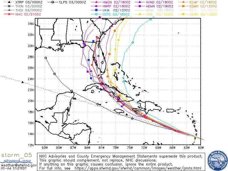
The HWRF nailed the 'struggle' we are seeing tonight. Overnight and into the morning it was showing Elsa consolidate then have another cycle of 'struggling' south of Haiti followed by explosive strengthening nas it approaches Cuba....
At this point it is tough to bet against the HWRF.
Clip From NHC 11pm Disco: The latest GFS and UKMET models indicate that Elsa will be moving into the center of a 300-200-mb synoptic-scale anticyclone, which would produce enhanced outflow jets to the north and south of the cyclone, resulting in significant strengthening.


hurricane2025 wrote:Euro been weak, icon, cmc, conditions just aren’t that favorable yet. Now gfs showing weak weak.

StPeteMike wrote:Only way this becomes a TD that fast is an out of the blue amount of shear or it starts moving 50 mph. What’s giving the models these issues? Many were doing fine, besides the EURO.
AxaltaRacing24 wrote:StPeteMike wrote:Only way this becomes a TD that fast is an out of the blue amount of shear or it starts moving 50 mph. What’s giving the models these issues? Many were doing fine, besides the EURO.
Might be the same issues as in 2020. Hopefully not.
Steve wrote:GFS hits between PCB and Cape San Blas Wed am as a mid grade 995 TS. CMC has a semi weak bounce off SFL from the south. Eh. It still prefers strengthening on the Atlantic side of Florida and hits SE NC before moving inland and then heading back offshore.
Users browsing this forum: No registered users and 51 guests


