
EPAC: ANDRES - Post-Tropical
Moderator: S2k Moderators
-
cycloneye

- Admin

- Posts: 139108
- Age: 67
- Joined: Thu Oct 10, 2002 10:54 am
- Location: San Juan, Puerto Rico
Re: EPAC: INVEST 90E
0 likes
Visit the Caribbean-Central America Weather Thread where you can find at first post web cams,radars
and observations from Caribbean basin members Click Here
and observations from Caribbean basin members Click Here


-
cycloneye
- Admin
- Posts: 139108
- Age: 67
- Joined: Thu Oct 10, 2002 10:54 am
- Location: San Juan, Puerto Rico
Re: EPAC: INVEST 90E
Special Tropical Weather Outlook
NWS National Hurricane Center Miami FL
705 PM PDT Fri May 7 2021
For the eastern North Pacific...east of 140 degrees west longitude:
Special Tropical Weather Outlook issued for an area of disturbed
weather southwest of Mexico.
An area of low pressure remains located several hundred miles
southwest of the southern coast of Mexico. The associated shower and
thunderstorm activity has become better organized since this
morning, and further development of this system is expected over the
next few days. A short-lived tropical depression or tropical storm
is now likely to form over the weekend or early next week before
environmental conditions become less favorable as the system moves
gradually west-northwestward.
* Formation chance through 48 hours...medium...60 percent.
* Formation chance through 5 days...high...70 percent.
The next Special Tropical Weather Outlook on this system will be
issued by 8 AM PDT Saturday morning, or earlier if conditions
warrant.
$$
Forecaster Papin/Brown

0 likes
Visit the Caribbean-Central America Weather Thread where you can find at first post web cams,radars
and observations from Caribbean basin members Click Here
and observations from Caribbean basin members Click Here
-
DorkyMcDorkface

- Category 2

- Posts: 704
- Age: 26
- Joined: Mon Sep 30, 2019 1:32 pm
- Location: Mid-Atlantic
Re: EPAC: INVEST 90E
Convective bursts near the "center", let's see how this evolves through the night. DMAX should help it.
0 likes
Floyd 1999 | Isabel 2003 | Hanna 2008 | Irene 2011 | Sandy 2012 | Isaias 2020
-
Sciencerocks
- Category 5

- Posts: 7286
- Age: 38
- Joined: Thu Jul 06, 2017 1:51 am
-
Kingarabian

- S2K Supporter

- Posts: 15437
- Joined: Sat Aug 08, 2009 3:06 am
- Location: Honolulu, Hawaii
-
ElectricStorm

- Category 5
- Posts: 4565
- Age: 23
- Joined: Tue Aug 13, 2019 11:23 pm
- Location: Skiatook, OK / Norman, OK
Re: EPAC: INVEST 90E
Haven't really been following this one all that closely but looking at it tonight it looks like it should be classified soon honestly...
1 likes
I am in no way a professional. Take what I say with a grain of salt as I could be totally wrong. Please refer to the NHC, NWS, or SPC for official information.
Boomer Sooner!
Boomer Sooner!
-
Kingarabian
- S2K Supporter
- Posts: 15437
- Joined: Sat Aug 08, 2009 3:06 am
- Location: Honolulu, Hawaii
Re: EPAC: INVEST 90E
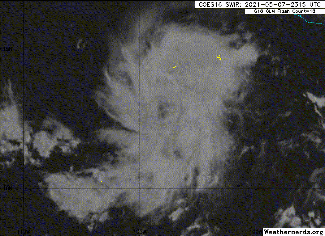
A. TROPICAL DISTURBANCE (90E)
B. 08/0530Z
C. 12.7N
D. 103.7W
E. THREE/GOES-W
F. T2.0/2.0
G. IR/EIR/SWIR/GMI
H. REMARKS...1.0 BANDING RESULTS IN A DT OF 3.5. MET=1.5 AND
PT=2.0. 0055Z GMI PASS REVEALED A TIGHT BANDING CENTER REFORMING TO SE
OF PREVIOUS POSITION. RAPID CONVECTIVE BURST LAST FEW HR. FT IS BASED ON
CONSTRAINTS LIMITING TO MAX OF 2.0 WITHIN FIRST 24 HR OF CLASSIFICATION.
I. ADDL POSITIONS
08/0055Z 12.4N 103.5W GMI
...KONON
0 likes
RIP Kobe Bryant
-
Nancy Smar

- Category 5
- Posts: 1081
- Age: 23
- Joined: Wed Aug 16, 2017 10:03 pm
Re: EPAC: INVEST 90E
ZCZC MIATWOEP ALL
TTAA00 KNHC DDHHMM
Tropical Weather Outlook
NWS National Hurricane Center Miami FL
1100 PM PDT Fri May 7 2021
For the eastern North Pacific...east of 140 degrees west longitude:
Special Tropical Weather Outlook issued for an area of disturbed
weather southwest of Mexico.
1. Satellite images indicate that showers and thunderstorms associated
with the low pressure system located several hundred miles
southwest of the southern coast of Mexico continue to become better
organized. Further development of this system is expected over the
next couple of days and a short-lived tropical depression or
tropical storm is likely to form Saturday or on Sunday. By mid
next week, environmental conditions are expected to become less
favorable as the system moves gradually west-northwestward.
* Formation chance through 48 hours...high...70 percent.
* Formation chance through 5 days...high...70 percent.
The next Special Tropical Weather Outlook on this system will be
issued by 8 AM PDT Saturday, or earlier if conditions warrant.
Forecaster Roberts
ABPZ20 KNHC 080827
TWOEP
Special Tropical Weather Outlook
NWS National Hurricane Center Miami FL
130 AM PDT Sat May 8 2021
For the eastern North Pacific...east of 140 degrees west longitude:
Special Tropical Weather Outlook issued for an area of disturbed
weather southwest of Mexico.
Satellite images indicate that showers and thunderstorms associated
with the low pressure system located several hundred miles
southwest of the southern coast of Mexico continue to become better
organized. Further development of this system is expected over the
next couple of days and a short-lived tropical depression or
tropical storm is likely to form later today or on Sunday. By mid
next week, environmental conditions are expected to become less
favorable as the system moves gradually west-northwestward.
* Formation chance through 48 hours...high...70 percent.
* Formation chance through 5 days...high...70 percent.
The next Special Tropical Weather Outlook on this system will be
issued by 8 AM PDT today, or earlier if conditions warrant.
$$
Forecaster Roberts
0 likes
-
cycloneye
- Admin
- Posts: 139108
- Age: 67
- Joined: Thu Oct 10, 2002 10:54 am
- Location: San Juan, Puerto Rico
Re: EPAC: INVEST 90E
Up to 2.5.
A. TROPICAL DISTURBANCE (90E)
B. 08/1130Z
C. 12.4N
D. 105.3W
E. FIVE/GOES-W
F. T2.5/2.5
G. IR/EIR/SWIR/AMSR2
H. REMARKS...4/10 BANDING AROUND LLCC YIELDS DT OF 2.5. MET IS 2.0 AND
PT IS 2.5. FT IS BASED ON DT.
I. ADDL POSITIONS
08/0850Z 12.2N 104.3W AMSR2
...MLEVINE
B. 08/1130Z
C. 12.4N
D. 105.3W
E. FIVE/GOES-W
F. T2.5/2.5
G. IR/EIR/SWIR/AMSR2
H. REMARKS...4/10 BANDING AROUND LLCC YIELDS DT OF 2.5. MET IS 2.0 AND
PT IS 2.5. FT IS BASED ON DT.
I. ADDL POSITIONS
08/0850Z 12.2N 104.3W AMSR2
...MLEVINE
0 likes
Visit the Caribbean-Central America Weather Thread where you can find at first post web cams,radars
and observations from Caribbean basin members Click Here
and observations from Caribbean basin members Click Here
-
cycloneye
- Admin
- Posts: 139108
- Age: 67
- Joined: Thu Oct 10, 2002 10:54 am
- Location: San Juan, Puerto Rico
Re: EPAC: INVEST 90E
No change.
Special Tropical Weather Outlook
NWS National Hurricane Center Miami FL
730 AM PDT Sat May 8 2021
For the eastern North Pacific...east of 140 degrees west longitude:
Special Tropical Weather Outlook issued for an area of disturbed
weather southwest of Mexico.
Satellite images indicate that showers and thunderstorms associated
with the low pressure system located several hundred miles southwest
of the southern coast of Mexico have changed little in organization
overnight. However, conditions are conducive for further
development of this system over the next day or so, and a
short-lived tropical depression or tropical storm is likely to form
tonight or on Sunday. In 2-3 days, environmental conditions are
expected to become less favorable as the system moves
west-northwestward.
* Formation chance through 48 hours...high...70 percent.
* Formation chance through 5 days...high...70 percent.
The next Special Tropical Weather Outlook on this system will be
issued by 2 PM PDT today, or earlier if conditions warrant.
$$
Forecaster Latto
0 likes
Visit the Caribbean-Central America Weather Thread where you can find at first post web cams,radars
and observations from Caribbean basin members Click Here
and observations from Caribbean basin members Click Here
-
Yellow Evan

- Professional-Met

- Posts: 15953
- Age: 25
- Joined: Fri Jul 15, 2011 12:48 pm
- Location: Henderson, Nevada/Honolulu, HI
- Contact:
Re: EPAC: INVEST 90E
Looked better yesterday as dry air, perhaps at the low levels, is getting to it. Judging by its shape, mid-level shear might be getting to it even if it's upper level structure looks excellent.
0 likes
-
Sciencerocks
- Category 5
- Posts: 7286
- Age: 38
- Joined: Thu Jul 06, 2017 1:51 am
-
Kingarabian
- S2K Supporter
- Posts: 15437
- Joined: Sat Aug 08, 2009 3:06 am
- Location: Honolulu, Hawaii
-
Sciencerocks
- Category 5
- Posts: 7286
- Age: 38
- Joined: Thu Jul 06, 2017 1:51 am
Re: EPAC: INVEST 90E
This based on satellite estimates and visible satellite for the past 24 hours has probably been deserving.
0 likes
-
zeehag
- Tropical Storm

- Posts: 172
- Age: 75
- Joined: Sun Jul 17, 2011 9:49 pm
- Location: mazatlan,sinaloa, mexico, fixing patricia's mess.
- Contact:
Re: EPAC: INVEST 90E
we are glad this is going to be a short lived issue as many are still sailing epac waters returning home or to safety.
0 likes
-
Kingarabian
- S2K Supporter
- Posts: 15437
- Joined: Sat Aug 08, 2009 3:06 am
- Location: Honolulu, Hawaii
Re: EPAC: INVEST 90E
4 hour old ASCAT:

Only caught about 70% of the LLC. Close enough IMO.
Only caught about 70% of the LLC. Close enough IMO.
0 likes
RIP Kobe Bryant
-
ouragans

- Category 1

- Posts: 465
- Age: 52
- Joined: Sun Jun 12, 2011 12:09 pm
- Location: Abymes, Guadeloupe F.W.I
- Contact:
Re: EPAC: INVEST 90E
Special Tropical Weather Outlook
NWS National Hurricane Center Miami FL
220 PM PDT Sat May 8 2021
For the eastern North Pacific...east of 140 degrees west longitude:
Special Tropical Weather Outlook issued for an area of disturbed
weather southwest of Mexico.
Satellite images indicate that showers and thunderstorms associated
with the low pressure system located several hundred miles southwest
of the southern coast of Mexico continue to show signs of
organization. Conditions are conducive for further development of
this system over the next day or so, and a short-lived tropical
depression or tropical storm is likely to form tonight or on Sunday.
In 2 days or so, environmental conditions are expected to become
less favorable as the system moves west-northwestward.
* Formation chance through 48 hours...high...70 percent.
* Formation chance through 5 days...high...70 percent.
The next Special Tropical Weather Outlook on this system will be
issued by 8 PM PDT today, or earlier if conditions warrant.
0 likes
Personal forecast disclaimer
This post is a personal point of view, not an information. Please refer to official statements for life-threatening decisions.
David '79, Frederic '79, Hugo '89, Iris, Luis & Marilyn '95, Georges '98, Lenny '99, Dean '07, Irma '17, Maria '17, Fiona '22, Philippe '23, Tammy '23
16°13'33.3,"6N -61°36'39.5"W
-
Kingarabian
- S2K Supporter
- Posts: 15437
- Joined: Sat Aug 08, 2009 3:06 am
- Location: Honolulu, Hawaii
Re: EPAC: INVEST 90E
Will be moving into an area with slightly weaker mid level shear. Has about another 24 hours before upper level winds rip it apart.

0 likes
RIP Kobe Bryant
Re: EPAC: INVEST 90E

Amsu multi, although-subjective sat estimates were likely on the money with this one.
Being marginal and forecast to go ots... It may not ever receive the proper TD/TC classification in its life span.
Next.
0 likes
Who is online
Users browsing this forum: No registered users and 18 guests