ATL: ANA - Post-Tropical - Discussion

Moderator: S2k Moderators

Message
Author
Subtrop
Category 1
Category 1
Posts: 448
Joined: Sun Feb 21, 2021 9:45 pm

Re: ATL: INVEST 90L - Discussion

#21 Postby Subtrop » Thu May 20, 2021 4:40 pm

SUBJ/TROPICAL CYCLONE FORMATION ALERT (90L)//
WTNT21 KNGU 202200
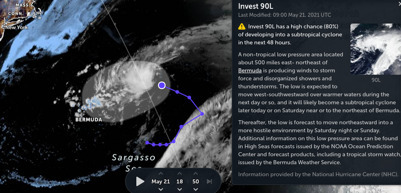
RMKS/1.FORMATION OF A SIGNIFICANT TROPICAL CYCLONE IS POSSIBLE WITHIN
100 NM EITHER SIDE OF A LINE FROM 34.4N 53.7W TO 36.3N 54.0W
WITHIN THE NEXT 24 HOURS. AVAILABLE DATA DOES NOT JUSTIFY
ISSUANCE OF NUMBERED TROPICAL CYCLONE WARNINGS AT THIS TIME.
WINDS IN THE AREA ARE ESTIMATED TO BE 40 TO 50 KNOTS. METSAT
IMAGERY AT 201800Z INDICATES THAT A CIRCULATION CENTER IS LOCATED
NEAR 34.4N 53.7W. THE SYSTEM IS MOVING NORTH-NORTHWESTWARD AT 05
KNOTS.
2.REMARKS: A NON-TROPICAL LOW PRESSURE SYSTEM IS SITUATED ABOUT 670
NM NORTHEAST OF BERMUDA. SATELLITE DERIVED WIND DATA INDICATE THAT
THE SYSTEM IS PRODUCING GALE-FORCE WINDS THAT EXTEND A FEW HUNDRED
MILES NORTH OF THE SURFACE CENTER. SHOWER AND THUNDERSTORM ACTIVITY
IS GRADUALLY BECOMING BETTER ORGANIZED AND THIS CONVECTIVE TREND
SHOULD CONTINUE THROUGH TONIGHT AND FRIDAY AS THE SYSTEM MOVES OVER
WARMER OCEANIC TEMPERATURES. CONSEQUENTLY, A SUBTROPICAL DEPRESSION
OR STORM IS LIKELY TO FORM DURING THE NEXT 24 HOURS AS THE LOW MOVES
WESTWARD TO WEST-SOUTHWESTWARD, REMAINING WELL TO THE NORTHEAST OF
BERMUDA.
3. THIS ALERT WILL BE REISSUED, UPGRADED TO WARNING OR CANCELLED BY
212200Z.//
BT
#0001
NNNN
0 likes   

User avatar
Nancy Smar
Category 5
Category 5
Posts: 1081
Age: 23
Joined: Wed Aug 16, 2017 10:03 pm

Re: ATL: INVEST 90L - Discussion

#22 Postby Nancy Smar » Thu May 20, 2021 7:09 pm

A developing low pressure to the east is expected to drift towards the area tomorrow and through the weekend bringing increasing winds, shower activity, and cloud cover. We continue to monitor this low for possible subtropical development. Regardless of development, the low will drive periods of wet weather into the area from Friday into the weekend. A tropical storm watch is now in effect.

Tropical Storm Watch
Updated: 4:30 pm Thursday, May 20, 2021
Additional Information:
A potential tropical or subtropical disturbance is developing approximately 600 nm east of Bermuda, but has not formed yet. A Tropical Storm Watch has been issued, to cover the potential for sustained winds reaching 35 knots and seas exceeding 12 feet offshore on Friday. For more detail, please review the Marine Forecast. Once formal advisories begin, BWS will start issuing Tropical Update Bulletins with more details about track and intensity.
0 likes   

User avatar
Hammy
Category 5
Category 5
Posts: 5594
Age: 40
Joined: Fri May 25, 2012 5:25 pm
Contact:

Re: ATL: INVEST 90L - Discussion

#23 Postby Hammy » Thu May 20, 2021 7:35 pm

Nancy Smar wrote:
A developing low pressure to the east is expected to drift towards the area tomorrow and through the weekend bringing increasing winds, shower activity, and cloud cover. We continue to monitor this low for possible subtropical development. Regardless of development, the low will drive periods of wet weather into the area from Friday into the weekend. A tropical storm watch is now in effect.

Tropical Storm Watch
Updated: 4:30 pm Thursday, May 20, 2021
Additional Information:
A potential tropical or subtropical disturbance is developing approximately 600 nm east of Bermuda, but has not formed yet. A Tropical Storm Watch has been issued, to cover the potential for sustained winds reaching 35 knots and seas exceeding 12 feet offshore on Friday. For more detail, please review the Marine Forecast. Once formal advisories begin, BWS will start issuing Tropical Update Bulletins with more details about track and intensity.


Has a tropical storm watch ever been issued prior to advisories being initiated?
0 likes   
The above post is not official and should not be used as such. It is the opinion of the poster and may or may not be backed by sound meteorological data. It is not endorsed by any professional institution or storm2k.org. For official information, please refer to the NHC and NWS products.

JW-_-
Category 1
Category 1
Posts: 281
Joined: Thu Mar 04, 2021 4:46 pm

Re: ATL: INVEST 90L - Discussion

#24 Postby JW-_- » Thu May 20, 2021 7:36 pm

0 likes   

User avatar
aspen
Category 5
Category 5
Posts: 8057
Joined: Sat Oct 12, 2019 7:10 pm
Location: Connecticut, USA

Re: ATL: INVEST 90L - Discussion

#25 Postby aspen » Thu May 20, 2021 8:08 pm

90L looks to be in the process of detaching from the front and consolidating. The 00z best track puts it at 50 kt, so if it becomes Ana, it’s starting off at a good intensity. 90L’s winds should decrease as it becomes subtropical but it’ll still be a better starting off point than TD-force tropical waves.

I’d say Ana’s maximum potential intensity as a named TC/STC is 50-55 kt.
0 likes   
Irene '11 Sandy '12 Hermine '16 5/15/2018 Derecho Fay '20 Isaias '20 Elsa '21 Henri '21 Ida '21

I am only a meteorology enthusiast who knows a decent amount about tropical cyclones. Look to the professional mets, the NHC, or your local weather office for the best information.

User avatar
cycloneye
Admin
Admin
Posts: 139086
Age: 67
Joined: Thu Oct 10, 2002 10:54 am
Location: San Juan, Puerto Rico

Re: ATL: INVEST 90L - Discussion

#26 Postby cycloneye » Thu May 20, 2021 8:10 pm

50kts.

90L INVEST 210521 0000 34.9N 55.0W ATL 50 1004
0 likes   
Visit the Caribbean-Central America Weather Thread where you can find at first post web cams,radars
and observations from Caribbean basin members Click Here

JW-_-
Category 1
Category 1
Posts: 281
Joined: Thu Mar 04, 2021 4:46 pm

Re: ATL: INVEST 90L - Discussion

#27 Postby JW-_- » Fri May 21, 2021 4:24 am

Image
0 likes   

User avatar
cycloneye
Admin
Admin
Posts: 139086
Age: 67
Joined: Thu Oct 10, 2002 10:54 am
Location: San Juan, Puerto Rico

Re: ATL: INVEST 90L - Discussion

#28 Postby cycloneye » Fri May 21, 2021 6:45 am

Showers and thunderstorms associated with a non-tropical low
pressure area centered about 450 miles east-northeast of Bermuda
have become better organized during the past several hours. The
low has not yet acquired subtropical storm characteristics.
However, if current trends continue advisories could be initiated
on the system later today or tonight as it moves westward
to west-southwestward to the northeast of Bermuda. Subsequently,
the low is forecast to move northeastward into a more hostile
environment by Saturday night or Sunday. Additional information on
this low pressure area can be found in High Seas forecasts issued by
the NOAA Ocean Prediction Center and forecast products, including a
tropical storm watch, issued by the Bermuda Weather Service.
* Formation chance through 48 hours...high...90 percent.
* Formation chance through 5 days...high...90 percent.
0 likes   
Visit the Caribbean-Central America Weather Thread where you can find at first post web cams,radars
and observations from Caribbean basin members Click Here

User avatar
Hypercane_Kyle
Category 5
Category 5
Posts: 2899
Joined: Sat Mar 07, 2015 7:58 pm
Location: Cape Canaveral, FL

Re: ATL: INVEST 90L - Discussion

#29 Postby Hypercane_Kyle » Fri May 21, 2021 7:58 am

Looking very good. Fully expecting STS Ana by 5 PM Eastern.

Image
6 likes   
My posts are my own personal opinion, defer to the National Hurricane Center (NHC) and other NOAA products for decision making during hurricane season.

User avatar
aspen
Category 5
Category 5
Posts: 8057
Joined: Sat Oct 12, 2019 7:10 pm
Location: Connecticut, USA

Re: ATL: INVEST 90L - Discussion

#30 Postby aspen » Fri May 21, 2021 8:02 am

Hypercane_Kyle wrote:Looking very good. Fully expecting STS Ana by 5 PM Eastern.

https://i.imgur.com/FHSSBTa.jpg

Convection could be better, but it seems to be fully detached now and ready to become a STC.
0 likes   
Irene '11 Sandy '12 Hermine '16 5/15/2018 Derecho Fay '20 Isaias '20 Elsa '21 Henri '21 Ida '21

I am only a meteorology enthusiast who knows a decent amount about tropical cyclones. Look to the professional mets, the NHC, or your local weather office for the best information.

User avatar
DorkyMcDorkface
Category 2
Category 2
Posts: 698
Age: 26
Joined: Mon Sep 30, 2019 1:32 pm
Location: Mid-Atlantic

Re: ATL: INVEST 90L - Discussion

#31 Postby DorkyMcDorkface » Fri May 21, 2021 8:20 am

I'd definitely say this is classifiable now...
Image
1 likes   
Floyd 1999 | Isabel 2003 | Hanna 2008 | Irene 2011 | Sandy 2012 | Isaias 2020

tolakram
Admin
Admin
Posts: 19165
Age: 60
Joined: Sun Aug 27, 2006 8:23 pm
Location: Florence, KY (name is Mark)

Re: ATL: INVEST 90L - Discussion

#32 Postby tolakram » Fri May 21, 2021 8:42 am

0 likes   
M a r k
- - - - -
Join us in chat: Storm2K Chatroom Invite. Android and IOS apps also available.

The posts in this forum are NOT official forecasts and should not be used as such. Posts are NOT endorsed by any professional institution or STORM2K.org. For official information and forecasts, please refer to NHC and NWS products.

User avatar
kevin
Category 5
Category 5
Posts: 1768
Age: 25
Joined: Wed Aug 28, 2019 4:35 am

Re: ATL: INVEST 90L - Discussion

#33 Postby kevin » Fri May 21, 2021 9:04 am

Looks pretty good right now.

1 likes   

Shell Mound
Category 5
Category 5
Posts: 2434
Age: 31
Joined: Thu Sep 07, 2017 3:39 pm
Location: St. Petersburg, FL → Scandinavia

Re: ATL: INVEST 90L - Discussion

#34 Postby Shell Mound » Fri May 21, 2021 9:24 am

Based on satellite, this clearly appears to be non-frontal at this stage and, given sufficient organisation, is already STS Ana, in my view. Upgrade at 15:00 UTC?
0 likes   
CVW / MiamiensisWx / Shell Mound
The posts in this forum are NOT official forecasts and should not be used as such. They are just the opinion of the poster and may or may not be backed by sound meteorological data. They are NOT endorsed by any professional institution or STORM2K. For official information, please refer to products from the NHC and NWS.

Sciencerocks
Category 5
Category 5
Posts: 7286
Age: 38
Joined: Thu Jul 06, 2017 1:51 am

Re: ATL: INVEST 90L - Discussion

#35 Postby Sciencerocks » Fri May 21, 2021 10:06 am

Image

Looks like Ana to me!
7 likes   

User avatar
lrak
S2K Supporter
S2K Supporter
Posts: 1770
Age: 57
Joined: Thu Jun 21, 2007 2:48 pm
Location: Corpus Christi, TX

Re: ATL: INVEST 90L - Discussion

#36 Postby lrak » Fri May 21, 2021 10:09 am

Surf!!!
0 likes   
AKA karl

Also
Personal Forecast Disclaimer:
My posts on this forum are NOT official forecast and should not be used as such. My posts are my basic observations and are definitely not backed by any "well some" meteorological knowledge. For official information, please refer to the NHC and NWS products.

User avatar
lrak
S2K Supporter
S2K Supporter
Posts: 1770
Age: 57
Joined: Thu Jun 21, 2007 2:48 pm
Location: Corpus Christi, TX

Re: ATL: INVEST 90L - Discussion

#37 Postby lrak » Fri May 21, 2021 10:11 am

lrak wrote:Surf!!!


ooops...
0 likes   
AKA karl

Also
Personal Forecast Disclaimer:
My posts on this forum are NOT official forecast and should not be used as such. My posts are my basic observations and are definitely not backed by any "well some" meteorological knowledge. For official information, please refer to the NHC and NWS products.

Shell Mound
Category 5
Category 5
Posts: 2434
Age: 31
Joined: Thu Sep 07, 2017 3:39 pm
Location: St. Petersburg, FL → Scandinavia

Re: ATL: INVEST 90L - Discussion

#38 Postby Shell Mound » Fri May 21, 2021 10:28 am

Sciencerocks wrote:https://imagizer.imageshack.com/img924/674/wGKcCZ.gif

Looks like Ana to me!

I’m a little surprised that the NHC didn’t upgrade 90L at STS Anna at 11:00 a.m. EDT (15:00 UTC). Does anyone know why? Convection seems sufficient.
1 likes   
CVW / MiamiensisWx / Shell Mound
The posts in this forum are NOT official forecasts and should not be used as such. They are just the opinion of the poster and may or may not be backed by sound meteorological data. They are NOT endorsed by any professional institution or STORM2K. For official information, please refer to products from the NHC and NWS.

Sciencerocks
Category 5
Category 5
Posts: 7286
Age: 38
Joined: Thu Jul 06, 2017 1:51 am

Re: ATL: INVEST 90L - Discussion

#39 Postby Sciencerocks » Fri May 21, 2021 10:31 am

Shell Mound wrote:
Sciencerocks wrote:https://imagizer.imageshack.com/img924/674/wGKcCZ.gif

Looks like Ana to me!

I’m a little surprised that the NHC didn’t upgrade 90L at STS Anna at 11:00 a.m. EDT (15:00 UTC). Does anyone know why? Convection seems sufficient.


I am guessing that they're waiting for solid evidence for a warm core as convection has only been building around the LLC for the past 8-9 hours and also for solid data for a complete detachment for the frontal structure. I am guessing they'll pull the trigger at 5pm est.
4 likes   

User avatar
aspen
Category 5
Category 5
Posts: 8057
Joined: Sat Oct 12, 2019 7:10 pm
Location: Connecticut, USA

Re: ATL: INVEST 90L - Discussion

#40 Postby aspen » Fri May 21, 2021 1:01 pm

There is a very clear LLC, but not much convection at all.
0 likes   
Irene '11 Sandy '12 Hermine '16 5/15/2018 Derecho Fay '20 Isaias '20 Elsa '21 Henri '21 Ida '21

I am only a meteorology enthusiast who knows a decent amount about tropical cyclones. Look to the professional mets, the NHC, or your local weather office for the best information.


Return to “2021”

Who is online

Users browsing this forum: No registered users and 63 guests