WPAC: CHOI-WAN - Post-Tropical

Moderator: S2k Moderators

Message
Author
User avatar
Kingarabian
S2K Supporter
S2K Supporter
Posts: 15437
Joined: Sat Aug 08, 2009 3:06 am
Location: Honolulu, Hawaii

Re: WPAC: Tropical Depression 04W

#21 Postby Kingarabian » Sun May 30, 2021 4:26 am

SSD fixed it @ 6N1/132.7E about 3 hours ago. Comparing it with infrared satellite imagery, the LLC was tucked beneath the large convection mass.


TXPQ22 KNES 300620
TCSWNP

A. 04W (NONAME)

B. 30/0530Z

C. 6.0N

D. 132.7E

E. THREE/HIMAWARI-8

F. T3.0/3.0

G. IR/EIR/SWIR/VIS

H. REMARKS...THIS INTENSITY ESTIMATE WAS DERIVED USING 4 KM IR
DATA. 9.5/10 BANDING YIELDS A DT OF 3.5. THE MET IS EQUAL TO 2.5 BASED
ON A RAPID DEVELOPMENT TREND OVER THE PAST 24 HOURS. PT IS EQUAL TO
3.0. FT IS BASED ON PT.

I. ADDL POSITIONS

NIL


...COVERDALE
0 likes   
RIP Kobe Bryant

Subtrop
Category 1
Category 1
Posts: 448
Joined: Sun Feb 21, 2021 9:45 pm

Re: WPAC: Tropical Depression 04W

#22 Postby Subtrop » Sun May 30, 2021 7:54 am

04W FOUR 210530 1200 6.9N 131.9E WPAC 35 1000
0 likes   

User avatar
Hayabusa
Category 5
Category 5
Posts: 3738
Joined: Sun Sep 16, 2018 1:05 pm

Re: WPAC: Tropical Depression 04W

#23 Postby Hayabusa » Sun May 30, 2021 7:14 pm

JMA CI 2.0 at 00Z looks like they gonna name it as Choi-wan now.
0 likes   
ヤンデレ女が寝取られるているのを見たい!!!
ECMWF ensemble NWPAC plots: https://ecmwfensnwpac.imgbb.com/
Multimodel NWPAC plots: https://multimodelnwpac.imgbb.com/
GFS Ensemble NWPAC plots (16 & 35 day forecast): https://gefsnwpac.imgbb.com/
Plots updated automatically

User avatar
Hayabusa
Category 5
Category 5
Posts: 3738
Joined: Sun Sep 16, 2018 1:05 pm

Re: WPAC: Tropical Depression 04W

#24 Postby Hayabusa » Sun May 30, 2021 7:32 pm

Last 2 GFS runs shifted to a landfall.
0 likes   
ヤンデレ女が寝取られるているのを見たい!!!
ECMWF ensemble NWPAC plots: https://ecmwfensnwpac.imgbb.com/
Multimodel NWPAC plots: https://multimodelnwpac.imgbb.com/
GFS Ensemble NWPAC plots (16 & 35 day forecast): https://gefsnwpac.imgbb.com/
Plots updated automatically

User avatar
Hayabusa
Category 5
Category 5
Posts: 3738
Joined: Sun Sep 16, 2018 1:05 pm

Re: WPAC: Tropical Depression 04W

#25 Postby Hayabusa » Sun May 30, 2021 7:40 pm

JTWC upgraded to 50 knots
04W FOUR 210531 0000 7.9N 130.7E WPAC 50 986
0 likes   
ヤンデレ女が寝取られるているのを見たい!!!
ECMWF ensemble NWPAC plots: https://ecmwfensnwpac.imgbb.com/
Multimodel NWPAC plots: https://multimodelnwpac.imgbb.com/
GFS Ensemble NWPAC plots (16 & 35 day forecast): https://gefsnwpac.imgbb.com/
Plots updated automatically

User avatar
DorkyMcDorkface
Category 2
Category 2
Posts: 705
Age: 26
Joined: Mon Sep 30, 2019 1:32 pm
Location: Mid-Atlantic

Re: WPAC: Tropical Depression 04W

#26 Postby DorkyMcDorkface » Sun May 30, 2021 7:47 pm

1 likes   
Floyd 1999 | Isabel 2003 | Hanna 2008 | Irene 2011 | Sandy 2012 | Isaias 2020

User avatar
Hayabusa
Category 5
Category 5
Posts: 3738
Joined: Sun Sep 16, 2018 1:05 pm

Re: WPAC: CHOI-WAN - Tropical Storm

#27 Postby Hayabusa » Sun May 30, 2021 8:38 pm

TY2103(Choi-wan)
Issued at 2021/05/31 01:30 UTC
Analisys at 05/31 00 UTC
Category TS
Scale -
Intensity -
Center Position N8°20′(8.3°)
E131°20′(131.3°)
Direction and speed of movement NNW 15km/h(9kt)
Central pressure 1000hPa
Maximum wind speed near the center 18m/s(35kt)
Maximum wind gust speed 25m/s(50kt)
30-kt wind area S220km(120NM)
N110km(60NM)
0 likes   
ヤンデレ女が寝取られるているのを見たい!!!
ECMWF ensemble NWPAC plots: https://ecmwfensnwpac.imgbb.com/
Multimodel NWPAC plots: https://multimodelnwpac.imgbb.com/
GFS Ensemble NWPAC plots (16 & 35 day forecast): https://gefsnwpac.imgbb.com/
Plots updated automatically

JW-_-
Category 1
Category 1
Posts: 281
Joined: Thu Mar 04, 2021 4:46 pm

Re: WPAC: CHOI-WAN - Tropical Storm

#28 Postby JW-_- » Mon May 31, 2021 1:04 am

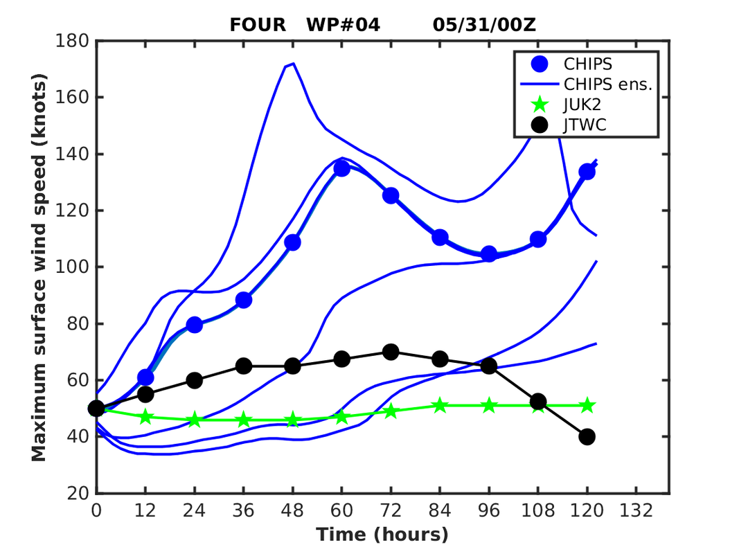
Image
Chips have some uncertainty leaving the door open with the eventual ceiling intensity of what this system could be.
0 likes   

User avatar
Hayabusa
Category 5
Category 5
Posts: 3738
Joined: Sun Sep 16, 2018 1:05 pm

Re: WPAC: CHOI-WAN - Tropical Storm

#29 Postby Hayabusa » Mon May 31, 2021 4:28 am

HWRF 00Z strongest run and most western track, cat 3 typhoon over the SCS
Image
0 likes   
ヤンデレ女が寝取られるているのを見たい!!!
ECMWF ensemble NWPAC plots: https://ecmwfensnwpac.imgbb.com/
Multimodel NWPAC plots: https://multimodelnwpac.imgbb.com/
GFS Ensemble NWPAC plots (16 & 35 day forecast): https://gefsnwpac.imgbb.com/
Plots updated automatically

User avatar
Hayabusa
Category 5
Category 5
Posts: 3738
Joined: Sun Sep 16, 2018 1:05 pm

Re: WPAC: CHOI-WAN - Tropical Storm

#30 Postby Hayabusa » Mon May 31, 2021 7:02 am

HWRF 06Z almost same in track first landfall just past 09Z tomorrow then passing just south of Manila, then becomes a major typhoon over the SCS, very interesting change of forecast.
0 likes   
ヤンデレ女が寝取られるているのを見たい!!!
ECMWF ensemble NWPAC plots: https://ecmwfensnwpac.imgbb.com/
Multimodel NWPAC plots: https://multimodelnwpac.imgbb.com/
GFS Ensemble NWPAC plots (16 & 35 day forecast): https://gefsnwpac.imgbb.com/
Plots updated automatically

User avatar
Hayabusa
Category 5
Category 5
Posts: 3738
Joined: Sun Sep 16, 2018 1:05 pm

Re: WPAC: CHOI-WAN - Tropical Storm

#31 Postby Hayabusa » Mon May 31, 2021 7:40 am

Image
0 likes   
ヤンデレ女が寝取られるているのを見たい!!!
ECMWF ensemble NWPAC plots: https://ecmwfensnwpac.imgbb.com/
Multimodel NWPAC plots: https://multimodelnwpac.imgbb.com/
GFS Ensemble NWPAC plots (16 & 35 day forecast): https://gefsnwpac.imgbb.com/
Plots updated automatically

User avatar
Hayabusa
Category 5
Category 5
Posts: 3738
Joined: Sun Sep 16, 2018 1:05 pm

Re: WPAC: CHOI-WAN - Tropical Storm

#32 Postby Hayabusa » Mon May 31, 2021 9:38 am

Landfall too but still on the east side.
Image
0 likes   
ヤンデレ女が寝取られるているのを見たい!!!
ECMWF ensemble NWPAC plots: https://ecmwfensnwpac.imgbb.com/
Multimodel NWPAC plots: https://multimodelnwpac.imgbb.com/
GFS Ensemble NWPAC plots (16 & 35 day forecast): https://gefsnwpac.imgbb.com/
Plots updated automatically

User avatar
ElectricStorm
Category 5
Category 5
Posts: 4566
Age: 23
Joined: Tue Aug 13, 2019 11:23 pm
Location: Skiatook, OK / Norman, OK

Re: WPAC: CHOI-WAN - Tropical Storm

#33 Postby ElectricStorm » Mon May 31, 2021 2:48 pm

04W CHOI-WAN 210531 1800 9.9N 128.5E WPAC 45 996

Hmm all the the previous 50kt points have been revised to 45kts as well.
0 likes   
I am in no way a professional. Take what I say with a grain of salt as I could be totally wrong. Please refer to the NHC, NWS, or SPC for official information.

Boomer Sooner!

User avatar
wxman57
Moderator-Pro Met
Moderator-Pro Met
Posts: 22482
Age: 66
Joined: Sat Jun 21, 2003 8:06 pm
Location: Houston, TX (southwest)

Re: WPAC: CHOI-WAN - Tropical Storm

#34 Postby wxman57 » Mon May 31, 2021 7:27 pm

It's a sheared mess with an exposed LLC. JTWC steadily backing away from the typhoon forecast. I think they were confused with the system to its east that the models were making a typhoon near Luzon.
0 likes   

User avatar
Meow
Tropical Depression
Tropical Depression
Posts: 66
Age: 34
Joined: Mon Aug 03, 2020 9:03 am
Location: New Taipei, Taiwan
Contact:

Re: WPAC: CHOI-WAN - Tropical Storm

#35 Postby Meow » Mon May 31, 2021 10:57 pm

The track is very special.

Image
0 likes   
Wikimedia User:Meow

User avatar
Hayabusa
Category 5
Category 5
Posts: 3738
Joined: Sun Sep 16, 2018 1:05 pm

Re: WPAC: CHOI-WAN - Tropical Storm

#36 Postby Hayabusa » Tue Jun 01, 2021 1:07 am

HWRF still makes this a strong typhoon over the SCS as it landfalls over Taiwan.
Image
0 likes   
ヤンデレ女が寝取られるているのを見たい!!!
ECMWF ensemble NWPAC plots: https://ecmwfensnwpac.imgbb.com/
Multimodel NWPAC plots: https://multimodelnwpac.imgbb.com/
GFS Ensemble NWPAC plots (16 & 35 day forecast): https://gefsnwpac.imgbb.com/
Plots updated automatically

User avatar
1900hurricane
Category 5
Category 5
Posts: 6044
Age: 33
Joined: Fri Feb 06, 2015 12:04 pm
Location: Houston, TX
Contact:

Re: WPAC: CHOI-WAN - Tropical Storm

#37 Postby 1900hurricane » Tue Jun 01, 2021 9:09 am

0 likes   
Contract Meteorologist. TAMU & MSST. Fiercely authentic, one of a kind. We are all given free will, so choose a life meant to be lived. We are the Masters of our own Stories.
Opinions expressed are mine alone.

Follow me on Twitter at @1900hurricane : Read blogs at https://1900hurricane.wordpress.com/

dexterlabio
Category 5
Category 5
Posts: 3407
Joined: Sat Oct 24, 2009 11:50 pm

Re: WPAC: CHOI-WAN - Tropical Storm

#38 Postby dexterlabio » Tue Jun 01, 2021 10:42 am

It's become clothed when the naked center was about to hit Samar island. Orographic lifting could be helping, maybe?
0 likes   
Personal Forecast Disclaimer:
The posts in this forum are NOT official forecast and should not be used as such. They are just the opinion of the poster and may or may not be backed by sound meteorological data. They are NOT endorsed by any professional institution or storm2k.org. For official information, please refer to the NHC and NWS products.

User avatar
wxman57
Moderator-Pro Met
Moderator-Pro Met
Posts: 22482
Age: 66
Joined: Sat Jun 21, 2003 8:06 pm
Location: Houston, TX (southwest)

Re: WPAC: CHOI-WAN - Tropical Storm

#39 Postby wxman57 » Tue Jun 01, 2021 1:31 pm

The center has been well NE of the convection for the past 36 hours. Strong NE wind shear drove all squalls well SW of the center. Here's the last visible shot from around 09Z this morning (4am CDT).

Image
0 likes   

User avatar
Hayabusa
Category 5
Category 5
Posts: 3738
Joined: Sun Sep 16, 2018 1:05 pm

Re: WPAC: CHOI-WAN - Tropical Storm

#40 Postby Hayabusa » Tue Jun 01, 2021 4:58 pm

Euro reintensifies to 985 mb near Sibuyan Sea then passing near Manila later
Image
0 likes   
ヤンデレ女が寝取られるているのを見たい!!!
ECMWF ensemble NWPAC plots: https://ecmwfensnwpac.imgbb.com/
Multimodel NWPAC plots: https://multimodelnwpac.imgbb.com/
GFS Ensemble NWPAC plots (16 & 35 day forecast): https://gefsnwpac.imgbb.com/
Plots updated automatically


Return to “2021”

Who is online

Users browsing this forum: No registered users and 23 guests