EPAC: CARLOS - Remnants

Moderator: S2k Moderators

Message
Author
User avatar
cycloneye
Admin
Admin
Posts: 139104
Age: 67
Joined: Thu Oct 10, 2002 10:54 am
Location: San Juan, Puerto Rico

Re: EPAC: CARLOS - Tropical Depression

#201 Postby cycloneye » Tue Jun 15, 2021 9:42 am

Tropical Depression Carlos Discussion Number 12
NWS National Hurricane Center Miami FL EP032021
800 AM PDT Tue Jun 15 2021

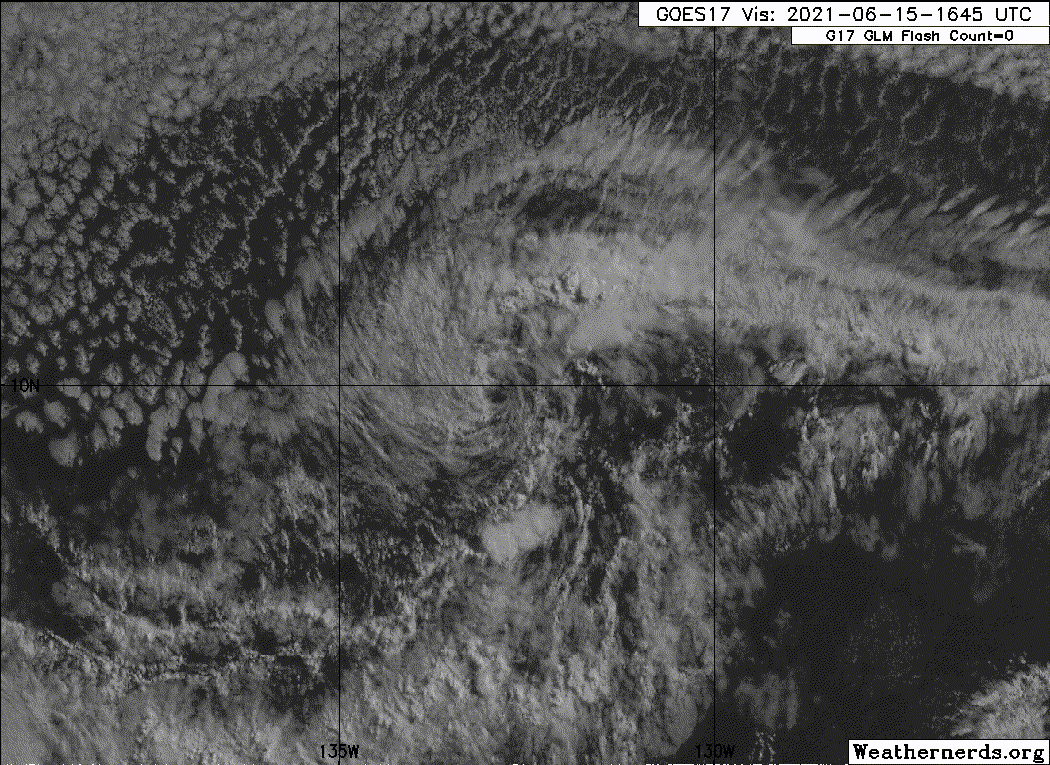
Several hours ago there was a burst of deep convection near the
center of Carlos. Although cloud tops are beginning to warm, this
convection gave Carlos a little more time as a tropical cyclone.
There has been no new ASCAT data since early yesterday to confirm
the strength of the cyclone's winds, and so the initial intensity is
set at a somewhat uncertain 30 kt for this advisory, which is in
agreement with the CIMSS ADT.

Carlos has begun to turn back to the west and is now on a heading
of 260/9 kt. This general motion, except for perhaps a slight
decrease in forward speed is expected for the remainder of the
cyclone's existence, as it is steered by a low- to mid-level ridge
to its north. The latest NHC track forecast is little changed from
the previous one and lies near the multi-model consensus.

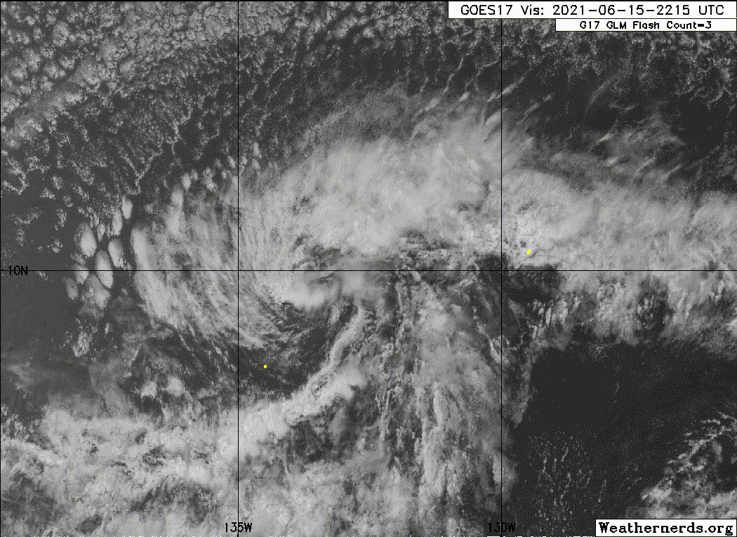
Dry and stable air along with strong vertical wind shear that
have been disrupting the depression's convection will continue to
affect the cyclone for the foreseeable future. Due to the warm
underlying waters, there still may be some short-lived convective
bursts near the center of Carlos over the next couple of days.
In about 2 days, the shear vector will shift from southwest to
northwest as an upper trough north of the depression shifts east.
This subsident pattern should put an end to any chances for
organized deep convection to return. The NHC forecast calls for
Carlos to degenerate into a remnant low by 24 h. However, that
timing is uncertain, and Carlos could remain a tropical cyclone
until the upper-level flow shifts in a couple of days. Once a
remnant low, the system should dissipate within a day or two.


FORECAST POSITIONS AND MAX WINDS

INIT 15/1500Z 10.0N 132.6W 30 KT 35 MPH
12H 16/0000Z 9.8N 133.9W 25 KT 30 MPH
24H 16/1200Z 9.7N 135.4W 25 KT 30 MPH...POST-TROP/REMNT LOW
36H 17/0000Z 9.7N 136.6W 25 KT 30 MPH...POST-TROP/REMNT LOW
48H 17/1200Z 9.7N 138.0W 25 KT 30 MPH...POST-TROP/REMNT LOW
60H 18/0000Z 9.9N 139.5W 20 KT 25 MPH...POST-TROP/REMNT LOW
72H 18/1200Z...DISSIPATED

$$
Forecaster Latto
0 likes   
Visit the Caribbean-Central America Weather Thread where you can find at first post web cams,radars
and observations from Caribbean basin members Click Here

Sciencerocks
Category 5
Category 5
Posts: 7286
Age: 38
Joined: Thu Jul 06, 2017 1:51 am

Re: EPAC: CARLOS - Tropical Depression

#202 Postby Sciencerocks » Tue Jun 15, 2021 3:10 pm

Image
0 likes   

User avatar
cycloneye
Admin
Admin
Posts: 139104
Age: 67
Joined: Thu Oct 10, 2002 10:54 am
Location: San Juan, Puerto Rico

Re: EPAC: CARLOS - Tropical Depression

#203 Postby cycloneye » Tue Jun 15, 2021 3:49 pm

Tropical Depression Carlos Discussion Number 13
NWS National Hurricane Center Miami FL EP032021
200 PM PDT Tue Jun 15 2021

Dry, stable air and strong southwesterly shear continue to take
their toll on Carlos. The only deep convection associated with the
depression consists of a very small cluster just south of the
center, and another about 90 n mi northwest of the center. This
meager amount of shower activity is not sufficient to be considered
organized deep convection. Therefore if no significant convection
develops soon, then Carlos will be declared a remnant low. Despite
the lack of convection, a pair recent ASCAT overpasses showed
several wind vectors of 27-30 kt, so the initial intensity remains
30 kt for this advisory. The environment surrounding the depression
is not forecast to improve, so the vortex should gradually spin
down, with dissipation expected within a few days.

Carlos is moving just south of due west at 8 kt. This general motion
is expected to continue for the remainder of the cyclone's
existence, except for perhaps a slight decrease in forward speed and
turn to the right, as the system is steered by a low- to mid-level
ridge to its north. The latest NHC track forecast is little changed
from the previous one and lies near the multi-model consensus.


FORECAST POSITIONS AND MAX WINDS

INIT 15/2100Z 9.8N 133.5W 30 KT 35 MPH
12H 16/0600Z 9.6N 134.6W 25 KT 30 MPH
24H 16/1800Z 9.4N 135.9W 25 KT 30 MPH...POST-TROP/REMNT LOW
36H 17/0600Z 9.5N 137.2W 25 KT 30 MPH...POST-TROP/REMNT LOW
48H 17/1800Z 9.7N 138.3W 20 KT 25 MPH...POST-TROP/REMNT LOW
60H 18/0600Z 10.0N 139.6W 20 KT 25 MPH...POST-TROP/REMNT LOW
72H 18/1800Z...DISSIPATED

$$
Forecaster Latto
0 likes   
Visit the Caribbean-Central America Weather Thread where you can find at first post web cams,radars
and observations from Caribbean basin members Click Here

Sciencerocks
Category 5
Category 5
Posts: 7286
Age: 38
Joined: Thu Jul 06, 2017 1:51 am

Re: EPAC: CARLOS - Tropical Depression

#204 Postby Sciencerocks » Tue Jun 15, 2021 8:42 pm

Image
0 likes   

User avatar
cycloneye
Admin
Admin
Posts: 139104
Age: 67
Joined: Thu Oct 10, 2002 10:54 am
Location: San Juan, Puerto Rico

Re: EPAC: CARLOS - Tropical Depression

#205 Postby cycloneye » Tue Jun 15, 2021 9:40 pm

Still hanging on.

Tropical Depression Carlos Discussion Number 14
NWS National Hurricane Center Miami FL EP032021
500 PM HST Tue Jun 15 2021

Carlos continues to produce small, short-lived bursts of convection
near its center this evening. While this limited convection lacks
significant organization, it remains just active enough to hold onto
Carlos as a sheared tropical cyclone. The initial intensity is set
at 30 kt, which is consistent with several earlier ASCAT passes that
showed 25-30 kt winds in the northwest quadrant of the cyclone.

The depression continues moving just south of due west, or 260/07
kt. A gradual westward to west-northwestward turn is expected during
the next day or so as Carlos moves around the southern periphery of
a low- to mid-level ridge. Although sea-surface temperatures remain
warm enough along the forecast track to support more brief
convective pulses, 20-25 kt of westerly shear and limited mid-level
moisture will inhibit any organized convective development. Carlos
will move into a more subsident environment by 24 h, which should
seal its fate as it degenerates to a remnant low. The vortex is
expected to gradually spin down thereafter, and it should dissipate
by late this week. The latest NHC forecast is largely an update of
the previous one and lies near the latest multi-model consensus.


FORECAST POSITIONS AND MAX WINDS

INIT 16/0300Z 9.6N 134.2W 30 KT 35 MPH
12H 16/1200Z 9.5N 135.2W 25 KT 30 MPH
24H 17/0000Z 9.4N 136.4W 25 KT 30 MPH...POST-TROP/REMNT LOW
36H 17/1200Z 9.5N 137.5W 25 KT 30 MPH...POST-TROP/REMNT LOW
48H 18/0000Z 9.8N 138.8W 20 KT 25 MPH...POST-TROP/REMNT LOW
60H 18/1200Z 10.0N 140.3W 20 KT 25 MPH...POST-TROP/REMNT LOW
72H 19/0000Z...DISSIPATED

$$
Forecaster Reinhart/Beven
0 likes   
Visit the Caribbean-Central America Weather Thread where you can find at first post web cams,radars
and observations from Caribbean basin members Click Here

User avatar
cycloneye
Admin
Admin
Posts: 139104
Age: 67
Joined: Thu Oct 10, 2002 10:54 am
Location: San Juan, Puerto Rico

Re: EPAC: CARLOS - Remnants

#206 Postby cycloneye » Wed Jun 16, 2021 11:35 am

Post-Tropical Cyclone Carlos Discussion Number 16
NWS National Hurricane Center Miami FL EP032021
800 AM PDT Wed Jun 16 2021

Shortwave infrared satellite imagery suggests that Carlos's center
has become less defined since last evening's scatterometer passes,
and the overall circulation is losing definition as it becomes
embedded within the Intertropical Convergence Zone (ITCZ). Despite
the few sporadic bursts of convection that have been occurring, the
system has been unable to generate persistent organized deep
convection near its center for quite some time, and Carlos is
therefore being designated as a remnant low with maximum winds of
25 kt. Moderate westerly shear and ingestion of drier air should
cause the remnant low to weaken further, and likely dissipate within
the ITCZ in 2 to 3 days.

Geostationary and microwave imagery indicates that Carlos has sunk
a little farther south than previously estimated, and its 12-hour
heading has been toward the west-southwest (240/6 kt). The bulk of
the track models show that the remnant low should resume a westward
motion later today and then maintain a steady west to
west-northwest heading through Friday, steered by the low-level
trade winds. The new NHC official track forecast is a blend of the
previous forecast and the GFS-ECMWF consensus, and due to the
southward-adjusted initial position, is about a half a degree south
of the previous forecast.

This is the last advisory on Carlos. For additional information on
the remnant low please see High Seas Forecasts issued by the
National Weather Service, under AWIPS header NFDHSFEPI, WMO header
FZPN02 KWBC, and on the web at ocean.weather.gov/shtml/NFDHSFEPI.php


FORECAST POSITIONS AND MAX WINDS

INIT 16/1500Z 8.6N 135.3W 25 KT 30 MPH...POST-TROP/REMNT LOW
12H 17/0000Z 8.6N 136.2W 25 KT 30 MPH...POST-TROP/REMNT LOW
24H 17/1200Z 8.7N 137.4W 25 KT 30 MPH...POST-TROP/REMNT LOW
36H 18/0000Z 9.0N 138.5W 20 KT 25 MPH...POST-TROP/REMNT LOW
48H 18/1200Z 9.2N 140.0W 20 KT 25 MPH...POST-TROP/REMNT LOW
60H 19/0000Z...DISSIPATED

$$
Forecaster Berg
0 likes   
Visit the Caribbean-Central America Weather Thread where you can find at first post web cams,radars
and observations from Caribbean basin members Click Here

User avatar
Yellow Evan
Professional-Met
Professional-Met
Posts: 15952
Age: 25
Joined: Fri Jul 15, 2011 12:48 pm
Location: Henderson, Nevada/Honolulu, HI
Contact:

Re: EPAC: CARLOS - Remnants

#207 Postby Yellow Evan » Wed Jun 16, 2021 4:05 pm

Honestly the plug shouldn’t have been pulled as this is still producing convection.
2 likes   


Return to “2021”

Who is online

Users browsing this forum: No registered users and 11 guests