EPAC: CARLOS - Remnants
Moderator: S2k Moderators
-
Sciencerocks
- Category 5

- Posts: 7286
- Age: 38
- Joined: Thu Jul 06, 2017 1:51 am
-
Kingarabian

- S2K Supporter

- Posts: 15435
- Joined: Sat Aug 08, 2009 3:06 am
- Location: Honolulu, Hawaii
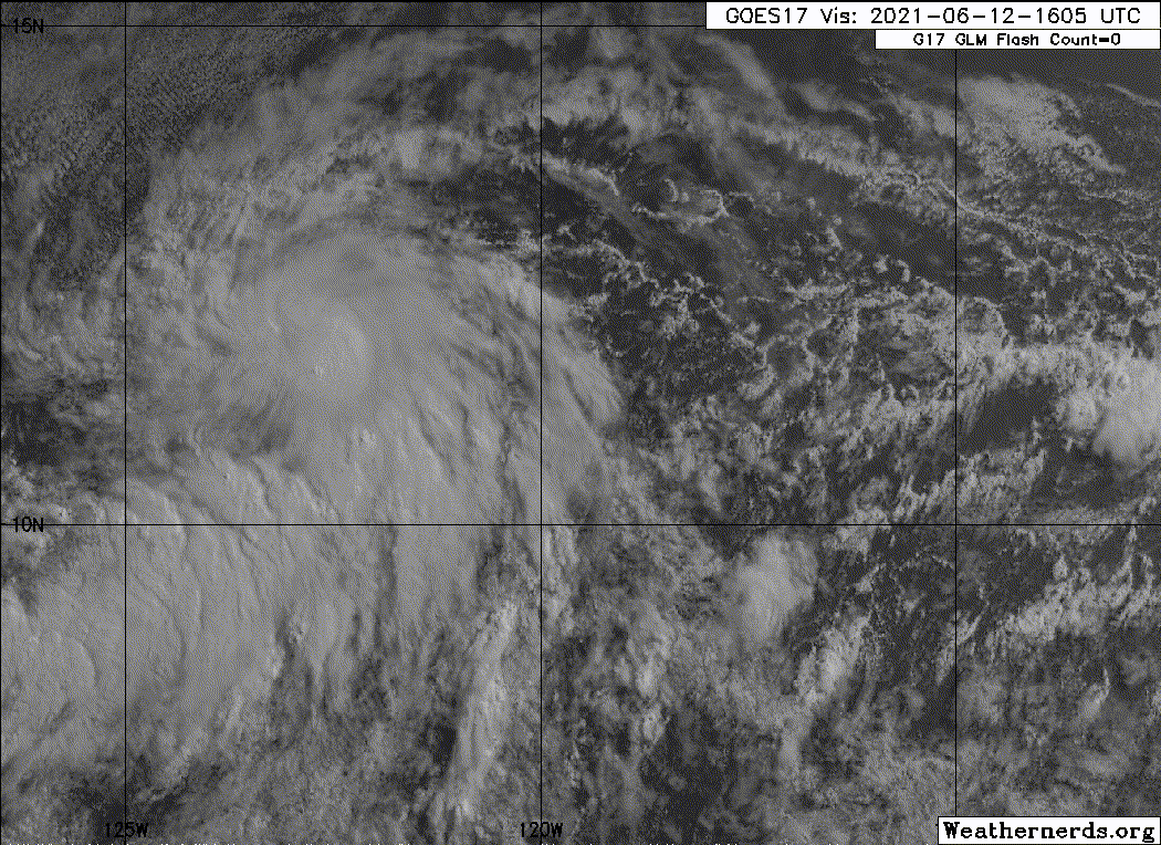
Re: EPAC: INVEST 92E
Looks better on visible compared to IR:


But it certainly does resemble a TC now. Much more traditional look.
But it certainly does resemble a TC now. Much more traditional look.
0 likes
RIP Kobe Bryant
-
Kingarabian
- S2K Supporter
- Posts: 15435
- Joined: Sat Aug 08, 2009 3:06 am
- Location: Honolulu, Hawaii
Re: EPAC: INVEST 92E
Yellow Evan wrote:2 questions.
1. Why is this still an invest?
2. Why is this 25 knots when ASCAT showed 30 knots?
Maybe they want it to persist longer before they declare it? That being said despite its shallow look, the overall structure looks very good. I don't get the NHC's conservatism when it comes to this system.
0 likes
RIP Kobe Bryant
-
cycloneye

- Admin

- Posts: 139094
- Age: 67
- Joined: Thu Oct 10, 2002 10:54 am
- Location: San Juan, Puerto Rico
Re: EPAC: Three-E - Tropical Depression
BULLETIN
Tropical Depression Three-E Advisory Number 1
NWS National Hurricane Center Miami FL EP032021
200 PM PDT Sat Jun 12 2021
...TROPICAL DEPRESSION FORMS OVER THE OPEN WATERS OF THE EAST
PACIFIC...
...EXPECTED TO BECOME A TROPICAL STORM SOON...
SUMMARY OF 200 PM PDT...2100 UTC...INFORMATION
----------------------------------------------
LOCATION...11.8N 123.6W
ABOUT 1185 MI...1905 KM SW OF THE SOUTHERN TIP OF BAJA CALIFORNIA
MAXIMUM SUSTAINED WINDS...35 MPH...55 KM/H
PRESENT MOVEMENT...W OR 275 DEGREES AT 9 MPH...15 KM/H
MINIMUM CENTRAL PRESSURE...1006 MB...29.71 INCHES
WATCHES AND WARNINGS
--------------------
There are no coastal watches or warnings in effect.
DISCUSSION AND OUTLOOK
----------------------
At 200 PM PDT (2100 UTC), the center of Tropical Depression Three-E
was located near latitude 11.8 North, longitude 123.6 West. The
depression is moving toward the west near 9 mph (15 km/h). A gradual
slowing of the forward motion is expected over the next few days
along with a turn toward the west-southwest and then southwest.
Maximum sustained winds are near 35 mph (55 km/h) with higher gusts.
Slow strengthening is expected over the next couple of days, and
the depression is forecast to become a tropical storm tonight.
The system is expected to begin weakening by Tuesday.
The estimated minimum central pressure is 1006 mb (29.71 inches).
HAZARDS AFFECTING LAND
----------------------
None.
NEXT ADVISORY
-------------
Next complete advisory at 800 PM PDT.
$$
Forecaster Latto
Tropical Depression Three-E Discussion Number 1
NWS National Hurricane Center Miami FL EP032021
200 PM PDT Sat Jun 12 2021
The disturbance that has been tracked westward for the past several
days across the open waters of the the tropical eastern Pacific has
finally established a sufficiently well-defined low-level
circulation to be designated as Tropical Depression Three-E.
Convection increased last night and began to consolidate, while
satellite images and microwave data this morning indicated that
there was evidence of a well-defined low developing. This was later
confirmed by a pair of ASCAT overpasses. These overpasses showed a
compact radius of maximum winds. And, although the ASCAT-A data
had a few vectors between 30-35 kt, these were not homogeneous and
appeared unrepresentative of the system's intensity. In addition,
the rather ragged satellite appearance and the Dvorak intensity
estimate of 2.0 from SAB are suggestive that this system should be
initialized as a 30-kt depression for this advisory.
The environment surrounding the depression is moderately conducive
for gradual strengthening, with SSTs of 27-28 degrees C, mid-level
RH values between 50-60 percent, and vertical wind shear of about
5-10 kt. These conditions are expected to continue for the next 2-3
days. By 72 h, dry air and subsidence are expected to hinder any
further intensification and should begin a weakening trend. By late
in the forecast period, the system is forecast to cross the 26
degree C isotherm, which should hasten the pace of weakening. The
official intensity closely follows the HFIP corrected consensus
HCCA, which shows the depression becoming a tropical storm tonight,
and levels off its intensity by 48 h, followed by a weakening trend
after 60 h.
A mid-level ridge to the north of the cyclone is steering it at a
somewhat uncertain 275/08 kt. This ridge is forecast by nearly all
of the models to weaken over the next couple of days, leaving the
depression in a region of very weak steering currents through
early next week. A mid-upper level trough digging southward to the
northwest of the cyclone should induce a northerly component of
motion along with an increase in forward speed by midweek. As
said, there is good agreement on the pattern, however, the models
vary greatly on how abruptly they slow the system. This is resulting
in a track model spread of about 300 n mi by 72 h. The NHC track
forecast tries to split the difference by closely following the TVCE
and TVCN consensus aids.
FORECAST POSITIONS AND MAX WINDS
INIT 12/2100Z 11.8N 123.6W 30 KT 35 MPH
12H 13/0600Z 11.9N 124.5W 35 KT 40 MPH
24H 13/1800Z 11.7N 125.5W 40 KT 45 MPH
36H 14/0600Z 11.4N 126.1W 45 KT 50 MPH
48H 14/1800Z 11.0N 126.5W 50 KT 60 MPH
60H 15/0600Z 10.8N 126.7W 50 KT 60 MPH
72H 15/1800Z 11.0N 126.9W 45 KT 50 MPH
96H 16/1800Z 12.5N 126.7W 40 KT 45 MPH
120H 17/1800Z 15.2N 126.1W 30 KT 35 MPH
$$
Forecaster Latto
1 likes
Visit the Caribbean-Central America Weather Thread where you can find at first post web cams,radars
and observations from Caribbean basin members Click Here
and observations from Caribbean basin members Click Here
-
Kingarabian
- S2K Supporter
- Posts: 15435
- Joined: Sat Aug 08, 2009 3:06 am
- Location: Honolulu, Hawaii
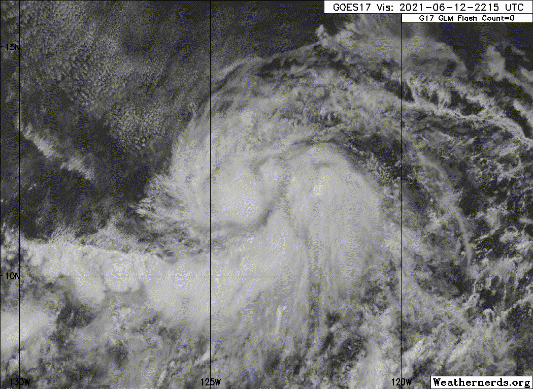
Re: EPAC: Three-E - Tropical Depression
5 hour old GMI pass clearly a TC:

Edit: There it is!
Edit:
0 likes
RIP Kobe Bryant
-
Kingarabian
- S2K Supporter
- Posts: 15435
- Joined: Sat Aug 08, 2009 3:06 am
- Location: Honolulu, Hawaii
-
Yellow Evan

- Professional-Met

- Posts: 15952
- Age: 25
- Joined: Fri Jul 15, 2011 12:48 pm
- Location: Henderson, Nevada/Honolulu, HI
- Contact:
Re: EPAC: THREE-E - Tropical Depression
The surrounding environment is so dry and as a result I doubt we see serious intensification. It’s going to live and die by the ITCZ feeder band, and this won’t stay in the deep tropics forever.
0 likes
-
Yellow Evan
- Professional-Met
- Posts: 15952
- Age: 25
- Joined: Fri Jul 15, 2011 12:48 pm
- Location: Henderson, Nevada/Honolulu, HI
- Contact:
Re: EPAC: THREE-E - Tropical Depression
Kingarabian wrote:https://twitter.com/cyclonicwx/status/1403750700237000709
The weird part is the current SST configuration suggests that the last thing you’d expect is a tropical cyclone so far west this time of year.
4 likes
-
Kingarabian
- S2K Supporter
- Posts: 15435
- Joined: Sat Aug 08, 2009 3:06 am
- Location: Honolulu, Hawaii
Re: EPAC: THREE-E - Tropical Depression
Yellow Evan wrote:Kingarabian wrote:https://twitter.com/cyclonicwx/status/1403750700237000709
The weird part is the current SST configuration suggests that the last thing you’d expect is a tropical cyclone so far west this time of year.
Agreed. Probably being aided by the abundant amount of rising motion over the CPAC/EPAC. It has been oddly easy for rising motion to situate and flare up convection over this region so far.

0 likes
RIP Kobe Bryant

Re: EPAC: Three-E - Tropical Depression
cycloneye wrote:BULLETIN
Tropical Depression Three-E Advisory Number 1
NWS National Hurricane Center Miami FL EP032021
200 PM PDT Sat Jun 12 2021
...TROPICAL DEPRESSION FORMS OVER THE OPEN WATERS OF THE EAST
PACIFIC...
...EXPECTED TO BECOME A TROPICAL STORM SOON...
SUMMARY OF 200 PM PDT...2100 UTC...INFORMATION
----------------------------------------------
LOCATION...11.8N 123.6W
ABOUT 1185 MI...1905 KM SW OF THE SOUTHERN TIP OF BAJA CALIFORNIA
MAXIMUM SUSTAINED WINDS...35 MPH...55 KM/H
PRESENT MOVEMENT...W OR 275 DEGREES AT 9 MPH...15 KM/H
MINIMUM CENTRAL PRESSURE...1006 MB...29.71 INCHES
WATCHES AND WARNINGS
--------------------
There are no coastal watches or warnings in effect.
DISCUSSION AND OUTLOOK
----------------------
At 200 PM PDT (2100 UTC), the center of Tropical Depression Three-E
was located near latitude 11.8 North, longitude 123.6 West. The
depression is moving toward the west near 9 mph (15 km/h). A gradual
slowing of the forward motion is expected over the next few days
along with a turn toward the west-southwest and then southwest.
Maximum sustained winds are near 35 mph (55 km/h) with higher gusts.
Slow strengthening is expected over the next couple of days, and
the depression is forecast to become a tropical storm tonight.
The system is expected to begin weakening by Tuesday.
The estimated minimum central pressure is 1006 mb (29.71 inches).
HAZARDS AFFECTING LAND
----------------------
None.
NEXT ADVISORY
-------------
Next complete advisory at 800 PM PDT.
$$
Forecaster Latto
Tropical Depression Three-E Discussion Number 1
NWS National Hurricane Center Miami FL EP032021
200 PM PDT Sat Jun 12 2021
The disturbance that has been tracked westward for the past several
days across the open waters of the the tropical eastern Pacific has
finally established a sufficiently well-defined low-level
circulation to be designated as Tropical Depression Three-E.
Convection increased last night and began to consolidate, while
satellite images and microwave data this morning indicated that
there was evidence of a well-defined low developing. This was later
confirmed by a pair of ASCAT overpasses. These overpasses showed a
compact radius of maximum winds. And, although the ASCAT-A data
had a few vectors between 30-35 kt, these were not homogeneous and
appeared unrepresentative of the system's intensity. In addition,
the rather ragged satellite appearance and the Dvorak intensity
estimate of 2.0 from SAB are suggestive that this system should be
initialized as a 30-kt depression for this advisory.
The environment surrounding the depression is moderately conducive
for gradual strengthening, with SSTs of 27-28 degrees C, mid-level
RH values between 50-60 percent, and vertical wind shear of about
5-10 kt. These conditions are expected to continue for the next 2-3
days. By 72 h, dry air and subsidence are expected to hinder any
further intensification and should begin a weakening trend. By late
in the forecast period, the system is forecast to cross the 26
degree C isotherm, which should hasten the pace of weakening. The
official intensity closely follows the HFIP corrected consensus
HCCA, which shows the depression becoming a tropical storm tonight,
and levels off its intensity by 48 h, followed by a weakening trend
after 60 h.
A mid-level ridge to the north of the cyclone is steering it at a
somewhat uncertain 275/08 kt. This ridge is forecast by nearly all
of the models to weaken over the next couple of days, leaving the
depression in a region of very weak steering currents through
early next week. A mid-upper level trough digging southward to the
northwest of the cyclone should induce a northerly component of
motion along with an increase in forward speed by midweek. As
said, there is good agreement on the pattern, however, the models
vary greatly on how abruptly they slow the system. This is resulting
in a track model spread of about 300 n mi by 72 h. The NHC track
forecast tries to split the difference by closely following the TVCE
and TVCN consensus aids.
FORECAST POSITIONS AND MAX WINDS
INIT 12/2100Z 11.8N 123.6W 30 KT 35 MPH
12H 13/0600Z 11.9N 124.5W 35 KT 40 MPH
24H 13/1800Z 11.7N 125.5W 40 KT 45 MPH
36H 14/0600Z 11.4N 126.1W 45 KT 50 MPH
48H 14/1800Z 11.0N 126.5W 50 KT 60 MPH
60H 15/0600Z 10.8N 126.7W 50 KT 60 MPH
72H 15/1800Z 11.0N 126.9W 45 KT 50 MPH
96H 16/1800Z 12.5N 126.7W 40 KT 45 MPH
120H 17/1800Z 15.2N 126.1W 30 KT 35 MPH
$$
Forecaster Latto
Finally, a long-deserved upgrade.
0 likes
Irene '11 Sandy '12 Hermine '16 5/15/2018 Derecho Fay '20 Isaias '20 Elsa '21 Henri '21 Ida '21
I am only a meteorology enthusiast who knows a decent amount about tropical cyclones. Look to the professional mets, the NHC, or your local weather office for the best information.
I am only a meteorology enthusiast who knows a decent amount about tropical cyclones. Look to the professional mets, the NHC, or your local weather office for the best information.
-
Kingarabian
- S2K Supporter
- Posts: 15435
- Joined: Sat Aug 08, 2009 3:06 am
- Location: Honolulu, Hawaii
Re: EPAC: THREE-E - Tropical Depression
Inner core is well defined now. Eyewall might be trying to form with this new burst of convection.


Look at all that yellow and green to the N and NE of it. Very dry environment once it starts moving NE. In the near term, I believe it's going to be dipping S/SSW in the next 36-48 hours. That should shield it and allow for further intensification. Latest 18z GFS shows this becoming a decent hurricane.
Look at all that yellow and green to the N and NE of it. Very dry environment once it starts moving NE. In the near term, I believe it's going to be dipping S/SSW in the next 36-48 hours. That should shield it and allow for further intensification. Latest 18z GFS shows this becoming a decent hurricane.
1 likes
RIP Kobe Bryant
-
Kingarabian
- S2K Supporter
- Posts: 15435
- Joined: Sat Aug 08, 2009 3:06 am
- Location: Honolulu, Hawaii
Re: EPAC: THREE-E - Tropical Depression
UW - CIMSS
ADVANCED DVORAK TECHNIQUE
ADT-Version 9.0
Tropical Cyclone Intensity Algorithm
----- Current Analysis -----
Date : 12 JUN 2021 Time : 232031 UTC
Lat : 11:49:28 N Lon : 123:50:15 W
CI# /Pressure/ Vmax
2.2 /1010.0mb/ 32.0kt
Final T# Adj T# Raw T#
2.2 2.4 3.3
ADVANCED DVORAK TECHNIQUE
ADT-Version 9.0
Tropical Cyclone Intensity Algorithm
----- Current Analysis -----
Date : 12 JUN 2021 Time : 232031 UTC
Lat : 11:49:28 N Lon : 123:50:15 W
CI# /Pressure/ Vmax
2.2 /1010.0mb/ 32.0kt
Final T# Adj T# Raw T#
2.2 2.4 3.3
0 likes
RIP Kobe Bryant
-
cycloneye
- Admin
- Posts: 139094
- Age: 67
- Joined: Thu Oct 10, 2002 10:54 am
- Location: San Juan, Puerto Rico
Re: EPAC: THREE-E - Tropical Depression
1 likes
Visit the Caribbean-Central America Weather Thread where you can find at first post web cams,radars
and observations from Caribbean basin members Click Here
and observations from Caribbean basin members Click Here
-
Yellow Evan
- Professional-Met
- Posts: 15952
- Age: 25
- Joined: Fri Jul 15, 2011 12:48 pm
- Location: Henderson, Nevada/Honolulu, HI
- Contact:
Re: EPAC: THREE-E - Tropical Depression
Seems to slowly stacking and there’s a solid burst of cold cloud tops right now. If a core can become established and it helps that 03E is not banding dominant, this can intensify a bit more than I initially expected.
0 likes
-
Kingarabian
- S2K Supporter
- Posts: 15435
- Joined: Sat Aug 08, 2009 3:06 am
- Location: Honolulu, Hawaii
Re: EPAC: THREE-E - Tropical Depression

Could be named in the next update. SAB up to 2.5.
TXPZ21 KNES 130023
TCSENP
A. 03E (NONAME)
B. 12/2330Z
C. 12.0N
D. 124.3W
E. THREE/GOES-W
F. T2.5/2.5
G. IR/EIR/VIS/AMSR2
H. REMARKS...5/10 CURVED BANDING BASED ON 2149Z AMSR2 PASS
RESULTS IN A DT OF 2.5. OVERALL CIRCULATION IS MUCH IMPROVED IN LAST
12 HR. MET=2.0 AND PT=2.5. FT IS BASED ON PT DUE TO BANDING ON IR NOT
CLR-CUT AND PULSING CONVECTION.
I. ADDL POSITIONS
12/2149Z 12.0N 124.2W AMSR2
...KONON
2 likes
RIP Kobe Bryant
-
Kingarabian
- S2K Supporter
- Posts: 15435
- Joined: Sat Aug 08, 2009 3:06 am
- Location: Honolulu, Hawaii
Re: EPAC: THREE-E - Tropical Depression
Should be named @ the next advisory. Well defined southern eyewall building and clearly evident all the way up to 90GHZ.

Deep convection over the LLC means that this Cyan ring at the lower levels is credible.

Deep convection over the LLC means that this Cyan ring at the lower levels is credible.
1 likes
RIP Kobe Bryant
-
cycloneye
- Admin
- Posts: 139094
- Age: 67
- Joined: Thu Oct 10, 2002 10:54 am
- Location: San Juan, Puerto Rico
Re: EPAC: THREE-E - Tropical Depression
Hello Carlos.
EP, 03, 2021061300, , BEST, 0, 119N, 1243W, 35, 1005, TS
4 likes
Visit the Caribbean-Central America Weather Thread where you can find at first post web cams,radars
and observations from Caribbean basin members Click Here
and observations from Caribbean basin members Click Here
-
cycloneye
- Admin
- Posts: 139094
- Age: 67
- Joined: Thu Oct 10, 2002 10:54 am
- Location: San Juan, Puerto Rico
Re: EPAC: THREE-E - Tropical Depression
* GFS version *
* EAST PACIFIC 2021 SHIPS INTENSITY FORECAST *
* IR SAT DATA AVAILABLE, OHC AVAILABLE *
* THREE EP032021 06/13/21 00 UTC *
TIME (HR) 0 6 12 18 24 36 48 60 72 84 96 108 120 132 144 156 168
V (KT) NO LAND 35 39 42 44 46 46 46 45 43 42 41 36 29 23 18 16 N/A
V (KT) LAND 35 39 42 44 46 46 46 45 43 42 41 36 29 23 18 16 N/A
V (KT) LGEM 35 37 39 40 41 42 41 38 34 30 26 22 18 N/A N/A N/A N/A
Storm Type TROP TROP TROP TROP TROP TROP TROP TROP TROP TROP TROP TROP TROP TROP TROP N/A N/A
SHEAR (KT) 9 7 5 5 7 7 8 10 12 13 15 16 18 15 18 N/A N/A
SHEAR ADJ (KT) -1 1 6 10 10 4 3 4 1 2 3 2 2 0 3 N/A N/A
SHEAR DIR 43 43 70 86 91 191 218 229 233 174 141 168 164 165 173 N/A N/A
SST (C) 27.8 27.8 27.7 27.7 27.7 27.7 27.8 27.7 27.6 27.3 26.9 25.8 24.8 23.6 22.8 N/A N/A
POT. INT. (KT) 141 140 139 138 138 138 138 136 136 135 131 120 110 97 88 N/A N/A
200 MB T (C) -53.7 -53.9 -54.0 -54.1 -53.6 -53.3 -53.1 -53.1 -53.3 -53.4 -52.8 -53.0 -52.9 -53.0 -52.5 N/A N/A
200 MB VXT (C) 0.2 0.2 0.1 0.0 -0.1 -0.1 -0.2 -0.2 0.0 0.1 0.1 0.0 0.0 -0.1 0.0 N/A N/A
TH_E DEV (C) 2 3 3 3 3 4 4 4 3 2 2 1 1 0 0 N/A N/A
700-500 MB RH 58 57 56 55 53 50 46 42 44 47 49 47 43 37 28 N/A N/A
MODEL VTX (KT) 14 15 15 14 14 13 13 14 14 14 14 11 8 5 4 LOST LOST
850 MB ENV VOR 3 4 0 -1 3 15 40 66 88 84 72 54 34 21 14 N/A N/A
200 MB DIV 77 100 73 61 50 -15 -55 -32 19 7 -6 9 -30 -18 -17 N/A N/A
700-850 TADV -3 -3 -2 -4 -2 3 1 0 0 0 -2 0 0 0 0 N/A N/A
LAND (KM) 1912 1959 2007 2048 2090 2145 2207 2207 2198 2127 2011 1891 1776 1638 1527 N/A N/A
LAT (DEG N) 11.9 11.9 11.8 11.7 11.5 11.2 10.8 10.9 11.2 12.0 13.1 14.4 15.9 xx.x xx.x N/A N/A
LONG(DEG W) 124.3 124.9 125.5 125.9 126.3 126.7 127.1 127.2 127.4 127.3 126.9 126.6 126.5 xxx.x xxx.x N/A N/A
STM SPEED (KT) 8 6 5 4 3 3 2 1 3 5 6 7 7 7 6 N/A N/A
HEAT CONTENT 10 9 9 9 10 11 12 12 10 8 6 0 0 0 0 N/A N/A
FORECAST TRACK FROM OFCI INITIAL HEADING/SPEED (DEG/KT):275/ 10 CX,CY: -9/ 1
T-12 MAX WIND: 30 PRESSURE OF STEERING LEVEL (MB): 549 (MEAN=587)
GOES IR BRIGHTNESS TEMP. STD DEV. 50-200 KM RAD: 12.4 (MEAN=14.5)
% GOES IR PIXELS WITH T < -20 C 50-200 KM RAD: 87.0 (MEAN=65.0)
PRELIM RI PROB (DV .GE. 35 KT IN 36 HR): 14.4
INDIVIDUAL CONTRIBUTIONS TO INTENSITY CHANGE
6 12 18 24 36 48 60 72 84 96 108 120 132 144 156 168
------------------------------------------------------------------------------
SAMPLE MEAN CHANGE 0. 0. 1. 1. 1. 2. 1. 1. 0. -0. -1. -2. -2. -3. -4. -4.
SST POTENTIAL 0. 1. 2. 3. 6. 10. 14. 17. 19. 21. 21. 20. 19. 16. 16. 16.
VERTICAL SHEAR MAG 1. 1. 2. 3. 4. 4. 5. 4. 4. 4. 3. 2. 2. 1. 1. 1.
VERTICAL SHEAR ADJ 0. -0. -1. -2. -3. -3. -3. -2. -1. -1. -0. -0. -0. -0. -1. -1.
VERTICAL SHEAR DIR 0. 1. 2. 3. 4. 2. -0. -3. -4. -4. -4. -4. -4. -3. -3. -3.
PERSISTENCE 1. 1. 1. 1. 1. 1. 1. 1. 1. 1. 1. 1. 1. 1. 1. 1.
200/250 MB TEMP. 0. 0. 0. 0. 0. 0. -0. -1. -1. -1. -1. -2. -3. -4. -5. -5.
THETA_E EXCESS -0. -1. -2. -2. -3. -4. -5. -6. -7. -8. -9. -9. -10. -11. -13. -14.
700-500 MB RH -0. -0. -0. -0. -1. -1. -1. -1. -1. -1. -2. -2. -2. -3. -4. -5.
MODEL VTX TENDENCY 0. 1. 0. 0. -1. -1. -0. -0. -0. -0. -4. -8. -10. -10. -9. -8.
850 MB ENV VORTICITY -0. -0. -0. -0. -0. 0. 0. -0. -0. -0. -0. -0. -0. -0. -0. -0.
200 MB DIVERGENCE 0. 0. 1. 1. 0. -0. -2. -2. -3. -3. -3. -3. -2. -1. 0. 1.
850-700 T ADVEC 0. 0. 0. 0. 0. 0. 0. 0. 0. 0. 0. 0. 0. 0. 0. 0.
ZONAL STORM MOTION 0. 0. 0. 0. 1. 1. 1. 1. 1. 1. 1. 1. 0. 0. 0. -0.
STEERING LEVEL PRES -0. -0. -0. -0. -0. -0. -0. -0. -0. -1. -1. -1. -0. -0. -0. -0.
DAYS FROM CLIM. PEAK -0. -0. -0. -0. -0. -0. -1. -1. -2. -2. -2. -2. -3. -3. -4. -5.
GOES PREDICTORS 1. 2. 2. 2. 2. 1. 1. 1. 1. 1. 1. 1. 1. 0. 0. -0.
OCEAN HEAT CONTENT -0. -0. -0. -0. -0. -1. -1. -0. -0. -0. 0. 0. 1. 2. 3. 4.
RI POTENTIAL 0. 0. 1. 1. 1. 0. 0. -0. 0. 0. 1. 1. 1. 1. 1. 1.
------------------------------------------------------------------------------
TOTAL CHANGE 4. 7. 9. 11. 11. 11. 10. 9. 7. 6. 1. -6. -12. -17. -19. -21.
CURRENT MAX WIND (KT): 35. LAT, LON: 11.9 124.3
** 2021 E. Pacific RI INDEX EP032021 THREE 06/13/21 00 UTC **
(SHIPS-RII PREDICTOR TABLE for 30 KT OR MORE MAXIMUM WIND INCREASE IN NEXT 24-h)
Predictor Value RI Predictor Range Scaled Value(0-1) % Contribution
POT = MPI-VMAX (KT) : 104.4 40.5 to 149.3 0.59 4.6
12 HR PERSISTENCE (KT) : 5.0 -22.0 to 44.0 0.41 3.7
D200 (10**7s-1) : 72.2 -33.0 to 159.5 0.55 4.0
850-200 MB SHEAR (KT) : 6.9 19.6 to 1.3 0.70 4.9
MAXIMUM WIND (KT) : 35.0 22.5 to 132.0 0.36 2.0
STD DEV OF IR BR TEMP : 12.4 37.8 to 2.1 0.71 3.5
BL DRY-AIR FLUX (W/M2) : 206.4 800.8 to -82.5 0.67 -3.7
HEAT CONTENT (KJ/CM2) : 9.4 2.7 to 106.7 0.06 0.3
%area of TPW <45 mm upshear : 42.8 56.6 to 0.0 0.24 0.4
2nd PC OF IR BR TEMP : -0.3 2.2 to -2.3 0.55 0.5
SHIPS Prob RI for 20kt/ 12hr RI threshold= 12% is 1.9 times climatological mean ( 6.3%)
SHIPS Prob RI for 25kt/ 24hr RI threshold= 27% is 2.1 times climatological mean (12.5%)
SHIPS Prob RI for 30kt/ 24hr RI threshold= 20% is 2.3 times climatological mean ( 8.6%)
SHIPS Prob RI for 35kt/ 24hr RI threshold= 18% is 3.0 times climatological mean ( 6.2%)
SHIPS Prob RI for 40kt/ 24hr RI threshold= 10% is 2.4 times climatological mean ( 4.2%)
SHIPS Prob RI for 45kt/ 36hr RI threshold= 0% is 0.0 times climatological mean ( 6.7%)
SHIPS Prob RI for 55kt/ 48hr RI threshold= 0% is 0.0 times climatological mean ( 5.9%)
SHIPS Prob RI for 65kt/ 72hr RI threshold= 0% is 0.0 times climatological mean ( 4.7%)
Matrix of RI probabilities
------------------------------------------------------------------------------
RI (kt / h) | 20/12 | 25/24 | 30/24 | 35/24 | 40/24 | 45/36 | 55/48 |65/72
------------------------------------------------------------------------------
SHIPS-RII: 11.7% 26.7% 20.0% 18.3% 10.2% 0.0% 0.0% 0.0%
Logistic: 4.8% 14.4% 24.8% 3.1% 2.0% 0.1% 0.0% 1.9%
Bayesian: 1.9% 1.1% 0.5% 0.2% 0.0% 0.1% 0.0% 0.0%
Consensus: 6.1% 14.1% 15.1% 7.2% 4.1% 0.1% 0.0% 0.6%
DTOPS: 4.0% 11.0% 6.0% 4.0% 3.0% 3.0% 2.0% 1.0%
## ANNULAR HURRICANE INDEX (AHI) EP032021 THREE 06/13/21 00 UTC ##
## STORM NOT ANNULAR, SCREENING STEP FAILED, NPASS=4 NFAIL=3 ##
## AHI= 0 (AHI OF 100 IS BEST FIT TO ANN. STRUC., 1 IS MARGINAL, 0 IS NOT ANNULAR) ##
0 likes
Visit the Caribbean-Central America Weather Thread where you can find at first post web cams,radars
and observations from Caribbean basin members Click Here
and observations from Caribbean basin members Click Here
-
Sciencerocks
- Category 5
- Posts: 7286
- Age: 38
- Joined: Thu Jul 06, 2017 1:51 am
-
DorkyMcDorkface

- Category 2

- Posts: 699
- Age: 26
- Joined: Mon Sep 30, 2019 1:32 pm
- Location: Mid-Atlantic
Re: EPAC: THREE-E - Tropical Depression
Looking decent. Nice comeback story.
3 likes
Floyd 1999 | Isabel 2003 | Hanna 2008 | Irene 2011 | Sandy 2012 | Isaias 2020
Who is online
Users browsing this forum: No registered users and 18 guests