
ATL: CLAUDETTE - Models
Moderator: S2k Moderators
-
eastcoastFL

- Category 5

- Posts: 3437
- Age: 42
- Joined: Thu Apr 12, 2007 12:29 pm
- Location: Palm City, FL
Re: ATL: INVEST 92L - Models
Looks to stay a weak TS
0 likes
Personal Forecast Disclaimer:
The posts in this forum are NOT official forecast and should not be used as such. They are just the opinion of the poster and may or may not be backed by sound meteorological data. They are NOT endorsed by any professional institution or storm2k.org. For official information, please refer to the NHC and NWS products.
The posts in this forum are NOT official forecast and should not be used as such. They are just the opinion of the poster and may or may not be backed by sound meteorological data. They are NOT endorsed by any professional institution or storm2k.org. For official information, please refer to the NHC and NWS products.

Re: ATL: INVEST 92L - Models

https://imgur.com/FJYXyAe
The Eastern side of this weather system just looks like an atmospheric river.
1 likes
Re: ATL: INVEST 92L - Models
https://postimg.cc/DSm4086D
https://postimg.cc/bGXWr28N
CMC 00z precip forecast
..................................................................................................................................
https://postimg.cc/RNpQgrbk
......................................................................................................................................
GFS sees a lopsided TS.
https://postimg.cc/d7ktCfhm
......................................................................................................................................
2 likes


Re: ATL: INVEST 92L - Models
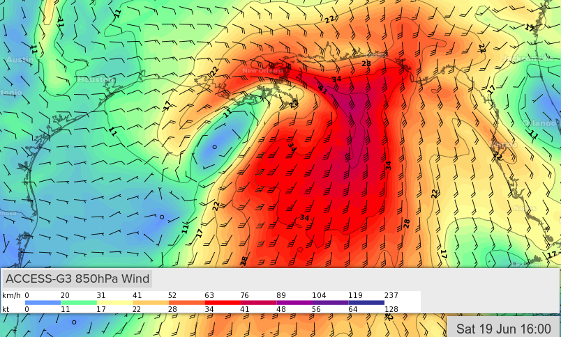
If I had a dollar for every time someone felt compelled to suggest "the NAM is not a reliable tool to use for tropical cyclones"  I bring it up however in light of this morning's satellite showing yet another vorticity center around 23N & 93W. All other global models have backed off developing a TD or reasonably closed low below 1006 mb. The 6Z NAM suddenly became more bullish suggesting a tight and deeper LLC to form around 24.5 & 90.5 during the day. While a good 2 degrees east of the present LLC vorticity as seen on Satellite, this NAM depiction is near this vorticity's latitude. Of course, the 12Z NAM is just now coming out and is just as quick to back off from it's more bullish 6Z forecast for late today LOL
  .
.
Point being, either the NHC is unflinchingly incorrect toward anticipating at least a TD (or sub-TD).... OR that nearly every global model is about to WHIFF at this latest "gyre induced area of vorticity" which might actually be the real deal, and not become upper level shear-hacked as well. Just sayin' that it doesn't take much for every model to flip in the event that they have an actual developing vortex to initiate. I think it should be fairly clear by late tonight whether we finally have a developing T.D. or an early season nothing burger. C'mon Aric, jump on the wagon Plenty of additional seats available (admission free).
. Point being, either the NHC is unflinchingly incorrect toward anticipating at least a TD (or sub-TD).... OR that nearly every global model is about to WHIFF at this latest "gyre induced area of vorticity" which might actually be the real deal, and not become upper level shear-hacked as well. Just sayin' that it doesn't take much for every model to flip in the event that they have an actual developing vortex to initiate. I think it should be fairly clear by late tonight whether we finally have a developing T.D. or an early season nothing burger. C'mon Aric, jump on the wagon
6 likes
Personal Forecast Disclaimer:
The posts in this forum are NOT official forecast and should not be used as such. They are just the opinion of the poster and may or may not be backed by sound meteorological data. They are NOT endorsed by any professional institution or storm2k.org. For official information, please refer to the NHC and NWS products.
The posts in this forum are NOT official forecast and should not be used as such. They are just the opinion of the poster and may or may not be backed by sound meteorological data. They are NOT endorsed by any professional institution or storm2k.org. For official information, please refer to the NHC and NWS products.
Re: ATL: INVEST 92L - Models
chaser1 wrote:If I had a dollar for every time someone felt compelled to suggest "the NAM is not a reliable tool to use for tropical cyclones"
Point being, either the NHC is unflinchingly incorrect toward anticipating at least a TD (or sub-TD).... OR that nearly every global model is about to WHIFF at this latest "gyre induced area of vorticity" which might actually be the real deal, and not become upper level shear-hacked as well. Just sayin' that it doesn't take much for every model to flip in the event that they have an actual developing vortex to initiate. I think it should be fairly clear by late tonight whether we finally have a developing T.D. or an early season nothing burger. C'mon Aric, jump on the wagon
Well the 18z nam is even more gung ho with a 989mb low, if that pans out tomorrow afternoon will be an interesting read here.
4 likes
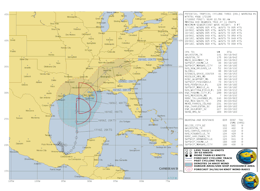
Re: ATL: THREE - Models
Eastern standard time.
https://postimg.cc/147gwqBy
https://postimg.cc/d7931kDP
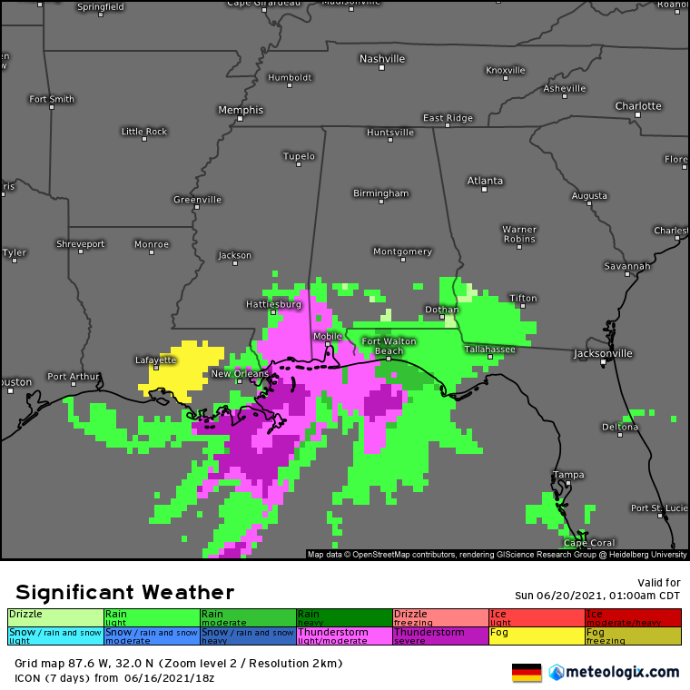
Winds are known to mix down. And the chance of a random tornado can't be ruled out on paper looking @ the above model.
https://postimg.cc/147gwqBy
https://postimg.cc/d7931kDP
Winds are known to mix down. And the chance of a random tornado can't be ruled out on paper looking @ the above model.
4 likes

Re: ATL: THREE - Models
^ word.
We're into that day to day and a half range for impact. Some of the mesoscale models are hinting that this is actually going to crank.
Here's the HRRR 00z out to 12 hours. Note the solid looking banding on the northeast side of the circulation.
https://www.tropicaltidbits.com/analysi ... 1800&fh=12
It's wanting to kick it at 16 hours, but the heaviest stuff is offshore.
https://www.tropicaltidbits.com/analysi ... 1800&fh=16
Looks like torrents of rain into coastal MS/AL/FL and some of SELA in slowly advancing bands coming in off the SE and ESE. Glad this one doesn't look to hang around any length of time.
The 18z RGEM really wants to sock coastal Mississippi and Alabama. What's odd is that it doesn't pick up on any of that as rainfall. Grain of salt there.
https://www.tropicaltidbits.com/analysi ... 1718&fh=32
4 likes
Re: ATL: THREE - Models
Depression-ish HRRR @ 28 (valid for 11pm tomorrow night). Landfall Terrebonne Parish with displaced feeder bands across the NC Gulf. Should be an active weather night tomorrow in coastal MS/Al per the HRRR. What it shows is certainly more of an issue for marine interests than us on land. But there probably will be some tidal flooding as well as flash flooding. HRRR hints around Jackson/Mobile counties to get the training bands.
https://www.tropicaltidbits.com/analysi ... 1800&fh=32
^^ edit to say sorry for the wrong link at first. That's 32 hours.
https://www.tropicaltidbits.com/analysi ... 1800&fh=32
^^ edit to say sorry for the wrong link at first. That's 32 hours.
0 likes
Re: ATL: THREE - Models
00z FV3 is rolling in and out to 14 hours. Almost looks like this will get better structure over land. I can't say if that will happen or if it's an omen for later stuff that comes up intensifying farther north. Looks like same target area, but the bands want to come in a little more from the south than building from the southeast (HRRR) to where the squalls roll in from the east as they progress north. We'll see where this model goes.
https://www.tropicaltidbits.com/analysi ... 1800&fh=14
NAM 3km is rolling now too. 13 hours, it's trying with maybe not enough Gulf left. You wouldn't want this scenario later in the season.
https://www.tropicaltidbits.com/analysi ... 1800&fh=13
It's a quick trip into MJO Phase 2.
https://www.tropicaltidbits.com/analysi ... 1800&fh=14
NAM 3km is rolling now too. 13 hours, it's trying with maybe not enough Gulf left. You wouldn't want this scenario later in the season.
https://www.tropicaltidbits.com/analysi ... 1800&fh=13
It's a quick trip into MJO Phase 2.
0 likes
Re: ATL: THREE - Models
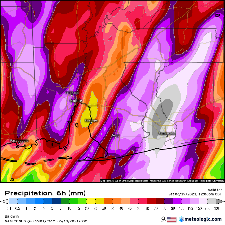
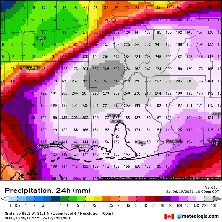
Decent rain rates there in the forecast for Pensacola. No matter what neck of the woods you come from, Internationally those numbers and shades are = to flash rapid flooding should it verify
https://postimg.cc/CnhgFqNZ
1 likes
Re: ATL: THREE - Models
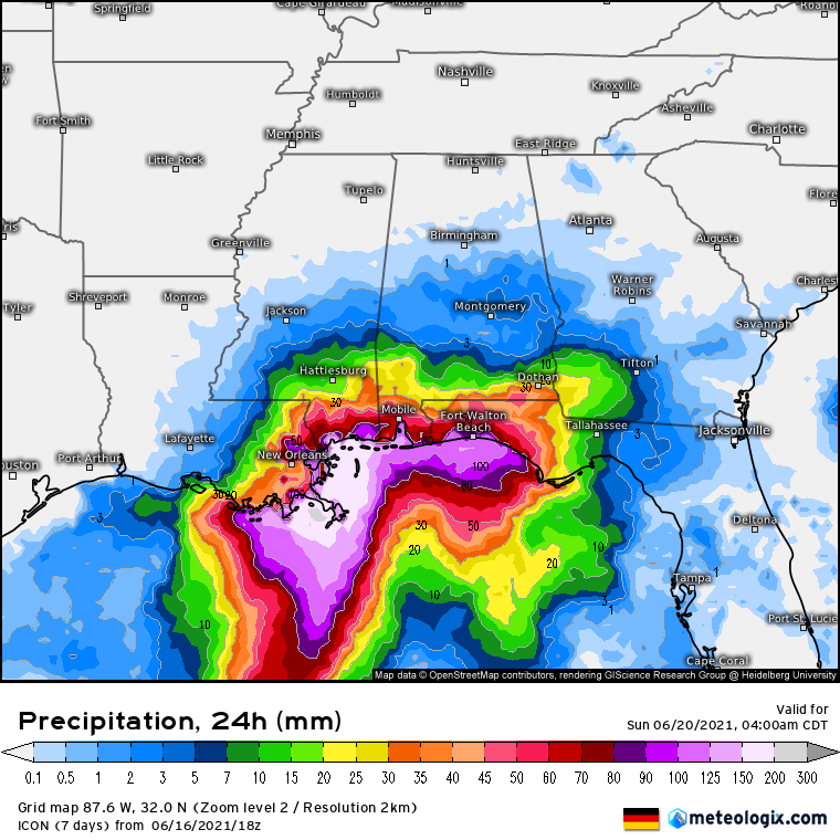
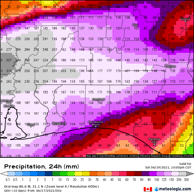
GFS brings the most rainfall to Plaquemines Parish, LA then all of coastal MS and into Mobile and Washington Counties.
https://www.tropicaltidbits.com/analysi ... 1800&fh=96
ICON still keeps most of the rain offshore but aims for the MS Coast which shouldn't be a surprise. Rainfall will be way more, so I'm not even posting it.
Canadian is similar to the GFS. Washington Co, AL just north of Mobile Co.
https://www.tropicaltidbits.com/analysi ... 1800&fh=42
RGEM's rainfall rates look more realistic if high. Foot or so across the MS/AL Gulf Coasts. I'd bet it's closer to this than the ICON.
https://www.tropicaltidbits.com/analysi ... 1800&fh=42
0 likes
-
Iceresistance

- Category 5
- Posts: 8915
- Age: 20
- Joined: Sat Oct 10, 2020 9:45 am
- Location: Tecumseh, OK/Norman, OK
Re: ATL: THREE - Models
My Summer School Teacher (I'm the helper for her), is planning to be at Dalphin Island, AL next week, she is planning to be there by Sunday, she is leaving Saturday Morning to Alabama. When is she going to expect tropical conditions on the way there?
0 likes
Bill 2015 & Beta 2020
Winter 2020-2021
All observations are in Tecumseh, OK unless otherwise noted.
Winter posts are focused mainly for Oklahoma & Texas.
Take any of my forecasts with a grain of salt, refer to the NWS, SPC, and NHC for official information
Never say Never with weather! Because ANYTHING is possible!
Winter 2020-2021
All observations are in Tecumseh, OK unless otherwise noted.
Winter posts are focused mainly for Oklahoma & Texas.
Take any of my forecasts with a grain of salt, refer to the NWS, SPC, and NHC for official information
Never say Never with weather! Because ANYTHING is possible!
Re: ATL: THREE - Models
Iceresistance wrote:My Summer School Teacher (I'm the helper for her), is planning to be at Dalphin Island, AL next week, she is planning to be there by Sunday, she is leaving Saturday Morning to Alabama. When is she going to expect tropical conditions on the way there?
Would depend on how she goes. Rain is already up to Lake Pontchartrain per the LIX radar site. Most of the rain should be there to the east and probably a lot of it will see it between now and tomorrow. They may or may not encounter tropical conditions but it won't likely be tropical storm conditions. I'm assuming that teacher likes to fish. That's what happens there. It's nice, but the water isn't usually blue on that side of the Bay due to influence from the MS River.
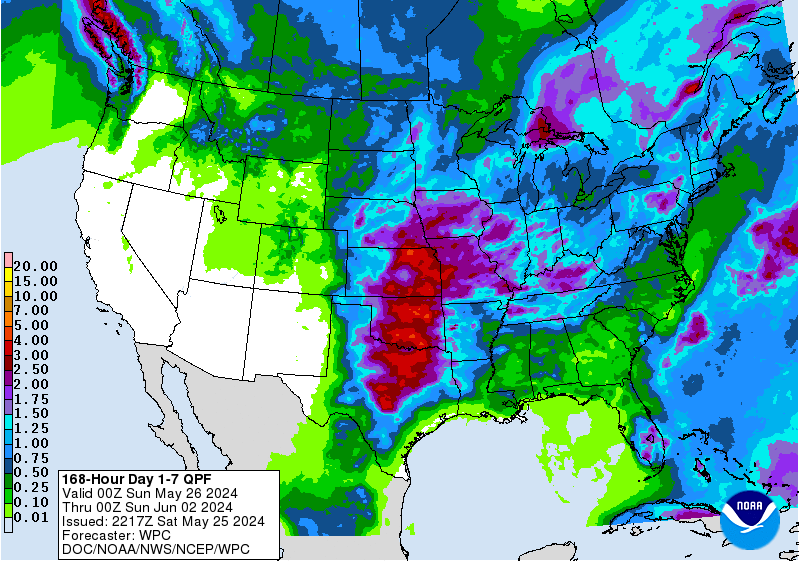
QPF
https://www.wpc.ncep.noaa.gov/qpf/p168i.gif?1624020169
0 likes
Who is online
Users browsing this forum: No registered users and 22 guests