EPAC: ENRIQUE - Remnants
Moderator: S2k Moderators
-
Sciencerocks
- Category 5

- Posts: 7286
- Age: 38
- Joined: Thu Jul 06, 2017 1:51 am
-
Yellow Evan

- Professional-Met

- Posts: 15952
- Age: 25
- Joined: Fri Jul 15, 2011 12:48 pm
- Location: Henderson, Nevada/Honolulu, HI
- Contact:
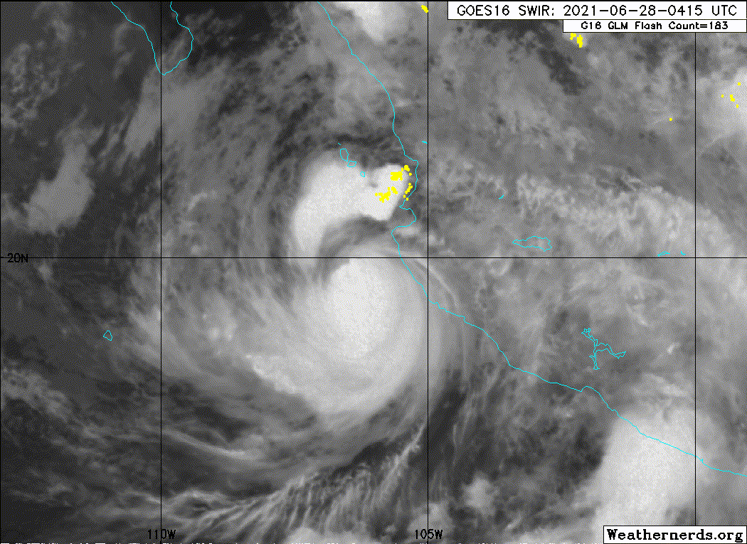
Re: EPAC: ENRIQUE - Hurricane
000
WTPZ45 KNHC 280835
TCDEP5
Hurricane Enrique Discussion Number 13
NWS National Hurricane Center Miami FL EP052021
300 AM MDT Mon Jun 28 2021
Enrique's cloud pattern has changed little in organization over the
past several hours. An eye is no longer apparent in geostationary
satellite images, but the central dense overcast is still
characterized by fairly cold cloud tops. The current intensity
for this advisory is held at 80 kt, which is close to the
latest Dvorak estimates from TAFB and SAB. A slow weakening trend
is expected to begin soon, as the cyclone starts to move into a
little less conducive environment. Faster weakening is likely to
commence in 24 to 48 hours due to decreasing oceanic heat content,
and entrainment of a more stable air mass. The official intensity
forecast is a blend of the corrected and simple consensus model
guidance and is similar to the previous NHC prediction.
Latest center fixes show that the hurricane's heading is beginning
to lean a little to the left and the initial motion is now
north-northwestward, or 340/5 kt. A weak ridge that is forecast to
develop over northwestern mainland Mexico should cause the cyclone
to turn toward the northwest during the next day or two. This
general motion should continue through 48-72 hours, however the
steering currents are likely to remain rather weak so Enrique is
expected to move quite slowly for the next few days. The
official track forecast is close to the latest corrected
consensus predictions, HCCA and the FSU Superensemble.
On the forecast track, Enrique is expected to pass near or over the
southern portion of the Baja California peninsula in 2-3 days. A
Tropical Storm Watch will likely be required for a portion of that
area later today.
Key Messages:
1. The outer rainbands of Enrique are likely to produce heavy rains
across a portion of western Mexico during the next couple of days,
which would likely cause life-threatening flash flooding and
mudslides.
2. The core of Enrique will continue to pass near the southwestern
coast of Mexico this morning and a Hurricane Warning is in effect
for a portion of that area. Tropical-storm-force winds are
expected to continue across the remainder of southwestern Mexico
within the warning areas through today. Hurricane conditions are
possible in the Hurricane Watch area today.
3. Swells generated by Enrique are expected to affect the
southwestern coast of Mexico during the next few days. These swells
could cause life-threatening surf and rip currents.
FORECAST POSITIONS AND MAX WINDS
INIT 28/0900Z 20.0N 106.3W 80 KT 90 MPH
12H 28/1800Z 20.6N 106.8W 75 KT 85 MPH
24H 29/0600Z 21.2N 107.3W 70 KT 80 MPH
36H 29/1800Z 21.9N 107.9W 60 KT 70 MPH
48H 30/0600Z 22.7N 108.7W 50 KT 60 MPH
60H 30/1800Z 23.6N 109.5W 40 KT 45 MPH...INLAND
72H 01/0600Z 24.5N 110.4W 30 KT 35 MPH...OVER WATER
96H 02/0600Z 25.5N 112.0W 20 KT 25 MPH...POST-TROP/INLAND
120H 03/0600Z...DISSIPATED
$$
Forecaster Pasch
0 likes
-
cycloneye

- Admin

- Posts: 139089
- Age: 67
- Joined: Thu Oct 10, 2002 10:54 am
- Location: San Juan, Puerto Rico
Re: EPAC: ENRIQUE - Hurricane
Hurricane Enrique Discussion Number 14
NWS National Hurricane Center Miami FL EP052021
900 AM MDT Mon Jun 28 2021
The convective structure of Enrique has eroded some this morning as
the hurricane appears to be feeling the effects of dry air
entrainment, both from downsloping to the northeast off the higher
terrain of Mexico and from stable air being entrained from the
northwest. This degradation in the northern portion of Enrique's
inner-core structure is also seen in an 0919 UTC AMSR2 microwave
pass. The latest subjective Dvorak intensity estimates were T4.5/77
kt from both TAFB and SAB, and the intensity for this advisory was
lowered to 75 kt in accordance with these estimates.
Enrique's motion appears to be gradually turning more toward the
left at 335/4 kt. Over the next few days, a weak low- to mid-level
ridge is expected to keep the storm on a similar northwest heading.
The latest track guidance is in relatively good agreement, though
there have been notable leftward shifts in the HWRF and HMON models.
The latest NHC forecast is a slightly farther left compared to the
previous one, close to both the TVCE and HCCA consensus aids.
Now that Enrique's inner core structure has become increasingly
ragged, weakening is expected to continue via dry-air entrainment as
the storm tracks along gradually decreasing oceanic heat content.
The latest NHC intensity forecast is a bit faster in its weakening
rate over the next 24-36 hours, but Enrique is still forecast to be
a tropical storm as it approaches the Baja California peninsula.
However, some uncertainty remains in the forecast intensity because
Enrique is forecast to track along a sharp sea-surface temperature
gradient, where a left shift in the track would likely result in
faster weakening rate while a right shift in the track may allow
Enrique to maintain its intensity longer.
Given the latest forecast, the government of Mexico has issued a
tropical storm watch from Cabo San Lucas to Los Barriles along
southern part of the Baja California Peninsula.
Key Messages:
1. The outer rainbands of Enrique are likely to produce heavy rains
across a portion of western Mexico during the next couple of days,
which could likely cause life-threatening flash flooding and
mudslides.
2. The core of Enrique is still near but just offshore the
southwestern coast of Mexico this morning and a Hurricane Warning is
in effect for a portion of that area. Tropical-storm-force winds
are expected to continue across the remainder of southwestern Mexico
within the warning areas through today. Hurricane conditions are
possible in the Hurricane Watch area today.
3. Swells generated by Enrique are expected to affect the
southwestern coast of Mexico during the next few days. These swells
could cause life-threatening surf and rip currents.
FORECAST POSITIONS AND MAX WINDS
INIT 28/1500Z 20.4N 106.7W 75 KT 85 MPH
12H 29/0000Z 20.9N 107.2W 70 KT 80 MPH
24H 29/1200Z 21.4N 107.7W 60 KT 70 MPH
36H 30/0000Z 22.2N 108.4W 50 KT 60 MPH
48H 30/1200Z 23.0N 109.3W 40 KT 45 MPH
60H 01/0000Z 23.8N 110.0W 30 KT 35 MPH...INLAND
72H 01/1200Z 24.5N 110.8W 25 KT 30 MPH...POST-TROP/INLAND
96H 02/1200Z 25.3N 112.0W 20 KT 25 MPH...POST-TROP/INLAND
120H 03/1200Z...DISSIPATED
$$
Forecaster Papin/Stewart
0 likes
Visit the Caribbean-Central America Weather Thread where you can find at first post web cams,radars
and observations from Caribbean basin members Click Here
and observations from Caribbean basin members Click Here
-
Sciencerocks
- Category 5
- Posts: 7286
- Age: 38
- Joined: Thu Jul 06, 2017 1:51 am
-
cycloneye
- Admin
- Posts: 139089
- Age: 67
- Joined: Thu Oct 10, 2002 10:54 am
- Location: San Juan, Puerto Rico
Re: EPAC: Enrique - Tropical Storm
Tropical Storm Enrique Discussion Number 15
NWS National Hurricane Center Miami FL EP052021
300 PM MDT Mon Jun 28 2021
This afternoon Enrique's satellite structure has rapidly
deteriorated, with the low-level circulation becoming exposed to the
north of a shrinking region of deep convection. Both TAFB and SAB
came in with T4.0/65 kt subjective Dvorak estimates this afternoon,
however the data T-numbers, which are less constrained than the
Current Intensity numbers, were lower. The latest objective UW-CIMSS
ADT estimates has also been rapidly dropping with the current value
at T3.0/45 kt. Since the satellite structure has continued to
degrade, Enrique has been downgraded to a tropical storm with a 60
kt intensity.
Enrique has continued to turn leftward through the course of the
day, with the estimated motion now at 315/5 kt. Over the next few
days, a weak low- to mid-level ridge is expected to maintain the
storm on a slow northwest heading. However, there has been a subtle
left and fast shift in the guidance this afternoon. The latest NHC
track forecast has shifted a bit west and is a bit faster in
accordance with the consensus aids, but is not as far west or quick
as the latest TVCE consensus.
Dry-air entrainment has done a number to the inner core of Enrique
today. As the storm continues to move northwestward towards lower
oceanic heat content and a drier and more stable environment,
weakening is expected to continue. However, the storm is still
forecasted to be a tropical storm as it approaches the southern tip
of Baja California where tropical storm watches remain in effect. By
72 h the low-level circulation could be further disrupted by the
terrain of Baja California and the latest NHC forecast expects
Enrique to degenerate into a remnant low by that time.
Key Messages:
1. The outer rainbands of Enrique are likely to produce heavy rains
across a portion of western Mexico during the next couple days,
which would likely cause life-threatening flash flooding and
mudslides.
2. The core of Enrique is moving away from southwestern coast of
Mexico this afternoon. Tropical-storm-force winds could still
occur over portions of southwestern Mexico within the warning areas
through tonight.
3. Swells generated by Enrique are expected to affect the
southwestern coast of Mexico during the next few days. These swells
could cause life-threatening surf and rip currents.
FORECAST POSITIONS AND MAX WINDS
INIT 28/2100Z 20.7N 107.3W 60 KT 70 MPH
12H 29/0600Z 21.4N 107.8W 50 KT 60 MPH
24H 29/1800Z 22.1N 108.5W 40 KT 45 MPH
36H 30/0600Z 22.8N 109.4W 35 KT 40 MPH
48H 30/1800Z 23.7N 110.3W 30 KT 35 MPH...INLAND
60H 01/0600Z 24.3N 111.1W 30 KT 35 MPH...INLAND
72H 01/1800Z 24.7N 111.9W 25 KT 30 MPH...POST-TROP/INLAND
96H 02/1800Z...DISSIPATED
$$
Forecaster Papin/Stewart
0 likes
Visit the Caribbean-Central America Weather Thread where you can find at first post web cams,radars
and observations from Caribbean basin members Click Here
and observations from Caribbean basin members Click Here
-
Sciencerocks
- Category 5
- Posts: 7286
- Age: 38
- Joined: Thu Jul 06, 2017 1:51 am
-
cycloneye
- Admin
- Posts: 139089
- Age: 67
- Joined: Thu Oct 10, 2002 10:54 am
- Location: San Juan, Puerto Rico
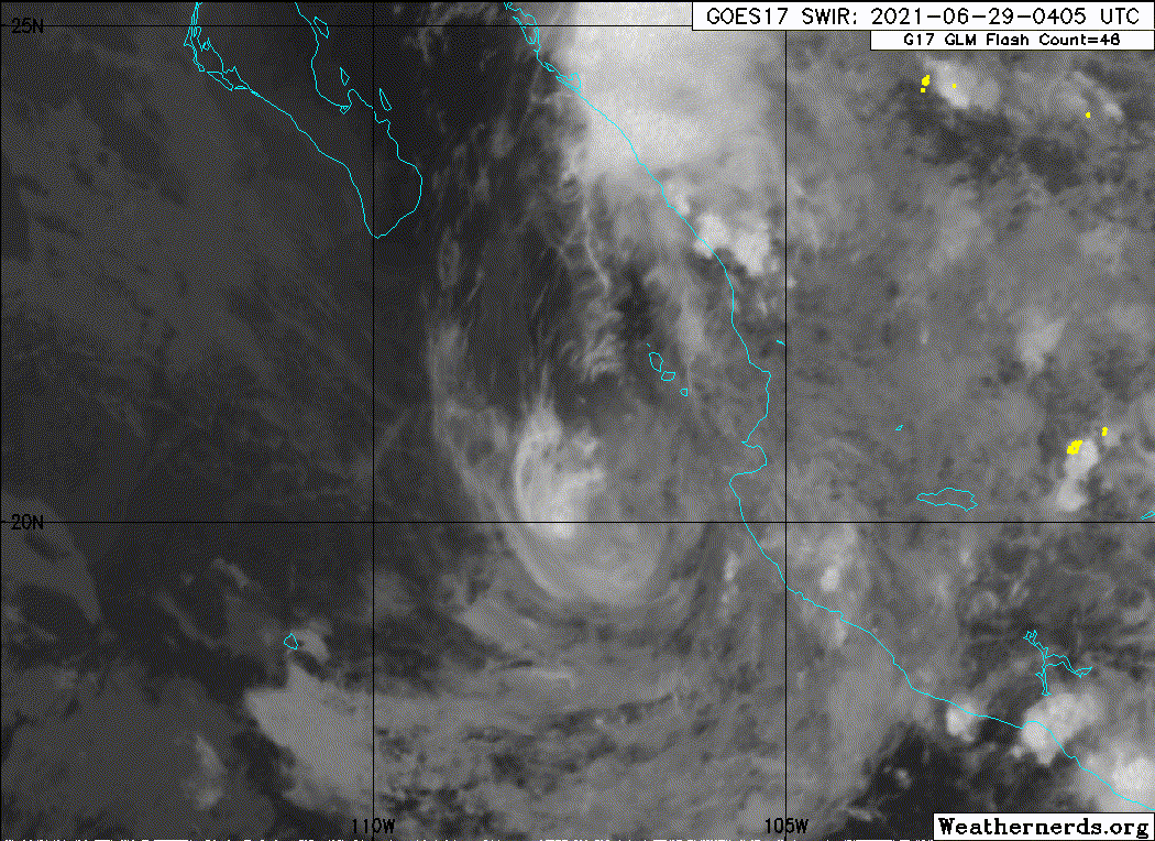
Re: EPAC: ENRIQUE - Tropical Storm
Tropical Storm Enrique Discussion Number 17
NWS National Hurricane Center Miami FL EP052021
300 AM MDT Tue Jun 29 2021
Enrique has lost most of its associated deep convection, likely due
to the entrainment of drier and more stable air. Upwelling of
cooler waters beneath the slow-moving circulation may also be a
contributing factor. Based on data from a couple of earlier
scatterometer overpasses, the intensity was reduced to 45 kt.
Given the dearth of convection, this may be a generous estimate for
the current intensity of the storm. Since the thermodynamic
environment is not expected to become any more conducive, weakening
is forecast. The official intensity forecast is similar to the
previous one and close to the model consensus. It should be noted
that Enrique could weaken more rapidly than expected if significant
deep convection does not redevelop within the circulation soon.
Therefore, the intensity forecast for this system is highly
uncertain.
The center has become very difficult to locate and the fixes
have considerable spread, making the initial position and motion
estimates quite uncertain. Based heavily on continuity, the
initial motion estimate is a continued northwestward track, or 325/5
kt. The flow to the west of a mid-level ridge over northwestern
Mexico should steer Enrique generally northwestward for the next
couple of days, taking the system near or over the southern Baja
California Peninsula.
Given the uncertainty as to whether Enrique will maintain tropical
storm intensity by the time it moves near or over southern Baja, it
is decided to continue with a Tropical Storm Watch for that area,
and not upgrade it to a warning at this time.
Key Messages:
1. The outer rainbands of Enrique are likely to produce heavy rains
across a portion of western Mexico and the southern Baja Peninsula
during the next couple days. The additional rainfall over the
mainland of Mexico will continue to pose a threat of flash flooding
and mudslides.
2. Tropical-storm-force winds are possible over portions of the
southern portion of the Baja California Peninsula beginning tonight,
and a Tropical Storm Watch is in effect for that area.
3. Swells generated by Enrique will affect the southwestern coast
of Mexico during the next day or two, and will spread northward
along portions of the coast of southern Baja California Peninsula
and Gulf of California during the next couple of days. These swells
are likely to cause life-threatening surf and rip current
conditions. Please consult products from your local weather office.
FORECAST POSITIONS AND MAX WINDS
INIT 29/0900Z 21.6N 107.6W 45 KT 50 MPH
12H 29/1800Z 22.5N 108.3W 40 KT 45 MPH
24H 30/0600Z 23.5N 109.4W 35 KT 40 MPH
36H 30/1800Z 24.5N 110.5W 30 KT 35 MPH
48H 01/0600Z 25.2N 111.7W 25 KT 30 MPH...POST-TROP/INLAND
60H 01/1800Z 25.5N 112.5W 20 KT 25 MPH...POST-TROP/REMNT LOW
72H 02/0600Z...DISSIPATED
$$
Forecaster Pasch
0 likes
Visit the Caribbean-Central America Weather Thread where you can find at first post web cams,radars
and observations from Caribbean basin members Click Here
and observations from Caribbean basin members Click Here
-
Sciencerocks
- Category 5
- Posts: 7286
- Age: 38
- Joined: Thu Jul 06, 2017 1:51 am

-
cycloneye
- Admin
- Posts: 139089
- Age: 67
- Joined: Thu Oct 10, 2002 10:54 am
- Location: San Juan, Puerto Rico
Re: EPAC: ENRIQUE - Tropical Storm
Tropical Storm Enrique Discussion Number 18
NWS National Hurricane Center Miami FL EP052021
900 AM MDT Tue Jun 29 2021
Enrique remains devoid of any deep convection near its center this
morning. The system appears to have entrained drier, more stable air
into its core, which has suppressed all thunderstorm activity.
Overnight scatterometer data revealed winds to 40 kt in the eastern
semicircle, but the system has likely weakened since then given its
lack of convection. The initial intensity is lowered to 35 kt with
this advisory, which is consistent with an objective SATCON estimate
and TAFB subjective Dvorak classification.
Passive microwave data and proxy visible satellite imagery show that
the low-level center of Enrique is exposed and slightly northeast of
previous estimates. The estimated initial motion is an uncertain
335/7 kt. The system is expected to gradually turn toward the
northwest and approach the southern Baja California peninsula
tonight into Wednesday. The official NHC forecast has been adjusted
slightly right-of-track from the previous advisory to account for
the center relocation, and generally follows the multi-model
consensus.
Enrique remains in an environment with fairly low oceanic heat
content and some drier mid-level air, and all the reliable intensity
models suggest the cyclone will continue weakening. Therefore, the
NHC intensity forecast shows Enrique becoming a tropical depression
by tomorrow. However, if the system fails to generate any organized
convection near its center soon, it could degenerate into a
post-tropical remnant low later today or tonight.
Key Messages:
1. The outer rainbands of Enrique are likely to produce heavy rains
across a portion of western Mexico and the southern Baja Peninsula
during the next couple of days. The additional rainfall over the
mainland of Mexico will continue to pose a threat of flash flooding
and mudslides.
2. Tropical-storm-force winds are possible over southern portions of
the Baja California Peninsula beginning tonight, and a Tropical
Storm Watch is in effect for that area.
3. Swells generated by Enrique will affect the southwestern coast of
Mexico, and portions of the Gulf of California and the coast of the
southern Baja California Peninsula during the next couple of days.
These swells are likely to cause life-threatening surf and rip
current conditions. Please consult products from your local weather
office.
FORECAST POSITIONS AND MAX WINDS
INIT 29/1500Z 22.5N 107.6W 35 KT 40 MPH
12H 30/0000Z 23.3N 108.5W 35 KT 40 MPH
24H 30/1200Z 24.2N 109.6W 30 KT 35 MPH
36H 01/0000Z 25.1N 110.9W 25 KT 30 MPH...NEAR THE COAST
48H 01/1200Z 25.8N 111.9W 20 KT 25 MPH...POST-TROP/INLAND
60H 02/0000Z...DISSIPATED
$$
Forecaster Reinhart/Beven
0 likes
Visit the Caribbean-Central America Weather Thread where you can find at first post web cams,radars
and observations from Caribbean basin members Click Here
and observations from Caribbean basin members Click Here
-
galaxy401

- Category 5
- Posts: 2299
- Age: 28
- Joined: Sat Aug 25, 2012 9:04 pm
- Location: Casa Grande, Arizona
Re: EPAC: ENRIQUE - Tropical Storm
Should be post-tropical for the next advisory. It's been devoid of convection for awhile now.
Granted NOAA is undergoing maintenance right now so satellite imagery is delayed.
Granted NOAA is undergoing maintenance right now so satellite imagery is delayed.
1 likes
Got my eyes on moving right into Hurricane Alley: Florida.
-
Sciencerocks
- Category 5
- Posts: 7286
- Age: 38
- Joined: Thu Jul 06, 2017 1:51 am
-
Yellow Evan
- Professional-Met
- Posts: 15952
- Age: 25
- Joined: Fri Jul 15, 2011 12:48 pm
- Location: Henderson, Nevada/Honolulu, HI
- Contact:
Re: EPAC: ENRIQUE - Tropical Storm
Still qualifies as a tropical cyclone given convection has re-fired, and I’d expect such bursts to continue given its not under horrible conditions.
0 likes
-
Astromanía
- Category 2

- Posts: 737
- Age: 25
- Joined: Sat Aug 25, 2018 10:34 pm
- Location: Monterrey, N.L, México
Re: EPAC: ENRIQUE - Tropical Storm
Worst rainfall accumulations by Enrique from june 26th to june 28th,
Melchor Ocampo L.C, Michoacan: 542mm 21 in
Higuera Blanca, Jalisco: 359.7mm 14 in
Radar, Colima 321.5mm 12 in
Source: https://smn.conagua.gob.mx/es/pronosticos/pronosticossubmenu/reporte-de-lluvia-acumulada-de-tres-dias
Melchor Ocampo L.C, Michoacan: 542mm 21 in
Higuera Blanca, Jalisco: 359.7mm 14 in
Radar, Colima 321.5mm 12 in
Source: https://smn.conagua.gob.mx/es/pronosticos/pronosticossubmenu/reporte-de-lluvia-acumulada-de-tres-dias
0 likes
-
cycloneye
- Admin
- Posts: 139089
- Age: 67
- Joined: Thu Oct 10, 2002 10:54 am
- Location: San Juan, Puerto Rico
Re: EPAC: ENRIQUE - Tropical Storm
Tropical Storm Enrique Discussion Number 20
NWS National Hurricane Center Miami FL EP052021
900 PM MDT Tue Jun 29 2021
After spending nearly a day mostly devoid of deep, organized
convection, Enrique was able to re-develop a small convective burst,
beginning just after the previous advisory. While not particularly
well-organized, the convective depth is fairly cold, between -65 to
-70 C, and has been persistent enough near the low-level circulation
center that it justifies maintaining advisories at this time. The
initial intensity remains estimated at 35 kt in accordance with the
earlier scatterometer data when Enrique still lacked convection,
though this estimate could be generous given the lower subjective
satellite estimates provided by SAB and TAFB.
The cyclone continues to move to the northwest, but appears to have
sped up a bit, with an estimated motion of 315/10 kt. This general
heading should continue over the next 12 hours as the small storm
continues to track further into the Gulf of California. Thereafter,
the system is forecast to take a slight leftward bend, which could
bring the tropical cyclone near the coast of Baja California by 24
hours. The most recent forecast track is very similar to the
previous advisory, with the exception of a slight leftward shift
after 24 hours, blending the reliable HCCA and TVCE consensus aids.
Despite the recent small convective burst just east of Enrique's
center, which was well anticipated by the ECMWF and HWRF, the
cyclone is expected to spin down further, especially as its small
circulation begins to interact with the higher terrain of Baja
California. Enrique is expected to weaken into a tropical depression
in the next 12 hours, with dissipation likely by 48 hours after
moving over land.
Key Messages:
1. The outer rainbands of Enrique may produce heavy rains across a
portion of western Mexico and the southern Baja Peninsula during the
next couple days. This rainfall over the mainland of Mexico will
continue to pose a threat of flash flooding and mudslides.
2. Swells generated by Enrique will affect the southwestern coast of
Mexico, and portions of the Gulf of California and the coast of the
southern Baja California Peninsula during the next day or so. These
swells are likely to cause life-threatening surf and rip current
conditions. Please consult products from your local weather office.
FORECAST POSITIONS AND MAX WINDS
INIT 30/0300Z 23.8N 109.1W 35 KT 40 MPH
12H 30/1200Z 24.5N 109.8W 30 KT 35 MPH
24H 01/0000Z 25.2N 110.8W 25 KT 30 MPH...NEAR THE COAST
36H 01/1200Z 25.5N 111.7W 20 KT 25 MPH...POST-TROP/INLAND
48H 02/0000Z...DISSIPATED
$$
Forecaster Papin/Cangialosi
0 likes
Visit the Caribbean-Central America Weather Thread where you can find at first post web cams,radars
and observations from Caribbean basin members Click Here
and observations from Caribbean basin members Click Here
-
Sciencerocks
- Category 5
- Posts: 7286
- Age: 38
- Joined: Thu Jul 06, 2017 1:51 am
-
cycloneye
- Admin
- Posts: 139089
- Age: 67
- Joined: Thu Oct 10, 2002 10:54 am
- Location: San Juan, Puerto Rico
Re: EPAC: ENRIQUE - Tropical Storm
Tropical Storm Enrique Discussion Number 21
NWS National Hurricane Center Miami FL EP052021
300 AM MDT Wed Jun 30 2021
Enrique is producing a small area of deep convection to the south
of the estimated center. This convective area has expanded a bit
over the past few hours. On this basis, the cyclone is maintained
as a 35-kt tropical storm for this advisory which is a little above
the most recent subjective and objective Dvorak estimates. Enrique
should weaken to a tropical depression today as it interacts with
the land mass of the southern Baja California Peninsula. The
official intensity forecast is on the high side of the objective
guidance, and similar to the previous NHC prediction. Enrique
should become a remnant low over the Baja peninsula and dissipate in
36-48 hours if not sooner, if the global models are correct.
Although the center is not easy to track on infrared imagery, my
best estimate of initial motion is northwestward, or 315/8 kt.
This is not inconsistent with imagery from the Cabo San Lucas radar
provided by the Meteorological Service of Mexico. A weak ridge to
the northeast and north of the cyclone should result in a
northwestward to west-northwestward track until dissipation. The
official track forecast is on top of the latest HFIP corrected
consensus solution.
Key Messages:
1. The outer rainbands of Enrique may produce heavy rains across
portions of northwestern Mexico and the southern Baja Peninsula
during the next couple days, which will continue to pose a threat of
flash flooding and mudslides.
2. Swells generated by Enrique will affect the southwestern coast of
Mexico, and portions of the Gulf of California and the coast of the
southern Baja California Peninsula during the next day or so. These
swells are likely to cause life-threatening surf and rip current
conditions. Please consult products from your local weather office.
FORECAST POSITIONS AND MAX WINDS
INIT 30/0900Z 24.2N 109.6W 35 KT 40 MPH
12H 30/1800Z 24.8N 110.3W 30 KT 35 MPH
24H 01/0600Z 25.3N 111.2W 25 KT 30 MPH...INLAND
36H 01/1800Z 25.8N 112.1W 20 KT 25 MPH...POST-TROP/INLAND
48H 02/0600Z...DISSIPATED
$$
Forecaster Pasch
0 likes
Visit the Caribbean-Central America Weather Thread where you can find at first post web cams,radars
and observations from Caribbean basin members Click Here
and observations from Caribbean basin members Click Here
-
Yellow Evan
- Professional-Met
- Posts: 15952
- Age: 25
- Joined: Fri Jul 15, 2011 12:48 pm
- Location: Henderson, Nevada/Honolulu, HI
- Contact:
Re: EPAC: ENRIQUE - Tropical Storm
843
WTPZ45 KNHC 300835
TCDEP5
Tropical Storm Enrique Discussion Number 21
NWS National Hurricane Center Miami FL EP052021
300 AM MDT Wed Jun 30 2021
Enrique is producing a small area of deep convection to the south
of the estimated center. This convective area has expanded a bit
over the past few hours. On this basis, the cyclone is maintained
as a 35-kt tropical storm for this advisory which is a little above
the most recent subjective and objective Dvorak estimates. Enrique
should weaken to a tropical depression today as it interacts with
the land mass of the southern Baja California Peninsula. The
official intensity forecast is on the high side of the objective
guidance, and similar to the previous NHC prediction. Enrique
should become a remnant low over the Baja peninsula and dissipate in
36-48 hours if not sooner, if the global models are correct.
Although the center is not easy to track on infrared imagery, my
best estimate of initial motion is northwestward, or 315/8 kt.
This is not inconsistent with imagery from the Cabo San Lucas radar
provided by the Meteorological Service of Mexico. A weak ridge to
the northeast and north of the cyclone should result in a
northwestward to west-northwestward track until dissipation. The
official track forecast is on top of the latest HFIP corrected
consensus solution.
Key Messages:
1. The outer rainbands of Enrique may produce heavy rains across
portions of northwestern Mexico and the southern Baja Peninsula
during the next couple days, which will continue to pose a threat of
flash flooding and mudslides.
2. Swells generated by Enrique will affect the southwestern coast of
Mexico, and portions of the Gulf of California and the coast of the
southern Baja California Peninsula during the next day or so. These
swells are likely to cause life-threatening surf and rip current
conditions. Please consult products from your local weather office.
FORECAST POSITIONS AND MAX WINDS
INIT 30/0900Z 24.2N 109.6W 35 KT 40 MPH
12H 30/1800Z 24.8N 110.3W 30 KT 35 MPH
24H 01/0600Z 25.3N 111.2W 25 KT 30 MPH...INLAND
36H 01/1800Z 25.8N 112.1W 20 KT 25 MPH...POST-TROP/INLAND
48H 02/0600Z...DISSIPATED
$$
Forecaster Pasch
0 likes
-
cycloneye
- Admin
- Posts: 139089
- Age: 67
- Joined: Thu Oct 10, 2002 10:54 am
- Location: San Juan, Puerto Rico
Re: EPAC: ENRIQUE - Tropical Depression
Tropical Depression Enrique Discussion Number 22
NWS National Hurricane Center Miami FL EP052021
900 AM MDT Wed Jun 30 2021
After a brief burst of convection near its center overnight, the
satellite presentation of Enrique has degraded this morning.
Infrared cloud top temperatures have rapidly warmed near the
estimated center position, and the only active convection at this
time is occurring over the Baja California Peninsula. Overnight
satellite-derived wind data supported winds of 25 to 30 kt in the
northeast quadrant of the cyclone, and satellite trends suggest
Enrique has weakened since then. Additionally, TAFB gave the system
a T2.0 subjective Dvorak classification. Therefore, the initial
intensity is lowered to 30 kt this morning, which downgrades Enrique
to a tropical depression.
Enrique is currently moving northwestward, although it is expected
to turn slightly more west-northwestward later today between a weak
ridge to its northeast and a low- to mid-level low pressure system
well offshore. The track guidance remains in good agreement, and the
official NHC forecast lies close to the multi-model consensus.
Increasing vertical wind shear and drier mid-level air in the
surrounding environment, as well as increasing land interaction,
should support continued weakening during the next day or so. As
expected, simulated satellite imagery from the GFS and ECMWF do not
indicate much potential for additional convective development before
the system moves inland tonight. Therefore, Enrique is forecast to
become a remnant low over Baja California Sur by Thursday and
dissipate shortly thereafter.
Key Messages:
1. Heavy rains associated with Enrique are possible across southern
portions of Baja California Sur. This will pose a threat of flash
flooding and mudslides.
2. Swells generated by Enrique will affect portions of the western
coast of Mexico and the coast of Baja California Sur during the
next day or so. These swells are likely to cause life-threatening
surf and rip current conditions. Please consult products from your
local weather office.
FORECAST POSITIONS AND MAX WINDS
INIT 30/1500Z 24.6N 110.0W 30 KT 35 MPH
12H 01/0000Z 25.0N 110.8W 25 KT 30 MPH...INLAND
24H 01/1200Z 25.4N 111.7W 20 KT 25 MPH...POST-TROP/INLAND
36H 02/0000Z...DISSIPATED
$$
Forecaster Reinhart/Beven
0 likes
Visit the Caribbean-Central America Weather Thread where you can find at first post web cams,radars
and observations from Caribbean basin members Click Here
and observations from Caribbean basin members Click Here
-
Sciencerocks
- Category 5
- Posts: 7286
- Age: 38
- Joined: Thu Jul 06, 2017 1:51 am
-
Yellow Evan
- Professional-Met
- Posts: 15952
- Age: 25
- Joined: Fri Jul 15, 2011 12:48 pm
- Location: Henderson, Nevada/Honolulu, HI
- Contact:
Who is online
Users browsing this forum: No registered users and 74 guests