EPAC: ENRIQUE - Remnants

Moderator: S2k Moderators

Message
Author
User avatar
Yellow Evan
Professional-Met
Professional-Met
Posts: 15954
Age: 25
Joined: Fri Jul 15, 2011 12:48 pm
Location: Henderson, Nevada/Honolulu, HI
Contact:

Re: EPAC: ENRIQUE - Hurricane

#161 Postby Yellow Evan » Sun Jun 27, 2021 2:01 am

TXPZ24 KNES 270620
TCSENP

A. 05E (ENRIQUE)

B. 27/0530Z

C. 17.3N

D. 105.9W

E. THREE/GOES-W

F. T4.0/4.5

G. IR/EIR/SWIR

H. REMARKS...A LLCC THAT IS EMBEDDED WITHIN DG OVERCAST RESULTS IN A
DT OF 4.0. THE MET IS 4.0 BASED ON A SLOWLY DEVELOPING TREND IN APPARENT
INTENSITY OVER THE PAST 24 HOURS. THE PT IS 4.0. THE FT IS BASED ON THE
MET DUE TO UNCERTAINTY IN EXACT CENTER LOCATION.

I. ADDL POSITIONS

NIL


...HOSLEY
0 likes   

User avatar
galaxy401
Category 5
Category 5
Posts: 2299
Age: 28
Joined: Sat Aug 25, 2012 9:04 pm
Location: Casa Grande, Arizona

Re: EPAC: ENRIQUE - Hurricane

#162 Postby galaxy401 » Sun Jun 27, 2021 2:07 am

Enrique looks stationary to me. It's going to be upwelling cooler water soon if it doesn't get moving.
1 likes   
Got my eyes on moving right into Hurricane Alley: Florida.

User avatar
Kingarabian
S2K Supporter
S2K Supporter
Posts: 15437
Joined: Sat Aug 08, 2009 3:06 am
Location: Honolulu, Hawaii

Re: EPAC: ENRIQUE - Hurricane

#163 Postby Kingarabian » Sun Jun 27, 2021 2:23 am

UW - CIMSS
ADVANCED DVORAK TECHNIQUE
ADT-Version 9.0
Tropical Cyclone Intensity Algorithm

----- Current Analysis -----
Date : 27 JUN 2021 Time : 065023 UTC
Lat : 17:34:47 N Lon : 105:58:07 W


CI# /Pressure/ Vmax
4.1 / 980.2mb/ 67.4kt


Final T# Adj T# Raw T#
4.1 5.0 5.0
0 likes   
RIP Kobe Bryant

User avatar
Kingarabian
S2K Supporter
S2K Supporter
Posts: 15437
Joined: Sat Aug 08, 2009 3:06 am
Location: Honolulu, Hawaii

Re: EPAC: ENRIQUE - Hurricane

#164 Postby Kingarabian » Sun Jun 27, 2021 2:30 am

Either trying to clear out a large eye or gulping more dry air. 50/50

Image
0 likes   
RIP Kobe Bryant

User avatar
Kingarabian
S2K Supporter
S2K Supporter
Posts: 15437
Joined: Sat Aug 08, 2009 3:06 am
Location: Honolulu, Hawaii

Re: EPAC: ENRIQUE - Hurricane

#165 Postby Kingarabian » Sun Jun 27, 2021 2:51 am

00z HWRF peaks it near 85kts/100mph.

00z HMON makes this a borderline major hurricane.
Image
0 likes   
RIP Kobe Bryant

User avatar
Kingarabian
S2K Supporter
S2K Supporter
Posts: 15437
Joined: Sat Aug 08, 2009 3:06 am
Location: Honolulu, Hawaii

Re: EPAC: ENRIQUE - Hurricane

#166 Postby Kingarabian » Sun Jun 27, 2021 4:38 am

Eye feature getting more prevalent on IR:
Image
Image

Current Intensity Analysis


UW - CIMSS
ADVANCED DVORAK TECHNIQUE
ADT-Version 9.0
Tropical Cyclone Intensity Algorithm

----- Current Analysis -----
Date : 27 JUN 2021 Time : 092023 UTC
Lat : 17:27:00 N Lon : 105:43:12 W


CI# /Pressure/ Vmax
4.1 / 980.3mb/ 67.4kt


Final T# Adj T# Raw T#
3.9 4.5 5.4
Last edited by Kingarabian on Sun Jun 27, 2021 4:55 am, edited 1 time in total.
4 likes   
RIP Kobe Bryant

User avatar
Ubuntwo
Category 5
Category 5
Posts: 1089
Age: 30
Joined: Thu Oct 05, 2017 10:41 pm

Re: EPAC: ENRIQUE - Hurricane

#167 Postby Ubuntwo » Sun Jun 27, 2021 4:41 am

Image
Enrique's small eye is starting to peek through as wrapping convective bursts drive core subsidence. Does Enrique have the time to properly clear out its eye before the environment catches up? The HWRF sure seems to think so.
5 likes   
Kendall -> SLO -> PBC

Memorable Storms: Katrina (for its Florida landfall...) Wilma Matthew Irma

User avatar
Kingarabian
S2K Supporter
S2K Supporter
Posts: 15437
Joined: Sat Aug 08, 2009 3:06 am
Location: Honolulu, Hawaii

Re: EPAC: ENRIQUE - Hurricane

#168 Postby Kingarabian » Sun Jun 27, 2021 5:37 am

Latest AMSR2 pass shows concentric eyewalls... Looks like it was attempting an ERC 2 hours ago:
Image

Excellent inner structure regardless.
Image

Considering that ERC's mainly happen with Cat.3+ canes while also considering dry air is probably playing a role here, suggests this was/is at least a Cat.2 hurricane in the past 6 hours.
0 likes   
RIP Kobe Bryant

User avatar
Kingarabian
S2K Supporter
S2K Supporter
Posts: 15437
Joined: Sat Aug 08, 2009 3:06 am
Location: Honolulu, Hawaii

Re: EPAC: ENRIQUE - Hurricane

#169 Postby Kingarabian » Sun Jun 27, 2021 5:48 am

06z HMON now making this a bonafide major hurricane:
Image

06z HWRF peaks it @ 966mb/90kts. But its IR presentation resembles a mature major hurricane.
Image
0 likes   
RIP Kobe Bryant

User avatar
Yellow Evan
Professional-Met
Professional-Met
Posts: 15954
Age: 25
Joined: Fri Jul 15, 2011 12:48 pm
Location: Henderson, Nevada/Honolulu, HI
Contact:

Re: EPAC: ENRIQUE - Hurricane

#170 Postby Yellow Evan » Sun Jun 27, 2021 6:25 am

This storm can not handle the dry air intrusions an ERC would bring whatsoever. With that said, that’s not an ERC and more likely a dry air intrusion.
Last edited by Yellow Evan on Sun Jun 27, 2021 6:27 am, edited 1 time in total.
2 likes   

User avatar
Yellow Evan
Professional-Met
Professional-Met
Posts: 15954
Age: 25
Joined: Fri Jul 15, 2011 12:48 pm
Location: Henderson, Nevada/Honolulu, HI
Contact:

Re: EPAC: ENRIQUE - Hurricane

#171 Postby Yellow Evan » Sun Jun 27, 2021 6:26 am

000
WTPZ45 KNHC 270841
TCDEP5

Hurricane Enrique Discussion Number 9
NWS National Hurricane Center Miami FL EP052021
300 AM MDT Sun Jun 27 2021

The central dense overcast of the hurricane has not expanded much
over the past several hours, and the eye is not apparent on
geostationary satellite images. However, Enrique has well-defined
convective banding features over most of its circulation. Taking a
blend of the latest Dvorak intensity estimates from TAFB and SAB
gives a current intensity estimate of 80 kt. A little more
strengthening could occur today, as reflected in the official
forecast. In 24 to 48 hours, cooler sea surface temperatures and
decreasing oceanic heat content should cause a weakening trend to
commence. Later in the forecast period, the cyclone should be
entraining a drier and more stable air mass near the southern Baja
California peninsula, which should also contribute to the
weakening process. The official intensity forecast is similar to
the previous one and close to the HFIP Corrected Consensus and FSU
Superensemble predictions.

Enrique has moved quite slowly overnight and the initial motion
estimate is north-northwestward, or 330/3 kt. Steering currents
are expected to remain rather weak over the next few days. The
system is expected to move on a north-northwestward to
northwestward heading, in the general direction of a weak mid-level
trough over extreme northwestern Mexico, for the next 2-3 days.
Later in the forecast period, the weakening cyclone's track should
gradually bend to the left under the influence of the
lower-tropospheric environmental flow. The official track forecast
is a blend of the latest GFS and ECMWF solutions, and not too
different from the previous NHC track.


Key Messages:

1. The outer rainbands of Enrique are likely to produce heavy rains
across a portion of southwestern Mexico during the next couple
of days, which would likely cause life-threatening flash flooding
and mudslides.

2. Tropical-storm-force winds are expected to continue across
portions of southwestern Mexico through early Monday. Although the
core of Enrique is still forecast to remain just offshore, any
deviation to the right of the forecast track or expansion of the
wind field could bring even stronger winds onshore over a portion
of the southwestern coast of Mexico. Therefore, a Hurricane Watch
is in effect for a portion of that area.

3. Swells generated by Enrique are expected to affect the
southwestern coast of Mexico during the next few days. These swells
could cause life-threatening surf and rip currents.


FORECAST POSITIONS AND MAX WINDS

INIT 27/0900Z 17.6N 106.0W 80 KT 90 MPH
12H 27/1800Z 18.5N 106.1W 85 KT 100 MPH
24H 28/0600Z 19.4N 106.6W 80 KT 90 MPH
36H 28/1800Z 20.1N 107.2W 70 KT 80 MPH
48H 29/0600Z 20.7N 107.7W 65 KT 75 MPH
60H 29/1800Z 21.3N 108.2W 55 KT 65 MPH
72H 30/0600Z 22.1N 109.0W 45 KT 50 MPH
96H 01/0600Z 23.5N 110.5W 30 KT 35 MPH
120H 02/0600Z 24.7N 112.0W 25 KT 30 MPH...POST-TROP/REMNT LOW

$$
Forecaster Pasch
0 likes   

User avatar
Kingarabian
S2K Supporter
S2K Supporter
Posts: 15437
Joined: Sat Aug 08, 2009 3:06 am
Location: Honolulu, Hawaii

Re: EPAC: ENRIQUE - Hurricane

#172 Postby Kingarabian » Sun Jun 27, 2021 6:41 am

Yellow Evan wrote:This storm can not handle the dry air intrusions an ERC would bring whatsoever. With that said, that’s not an ERC and more likely a dry air intrusion.

Its been having dry air intrusions for the past 24 hours. Its MW presentation has consistently resembled this SSMIS F-18 pass taken 12 hours ago:
Image

This recent AMSR2 pass, is differently clearly depicting a ERC. Two seperated convectively deep eyewalls and a moat which is very similar to MW imagery found in ERC case studies.
Image
3 likes   
RIP Kobe Bryant

User avatar
cycloneye
Admin
Admin
Posts: 139142
Age: 67
Joined: Thu Oct 10, 2002 10:54 am
Location: San Juan, Puerto Rico

Re: EPAC: ENRIQUE - Hurricane

#173 Postby cycloneye » Sun Jun 27, 2021 7:40 am

BULLETIN
Hurricane Enrique Intermediate Advisory Number 9A
NWS National Hurricane Center Miami FL EP052021
600 AM MDT Sun Jun 27 2021

...ENRIQUE MOVING SLOWLY NORTHWARD...


SUMMARY OF 600 AM MDT...1200 UTC...INFORMATION
----------------------------------------------
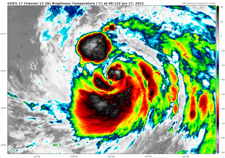
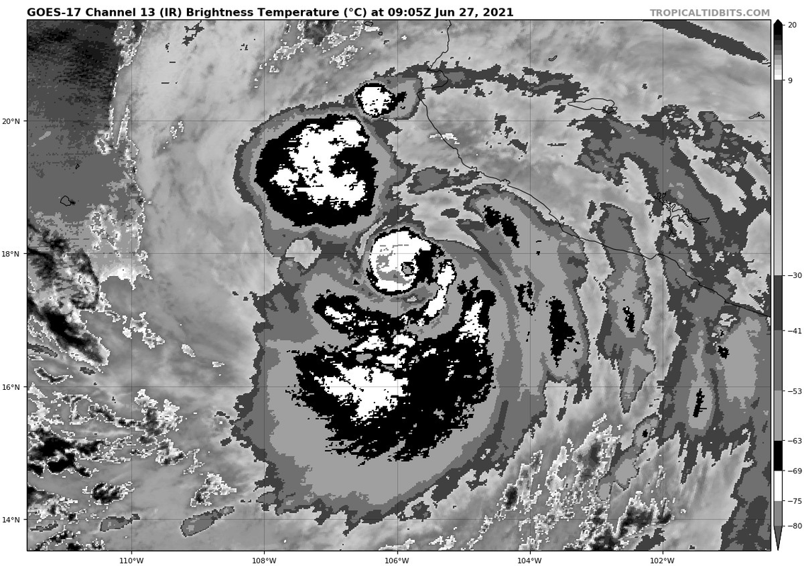
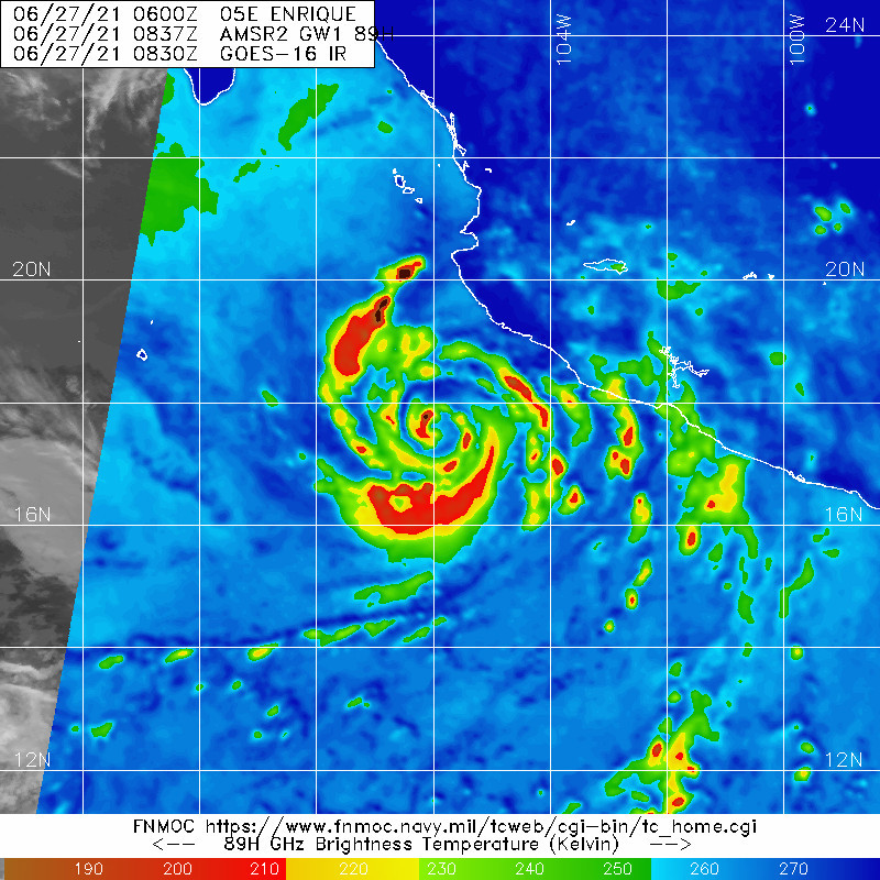
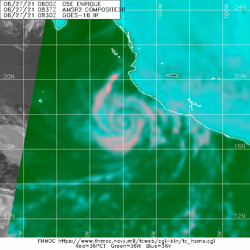
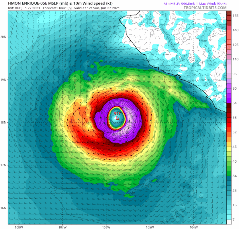
LOCATION...17.9N 105.9W
ABOUT 175 MI...280 KM S OF CABO CORRIENTES MEXICO
ABOUT 430 MI...695 KM SE OF CABO SAN LUCAS MEXICO
MAXIMUM SUSTAINED WINDS...90 MPH...150 KM/H
PRESENT MOVEMENT...N OR 360 DEGREES AT 4 MPH...6 KM/H
MINIMUM CENTRAL PRESSURE...977 MB...28.85 INCHES


WATCHES AND WARNINGS
--------------------
CHANGES WITH THIS ADVISORY:

None.

SUMMARY OF WATCHES AND WARNINGS IN EFFECT:

A Hurricane Watch is in effect for...
* Manzanillo to Cabo Corrientes Mexico

A Tropical Storm Warning is in effect for...
* Punta San Telmo to Punta Mita Mexico

A Tropical Storm Watch is in effect for...
* Punta Mita to San Blas Mexico

A Hurricane Watch means that hurricane conditions are possible
within the watch area, in this case within the next 24 to 36 hours.

A Tropical Storm Warning means that tropical storm conditions are
expected somewhere within the warning area.

A Tropical Storm Watch means that tropical storm conditions are
possible within the watch area, generally within 48 hours.

For storm information specific to your area, please monitor
products issued by your national meteorological service.


DISCUSSION AND OUTLOOK
----------------------
At 600 AM MDT (1200 UTC), the center of Hurricane Enrique was
located near latitude 17.9 North, longitude 105.9 West. Enrique is
moving toward the north near 4 mph (6 km/h). A north-northwest to
northwestward motion is expected during the next couple of days. On
the forecast track, the center of Enrique is expected to pass near
or just offshore of the southwestern coast of Mexico late today
through Monday.

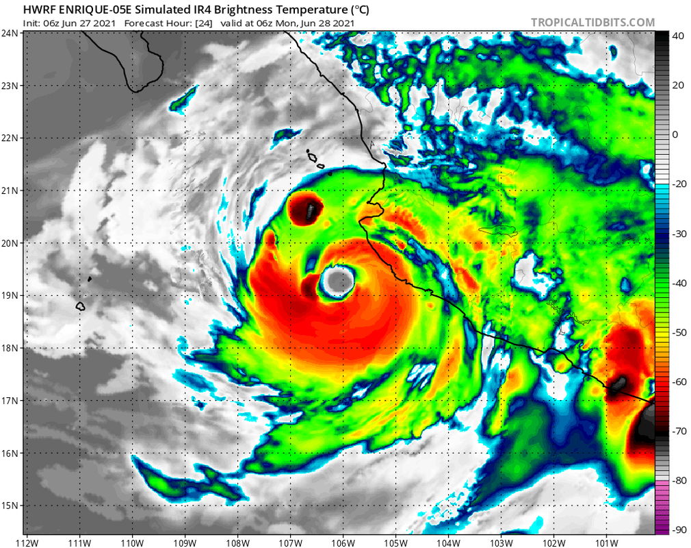
Maximum sustained winds are near 90 mph (150 km/h) with higher
gusts. Some additional slight strengthening is possible today.
Enrique is expected to begin to gradually weaken over cooler waters
on Monday and Tuesday.

Hurricane-force winds extend outward up to 25 miles (35 km) from
the center and tropical-storm-force winds extend outward up to 125
miles (205 km).

The estimated minimum central pressure is 977 mb (28.85 inches).


HAZARDS AFFECTING LAND
----------------------
Key messages for Hurricane Enrique can be found in the Tropical
Cyclone Discussion under AWIPS header MIATCDEP5, WMO header WTPZ45
KNHC, and on the web at
www.hurricanes.gov/graphics_ep5.shtml?key_messages.

WIND: Tropical storm conditions are occuring in portions of the
warning area and will continue to spread northwestward within the
warning area through tonight. Hurricane conditions are possible by
tonight in the Hurricane Watch area. Tropical storm conditions are
possible in the Tropical Storm Watch area today and Monday.

RAINFALL: Through Tuesday, The eastern outer bands of Enrique are
expected to produce total rainfall amounts of 6 to 12 inches with
isolated maximum amounts of 18 inches over Colima and coastal
sections of Jalisco, Michoacan, and northern Guerrero in southwest
Mexico. These amounts would likely produce life-threatening flash
flooding and mudslides over portions of southwestern Mexico.

SURF: Swells generated by Enrique will affect the southwestern
coast of Mexico during the next few days. These swells are likely
to cause life-threatening surf and rip current conditions. Please
consult products from your local weather office.


NEXT ADVISORY
-------------
Next complete advisory at 900 AM MDT.

$$
Forecaster Latto
0 likes   
Visit the Caribbean-Central America Weather Thread where you can find at first post web cams,radars
and observations from Caribbean basin members Click Here

User avatar
Yellow Evan
Professional-Met
Professional-Met
Posts: 15954
Age: 25
Joined: Fri Jul 15, 2011 12:48 pm
Location: Henderson, Nevada/Honolulu, HI
Contact:

Re: EPAC: ENRIQUE - Hurricane

#174 Postby Yellow Evan » Sun Jun 27, 2021 8:54 am

TXPZ24 KNES 271225
TCSENP

A. 05E (ENRIQUE)

B. 27/1130Z

C. 17.9N

D. 105.9W

E. THREE/GOES-W

F. T4.0/4.5

G. IR/EIR/SWIR

H. REMARKS...AN LLCC EMBEDDED IN MG YIELDS A DT OF 4.5. MET IS EQUAL
TO 4.5 AND PT IS 4.0 BASED ON A STEADY TREND IN THE LAST 24 HOURS. FT
IS BASED ON PT DUE TO UNCERTAINTY IN EXACT CENTER POSITION.

I. ADDL POSITIONS

NIL


...TUGGLE
0 likes   

User avatar
Yellow Evan
Professional-Met
Professional-Met
Posts: 15954
Age: 25
Joined: Fri Jul 15, 2011 12:48 pm
Location: Henderson, Nevada/Honolulu, HI
Contact:

Re: EPAC: ENRIQUE - Hurricane

#175 Postby Yellow Evan » Sun Jun 27, 2021 8:57 am

* GFS version *
* EAST PACIFIC 2021 SHIPS INTENSITY FORECAST *
* IR SAT DATA AVAILABLE, OHC AVAILABLE *
* ENRIQUE EP052021 06/27/21 12 UTC *

TIME (HR) 0 6 12 18 24 36 48 60 72 84 96 108 120 132 144 156 168
V (KT) NO LAND 80 79 76 72 70 65 58 49 40 32 24 18 N/A N/A N/A N/A N/A
V (KT) LAND 80 79 76 72 70 65 58 49 40 35 26 20 N/A N/A N/A N/A N/A
V (KT) LGEM 80 79 75 70 65 60 55 50 43 35 31 25 22 N/A N/A N/A N/A
Storm Type TROP TROP TROP TROP TROP TROP TROP TROP TROP TROP TROP TROP TROP N/A N/A N/A N/A

SHEAR (KT) 14 15 10 8 4 4 5 8 9 12 14 17 18 N/A N/A N/A N/A
SHEAR ADJ (KT) 5 7 1 1 0 -1 -2 -1 -1 0 -2 0 -1 N/A N/A N/A N/A
SHEAR DIR 71 87 85 78 61 25 58 103 126 121 141 153 184 N/A N/A N/A N/A
SST (C) 28.6 28.6 28.4 28.2 28.2 28.1 27.1 25.8 24.7 23.1 21.9 21.3 20.4 N/A N/A N/A N/A
POT. INT. (KT) 148 148 146 144 144 143 132 119 108 91 78 72 63 N/A N/A N/A N/A
200 MB T (C) -53.1 -52.7 -52.3 -52.8 -53.2 -52.8 -53.3 -53.1 -53.4 -53.3 -53.5 -53.0 -53.0 N/A N/A N/A N/A
200 MB VXT (C) 0.6 0.4 0.6 0.8 0.9 0.5 0.7 0.4 0.1 0.0 0.1 0.2 0.0 N/A N/A N/A N/A
TH_E DEV (C) 3 4 4 3 3 4 3 4 2 3 1 2 0 N/A N/A N/A N/A
700-500 MB RH 78 78 79 78 77 73 73 67 68 65 64 59 57 N/A N/A N/A N/A
MODEL VTX (KT) 21 19 13 12 12 9 9 7 6 4 3 2 2 LOST LOST LOST LOST
850 MB ENV VOR 59 71 99 84 78 87 68 58 39 37 25 8 12 N/A N/A N/A N/A
200 MB DIV 82 88 119 104 71 60 33 12 -1 8 2 -5 4 N/A N/A N/A N/A
700-850 TADV -16 -16 -4 -2 0 0 0 -1 -1 -2 0 1 1 N/A N/A N/A N/A
LAND (KM) 188 161 146 142 139 177 235 207 72 0 6 16 20 N/A N/A N/A N/A
LAT (DEG N) 17.9 18.4 18.9 19.3 19.7 20.4 20.9 21.6 22.5 23.2 23.7 24.3 25.0 N/A N/A N/A N/A
LONG(DEG W) 105.9 106.1 106.3 106.6 106.8 107.4 107.9 108.5 109.4 110.2 110.7 111.5 112.4 N/A N/A N/A N/A
STM SPEED (KT) 4 5 5 5 5 4 4 5 5 4 4 5 5 N/A N/A N/A N/A
HEAT CONTENT 12 12 11 10 10 13 4 0 0 0 0 0 0 N/A N/A N/A N/A

FORECAST TRACK FROM OFCI INITIAL HEADING/SPEED (DEG/KT):345/ 3 CX,CY: 0/ 3
T-12 MAX WIND: 75 PRESSURE OF STEERING LEVEL (MB): 461 (MEAN=587)
GOES IR BRIGHTNESS TEMP. STD DEV. 50-200 KM RAD: 11.2 (MEAN=14.5)
% GOES IR PIXELS WITH T < -20 C 50-200 KM RAD: 93.0 (MEAN=65.0)
PRELIM RI PROB (DV .GE. 35 KT IN 36 HR): 0.7

INDIVIDUAL CONTRIBUTIONS TO INTENSITY CHANGE
6 12 18 24 36 48 60 72 84 96 108 120 132 144 156 168
------------------------------------------------------------------------------
SAMPLE MEAN CHANGE 0. 0. 1. 1. 1. 2. 1. 1. 0. -0. -1. -2. -2. -3. -4. -4.
SST POTENTIAL 1. 1. 2. 2. 1. -3. -8. -12. -17. -22. -27. -33. -35. -38. -40. -43.
VERTICAL SHEAR MAG -1. -2. -2. -2. -0. 2. 3. 4. 5. 4. 3. 1. 1. 0. 0. 1.
VERTICAL SHEAR ADJ -0. -1. -1. -1. -1. -0. 0. 0. 0. 0. 0. 0. 0. 0. 0. 0.
VERTICAL SHEAR DIR 0. 0. 0. 0. -0. -1. -2. -2. -3. -4. -4. -3. -3. -3. -3. -2.
PERSISTENCE 1. 1. 1. 1. 1. 0. -0. -0. -0. -0. -0. -0. -0. -0. -0. -0.
200/250 MB TEMP. 0. -0. -0. -0. -1. -1. -1. -1. -0. -0. 0. 1. 1. 2. 3. 3.
THETA_E EXCESS -0. -1. -1. -2. -2. -4. -4. -5. -6. -7. -8. -9. -9. -10. -11. -12.
700-500 MB RH 0. 0. 0. 1. 1. 1. 1. 1. 1. 1. 1. 1. 1. 2. 3. 4.
MODEL VTX TENDENCY -1. -4. -6. -7. -9. -11. -17. -21. -23. -25. -25. -22. -20. -18. -17. -15.
850 MB ENV VORTICITY 0. 0. 0. 0. 0. -0. -0. -1. -1. -1. -1. -1. -1. -1. -1. -1.
200 MB DIVERGENCE 0. 1. 1. 1. 1. 1. 2. 1. 1. 0. -0. -0. -0. -0. 0. 0.
850-700 T ADVEC 0. 0. 0. 0. 0. -0. -0. -0. -0. -0. -0. -0. -0. -0. -0. -1.
ZONAL STORM MOTION -0. -0. -1. -1. -2. -3. -3. -3. -2. -2. -2. -2. -2. -1. -1. 0.
STEERING LEVEL PRES -0. -0. -1. -1. -1. -2. -2. -2. -2. -2. -3. -3. -2. -2. -1. -1.
DAYS FROM CLIM. PEAK -0. -0. -0. -0. -0. -0. -1. -1. -1. -2. -2. -2. -3. -3. -4. -5.
GOES PREDICTORS 0. 0. 0. 0. 1. 1. 2. 2. 2. 2. 2. 2. 3. 3. 2. 3.
OCEAN HEAT CONTENT -0. -0. -0. -0. -0. -0. -1. -1. -0. -0. 0. 1. 1. 2. 3. 5.
RI POTENTIAL -0. -1. -2. -2. -4. -4. -3. -1. 1. 2. 4. 4. 4. 4. 4. 4.
------------------------------------------------------------------------------
TOTAL CHANGE -1. -4. -8. -10. -15. -22. -31. -40. -48. -56. -62. -67. -66. -66. -65. -64.

CURRENT MAX WIND (KT): 80. LAT, LON: 17.9 105.9

** 2021 E. Pacific RI INDEX EP052021 ENRIQUE 06/27/21 12 UTC **
(SHIPS-RII PREDICTOR TABLE for 30 KT OR MORE MAXIMUM WIND INCREASE IN NEXT 24-h)

Predictor Value RI Predictor Range Scaled Value(0-1) % Contribution
POT = MPI-VMAX (KT) : 66.1 40.5 to 149.3 0.24 1.8
12 HR PERSISTENCE (KT) : 5.0 -22.0 to 44.0 0.41 3.6
D200 (10**7s-1) : 92.8 -33.0 to 159.5 0.65 4.6
850-200 MB SHEAR (KT) : 10.4 19.6 to 1.3 0.50 3.4
MAXIMUM WIND (KT) : 80.0 22.5 to 132.0 0.70 3.7
STD DEV OF IR BR TEMP : 11.2 37.8 to 2.1 0.75 3.6
BL DRY-AIR FLUX (W/M2) : 106.2 800.8 to -82.5 0.79 -4.2
HEAT CONTENT (KJ/CM2) : 11.0 2.7 to 106.7 0.08 0.3
%area of TPW <45 mm upshear : 0.0 56.6 to 0.0 1.00 1.5
2nd PC OF IR BR TEMP : 0.3 2.2 to -2.3 0.42 0.4

SHIPS Prob RI for 20kt/ 12hr RI threshold= 12% is 1.9 times climatological mean ( 6.3%)
SHIPS Prob RI for 25kt/ 24hr RI threshold= 22% is 1.8 times climatological mean (12.5%)
SHIPS Prob RI for 30kt/ 24hr RI threshold= 19% is 2.2 times climatological mean ( 8.6%)
SHIPS Prob RI for 35kt/ 24hr RI threshold= 18% is 2.8 times climatological mean ( 6.2%)
SHIPS Prob RI for 40kt/ 24hr RI threshold= 11% is 2.6 times climatological mean ( 4.2%)
SHIPS Prob RI for 45kt/ 36hr RI threshold= 15% is 2.2 times climatological mean ( 6.7%)
SHIPS Prob RI for 55kt/ 48hr RI threshold= 0% is 0.0 times climatological mean ( 5.9%)
SHIPS Prob RI for 65kt/ 72hr RI threshold= 0% is 0.0 times climatological mean ( 4.7%)

Matrix of RI probabilities
------------------------------------------------------------------------------
RI (kt / h) | 20/12 | 25/24 | 30/24 | 35/24 | 40/24 | 45/36 | 55/48 |65/72
------------------------------------------------------------------------------
SHIPS-RII: 12.0% 21.9% 18.7% 17.7% 10.9% 14.6% 0.0% 0.0%
Logistic: 2.1% 5.9% 2.8% 1.3% 0.3% 0.6% 0.1% 0.0%
Bayesian: 0.3% 0.4% 0.4% 0.2% 0.0% 0.0% 0.0% 0.0%
Consensus: 4.8% 9.4% 7.3% 6.4% 3.7% 5.1% 0.0% 0.0%
DTOPS: 2.0% 0.0% 0.0% 0.0% 0.0% 0.0% 0.0% 0.0%

## ANNULAR HURRICANE INDEX (AHI) EP052021 ENRIQUE 06/27/21 12 UTC ##
## STORM NOT ANNULAR, SCREENING STEP FAILED, NPASS=4 NFAIL=3 ##
## AHI= 0 (AHI OF 100 IS BEST FIT TO ANN. STRUC., 1 IS MARGINAL, 0 IS NOT ANNULAR) ##
0 likes   

User avatar
ElectricStorm
Category 5
Category 5
Posts: 4572
Age: 23
Joined: Tue Aug 13, 2019 11:23 pm
Location: Skiatook, OK / Norman, OK

Re: EPAC: ENRIQUE - Hurricane

#176 Postby ElectricStorm » Sun Jun 27, 2021 9:01 am

Doesn't look like it's going to get much stronger than it is now, but at least it became a hurricane. Hopefully Mexico doesn't get any major impacts from this.
2 likes   
I am in no way a professional. Take what I say with a grain of salt as I could be totally wrong. Please refer to the NHC, NWS, or SPC for official information.

Boomer Sooner!

Sciencerocks
Category 5
Category 5
Posts: 7287
Age: 38
Joined: Thu Jul 06, 2017 1:51 am

Re: EPAC: ENRIQUE - Hurricane

#177 Postby Sciencerocks » Sun Jun 27, 2021 10:08 am

Image
2 likes   

User avatar
Yellow Evan
Professional-Met
Professional-Met
Posts: 15954
Age: 25
Joined: Fri Jul 15, 2011 12:48 pm
Location: Henderson, Nevada/Honolulu, HI
Contact:

Re: EPAC: ENRIQUE - Hurricane

#178 Postby Yellow Evan » Sun Jun 27, 2021 12:02 pm

000
WTPZ45 KNHC 271447
TCDEP5

Hurricane Enrique Discussion Number 10
NWS National Hurricane Center Miami FL EP052021
1000 AM CDT Sun Jun 27 2021

Enrique has been holding its own over the past several hours, with
some warming of the cloud tops over the estimated center, suggesting
that an eye is attempting to form. The northern portion of the core
appears to be entraining some dry air, which is likely due to
down-sloping from the offshore flow over the mountainous terrain of
Mexico. Otherwise, the core of the hurricane appears well intact,
and the latest Dvorak intensity estimate T-number from TAFB
indicates that the initial intensity remains 80 kt for this
advisory.

Enrique has been wobbling on a nearly due north trajectory for the
past 12 h or so, while the forward motion has appeared to increase
to about 5 kt. There is little change to the forecast track
reasoning. Embedded in generally weak steering flow, Enrique is
forecast to move toward a mid-level trough over northwestern Mexico.
This trough is expected to gradually fill in over the next day or
so, causing the system to turn to the north-northwest. By late
Monday and Tuesday, the weakening cyclone should turn northwestward
as it becomes steered by the lower-tropospheric environmental flow.
The latest NHC track forecast is very near the previous one, and is
close to the TVCE consensus.

Overall, the environment surrounding Enrique is favorable for
strengthening in the near term. On Monday, the hurricane is forecast
to begin moving over waters of decreasing oceanic heat content. Due
to the fairly slow motion of the cyclone over these waters,
upwelling should bring cooler waters to the surface. This would
induce a gradual weakening trend beginning sometime tomorrow. By
Tuesday, the cyclone is expected to begin moving over much cooler
waters and into a drier and stable atmospheric environment, which
will hasten the pace of weakening. Most of the guidance shows
Enrique becoming a remnant low very near the time it reaches the
southern Baja California peninsula, with the low dissipating a short
time thereafter. Other than indicating a little faster transition to
a remnant low and dissipation, the official intensity forecast is
very similar to the previous one, near the high end of the guidance
through 36 h, and then a blend of the SHIPS/LGEM models and the
intensity consensus after 36 h.


Key Messages:

1. The outer rainbands of Enrique are likely to produce heavy rains
across a portion of southwestern Mexico during the next couple of
days, which would likely cause life-threatening flash flooding and
mudslides.

2. Tropical-storm-force winds are expected to continue across
portions of southwestern Mexico through early Monday. Although the
core of Enrique is still forecast to remain just offshore, any
deviation to the right of the forecast track or expansion of the
wind field could bring even stronger winds onshore over a portion of
the southwestern coast of Mexico. Therefore, a Hurricane Watch
remains in effect for a portion of that area.

3. Swells generated by Enrique are expected to affect the
southwestern coast of Mexico during the next few days. These swells
could cause life-threatening surf and rip currents.


FORECAST POSITIONS AND MAX WINDS

INIT 27/1500Z 18.2N 105.9W 80 KT 90 MPH
12H 28/0000Z 19.1N 106.3W 85 KT 100 MPH
24H 28/1200Z 19.9N 106.9W 80 KT 90 MPH
36H 29/0000Z 20.6N 107.5W 70 KT 80 MPH
48H 29/1200Z 21.1N 108.0W 60 KT 70 MPH
60H 30/0000Z 21.8N 108.6W 50 KT 60 MPH
72H 30/1200Z 22.6N 109.4W 40 KT 45 MPH
96H 01/1200Z 24.0N 111.0W 30 KT 35 MPH...POST-TROP/REMNT LOW
120H 02/1200Z...DISSIPATED

$$
Forecaster Latto/Stewart
0 likes   

User avatar
Yellow Evan
Professional-Met
Professional-Met
Posts: 15954
Age: 25
Joined: Fri Jul 15, 2011 12:48 pm
Location: Henderson, Nevada/Honolulu, HI
Contact:

Re: EPAC: ENRIQUE - Hurricane

#179 Postby Yellow Evan » Sun Jun 27, 2021 1:20 pm

TXPZ24 KNES 271758
TCSENP

A. 05E (ENRIQUE)

B. 27/1730Z

C. 18.6N

D. 105.6W

E. THREE/GOES-W

F. T4.0/4.0

G. IR/EIR/VIS

H. REMARKS...12.5/10 BANDING AROUND THE LLCC YIELDS A DT OF 4.0. MET
AND PT ARE EQUAL TO 4.5 BASED ON A STEADY TREND IN THE LAST 24 HOURS. FT
IS BASED ON DT.

I. ADDL POSITIONS

NIL


...TUGGLE
0 likes   

zeehag
Tropical Storm
Tropical Storm
Posts: 172
Age: 75
Joined: Sun Jul 17, 2011 9:49 pm
Location: mazatlan,sinaloa, mexico, fixing patricia's mess.
Contact:

Re: EPAC: ENRIQUE - Hurricane

#180 Postby zeehag » Sun Jun 27, 2021 1:21 pm

i hope it remembers to turn northwest.
glad i have a trash pump to use for emptying my dinghy. some of these have been 2 pump storms, when water gets 10 inches deep each time.
we so need the water, but not the blowdry.
the models i have been able to see, ecmwf and gfs, our normally most accurate for us, show it breaking up by the prison islands and plundering cabo san lucas with a weak and dying attempt, with some weather sent up sea on baja side to terrorize anchored sailboat cruisers.
if this lil storm is well behaved i may sit out in cockpit to watch it blow by. if it is not well behaved i will be a busy sailorette or inside reassuring cats they wont die. .
0 likes   
life is an adventure meant to be LIVED!!!

http://www.sksolitarybird.org


Return to “2021”

Who is online

Users browsing this forum: No registered users and 26 guests