ATL: ELSA - Post-Tropical - Discussion

Moderator: S2k Moderators

Message
Author
SconnieCane
Category 4
Category 4
Posts: 913
Joined: Thu Aug 02, 2018 5:29 pm
Location: Madison, WI

Re: ATL: INVEST 97L - Discussion

#81 Postby SconnieCane » Tue Jun 29, 2021 8:33 pm

crownweather wrote:
Chris90 wrote:I've seen Dennis and Emily mentioned recently with these early vigorous waves traversing the basin at a low latitude, but the storm I've been thinking of is the 1933 Trinidad hurricane. It was a late June - early July storm that moved at a low latitude, one of only 3 cyclones to produce hurricane force winds in Venezuela, and moved into the Caribbean and then the Gulf. Peaked at 95kts/965mb in the official record (although it's 1933 data, so the margin of error is greater.)
https://en.m.wikipedia.org/wiki/1933_Trinidad_hurricane

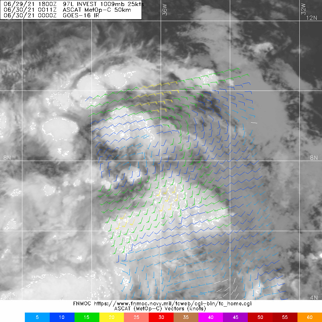
Early season storms/hurricanes are rare in the MDR, especially traveling into the Caribbean, but it's happened.


Interesting that you mention that storm, because we broke record highs today up here in New England set in 1933.

So.....


Also worth noting that it came in 1933, the previous seasonal activity record holder before 2005. We can debate to what extent July activity portends that of ASO, but if we do get a Cat 2+ Caribbean cruiser out of this... :eek: :eek: :eek:
2 likes   

User avatar
InfernoFlameCat
Category 5
Category 5
Posts: 1966
Age: 21
Joined: Mon Dec 14, 2020 10:52 am
Location: Buford, GA

Re: ATL: INVEST 97L - Discussion

#82 Postby InfernoFlameCat » Tue Jun 29, 2021 9:14 pm

SoupBone wrote:
Kazmit wrote:The second MDR invest this June, and this one looks way more likely to develop. Just wait until two months from now...


A front-loaded season isn't a harbinger for the remaining part of the season. That's the beauty of the weather, it's ever-changing. I don't like these early season threats, but we have seen seasons with several threats early that ended up being normal hurricane seasons.
However when concerning Cabo Verde systems it bears an ominous sight of what’s to become. This early for strong waves to be moving in favorable environments is highly unusual.
5 likes   
I am by no means a professional. DO NOT look at my forecasts for official information or make decisions based on what I post.

Goal: to become a registered expert over tropical and subtropical cyclones.

User avatar
MGC
S2K Supporter
S2K Supporter
Posts: 5794
Joined: Sun Mar 23, 2003 9:05 pm
Location: Pass Christian MS, or what is left.

Re: ATL: INVEST 97L - Discussion

#83 Postby MGC » Tue Jun 29, 2021 9:14 pm

97L starting to get that tumbleweed look. If convection persists could very well be upgraded in a day or two.....MGC
6 likes   

User avatar
crownweather
S2K Supporter
S2K Supporter
Posts: 578
Age: 49
Joined: Sat Aug 12, 2006 9:21 am
Location: Sturbridge, Massachusetts
Contact:

Re: ATL: INVEST 97L - Discussion

#84 Postby crownweather » Tue Jun 29, 2021 9:18 pm

4 likes   
Rob Lightbown
Crown Weather Services
https://crownweather.com

User avatar
InfernoFlameCat
Category 5
Category 5
Posts: 1966
Age: 21
Joined: Mon Dec 14, 2020 10:52 am
Location: Buford, GA

Re: ATL: INVEST 97L - Discussion

#85 Postby InfernoFlameCat » Tue Jun 29, 2021 9:25 pm

If this system manages to squeeze past every bit of land in its way whilst having favorable conditions as forecast, I recon it could make it to cat 3. My odds of that are 0.1 percent on that though.
0 likes   
I am by no means a professional. DO NOT look at my forecasts for official information or make decisions based on what I post.

Goal: to become a registered expert over tropical and subtropical cyclones.

MarioProtVI
Category 2
Category 2
Posts: 671
Age: 22
Joined: Sun Sep 29, 2019 7:33 pm
Location: New Jersey

Re: ATL: INVEST 97L - Discussion

#86 Postby MarioProtVI » Tue Jun 29, 2021 9:40 pm

This is getting its act together fast.
1 likes   

User avatar
tropicwatch
Category 5
Category 5
Posts: 3205
Age: 60
Joined: Sat Jun 02, 2007 10:01 am
Location: Panama City Florida
Contact:

Re: ATL: INVEST 97L - Discussion

#87 Postby tropicwatch » Tue Jun 29, 2021 9:45 pm

ASCAT caught 97L about two hours ago and I think they could already classify this as a depression.
Image
8 likes   
Tropicwatch


Agnes 72', Eloise 75, Elena 85', Kate 85', Charley 86', Florence 88', Beryl 94', Dean 95', Erin 95', Opal 95', Earl 98', Georges 98', Ivan 2004', Arlene 2005', Dennis 2005', Ida 2009' Debby 2012' Irma 2017' Michael 2018'

Senobia
Category 1
Category 1
Posts: 274
Joined: Sat Aug 05, 2006 2:59 pm
Location: Somewhere over the rainbow

Re: ATL: INVEST 97L - Discussion

#88 Postby Senobia » Tue Jun 29, 2021 9:47 pm

I asked one of our local meteorologists if it was possible for 97 and 95 to either slow down or speed up so one catches up with the other and they combine energies. His response was not likely, but that 95 is helping 97 develop by dealing with/absorbing some of the dry air ahead.
5 likes   

User avatar
eastcoastFL
Category 5
Category 5
Posts: 3437
Age: 42
Joined: Thu Apr 12, 2007 12:29 pm
Location: Palm City, FL

Re: ATL: INVEST 97L - Discussion

#89 Postby eastcoastFL » Tue Jun 29, 2021 10:11 pm

Image


Image
6 likes   
Personal Forecast Disclaimer:
The posts in this forum are NOT official forecast and should not be used as such. They are just the opinion of the poster and may or may not be backed by sound meteorological data. They are NOT endorsed by any professional institution or storm2k.org. For official information, please refer to the NHC and NWS products.

User avatar
Blown Away
S2K Supporter
S2K Supporter
Posts: 9867
Joined: Wed May 26, 2004 6:17 am

Re: ATL: INVEST 97L - Discussion

#90 Postby Blown Away » Tue Jun 29, 2021 10:13 pm

https://www.tropicaltidbits.com/sat/sat ... product=ir

97L looking healthy and appears to be gaining a little more latitude this evening. My guard is up buying into an MDR system in June, but ATM it appears to be a go.
4 likes   
Hurricane Eye Experience: David 79, Irene 99, Frances 04, Jeanne 04, Wilma 05... EYE COMING MY WAY IN 2024…
Hurricane Brush Experience: Andrew 92, Erin 95, Floyd 99, Matthew 16, Irma 17, Ian 22, Nicole 22…

User avatar
eastcoastFL
Category 5
Category 5
Posts: 3437
Age: 42
Joined: Thu Apr 12, 2007 12:29 pm
Location: Palm City, FL

Re: ATL: INVEST 97L - Discussion

#91 Postby eastcoastFL » Tue Jun 29, 2021 10:17 pm

Blown Away wrote:https://www.tropicaltidbits.com/sat/satlooper.php?region=97L&product=ir

97L looking healthy and appears to be gaining a little more latitude this evening. My guard is up buying into an MDR system in June, but ATM it appears to be a go.


I feel the same way this time of year but I’d more surprised now if this one doesn’t form. I just hope it stays clear of south Florida while the search and rescue efforts continue.
5 likes   
Personal Forecast Disclaimer:
The posts in this forum are NOT official forecast and should not be used as such. They are just the opinion of the poster and may or may not be backed by sound meteorological data. They are NOT endorsed by any professional institution or storm2k.org. For official information, please refer to the NHC and NWS products.

User avatar
Stormybajan
Category 1
Category 1
Posts: 428
Joined: Thu May 20, 2021 3:21 pm
Location: Windward Islands

Re: ATL: INVEST 97L - Discussion

#92 Postby Stormybajan » Tue Jun 29, 2021 10:25 pm


Sure does look like it taking up a lot of space..maybe being so broad can slow down development a bit? I cant remember the last time we've had a strong early season MDR system...I guess that would have been Hurricane Beryl in 2018? I've been a lurker on here for about nearly 4 years, when storm2k is at a stir for a system thats not even developed as yet..you have to watch it closely. (Especially if youre in its pathway :double: )
2 likes   
Sad West Indies and Manchester United fan ⚽️

User avatar
Blown Away
S2K Supporter
S2K Supporter
Posts: 9867
Joined: Wed May 26, 2004 6:17 am

Re: ATL: INVEST 97L - Discussion

#93 Postby Blown Away » Tue Jun 29, 2021 10:25 pm

eastcoastFL wrote:
Blown Away wrote:https://www.tropicaltidbits.com/sat/satlooper.php?region=97L&product=ir

97L looking healthy and appears to be gaining a little more latitude this evening. My guard is up buying into an MDR system in June, but ATM it appears to be a go.


I feel the same way this time of year but I’d more surprised now if this one doesn’t form. I just hope it stays clear of south Florida while the search and rescue efforts continue.


Next few model runs will likely decide either a general WNW path into Caribbean below the big islands and likely stay S of the FL peninsula into CA or GOM or a path near or into Big islands and near FL peninsula or E...
0 likes   
Hurricane Eye Experience: David 79, Irene 99, Frances 04, Jeanne 04, Wilma 05... EYE COMING MY WAY IN 2024…
Hurricane Brush Experience: Andrew 92, Erin 95, Floyd 99, Matthew 16, Irma 17, Ian 22, Nicole 22…

User avatar
eastcoastFL
Category 5
Category 5
Posts: 3437
Age: 42
Joined: Thu Apr 12, 2007 12:29 pm
Location: Palm City, FL

Re: ATL: INVEST 97L - Discussion

#94 Postby eastcoastFL » Tue Jun 29, 2021 10:33 pm

Blown Away wrote:
eastcoastFL wrote:
Blown Away wrote:https://www.tropicaltidbits.com/sat/satlooper.php?region=97L&product=ir

97L looking healthy and appears to be gaining a little more latitude this evening. My guard is up buying into an MDR system in June, but ATM it appears to be a go.


I feel the same way this time of year but I’d more surprised now if this one doesn’t form. I just hope it stays clear of south Florida while the search and rescue efforts continue.


Next few model runs will likely decide either a general WNW path into Caribbean below the big islands and likely stay S of the FL peninsula into CA or GOM or a path near or into Big islands and near FL peninsula or E...


I saw one yesterday bringing it into the gom heading towards LA and the one I saw today was heading for the Panhandle. Hopefully that trend continues and it misses us and everyone else to the East. Really odd to even be considering an MDR threat in June.
0 likes   
Personal Forecast Disclaimer:
The posts in this forum are NOT official forecast and should not be used as such. They are just the opinion of the poster and may or may not be backed by sound meteorological data. They are NOT endorsed by any professional institution or storm2k.org. For official information, please refer to the NHC and NWS products.

User avatar
Category5Kaiju
Category 5
Category 5
Posts: 3398
Age: 22
Joined: Thu Dec 24, 2020 12:45 pm
Location: Seattle

Re: ATL: INVEST 97L - Discussion

#95 Postby Category5Kaiju » Tue Jun 29, 2021 10:37 pm

I sincerely cannot believe that we are talking about an MDR-born threat in June, let alone beating last year's earliest 5th named storm record. I hope future Elsa is not going to be a sign of things to come, especially if and when that predicted very intense velocity signature in early August comes into the picture.
8 likes   
Unless explicitly stated, all information covered in my posts is based on my opinions and observations. Please refer to a professional meteorologist or an accredited weather research agency otherwise, especially if serious decisions must be made in the event of a potentially life-threatening tropical storm or hurricane.

User avatar
chaser1
S2K Supporter
S2K Supporter
Posts: 4713
Age: 63
Joined: Sat Oct 15, 2005 5:59 pm
Location: Longwood, Fl

Re: ATL: INVEST 97L - Discussion

#96 Postby chaser1 » Tue Jun 29, 2021 11:57 pm

This is not simply your early season El Nino spat of northern latitude sub-tropical gales. Those early seasons rarely represented any true indication of a busy August or September. 97L looks like the sprawling overstuffed pig disturbances that we commonly see roll up during the height of so many Pacific seasons. Aside from it being June, and aside from the large envelope system that 97L appears to have... I find it interesting how this systems apparent lifespan is far more apt to be determined by potential land interaction then it is anticipated to be by adverse upper level wind shear. 97L seems destined to be a legit threat to the greater Antilles - even if that threat be imited to being a minimal hurricane. The real threat is yet to come. Don't believe this storm will be a harbinger of things to come later in the season?? Think again.
15 likes   
Personal Forecast Disclaimer:
The posts in this forum are NOT official forecast and should not be used as such. They are just the opinion of the poster and may or may not be backed by sound meteorological data. They are NOT endorsed by any professional institution or storm2k.org. For official information, please refer to the NHC and NWS products.


AxaltaRacing24
Category 5
Category 5
Posts: 1709
Age: 24
Joined: Wed Jul 27, 2016 11:14 am
Location: Jupiter, FL

Re: ATL: INVEST 97L - Discussion

#97 Postby AxaltaRacing24 » Wed Jun 30, 2021 12:05 am

chaser1 wrote:This is not simply your early season El Nino spat of northern latitude sub-tropical gales. Those early seasons rarely represented any true indication of a busy August or September. 97L looks like the sprawling overstuffed pig disturbances that we commonly see roll up during the height of so many Pacific seasons. Aside from it being June, and aside from the large envelope system that 97L appears to have... I find it interesting how this systems apparent lifespan is far more apt to be determined by potential land interaction then it is anticipated to be by adverse upper level wind shear. 97L seems destined to be a legit threat to the greater Antilles - even if that threat be imited to being a minimal hurricane. The real threat is yet to come. Don't believe this storm will be a harbinger of things to come later in the season?? Think again.

Well said. Below average to near average seasons usually don't have waves like 96L and 97L in June. It is obvious that this is foreshadowing another active or potentially hyperactive season that will feature a more favorable MDR than 2020 did.
4 likes   

Sciencerocks
Category 5
Category 5
Posts: 7287
Age: 38
Joined: Thu Jul 06, 2017 1:51 am

Re: ATL: INVEST 97L - Discussion

#98 Postby Sciencerocks » Wed Jun 30, 2021 12:32 am

Image
8 likes   

User avatar
Category5Kaiju
Category 5
Category 5
Posts: 3398
Age: 22
Joined: Thu Dec 24, 2020 12:45 pm
Location: Seattle

Re: ATL: INVEST 97L - Discussion

#99 Postby Category5Kaiju » Wed Jun 30, 2021 12:34 am

Well I also think based on what we have been seeing so far that any potential comments regarding a future "2013 2.0" for this season are thrown out the window. Did 2013 have this kind of robust MDR activity so early in the season? :D
4 likes   
Unless explicitly stated, all information covered in my posts is based on my opinions and observations. Please refer to a professional meteorologist or an accredited weather research agency otherwise, especially if serious decisions must be made in the event of a potentially life-threatening tropical storm or hurricane.

User avatar
weeniepatrol
Category 3
Category 3
Posts: 866
Joined: Sat Aug 22, 2020 5:30 pm
Location: WA State

Re: ATL: INVEST 97L - Discussion

#100 Postby weeniepatrol » Wed Jun 30, 2021 12:42 am

Image

For the North Atlantic...Caribbean Sea and the Gulf of Mexico:

1. A broad area of low pressure, associated with a tropical wave, is
located about midway between the west coast of Africa and the
Windward Islands. This system is producing a large area of showers
and thunderstorms that continues to show some signs of organization.
Environmental conditions appear generally favorable for development,
and a tropical depression is likely form during the next few days
while the system moves west-northwestward at about 20 mph.
Interests in the Windward and Leeward Islands should closely
monitor this system as it will likely be moving through that region
on Friday.
* Formation chance through 48 hours...medium...50 percent.
* Formation chance through 5 days...high...70 percent.
6 likes   


Return to “2021”

Who is online

Users browsing this forum: No registered users and 18 guests