AL, 98, 2021071018, , BEST, 0, 407N, 641W, 35, 1012, DB, 34, NEQ, 0, 40, 0, 0, 1014, 50, 30, 0, 0, L, 0, , 0, 0, INVEST, S, 0, , 0, 0, 0, 0, genesis-num, 012, SPAWNINVEST, al732021 to al982021,
ATL: INVEST 98L - Discussion
Moderator: S2k Moderators
-
AlphaToOmega
- Category 5

- Posts: 1448
- Joined: Sat Jun 26, 2021 10:51 am
- Location: Somewhere in Massachusetts
-
tolakram
- Admin

- Posts: 19165
- Age: 60
- Joined: Sun Aug 27, 2006 8:23 pm
- Location: Florence, KY (name is Mark)
Re: ATL: INVEST 98L
AlphaToOmega wrote:AL, 98, 2021071018, , BEST, 0, 407N, 641W, 35, 1012, DB, 34, NEQ, 0, 40, 0, 0, 1014, 50, 30, 0, 0, L, 0, , 0, 0, INVEST, S, 0, , 0, 0, 0, 0, genesis-num, 012, SPAWNINVEST, al732021 to al982021,
A link is required to start an invest thread, where did you get this?
0 likes
M a r k
- - - - -
Join us in chat: Storm2K Chatroom Invite. Android and IOS apps also available.
The posts in this forum are NOT official forecasts and should not be used as such. Posts are NOT endorsed by any professional institution or STORM2K.org. For official information and forecasts, please refer to NHC and NWS products.
-
AlphaToOmega
- Category 5
- Posts: 1448
- Joined: Sat Jun 26, 2021 10:51 am
- Location: Somewhere in Massachusetts
Re: ATL: INVEST 98L
tolakram wrote:AlphaToOmega wrote:AL, 98, 2021071018, , BEST, 0, 407N, 641W, 35, 1012, DB, 34, NEQ, 0, 40, 0, 0, 1014, 50, 30, 0, 0, L, 0, , 0, 0, INVEST, S, 0, , 0, 0, 0, 0, genesis-num, 012, SPAWNINVEST, al732021 to al982021,
A link is required to start an invest thread, where did you get this?
Here: https://ftp.nhc.noaa.gov/atcf/btk/
1 likes
-
tolakram
- Admin
- Posts: 19165
- Age: 60
- Joined: Sun Aug 27, 2006 8:23 pm
- Location: Florence, KY (name is Mark)
Re: ATL: INVEST 98L
Way up north  I was trying to find this one. Showing up on the map now.
0 likes
M a r k
- - - - -
Join us in chat: Storm2K Chatroom Invite. Android and IOS apps also available.
The posts in this forum are NOT official forecasts and should not be used as such. Posts are NOT endorsed by any professional institution or STORM2K.org. For official information and forecasts, please refer to NHC and NWS products.
- - - - -
Join us in chat: Storm2K Chatroom Invite. Android and IOS apps also available.
The posts in this forum are NOT official forecasts and should not be used as such. Posts are NOT endorsed by any professional institution or STORM2K.org. For official information and forecasts, please refer to NHC and NWS products.
-
ElectricStorm

- Category 5
- Posts: 4565
- Age: 23
- Joined: Tue Aug 13, 2019 11:23 pm
- Location: Skiatook, OK / Norman, OK
Re: ATL: INVEST 98L
Wow an invest before being highlighted on the TWO. That doesn't happen much
2 likes
I am in no way a professional. Take what I say with a grain of salt as I could be totally wrong. Please refer to the NHC, NWS, or SPC for official information.
Boomer Sooner!
Boomer Sooner!
-
tolakram
- Admin
- Posts: 19165
- Age: 60
- Joined: Sun Aug 27, 2006 8:23 pm
- Location: Florence, KY (name is Mark)
Re: ATL: INVEST 98L
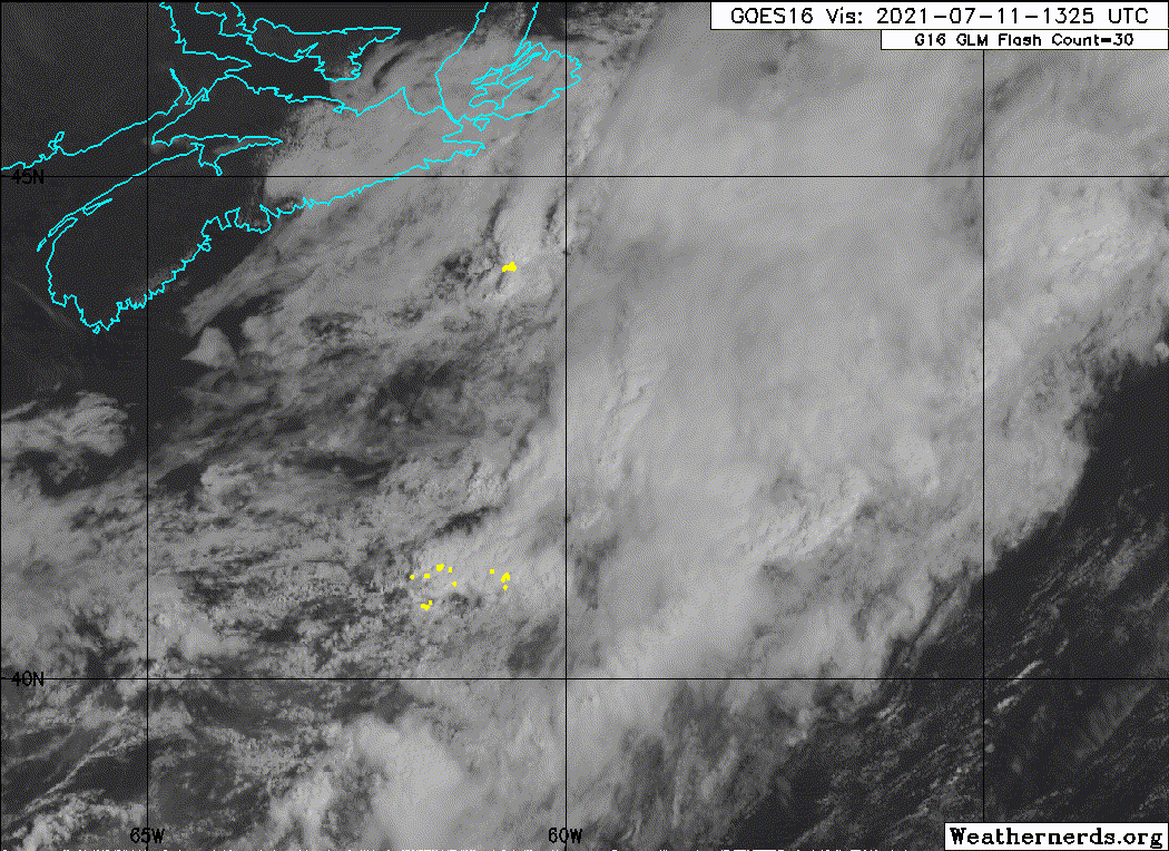
Isn't this the remnants of Elsa?
You can clearly see the LLC here: https://rammb-slider.cira.colostate.edu ... aw_width=6
You can clearly see the LLC here: https://rammb-slider.cira.colostate.edu ... aw_width=6
1 likes
M a r k
- - - - -
Join us in chat: Storm2K Chatroom Invite. Android and IOS apps also available.
The posts in this forum are NOT official forecasts and should not be used as such. Posts are NOT endorsed by any professional institution or STORM2K.org. For official information and forecasts, please refer to NHC and NWS products.
- - - - -
Join us in chat: Storm2K Chatroom Invite. Android and IOS apps also available.
The posts in this forum are NOT official forecasts and should not be used as such. Posts are NOT endorsed by any professional institution or STORM2K.org. For official information and forecasts, please refer to NHC and NWS products.
-
AlphaToOmega
- Category 5
- Posts: 1448
- Joined: Sat Jun 26, 2021 10:51 am
- Location: Somewhere in Massachusetts
Re: ATL: INVEST 98L
I was on the Tropical Tidbits website, and then I read "Invest 98L". My first reaction was, "is this a bug?". I checked ftp.nhc.noaa.gov, and sure enough, it was there. It looks quite interesting on the satellite. The GFS and CMC try to develop it; whether it will develop, we cannot say. If development did occur, it would likely be subtropical given its latitude.
1 likes
-
AlphaToOmega
- Category 5
- Posts: 1448
- Joined: Sat Jun 26, 2021 10:51 am
- Location: Somewhere in Massachusetts
Re: ATL: INVEST 98L
tolakram wrote:Isn't this the remnants of Elsa?
You can clearly see the LLC here: https://rammb-slider.cira.colostate.edu ... aw_width=6
If anything, this is probably just leftover energy from Elsa. The Remnants of Elsa are over the Labrador Sea.
0 likes
-
AlphaToOmega
- Category 5
- Posts: 1448
- Joined: Sat Jun 26, 2021 10:51 am
- Location: Somewhere in Massachusetts
Re: ATL: INVEST 98L
SSTs seems conducive enough for subtropical development, and tropical development is possible but unlikely.
0 likes
-
AnnularCane

- S2K Supporter

- Posts: 2635
- Joined: Thu Jun 08, 2006 9:18 am
- Location: Wytheville, VA
Re: ATL: INVEST 98L
Could this maybe be one of those "test invests?" (I think that's what that is?)
0 likes
"But it never rained rain. It never snowed snow. And it never blew just wind. It rained things like soup and juice. It snowed mashed potatoes and green peas. And sometimes the wind blew in storms of hamburgers." -- Judi Barrett, Cloudy with a Chance of Meatballs
-
AlphaToOmega
- Category 5
- Posts: 1448
- Joined: Sat Jun 26, 2021 10:51 am
- Location: Somewhere in Massachusetts
Re: ATL: INVEST 98L
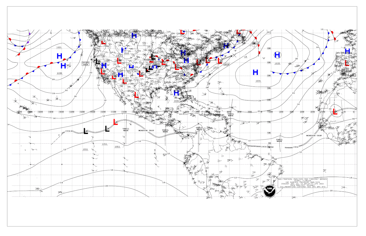
ZCZC MIATWOAT ALL
TTAA00 KNHC DDHHMM
Tropical Weather Outlook
NWS National Hurricane Center Miami FL
800 PM EDT Sat Jul 10 2021
For the North Atlantic...Caribbean Sea and the Gulf of Mexico:
1. A small area of low pressure is located less than 500 miles
southwest of the southern tip of Newfoundland, Canada. Earlier
satellite wind data indicated the system was producing gale force
winds to its southeast. However, shower and thunderstorm
activity near the system is disorganized and has diminished
some this evening. Additional development of this system is
unlikely while it accelerates to the northeast over increasingly
cool ocean waters. Additional information on this system can be
found in High Seas Forecasts issued by the National Weather Service.
* Formation chance through 48 hours...low...10 percent.
* Formation chance through 5 days...low...10 percent.
High Seas Forecasts issued by the National Weather Service
can be found under AWIPS header NFDHSFAT1, WMO header FZNT01
KWBC, and online at ocean.weather.gov/shtml/NFDHSFAT1.php
Forecaster Papin/Blake
1 likes
-
AlphaToOmega
- Category 5
- Posts: 1448
- Joined: Sat Jun 26, 2021 10:51 am
- Location: Somewhere in Massachusetts
-
ElectricStorm
- Category 5
- Posts: 4565
- Age: 23
- Joined: Tue Aug 13, 2019 11:23 pm
- Location: Skiatook, OK / Norman, OK
Re: ATL: INVEST 98L
I'll be shocked if this develops but at least we have something to track
1 likes
I am in no way a professional. Take what I say with a grain of salt as I could be totally wrong. Please refer to the NHC, NWS, or SPC for official information.
Boomer Sooner!
Boomer Sooner!
-
AlphaToOmega
- Category 5
- Posts: 1448
- Joined: Sat Jun 26, 2021 10:51 am
- Location: Somewhere in Massachusetts
-
AlphaToOmega
- Category 5
- Posts: 1448
- Joined: Sat Jun 26, 2021 10:51 am
- Location: Somewhere in Massachusetts
Re: ATL: INVEST 98L
ZCZC MIATWOAT ALL
TTAA00 KNHC DDHHMM
Tropical Weather Outlook
NWS National Hurricane Center Miami FL
200 AM EDT Sun Jul 11 2021
For the North Atlantic...Caribbean Sea and the Gulf of Mexico:
1. A small low pressure system located about 250 miles southwest of
Cape Race, Newfoundland, is producing limited shower activity. The
low is forecast to continue accelerating northeastward over colder
ocean waters, and tropical cyclone development is not expected.
Additional information on this system can be found in High Seas
Forecasts issued by the National Weather Service.
* Formation chance through 48 hours...low...near 0 percent.
* Formation chance through 5 days...low...near 0 percent.
High Seas Forecasts issued by the National Weather Service can be
found under AWIPS header NFDHSFAT1, WMO header FZNT01 KWBC, and
online at ocean.weather.gov/shtml/NFDHSFAT1.php
Forecaster Stewart
AL, 98, 2021071100, , BEST, 0, 420N, 612W, 35, 1012, DB, 34, NEQ, 0, 40, 0, 0, 1014, 50, 30, 0, 0, L, 0, , 0, 0, INVEST, S, 0, , 0, 0, 0, 0, genesis-num, 012,
1 likes
-
Sciencerocks
- Category 5
- Posts: 7286
- Age: 38
- Joined: Thu Jul 06, 2017 1:51 am
Re: ATL: INVEST 98L
Last edited by tolakram on Sun Jul 11, 2021 3:29 pm, edited 1 time in total.
Reason: fixed image link
Reason: fixed image link
0 likes
-
AlphaToOmega
- Category 5
- Posts: 1448
- Joined: Sat Jun 26, 2021 10:51 am
- Location: Somewhere in Massachusetts
Re: ATL: INVEST 98L - Discussion
This disturbance is still around
https://www.tropicaltidbits.com/sat/satlooper.php?region=98L&product=ir
https://www.tropicaltidbits.com/sat/satlooper.php?region=98L&product=ir
0 likes
-
InfernoFlameCat

- Category 5
- Posts: 1966
- Age: 21
- Joined: Mon Dec 14, 2020 10:52 am
- Location: Buford, GA
Re: ATL: INVEST 98L
subtropical development is not inhibited by Mjo phase as much as the MDR. Also looks like this invest is going to be a nothing.Teban54 wrote:I thought we're supposed to be in a lull?

0 likes
I am by no means a professional. DO NOT look at my forecasts for official information or make decisions based on what I post.
Goal: to become a registered expert over tropical and subtropical cyclones.
Goal: to become a registered expert over tropical and subtropical cyclones.
Who is online
Users browsing this forum: No registered users and 23 guests