000
WTPZ41 KNHC 191435
TCDEP1
Hurricane Felicia Discussion Number 22
NWS National Hurricane Center Miami FL EP062021
500 AM HST Mon Jul 19 2021
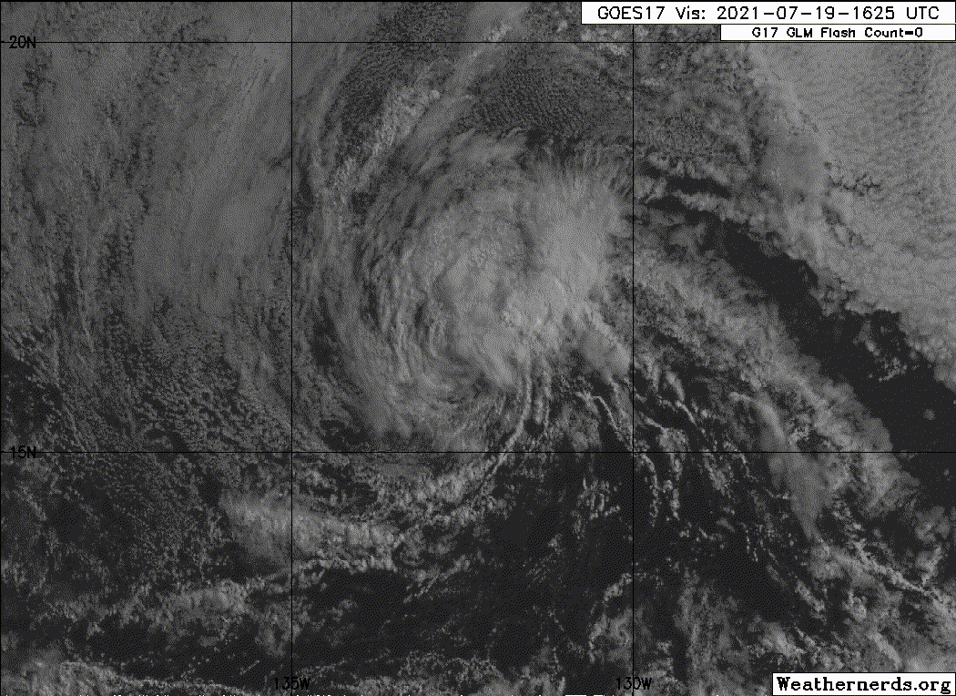
Felicia continues to rapidly weaken as it heads toward the Central
Pacific. Satellite images show a shrinking area of deep convection
that is now generally confined to the northeast quadrant of the
circulation. The Dvorak classifications continue to fall, and a
blend of the latest estimates from TAFB, SAB, and CIMSS at the
University of Wisconsin support lowering the initial intensity to
70 kt, and even that seems generous.
The weakening and very compact storm is surrounded by dry mid-level
air. This stable environment, cool 25 C SSTs, and increasing wind
shear should cause the rapid weakening trend to continue. Felicia is
forecast to weaken to a tropical storm later today and a remnant
low in a few days when it expected to be in an environment of about
40 kt of northwesterly shear and very dry air, which will likely
cause all of the deep convection to dissipate. The NHC intensity
forecast is lower than the previous one, and in line with the
majority of the latest guidance.
Felicia is moving westward at about 10 kt. A slightly faster
westward to west-southwestward motion is expected during the next
several days as Felicia, or its remnants, move in the flow on the
south side of a low- to mid-level high to its north. The NHC track
forecast is just a tad south of the previous one and lies close to
the various consensus aids. Based on the current forecast, the
weakening system is expected to cross into the Central Pacific
basin by tomorrow night.
FORECAST POSITIONS AND MAX WINDS
INIT 19/1500Z 16.3N 132.3W 70 KT 80 MPH
12H 20/0000Z 16.2N 134.0W 50 KT 60 MPH
24H 20/1200Z 16.0N 136.5W 40 KT 45 MPH
36H 21/0000Z 15.5N 139.3W 35 KT 40 MPH
48H 21/1200Z 14.9N 142.2W 30 KT 35 MPH
60H 22/0000Z 14.5N 144.7W 30 KT 35 MPH
72H 22/1200Z 14.0N 147.6W 25 KT 30 MPH...POST-TROP/REMNT LOW
96H 23/1200Z 13.6N 153.2W 25 KT 30 MPH...POST-TROP/REMNT LOW
120H 24/1200Z...DISSIPATED
$$
Forecaster Cangialosi
EPAC: FELICIA - Post-Tropical
Moderator: S2k Moderators
-
Sciencerocks
- Category 5

- Posts: 7286
- Age: 38
- Joined: Thu Jul 06, 2017 1:51 am
Re: EPAC: FELICIA - Hurricane
0 likes
-
InfernoFlameCat

- Category 5
- Posts: 1966
- Age: 21
- Joined: Mon Dec 14, 2020 10:52 am
- Location: Buford, GA
Re: EPAC: FELICIA - Hurricane
Felicia may regenerate in the west pacific however I see no model support of this.
0 likes
I am by no means a professional. DO NOT look at my forecasts for official information or make decisions based on what I post.
Goal: to become a registered expert over tropical and subtropical cyclones.
Goal: to become a registered expert over tropical and subtropical cyclones.
-
Yellow Evan

- Professional-Met

- Posts: 15952
- Age: 25
- Joined: Fri Jul 15, 2011 12:48 pm
- Location: Henderson, Nevada/Honolulu, HI
- Contact:
Re: EPAC: FELICIA - Hurricane
Very classic case of an annular storm getting blasted by westerly shear. Not unlike the 2009 version of Felicia.
2 likes
-
cycloneye

- Admin

- Posts: 139082
- Age: 67
- Joined: Thu Oct 10, 2002 10:54 am
- Location: San Juan, Puerto Rico
Re: EPAC: FELICIA - Hurricane
06E FELICIA 210719 1800 16.1N 132.8W EPAC 55 1000
0 likes
Visit the Caribbean-Central America Weather Thread where you can find at first post web cams,radars
and observations from Caribbean basin members Click Here
and observations from Caribbean basin members Click Here
-
Sciencerocks
- Category 5
- Posts: 7286
- Age: 38
- Joined: Thu Jul 06, 2017 1:51 am
-
cycloneye
- Admin
- Posts: 139082
- Age: 67
- Joined: Thu Oct 10, 2002 10:54 am
- Location: San Juan, Puerto Rico
Re: EPAC: FELICIA - Tropical Storm
Tropical Storm Felicia Discussion Number 23
NWS National Hurricane Center Miami FL EP062021
1100 AM HST Mon Jul 19 2021
Felicia continues to weaken at a rapid pace. Satellite images show
that only a small amount of deep convection in the northeastern
quadrant remains, and otherwise the circulation is largely a swirl
of low-level clouds. Dvorak classifications continue to fall, and a
blend of the latest intensity estimates from TAFB, SAB, and CIMSS at
the University of Wisconsin support lowering the initial intensity
to 55 kt. This makes Felicia a tropical storm once again. A recent
ASCAT-A pass showed peak winds close to 45 kt, but given the very
small size of the system and relatively coarse resolution of the
instrument, it seems reasonable that stronger winds are occurring.
Very dry air surrounding the small storm combined with cool SSTs
and a steady rise in northwesterly wind shear should cause
additional weakening, and Felicia will likely become a remnant low
in a couple of days, or possibly sooner if the current trends
continue. The intensity forecast follows the bulk of the guidance
and is a little lower than the previous one.
Felicia has been losing some latitude today, and the latest initial
motion estimate is 265/11 kt. A low- to mid-level ridge to the
north of the storm should steer Felicia west-southwestward to
westward during the next several days until the cyclone dissipates,
which is now expected to occur by day 4. Based on the current
forecast, Felicia should cross into the Central Pacific basin by
Tuesday night.
FORECAST POSITIONS AND MAX WINDS
INIT 19/2100Z 16.1N 133.4W 55 KT 65 MPH
12H 20/0600Z 15.9N 135.2W 45 KT 50 MPH
24H 20/1800Z 15.5N 138.0W 35 KT 40 MPH
36H 21/0600Z 15.0N 141.0W 30 KT 35 MPH
48H 21/1800Z 14.4N 143.6W 25 KT 30 MPH...POST-TROP/REMNT LOW
60H 22/0600Z 13.7N 146.2W 25 KT 30 MPH...POST-TROP/REMNT LOW
72H 22/1800Z 13.1N 148.7W 20 KT 25 MPH...POST-TROP/REMNT LOW
96H 23/1800Z...DISSIPATED
$$
Forecaster Cangialosi
0 likes
Visit the Caribbean-Central America Weather Thread where you can find at first post web cams,radars
and observations from Caribbean basin members Click Here
and observations from Caribbean basin members Click Here
-
cycloneye
- Admin
- Posts: 139082
- Age: 67
- Joined: Thu Oct 10, 2002 10:54 am
- Location: San Juan, Puerto Rico
Re: EPAC: FELICIA - Tropical Storm
Tropical Storm Felicia Discussion Number 24
NWS National Hurricane Center Miami FL EP062021
500 PM HST Mon Jul 19 2021
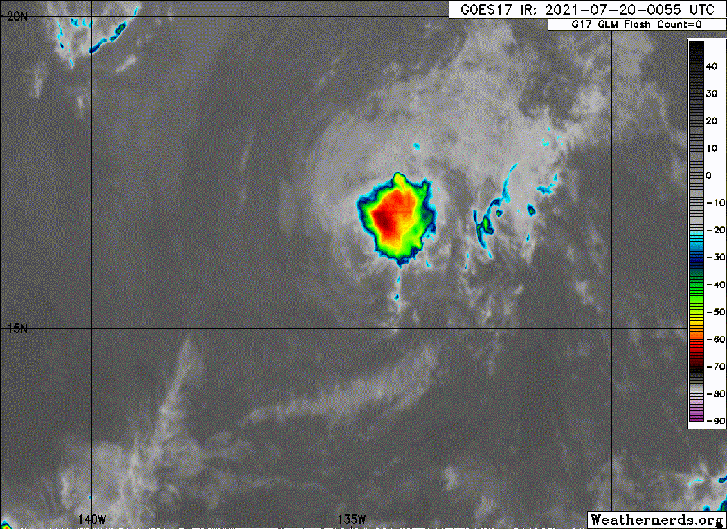
Felicia continues to rapidly weaken over sea-surface temperatures
(SST) of around 25 deg C and within a cooler and drier air mass.
After an earlier burst of strong convection, all that remains of it
is limited to the northeastern quadrant along with cloud tops now
having warmed to -55C to -60C. The latest satellite intensity
estimates from TAFB and SAB were 45 kt, and that is the intensity
assigned for this advisory. Additional weakening is forecast through
the remainder of the 72-h forecast period due to the cyclone
remaining over SSTs near 25C, westerly vertical wind shear
increasing to more than 30 kt by 24 hours, and continued entrainment
of drier and cooler low- to mid-level air. The new NHC intensity
forecast is similar to the previous advisory, and closely follows a
blend of the IVCN and HCCA intensity consensus models.
The initial motion estimate remains a little south of due west, or
265/13 kt. A low- to mid-level subtropical ridge to the north of
the cyclone is expected to steer Felicia west-southwestward to
westward over the next few days until the small cyclone dissipates
by 96 hours, if not sooner. Felicia will likely cross into the
Central Pacific basin by Tuesday night. The new official track
forecast is similar to the previous advisory track, and lies between
the tightly packed TVCE and NOAA-HCCA track forecast models.
FORECAST POSITIONS AND MAX WINDS
INIT 20/0300Z 16.1N 134.8W 45 KT 50 MPH
12H 20/1200Z 15.9N 136.7W 35 KT 40 MPH
24H 21/0000Z 15.3N 139.5W 25 KT 30 MPH
36H 21/1200Z 14.7N 142.3W 25 KT 30 MPH
48H 22/0000Z 14.2N 145.0W 20 KT 25 MPH...POST-TROP/REMNT LOW
60H 22/1200Z 13.6N 147.5W 15 KT 15 MPH...POST-TROP/REMNT LOW
72H 23/0000Z 13.0N 150.1W 15 KT 15 MPH...POST-TROP/REMNT LOW
96H 24/0000Z...DISSIPATED
$$
Forecaster Stewart
NWS National Hurricane Center Miami FL EP062021
500 PM HST Mon Jul 19 2021
Felicia continues to rapidly weaken over sea-surface temperatures
(SST) of around 25 deg C and within a cooler and drier air mass.
After an earlier burst of strong convection, all that remains of it
is limited to the northeastern quadrant along with cloud tops now
having warmed to -55C to -60C. The latest satellite intensity
estimates from TAFB and SAB were 45 kt, and that is the intensity
assigned for this advisory. Additional weakening is forecast through
the remainder of the 72-h forecast period due to the cyclone
remaining over SSTs near 25C, westerly vertical wind shear
increasing to more than 30 kt by 24 hours, and continued entrainment
of drier and cooler low- to mid-level air. The new NHC intensity
forecast is similar to the previous advisory, and closely follows a
blend of the IVCN and HCCA intensity consensus models.
The initial motion estimate remains a little south of due west, or
265/13 kt. A low- to mid-level subtropical ridge to the north of
the cyclone is expected to steer Felicia west-southwestward to
westward over the next few days until the small cyclone dissipates
by 96 hours, if not sooner. Felicia will likely cross into the
Central Pacific basin by Tuesday night. The new official track
forecast is similar to the previous advisory track, and lies between
the tightly packed TVCE and NOAA-HCCA track forecast models.
FORECAST POSITIONS AND MAX WINDS
INIT 20/0300Z 16.1N 134.8W 45 KT 50 MPH
12H 20/1200Z 15.9N 136.7W 35 KT 40 MPH
24H 21/0000Z 15.3N 139.5W 25 KT 30 MPH
36H 21/1200Z 14.7N 142.3W 25 KT 30 MPH
48H 22/0000Z 14.2N 145.0W 20 KT 25 MPH...POST-TROP/REMNT LOW
60H 22/1200Z 13.6N 147.5W 15 KT 15 MPH...POST-TROP/REMNT LOW
72H 23/0000Z 13.0N 150.1W 15 KT 15 MPH...POST-TROP/REMNT LOW
96H 24/0000Z...DISSIPATED
$$
Forecaster Stewart
0 likes
Visit the Caribbean-Central America Weather Thread where you can find at first post web cams,radars
and observations from Caribbean basin members Click Here
and observations from Caribbean basin members Click Here
-
Sciencerocks
- Category 5
- Posts: 7286
- Age: 38
- Joined: Thu Jul 06, 2017 1:51 am
-
cycloneye
- Admin
- Posts: 139082
- Age: 67
- Joined: Thu Oct 10, 2002 10:54 am
- Location: San Juan, Puerto Rico
Re: EPAC: FELICIA - Tropical Storm
Tropical Storm Felicia Discussion Number 25
NWS National Hurricane Center Miami FL EP062021
1100 PM HST Mon Jul 19 2021
Felicia is a rapidly weakening tropical cyclone. The system has been
reduced to a low- to mid-level cloud swirl in satellite imagery,
with no deep and organized convection near its center since about
0100 UTC. A couple of recent scatterometer passes show several 35-kt
vectors in the northern semicircle of the compact cyclone, which
supports lowering the initial intensity to 40 kt with this advisory.
The cyclone is moving just south of due west, or 265/13 kt. It is
expected to turn slightly more west-southwestward later today and
maintain this heading for the next several days as it is steered by
a subtropical ridge to its northwest. The NHC track forecast is
basically an update of the previous one and lies near the center of
the tightly clustered guidance envelope. Based on this forecast,
Felicia will move into the central Pacific basin by Tuesday night.
Felicia is embedded within a dry and stable airmass over SSTs of
around 25 deg C, and the cyclone will move under the influence of
strong northwesterly vertical wind shear during the next day or so.
Thus, it appears very unlikely that Felicia will be able to sustain
any organized convection near its center, even as it moves deeper
into the tropics over slightly warmer SSTs. The official NHC
intensity forecast follows the multi-model consensus and weakens
Felicia to a tropical depression in 12 h, and to a remnant low by
36 h. However, this could occur even sooner based on recent trends
and the latest model-simulated satellite imagery. The remnant low
is forecast to open up into a trough by Thursday night as it passes
well to the south of the Hawaiian Islands.
FORECAST POSITIONS AND MAX WINDS
INIT 20/0900Z 15.9N 136.3W 40 KT 45 MPH
12H 20/1800Z 15.5N 138.4W 30 KT 35 MPH
24H 21/0600Z 14.9N 141.2W 25 KT 30 MPH
36H 21/1800Z 14.3N 144.0W 25 KT 30 MPH...POST-TROP/REMNT LOW
48H 22/0600Z 13.7N 146.7W 25 KT 30 MPH...POST-TROP/REMNT LOW
60H 22/1800Z 13.2N 149.3W 20 KT 25 MPH...POST-TROP/REMNT LOW
72H 23/0600Z...DISSIPATED
$$
Forecaster Reinhart/Pasch
0 likes
Visit the Caribbean-Central America Weather Thread where you can find at first post web cams,radars
and observations from Caribbean basin members Click Here
and observations from Caribbean basin members Click Here
-
Sciencerocks
- Category 5
- Posts: 7286
- Age: 38
- Joined: Thu Jul 06, 2017 1:51 am
-
cycloneye
- Admin
- Posts: 139082
- Age: 67
- Joined: Thu Oct 10, 2002 10:54 am
- Location: San Juan, Puerto Rico
Re: EPAC: FELICIA - Tropical Storm
Tropical Storm Felicia Discussion Number 26
NWS National Hurricane Center Miami FL EP062021
500 AM HST Tue Jul 20 2021
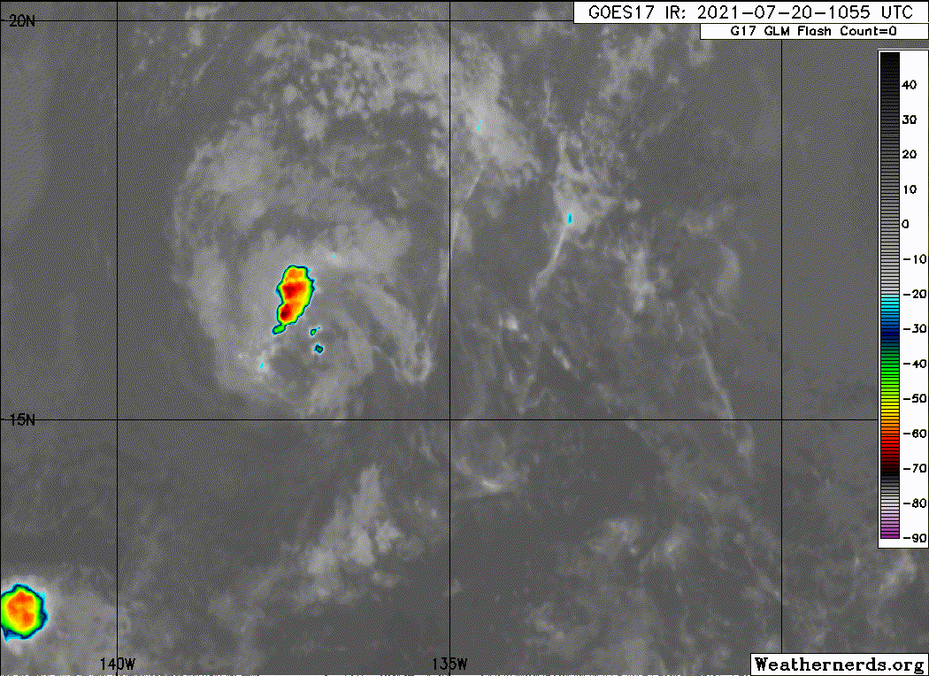
After being devoid of deep convection for 9-12 hours overnight,
Felicia managed to redevelop a small area of convection near and
north of its estimated low-level center. However, this convective
activity is poorly-organized and already appears to be waning.
Subjective Dvorak satellite estimates at 1200 UTC were T2.5/35 kt
from SAB and T2.0/30 kt from TAFB, while the latest objective ADT
estimate was T1.5/25 kt. Given the earlier scatterometer data and
that convection had increased somewhat since that time, the initial
intensity is only being lowered to a possibly generous 35 kt for
this advisory.
The latest estimated motion continues to be south of due west but a
little faster, at 260/14 kt. Felicia is primarily being steered by a
large subtropical ridge to its north, which should maintain the
cyclone on a west-southwest heading over the remainder of its
lifespan. The latest NHC track forecast remains very similar to the
previous one, but is a touch faster, in agreement with the most
recent GFS and ECMWF forecasts. On the latest forecast track,
Felicia is expected to move into the central Pacific basin later
today, just after 2100 UTC.
Despite the recent small convective burst, Felicia's large-scale
environment remains dominated by moderate to strong northwesterly
vertical wind shear within a dry and stable airmass over 25-26 C
sea-surface temperatures. Consequently, a good chunk of the
deterministic model guidance (e.g., GFS/ECWMF/HWRF) depict Felicia
struggling to produce much, if any, additional organized convection
near its center. The official NHC intensity forecast shows Felicia
weakening into a tropical depression later today and then
degenerating into a remnant low by 24 hours, in close agreement with
the multi-model consensus. The remnant low is then forecast to open
up into a trough while moving well south of the Hawaiian islands by
60 hours.
FORECAST POSITIONS AND MAX WINDS
INIT 20/1500Z 15.8N 138.0W 35 KT 40 MPH
12H 21/0000Z 15.3N 140.2W 30 KT 35 MPH
24H 21/1200Z 14.7N 143.1W 25 KT 30 MPH...POST-TROP/REMNT LOW
36H 22/0000Z 14.1N 145.9W 25 KT 30 MPH...POST-TROP/REMNT LOW
48H 22/1200Z 13.6N 148.7W 25 KT 30 MPH...POST-TROP/REMNT LOW
60H 23/0000Z...DISSIPATED
$$
Forecaster Papin/Cangialosi
NWS National Hurricane Center Miami FL EP062021
500 AM HST Tue Jul 20 2021
After being devoid of deep convection for 9-12 hours overnight,
Felicia managed to redevelop a small area of convection near and
north of its estimated low-level center. However, this convective
activity is poorly-organized and already appears to be waning.
Subjective Dvorak satellite estimates at 1200 UTC were T2.5/35 kt
from SAB and T2.0/30 kt from TAFB, while the latest objective ADT
estimate was T1.5/25 kt. Given the earlier scatterometer data and
that convection had increased somewhat since that time, the initial
intensity is only being lowered to a possibly generous 35 kt for
this advisory.
The latest estimated motion continues to be south of due west but a
little faster, at 260/14 kt. Felicia is primarily being steered by a
large subtropical ridge to its north, which should maintain the
cyclone on a west-southwest heading over the remainder of its
lifespan. The latest NHC track forecast remains very similar to the
previous one, but is a touch faster, in agreement with the most
recent GFS and ECMWF forecasts. On the latest forecast track,
Felicia is expected to move into the central Pacific basin later
today, just after 2100 UTC.
Despite the recent small convective burst, Felicia's large-scale
environment remains dominated by moderate to strong northwesterly
vertical wind shear within a dry and stable airmass over 25-26 C
sea-surface temperatures. Consequently, a good chunk of the
deterministic model guidance (e.g., GFS/ECWMF/HWRF) depict Felicia
struggling to produce much, if any, additional organized convection
near its center. The official NHC intensity forecast shows Felicia
weakening into a tropical depression later today and then
degenerating into a remnant low by 24 hours, in close agreement with
the multi-model consensus. The remnant low is then forecast to open
up into a trough while moving well south of the Hawaiian islands by
60 hours.
FORECAST POSITIONS AND MAX WINDS
INIT 20/1500Z 15.8N 138.0W 35 KT 40 MPH
12H 21/0000Z 15.3N 140.2W 30 KT 35 MPH
24H 21/1200Z 14.7N 143.1W 25 KT 30 MPH...POST-TROP/REMNT LOW
36H 22/0000Z 14.1N 145.9W 25 KT 30 MPH...POST-TROP/REMNT LOW
48H 22/1200Z 13.6N 148.7W 25 KT 30 MPH...POST-TROP/REMNT LOW
60H 23/0000Z...DISSIPATED
$$
Forecaster Papin/Cangialosi
0 likes
Visit the Caribbean-Central America Weather Thread where you can find at first post web cams,radars
and observations from Caribbean basin members Click Here
and observations from Caribbean basin members Click Here
-
cycloneye
- Admin
- Posts: 139082
- Age: 67
- Joined: Thu Oct 10, 2002 10:54 am
- Location: San Juan, Puerto Rico
Re: EPAC: FELICIA - Tropical Depression
Tropical Depression Felicia Discussion Number 27
NWS National Hurricane Center Miami FL EP062021
1100 AM HST Tue Jul 20 2021
Convection once again has mostly dissipated near the low-level
circulation of Felicia. Without any organized deep convection, the
clock is now ticking on its remaining lifespan as a tropical
cyclone. An ASCAT-A scatterometer pass that was recently received at
1709 UTC had a peak wind retrieval of 32-kt just north of the
center. Given the lack of convection since that time, as well as the
latest Dvorak estimates decreasing further, Felicia is being
downgraded to a tropical depression at this time with maximum
sustained winds of 30 kt. Further weakening is anticipated as
Felicia remains in a very dry, stable environment. The depression
is forecast to degenerate into a remnant low in the next 12 hours
and open up into a trough by the end of the week, well south of
Hawaii.
The latest estimated motion is now to the west-southwest at 255/14
kt. The track philosophy has changed little this advisory as a large
subtropical ridge will continue to steer Felicia to the
west-southwest over the last few days of its life. The latest NHC
track forecast is largely an update of the previous forecast track
as the guidance remains tightly clustered along the forecast track.
On this track, Felicia will be crossing into the central Pacific
basin within the next few hours.
This is the last advisory issued by the National Hurricane Center
on Felicia. Future information on this system can be found in
Forecast/Advisories issued by the Central Pacific Hurricane Center
beginning at 0300 UTC...under AWIPS header HFOTCMCP1 ...WMO header
WTPA21 PHFO.
FORECAST POSITIONS AND MAX WINDS
INIT 20/2100Z 15.3N 139.4W 30 KT 35 MPH
12H 21/0600Z 14.8N 141.6W 25 KT 30 MPH...POST-TROP/REMNT LOW
24H 21/1800Z 14.3N 144.4W 25 KT 30 MPH...POST-TROP/REMNT LOW
36H 22/0600Z 13.7N 147.3W 25 KT 30 MPH...POST-TROP/REMNT LOW
48H 22/1800Z 13.2N 150.0W 25 KT 30 MPH...POST-TROP/REMNT LOW
60H 23/0600Z...DISSIPATED
$$
Forecaster Papin/Cangialosi
0 likes
Visit the Caribbean-Central America Weather Thread where you can find at first post web cams,radars
and observations from Caribbean basin members Click Here
and observations from Caribbean basin members Click Here
-
cycloneye
- Admin
- Posts: 139082
- Age: 67
- Joined: Thu Oct 10, 2002 10:54 am
- Location: San Juan, Puerto Rico
Re: EPAC: FELICIA - Tropical Depression
EP, 06, 2021072100, , BEST, 0, 151N, 1401W, 30, 1008, LO

6 likes
Visit the Caribbean-Central America Weather Thread where you can find at first post web cams,radars
and observations from Caribbean basin members Click Here
and observations from Caribbean basin members Click Here
-
ElectricStorm

- Category 5
- Posts: 4545
- Age: 23
- Joined: Tue Aug 13, 2019 11:23 pm
- Location: Skiatook, OK / Norman, OK
Re: EPAC: FELICIA - Tropical Depression
Looks like Felicia's done. What a great storm. Now the question is can the EPAC produce a storm to beat it? The Atlantic will probably take over during peak season, so the EPAC has about a month or so to hopefully pump out some decent storms. See you in 2027 Felicia!
3 likes
I am in no way a professional. Take what I say with a grain of salt as I could be totally wrong. Please refer to the NHC, NWS, or SPC for official information.
Boomer Sooner!
Boomer Sooner!
-
cycloneye
- Admin
- Posts: 139082
- Age: 67
- Joined: Thu Oct 10, 2002 10:54 am
- Location: San Juan, Puerto Rico
Re: EPAC: FELICIA - Post-Tropical
Post-Tropical Cyclone Felicia Discussion Number 28
NWS Central Pacific Hurricane Center Honolulu HI EP062021
500 PM HST Tue Jul 20 2021
A small area of deep convection that flared up early this morning
has dissipated. Since then, what's left of Felicia is just a low
cloud swirl moving within the trade wind flow, with thin high clouds
moving over it from the west. The initial motion is 255/14 kt.
Felicia is moving in a hostile environment, with dry, stable
conditions, vertical wind shear greater than 20 kt, and sea
surface temperatures around 25 to 26C. While there may be isolated
flare-ups of deep convection over the next couple of days,
reintensification under these conditions is not likely. Thus,
Felicia has been declared a post-tropical remnant low. The remnant
circulation of Felicia should continue to spin down and the global
models open up the circulation into a trough by the end of the week.
This is the last advisory issued by the Central Pacific Hurricane
Center on Felicia. Additional information on this system can be
found in the High Seas Forecasts issued by the National Weather
Service in Honolulu under AWIPS header HFOHSFNP and WMO header
FZPN40 PHFO.
FORECAST POSITIONS AND MAX WINDS
INIT 21/0300Z 14.9N 140.9W 30 KT 35 MPH...POST-TROP/REMNT LOW
12H 21/1200Z 14.5N 143.0W 25 KT 30 MPH...POST-TROP/REMNT LOW
24H 22/0000Z 13.9N 145.7W 25 KT 30 MPH...POST-TROP/REMNT LOW
36H 22/1200Z 13.3N 148.5W 25 KT 30 MPH...POST-TROP/REMNT LOW
48H 23/0000Z 13.0N 151.4W 25 KT 30 MPH...POST-TROP/REMNT LOW
60H 23/1200Z...DISSIPATED
$$
Forecaster Kodama
0 likes
Visit the Caribbean-Central America Weather Thread where you can find at first post web cams,radars
and observations from Caribbean basin members Click Here
and observations from Caribbean basin members Click Here
-
galaxy401

- Category 5
- Posts: 2299
- Age: 28
- Joined: Sat Aug 25, 2012 9:04 pm
- Location: Casa Grande, Arizona
Re: EPAC: FELICIA - Post-Tropical
Gave the CPHC a little bit of work to do...for just one advisory. Has there been other storms that crossed over to the CPAC only to immediately become a remnant low?
1 likes
Got my eyes on moving right into Hurricane Alley: Florida.
-
Astromanía
- Category 2

- Posts: 737
- Age: 25
- Joined: Sat Aug 25, 2018 10:34 pm
- Location: Monterrey, N.L, México
-
Yellow Evan
- Professional-Met
- Posts: 15952
- Age: 25
- Joined: Fri Jul 15, 2011 12:48 pm
- Location: Henderson, Nevada/Honolulu, HI
- Contact:
Re: EPAC: FELICIA - Post-Tropical
galaxy401 wrote:Gave the CPHC a little bit of work to do...for just one advisory. Has there been other storms that crossed over to the CPAC only to immediately become a remnant low?
Daniel 2012.
0 likes
Who is online
Users browsing this forum: No registered users and 71 guests