EPAC: FELICIA - Post-Tropical

Moderator: S2k Moderators

Message
Author
User avatar
Teban54
Category 5
Category 5
Posts: 1960
Joined: Sat May 19, 2018 1:19 pm

Re: EPAC: FELICIA - Hurricane

#461 Postby Teban54 » Sun Jul 18, 2021 3:07 am

Shell Mound wrote:This looks more impressive than any Atlantic hurricane since Wilma (2005), and that says a lot about the +AMO (or lack thereof). Cloud tops are colder and the eye warmer than in, among others, Matthew (2016), Irma/Jose (2017), Michael (2018), and Dorian (2019), especially when the compact circulation and wind radii are taken into account. Its appearance notwithstanding, Eta was not very impressive, based on the existence of shear, whereas Felicia is not sheared. I shall reiterate: Felicia was rather clearly 145–150 kt yesterday and is almost certainly matching those MSW currently. This system is a solid Cat-5 and the artificially low satellite-based estimates should be discarded.


While I do think Felicia might have been underestimated, such analysis using only cloud tops and eye temperature can be misleading. Dorian and Eta are two examples on the opposite ends of the spectrum.
11 likes   

User avatar
Yellow Evan
Professional-Met
Professional-Met
Posts: 15954
Age: 25
Joined: Fri Jul 15, 2011 12:48 pm
Location: Henderson, Nevada/Honolulu, HI
Contact:

Re: EPAC: FELICIA - Hurricane

#462 Postby Yellow Evan » Sun Jul 18, 2021 3:08 am

----- Current Analysis -----
Date : 18 JUL 2021 Time : 072031 UTC
Lat : 15:21:35 N Lon : 126:49:48 W


CI# /Pressure/ Vmax
5.4 / 963.4mb/ 99.6kt


Final T# Adj T# Raw T#
5.4 5.7 5.7

Estimated radius of max. wind based on IR : 13 km

Center Temp : +17.8C Cloud Region Temp : -60.1C

Scene Type : EYE


Slowly fixing itself.
0 likes   

User avatar
Kingarabian
S2K Supporter
S2K Supporter
Posts: 15439
Joined: Sat Aug 08, 2009 3:06 am
Location: Honolulu, Hawaii

Re: EPAC: FELICIA - Hurricane

#463 Postby Kingarabian » Sun Jul 18, 2021 3:09 am

Shell Mound wrote:This looks more impressive than any Atlantic hurricane since Wilma (2005), and that says a lot about the +AMO (or lack thereof). Cloud tops are colder and the eye warmer than in, among others, Matthew (2016), Irma/Jose (2017), Michael (2018), and Dorian (2019), especially when the compact circulation and wind radii are taken into account. Its appearance notwithstanding, Eta was not very impressive, based on the existence of shear, whereas Felicia is not sheared. I shall reiterate: Felicia was rather clearly 145–150 kt yesterday and is almost certainly matching those MSW currently. This system is a solid Cat-5 and the artificially low satellite-based estimates should be discarded.

Dude?
9 likes   
RIP Kobe Bryant

User avatar
cycloneye
Admin
Admin
Posts: 139151
Age: 67
Joined: Thu Oct 10, 2002 10:54 am
Location: San Juan, Puerto Rico

Re: EPAC: FELICIA - Hurricane

#464 Postby cycloneye » Sun Jul 18, 2021 4:18 am

Hurricane Felicia Discussion Number 17
NWS National Hurricane Center Miami FL EP062021
1100 PM HST Sat Jul 17 2021

Felicia has maintained its impressive structure tonight, with a
symmetric ring of very cold infrared cloud-top temperatures
surrounding a warm and well-defined eye. Recent microwave imagery
shows that Felicia still has a very compact inner core. The initial
intensity is maintained at 120 kt, as the hurricane's satellite
appearance has shown no signs of decay since the last advisory. This
intensity is consistent with subjective T6.0 Dvorak classifications
from TAFB and SAB.

Felicia should weaken during the next couple of days as the
hurricane moves over cooler sea-surface temperatures, although this
could be a gradual process while the vertical wind shear remains
low. By Tuesday, increasing northwesterly wind shear in a drier,
more stable environment is expected to accelerate the weakening of
Felicia through the middle and latter parts of the week. Although
the official NHC forecast shows remnant low status by day 5, it is
plausible that this could occur even sooner if the higher shear
values in the ECMWF SHIPS guidance materialize. The official NHC
intensity forecast lies above the guidance model consensus through
48 h, then aligns with the HFIP corrected consensus approach (HCCA)
aid through the rest of the forecast period.

Felicia is still moving west-northwestward at about 9 kt. The track
guidance has been quite consistent and remains in very good
agreement, which makes for a high confidence track forecast. The
cyclone is expected to turn more westward by Monday, then move
west-southwestward through midweek as Felicia becomes steered by an
expansive ridge across the central Pacific. The NHC track forecast
is essentially unchanged from the previous one and lies between the
reliable consensus aids TVCE and HCCA.


FORECAST POSITIONS AND MAX WINDS

INIT 18/0900Z 15.5N 127.1W 120 KT 140 MPH
12H 18/1800Z 15.8N 128.5W 115 KT 130 MPH
24H 19/0600Z 16.1N 130.6W 100 KT 115 MPH
36H 19/1800Z 16.3N 132.7W 85 KT 100 MPH
48H 20/0600Z 16.2N 134.9W 75 KT 85 MPH
60H 20/1800Z 15.9N 137.4W 60 KT 70 MPH
72H 21/0600Z 15.3N 140.1W 50 KT 60 MPH
96H 22/0600Z 14.3N 145.5W 35 KT 40 MPH
120H 23/0600Z 13.5N 151.0W 30 KT 35 MPH...POST-TROP/REMNT LOW

$$
Forecaster Reinhart/Pasch
0 likes   
Visit the Caribbean-Central America Weather Thread where you can find at first post web cams,radars
and observations from Caribbean basin members Click Here

User avatar
aspen
Category 5
Category 5
Posts: 8057
Joined: Sat Oct 12, 2019 7:10 pm
Location: Connecticut, USA

Re: EPAC: FELICIA - Hurricane

#465 Postby aspen » Sun Jul 18, 2021 4:38 am

It’s moving over cooler waters and yet still refuses to die. The HWRF might’ve underestimated intensity in a first for an initial invest run, but it did correctly predict an annular structure and Felicia’s tenacity.
5 likes   
Irene '11 Sandy '12 Hermine '16 5/15/2018 Derecho Fay '20 Isaias '20 Elsa '21 Henri '21 Ida '21

I am only a meteorology enthusiast who knows a decent amount about tropical cyclones. Look to the professional mets, the NHC, or your local weather office for the best information.

User avatar
InfernoFlameCat
Category 5
Category 5
Posts: 1966
Age: 21
Joined: Mon Dec 14, 2020 10:52 am
Location: Buford, GA

Re: EPAC: FELICIA - Hurricane

#466 Postby InfernoFlameCat » Sun Jul 18, 2021 5:34 am

Felicia at this rate is going to be a cat4 over artic waters :lol:
0 likes   
I am by no means a professional. DO NOT look at my forecasts for official information or make decisions based on what I post.

Goal: to become a registered expert over tropical and subtropical cyclones.

User avatar
Kingarabian
S2K Supporter
S2K Supporter
Posts: 15439
Joined: Sat Aug 08, 2009 3:06 am
Location: Honolulu, Hawaii

Re: EPAC: FELICIA - Hurricane

#467 Postby Kingarabian » Sun Jul 18, 2021 5:40 am

Global models + HWRF/HMON putting a lot of stock in 7-10kts of westerly mid shear quickly breaking apart Felicia... although its with the help of dry air.
Image

* GFS version *
* EAST PACIFIC 2021 SHIPS INTENSITY FORECAST *
* IR SAT DATA AVAILABLE, OHC AVAILABLE *
* FELICIA EP062021 07/18/21 06 UTC *

TIME (HR) 0 6 12 18 24 36 48 60 72 84 96 108 120 132 144 156 168
V (KT) NO LAND 120 113 105 98 93 82 71 60 49 37 28 23 20 19 19 23 25
V (KT) LAND 120 113 105 98 93 82 71 60 49 37 28 23 20 19 19 23 25
V (KT) LGEM 120 111 102 93 86 74 65 57 50 42 36 30 25 21 17 N/A N/A
Storm Type TROP TROP TROP TROP TROP TROP TROP TROP TROP TROP TROP TROP TROP TROP TROP N/A N/A

SHEAR (KT) 7 6 5 2 1 4 5 8 14 31 39 33 27 29 35 N/A N/A
SHEAR ADJ (KT) -3 -2 0 2 2 2 1 0 1 -2 -8 -2 1 0 0 N/A N/A
SHEAR DIR 345 344 346 34 128 149 177 224 296 306 311 306 294 291 277 N/A N/A
SST (C) 26.4 26.2 25.9 25.8 25.8 26.0 25.1 25.1 24.8 25.4 25.5 26.4 26.4 26.2 26.5 N/A N/A
POT. INT. (KT) 127 125 122 121 121 124 115 115 112 119 119 128 129 128 131 N/A N/A
200 MB T (C) -52.5 -52.6 -52.4 -52.1 -51.9 -52.2 -52.3 -52.7 -53.0 -53.5 -53.2 -53.5 -53.5 -53.7 -53.4 N/A N/A
200 MB VXT (C) 0.2 0.3 0.5 0.5 0.5 0.8 0.6 0.6 0.5 0.0 0.0 0.0 -0.1 -0.1 -0.1 N/A N/A
TH_E DEV (C) 5 4 4 4 4 3 3 3 4 4 5 4 5 5 6 N/A N/A
700-500 MB RH 46 48 48 48 48 49 46 42 39 39 41 46 49 53 54 N/A N/A
MODEL VTX (KT) 18 17 17 16 16 15 13 13 11 10 9 8 7 6 4 LOST LOST
850 MB ENV VOR -7 -9 -22 -33 -27 -18 -4 6 15 16 24 22 21 7 -7 N/A N/A
200 MB DIV -12 -11 -18 -13 -9 -46 -20 -29 -43 -46 -2 0 -19 -29 -27 N/A N/A
700-850 TADV -4 -3 -2 0 0 3 2 6 5 2 1 2 2 3 -2 N/A N/A
LAND (KM) 1828 1875 1920 1989 2060 2218 2136 1884 1637 1367 1111 913 776 656 713 N/A N/A
LAT (DEG N) 15.3 15.6 15.9 16.1 16.2 16.3 16.2 15.9 15.3 14.8 14.4 14.0 13.7 xx.x xx.x N/A N/A
LONG(DEG W) 126.6 127.6 128.5 129.5 130.6 132.6 134.9 137.4 140.0 142.9 145.8 148.4 150.7 xxx.x xxx.x N/A N/A
STM SPEED (KT) 9 10 9 10 10 11 12 12 14 14 13 12 14 16 17 N/A N/A
HEAT CONTENT 1 0 0 0 0 0 0 0 0 0 0 3 4 0 4 N/A N/A

FORECAST TRACK FROM OFCI INITIAL HEADING/SPEED (DEG/KT):290/ 8 CX,CY: -7/ 3
T-12 MAX WIND: 125 PRESSURE OF STEERING LEVEL (MB): 604 (MEAN=587)
GOES IR BRIGHTNESS TEMP. STD DEV. 50-200 KM RAD: 11.5 (MEAN=14.5)
% GOES IR PIXELS WITH T < -20 C 50-200 KM RAD: 68.0 (MEAN=65.0)
PRELIM RI PROB (DV .GE. 35 KT IN 36 HR): 0.0

INDIVIDUAL CONTRIBUTIONS TO INTENSITY CHANGE
6 12 18 24 36 48 60 72 84 96 108 120 132 144 156 168
------------------------------------------------------------------------------
SAMPLE MEAN CHANGE 0. 0. 1. 1. 1. 2. 1. 1. 0. -0. -1. -2. -2. -3. -4. -4.
SST POTENTIAL -3. -7. -11. -16. -24. -34. -44. -52. -60. -65. -69. -70. -71. -72. -75. -79.
VERTICAL SHEAR MAG -1. -1. -1. 0. 2. 3. 5. 6. 6. 4. 1. -2. -4. -5. -1. 1.
VERTICAL SHEAR ADJ 0. 0. 0. 0. -0. -0. -0. -0. -0. 0. 0. 0. 0. 0. 0. 0.
VERTICAL SHEAR DIR -0. -0. -0. 0. -0. -0. -2. -3. -4. -5. -5. -6. -6. -6. -5. -5.
PERSISTENCE -2. -2. -2. -2. -2. -1. 0. 1. 1. 1. 1. 1. 1. 1. 1. 1.
200/250 MB TEMP. -0. -0. -0. -0. -0. 0. 1. 1. 1. 1. 1. 0. 0. 0. 0. 0.
THETA_E EXCESS -0. -0. -1. -1. -3. -4. -5. -6. -6. -6. -6. -6. -6. -6. -7. -8.
700-500 MB RH -0. -0. -0. -1. -1. -1. -1. -2. -2. -2. -2. -2. -2. -3. -4. -5.
MODEL VTX TENDENCY -0. -0. -1. -1. -2. -4. -6. -9. -11. -13. -13. -13. -13. -13. -12. -11.
850 MB ENV VORTICITY -0. -0. -0. -0. -0. 0. 0. 1. 1. 1. 1. 1. 1. 1. 1. 1.
200 MB DIVERGENCE -0. -1. -1. -1. -2. -3. -4. -6. -7. -7. -7. -5. -3. -1. 1. 2.
850-700 T ADVEC 0. 0. 0. 0. -0. 0. 0. 0. 0. 0. 0. 0. 0. 1. 1. 1.
ZONAL STORM MOTION 0. 0. 0. 0. 0. -0. -0. -0. -0. -0. -0. -0. -0. -0. -0. 0.
STEERING LEVEL PRES 0. 0. 0. 0. 0. 0. 0. 0. 1. 1. 1. 1. 0. 0. 0. 0.
DAYS FROM CLIM. PEAK -0. -0. -0. -0. -0. -0. -0. -1. -1. -1. -1. -1. -2. -2. -2. -3.
GOES PREDICTORS -1. -2. -3. -3. -3. -2. -2. -1. -1. -1. -1. -2. -1. -0. 0. 2.
OCEAN HEAT CONTENT -0. -0. -0. -0. -0. -1. -2. -1. -1. -0. 0. 1. 2. 3. 4. 6.
RI POTENTIAL -0. -1. -2. -3. -4. -5. -3. -1. 1. 2. 4. 4. 5. 5. 4. 4.
------------------------------------------------------------------------------
TOTAL CHANGE -7. -15. -22. -27. -38. -49. -60. -71. -83. -92. -97.-100.-101.-101. -97. -95.

CURRENT MAX WIND (KT): 120. LAT, LON: 15.3 126.6

** 2021 E. Pacific RI INDEX EP062021 FELICIA 07/18/21 06 UTC **
(SHIPS-RII PREDICTOR TABLE for 30 KT OR MORE MAXIMUM WIND INCREASE IN NEXT 24-h)

Predictor Value RI Predictor Range Scaled Value(0-1) % Contribution
POT = MPI-VMAX (KT) : 3.5 40.5 to 149.3 0.00 0.0
12 HR PERSISTENCE (KT) : -5.0 -22.0 to 44.0 0.26 999.0
D200 (10**7s-1) : -12.6 -33.0 to 159.5 0.11 999.0
850-200 MB SHEAR (KT) : 4.2 19.6 to 1.3 0.84 999.0
MAXIMUM WIND (KT) : 120.0 22.5 to 132.0 0.16 999.0
STD DEV OF IR BR TEMP : 11.5 37.8 to 2.1 0.74 999.0
BL DRY-AIR FLUX (W/M2) : 872.0 800.8 to -82.5 0.00 0.0
HEAT CONTENT (KJ/CM2) : 0.2 2.7 to 106.7 0.00 0.0
%area of TPW <45 mm upshear : 0.0 56.6 to 0.0 1.00 999.0
2nd PC OF IR BR TEMP : 0.0 2.2 to -2.3 0.48 999.0

SHIPS Prob RI for 20kt/ 12hr RI threshold= 0% is 0.0 times climatological mean ( 6.3%)
SHIPS Prob RI for 25kt/ 24hr RI threshold= 0% is 0.0 times climatological mean (12.5%)
SHIPS Prob RI for 30kt/ 24hr RI threshold= 0% is 0.0 times climatological mean ( 8.6%)
SHIPS Prob RI for 35kt/ 24hr RI threshold= 0% is 0.0 times climatological mean ( 6.2%)
SHIPS Prob RI for 40kt/ 24hr RI threshold= 0% is 0.0 times climatological mean ( 4.2%)
SHIPS Prob RI for 45kt/ 36hr RI threshold= 0% is 0.0 times climatological mean ( 6.7%)
SHIPS Prob RI for 55kt/ 48hr RI threshold= 0% is 0.0 times climatological mean ( 5.9%)
SHIPS Prob RI for 65kt/ 72hr RI threshold= 0% is 0.0 times climatological mean ( 4.7%)

Matrix of RI probabilities
------------------------------------------------------------------------------
RI (kt / h) | 20/12 | 25/24 | 30/24 | 35/24 | 40/24 | 45/36 | 55/48 |65/72
------------------------------------------------------------------------------
SHIPS-RII: 0.0% 0.0% 0.0% 0.0% 0.0% 0.0% 0.0% 0.0%
Logistic: 0.5% 0.7% 1.0% 0.5% 0.6% 0.0% 0.0% 0.0%
Bayesian: 0.0% 0.0% 0.0% 0.0% 0.0% 0.0% 0.0% 0.0%
Consensus: 0.2% 0.2% 0.3% 0.2% 0.2% 0.0% 0.0% 0.0%
DTOPS: 0.0% 0.0% 0.0% 0.0% 0.0% 0.0% 0.0% 0.0%

## ANNULAR HURRICANE INDEX (AHI) EP062021 FELICIA 07/18/21 06 UTC ##
## STORM NOT ANNULAR, SCREENING STEP FAILED, NPASS=5 NFAIL=2 ##
## AHI= 0 (AHI OF 100 IS BEST FIT TO ANN. STRUC., 1 IS MARGINAL, 0 IS NOT ANNULAR) ##
Last edited by Kingarabian on Sun Jul 18, 2021 5:46 am, edited 1 time in total.
0 likes   
RIP Kobe Bryant

User avatar
Kingarabian
S2K Supporter
S2K Supporter
Posts: 15439
Joined: Sat Aug 08, 2009 3:06 am
Location: Honolulu, Hawaii

Re: EPAC: FELICIA - Hurricane

#468 Postby Kingarabian » Sun Jul 18, 2021 5:43 am

Mini buzzsaw:
Image
7 likes   
RIP Kobe Bryant

User avatar
Kingarabian
S2K Supporter
S2K Supporter
Posts: 15439
Joined: Sat Aug 08, 2009 3:06 am
Location: Honolulu, Hawaii

Re: EPAC: FELICIA - Hurricane

#469 Postby Kingarabian » Sun Jul 18, 2021 5:57 am

UW - CIMSS
ADVANCED DVORAK TECHNIQUE
ADT-Version 9.0
Tropical Cyclone Intensity Algorithm

----- Current Analysis -----
Date : 18 JUL 2021 Time : 102032 UTC
Lat : 15:32:23 N Lon : 127:17:24 W


CI# /Pressure/ Vmax
5.8 / 955.0mb/109.8kt


Final T# Adj T# Raw T#
5.8 5.8 5.8

Estimated radius of max. wind based on IR : 13 km

Center Temp : +18.9C Cloud Region Temp : -61.9C

Scene Type : EYE

Subtropical Adjustment : OFF

Extratropical Adjustment : OFF

Positioning Method : ARCHER POSITIONING

Ocean Basin : EAST PACIFIC
Dvorak CI > MSLP Conversion Used : CKZ Method


Tno/CI Rules : Constraint Limits : NO LIMIT
Weakening Flag : OFF
Rapid Dissipation Flag : OFF


Image
Last edited by Kingarabian on Sun Jul 18, 2021 5:57 am, edited 1 time in total.
0 likes   
RIP Kobe Bryant

User avatar
InfernoFlameCat
Category 5
Category 5
Posts: 1966
Age: 21
Joined: Mon Dec 14, 2020 10:52 am
Location: Buford, GA

Re: EPAC: INVEST 96E

#470 Postby InfernoFlameCat » Sun Jul 18, 2021 5:57 am

Kingarabian wrote:18z HWRF. Simply to come back and look at it when it busts.
https://i.imgur.com/v6erMFZ.gif

It makes it annular for a while so it's not that crazy though.

It busted the wrong way
1 likes   
I am by no means a professional. DO NOT look at my forecasts for official information or make decisions based on what I post.

Goal: to become a registered expert over tropical and subtropical cyclones.

User avatar
toad strangler
S2K Supporter
S2K Supporter
Posts: 4163
Joined: Sun Jul 28, 2013 3:09 pm
Location: Earth
Contact:

Re: EPAC: FELICIA - Hurricane

#471 Postby toad strangler » Sun Jul 18, 2021 7:12 am

2 likes   

User avatar
cycloneye
Admin
Admin
Posts: 139151
Age: 67
Joined: Thu Oct 10, 2002 10:54 am
Location: San Juan, Puerto Rico

Re: EPAC: FELICIA - Hurricane

#472 Postby cycloneye » Sun Jul 18, 2021 7:43 am

EP, 06, 2021071812, , BEST, 0, 156N, 1276W, 115, 954, HU
0 likes   
Visit the Caribbean-Central America Weather Thread where you can find at first post web cams,radars
and observations from Caribbean basin members Click Here

User avatar
ElectricStorm
Category 5
Category 5
Posts: 4573
Age: 23
Joined: Tue Aug 13, 2019 11:23 pm
Location: Skiatook, OK / Norman, OK

Re: EPAC: FELICIA - Hurricane

#473 Postby ElectricStorm » Sun Jul 18, 2021 8:45 am

Shell Mound wrote:This looks more impressive than any Atlantic hurricane since Wilma (2005), and that says a lot about the +AMO (or lack thereof). Cloud tops are colder and the eye warmer than in, among others, Matthew (2016), Irma/Jose (2017), Michael (2018), and Dorian (2019), especially when the compact circulation and wind radii are taken into account. Its appearance notwithstanding, Eta was not very impressive, based on the existence of shear, whereas Felicia is not sheared. I shall reiterate: Felicia was rather clearly 145–150 kt yesterday and is almost certainly matching those MSW currently. This system is a solid Cat-5 and the artificially low satellite-based estimates should be discarded.

Bruh... You're kidding right? There's been several Atlantic storms that have looked better than Felicia since Wilma...
As for Felicia, it was definitely 130-140kts yesterday, but NHC isn't going to upgrade to Cat 5 on a borderline case with no solid evidence. There's no reason to, especially since it's out in the middle of nowhere. Could end up being a solid case study though...
4 likes   
I am in no way a professional. Take what I say with a grain of salt as I could be totally wrong. Please refer to the NHC, NWS, or SPC for official information.

Boomer Sooner!

User avatar
Yellow Evan
Professional-Met
Professional-Met
Posts: 15954
Age: 25
Joined: Fri Jul 15, 2011 12:48 pm
Location: Henderson, Nevada/Honolulu, HI
Contact:

Re: EPAC: FELICIA - Hurricane

#474 Postby Yellow Evan » Sun Jul 18, 2021 9:05 am

0 likes   

User avatar
cheezyWXguy
Category 5
Category 5
Posts: 5537
Joined: Mon Feb 13, 2006 12:29 am
Location: Dallas, TX

Re: EPAC: FELICIA - Hurricane

#475 Postby cheezyWXguy » Sun Jul 18, 2021 9:07 am

Weather Dude wrote:
Shell Mound wrote:This looks more impressive than any Atlantic hurricane since Wilma (2005), and that says a lot about the +AMO (or lack thereof). Cloud tops are colder and the eye warmer than in, among others, Matthew (2016), Irma/Jose (2017), Michael (2018), and Dorian (2019), especially when the compact circulation and wind radii are taken into account. Its appearance notwithstanding, Eta was not very impressive, based on the existence of shear, whereas Felicia is not sheared. I shall reiterate: Felicia was rather clearly 145–150 kt yesterday and is almost certainly matching those MSW currently. This system is a solid Cat-5 and the artificially low satellite-based estimates should be discarded.

Bruh... You're kidding right? There's been several Atlantic storms that have looked better than Felicia since Wilma...
As for Felicia, it was definitely 130-140kts yesterday, but NHC isn't going to upgrade to Cat 5 on a borderline case with no solid evidence. There's no reason to, especially since it's out in the middle of nowhere. Could end up being a solid case study though...

Agreed, and if we are going off of looks alone, I would say Eta was more impressive than Wilma while maintaining a similar structure. Didn’t it have like an instantaneous adt of 8.4? Inb4 I’m aware instantaneous readings are not a valid measure of true intensity.

If we are comparing Felicia to only annular Atlantic hurricanes though, in my book it’s comparable only to Isabel
1 likes   

User avatar
Yellow Evan
Professional-Met
Professional-Met
Posts: 15954
Age: 25
Joined: Fri Jul 15, 2011 12:48 pm
Location: Henderson, Nevada/Honolulu, HI
Contact:

Re: EPAC: FELICIA - Hurricane

#476 Postby Yellow Evan » Sun Jul 18, 2021 9:28 am

0 likes   

Sciencerocks
Category 5
Category 5
Posts: 7287
Age: 38
Joined: Thu Jul 06, 2017 1:51 am

Re: EPAC: FELICIA - Hurricane

#477 Postby Sciencerocks » Sun Jul 18, 2021 9:30 am

Image
1 likes   

User avatar
Yellow Evan
Professional-Met
Professional-Met
Posts: 15954
Age: 25
Joined: Fri Jul 15, 2011 12:48 pm
Location: Henderson, Nevada/Honolulu, HI
Contact:

Re: EPAC: FELICIA - Hurricane

#478 Postby Yellow Evan » Sun Jul 18, 2021 10:02 am

0 likes   

User avatar
aspen
Category 5
Category 5
Posts: 8057
Joined: Sat Oct 12, 2019 7:10 pm
Location: Connecticut, USA

Re: EPAC: FELICIA - Hurricane

#479 Postby aspen » Sun Jul 18, 2021 10:03 am

Weather Dude wrote:
Shell Mound wrote:This looks more impressive than any Atlantic hurricane since Wilma (2005), and that says a lot about the +AMO (or lack thereof). Cloud tops are colder and the eye warmer than in, among others, Matthew (2016), Irma/Jose (2017), Michael (2018), and Dorian (2019), especially when the compact circulation and wind radii are taken into account. Its appearance notwithstanding, Eta was not very impressive, based on the existence of shear, whereas Felicia is not sheared. I shall reiterate: Felicia was rather clearly 145–150 kt yesterday and is almost certainly matching those MSW currently. This system is a solid Cat-5 and the artificially low satellite-based estimates should be discarded.

Bruh... You're kidding right? There's been several Atlantic storms that have looked better than Felicia since Wilma...
As for Felicia, it was definitely 130-140kts yesterday, but NHC isn't going to upgrade to Cat 5 on a borderline case with no solid evidence. There's no reason to, especially since it's out in the middle of nowhere. Could end up being a solid case study though...

If Eta wasn’t upgraded to a Cat 5 despite having some recon data, then Felicia certainly won’t be. 130 kt is a good possibility, though.

The comparison with Irma and Dorian doesn’t work because while those storms had similar to slightly warmer convection compared to Felicia, they both had much warmer eyes of at least 20C. Dorian’s eye was so warm and clear that it maxed out the driest color on water vapor imagery. Also, there have been plenty of recent 130+ kt Atlantic TCs with as or more impressive IR appearances and deeper convection than Felicia — Iota (full CMG ring), Eta (absolutely bonkers), Laura, Michael, Florence, and more.
0 likes   
Irene '11 Sandy '12 Hermine '16 5/15/2018 Derecho Fay '20 Isaias '20 Elsa '21 Henri '21 Ida '21

I am only a meteorology enthusiast who knows a decent amount about tropical cyclones. Look to the professional mets, the NHC, or your local weather office for the best information.

User avatar
cycloneye
Admin
Admin
Posts: 139151
Age: 67
Joined: Thu Oct 10, 2002 10:54 am
Location: San Juan, Puerto Rico

Re: EPAC: FELICIA - Hurricane

#480 Postby cycloneye » Sun Jul 18, 2021 11:30 am

Hurricane Felicia Discussion Number 18
NWS National Hurricane Center Miami FL EP062021
500 AM HST Sun Jul 18 2021

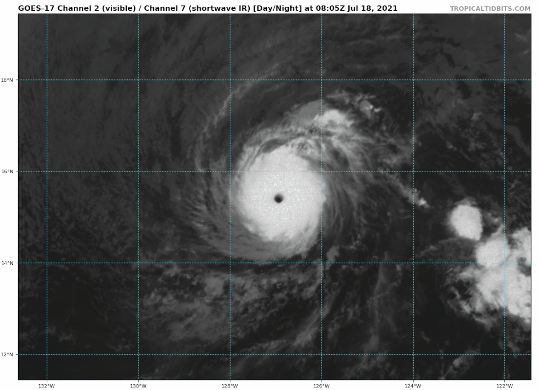
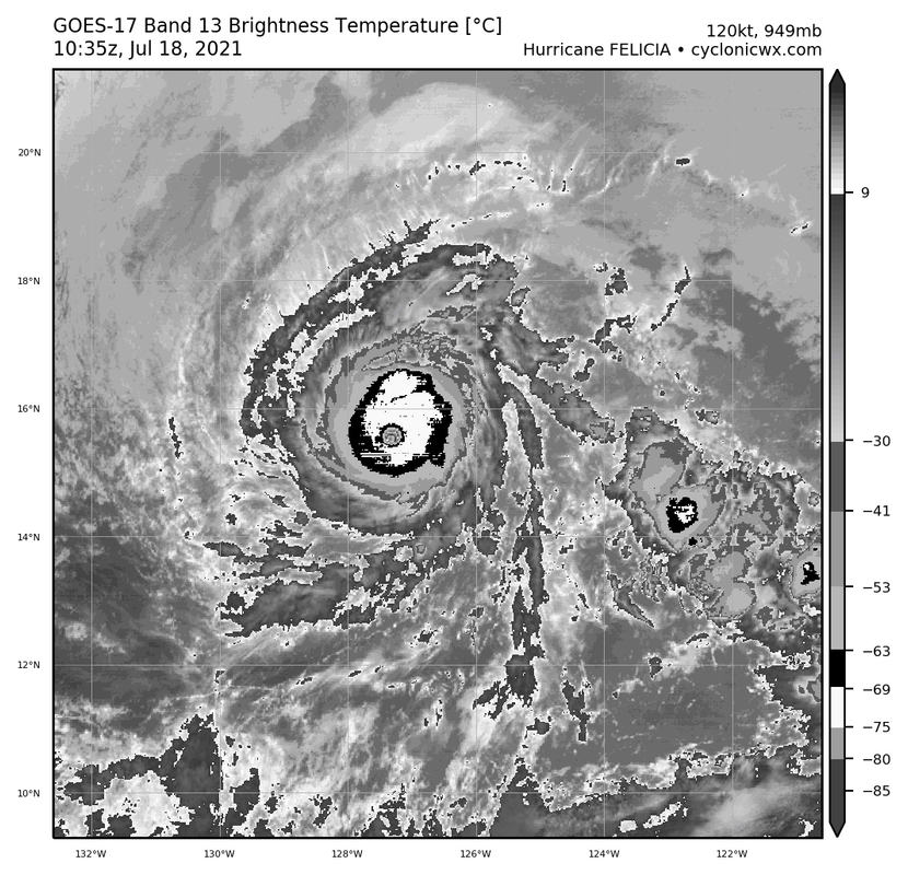
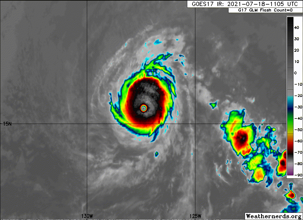
Some changes have been seen with Felicia during the past several
hours. The eye is not quite as warm in satellite pictures, and
there are banding features present in the eastern semicircle of the
hurricane. Overall, Felicia's previously very symmetric appearance
has become a little distorted to the northeast. Both SAB and TAFB
give an initial wind estimate of 115 kt, and that value is used for
this advisory.

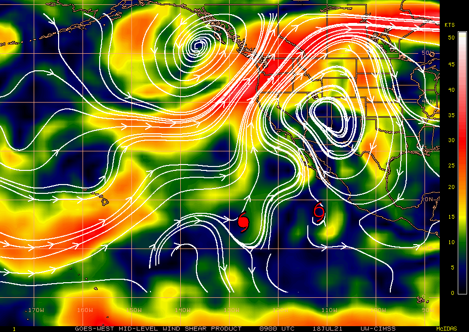
The big question is when will Felicia begin to weaken more
significantly. Any environmental changes are fairly subtle during
the next couple of days, with somewhat cooler waters and a slight
increase in upper-level shear likely. While annular structure
tends to be more stable, Felicia is a very small tropical cyclone,
and those petite systems usually weaken quickly in marginal
environments. Additionally, the latest microwave data has some
suggestion of the early stages of an eyewall cycle (although it
showed the same thing yesterday without much impact). All of these
complex factors lead to this being a low confidence forecast during
the next day or two. The new intensity forecast is a bit lower
than the previous one, owing to the recent degradation in
structure, but is still above the guidance mean. In about 3 days,
much stronger shear should impact Felicia, leading to a quick death
near or just after day 4.

Felicia is moving west-northwestward at about 10 kt. The cyclone is
expected to turn westward by Monday, then move west-southwestward
through midweek as Felicia becomes steered by a large ridge across
the central Pacific. There is a little more spread in the guidance
this morning, partially related to exactly how quickly Felicia
weakens. The ECMWF, for instance, shows a faster decrease in wind
speed, and is more to the southwest of the other guidance,
consistent with the low-level steering flow. The GFS has the system
moving slower and a little more poleward due to its stronger
depiction of Felicia. The new forecast is slightly weighted toward
the GFS solution, near the TCVN consensus, resulting in a small
northward adjustment.


FORECAST POSITIONS AND MAX WINDS

INIT 18/1500Z 15.7N 128.1W 115 KT 130 MPH
12H 19/0000Z 16.1N 129.6W 105 KT 120 MPH
24H 19/1200Z 16.3N 131.7W 95 KT 110 MPH
36H 20/0000Z 16.4N 133.9W 85 KT 100 MPH
48H 20/1200Z 16.2N 136.3W 75 KT 85 MPH
60H 21/0000Z 15.8N 139.0W 60 KT 70 MPH
72H 21/1200Z 15.2N 141.6W 45 KT 50 MPH
96H 22/1200Z 14.2N 146.8W 30 KT 35 MPH
120H 23/1200Z 13.5N 152.5W 25 KT 30 MPH...POST-TROP/REMNT LOW

$$
Forecaster Blake
0 likes   
Visit the Caribbean-Central America Weather Thread where you can find at first post web cams,radars
and observations from Caribbean basin members Click Here


Return to “2021”

Who is online

Users browsing this forum: No registered users and 27 guests