EPAC: GUILLERMO - Post-Tropical

Moderator: S2k Moderators

Message
Author
User avatar
cycloneye
Admin
Admin
Posts: 139090
Age: 67
Joined: Thu Oct 10, 2002 10:54 am
Location: San Juan, Puerto Rico

Re: EPAC: GUILLERMO - Tropical Storm

#61 Postby cycloneye » Sun Jul 18, 2021 11:31 am

Tropical Storm Guillermo Discussion Number 5
NWS National Hurricane Center Miami FL EP072021
900 AM MDT Sun Jul 18 2021

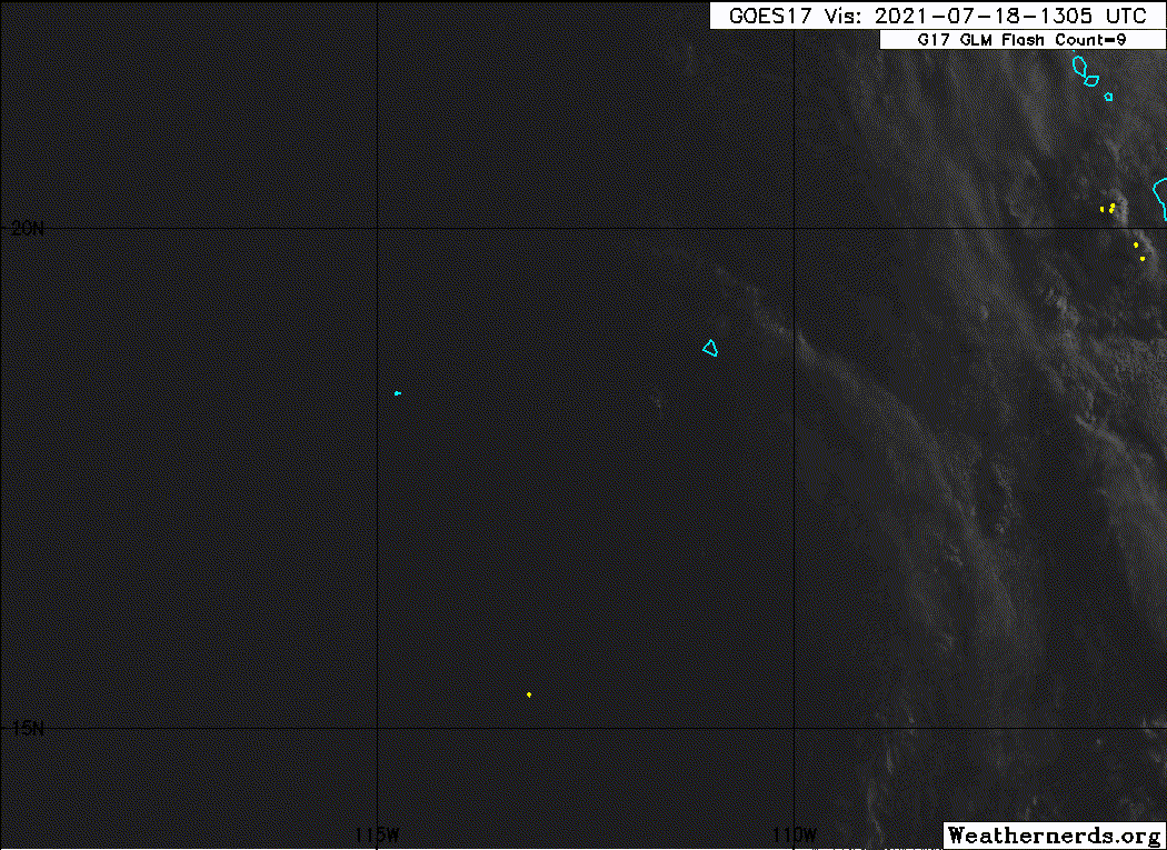
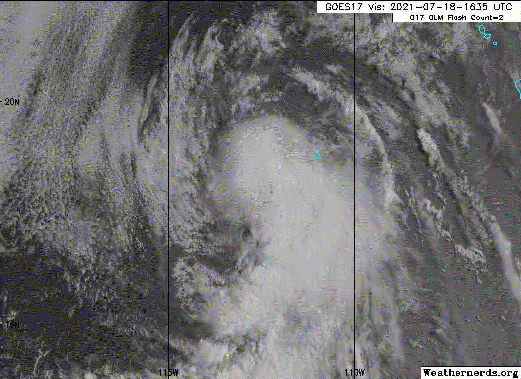
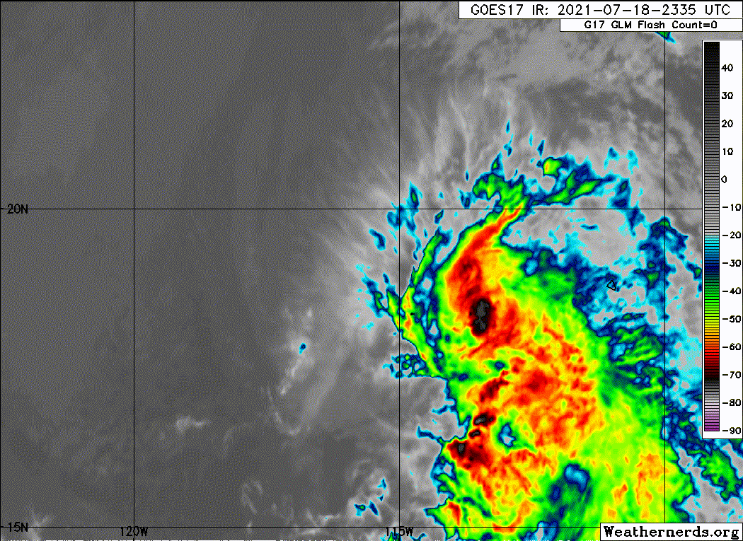
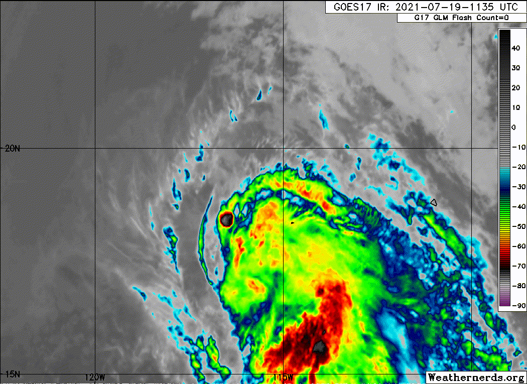
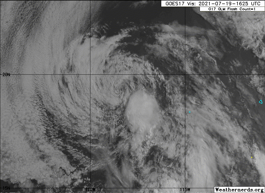
Guillermo's structure has changed little this morning. Very cold
overshooting cloud tops associated with deep convection have been
observed near the center of the tropical storm during the past
couple of hours, however most of the convective activity is still
limited to bands extending to the east and south of the tropical
cyclone. Dvorak intensity estimates from TAFB and SAB continue to
support an intensity estimate of 45 kt. Slight strengthening is
anticipated over the next 24 to 36 hours while Guillermo moves over
fairly warm waters. The rate of strengthening will likely be limited
by moderate northwesterly shear (10-20 kt based on SHIPS
diagnostics) and the relatively large size of the system. After
that, Guillermo will move over progressively cooler waters and into
a drier more stable environment which should cause it to slowly
weaken through the middle of the week. The GFS and HWRF forecast
that Guillermo will maintain tropical characteristics through the
end of the week, and this is reflected in the NHC forecast.
However, it is also possible it will become a remnant low by the
end of the forecast period.

The low-level center of Guillermo is obscured by nearby convection,
but it appears that the tropical storm is still moving
west-northwestward, more or less right on the previous forecast
track. Consequently no changes of note were made to the official
track forecast. A mid-level ridge to the north of Guillermo will
steer the cyclone westward for the next several days, likely with a
slight increase in its forward speed. Around day 4 or 5, Guillermo
is expected to weaken sufficiently so that it will become steered
primarily by low-level flow, and a slight bend toward the
west-southwest is anticipated. Like the previous advisory, the NHC
forecast is very near but just barely slower than the latest
multi-model consensus.


FORECAST POSITIONS AND MAX WINDS

INIT 18/1500Z 17.9N 112.5W 45 KT 50 MPH
12H 19/0000Z 18.3N 114.2W 50 KT 60 MPH
24H 19/1200Z 18.6N 116.8W 55 KT 65 MPH
36H 20/0000Z 18.7N 119.6W 55 KT 65 MPH
48H 20/1200Z 18.7N 122.5W 50 KT 60 MPH
60H 21/0000Z 18.6N 125.5W 40 KT 45 MPH
72H 21/1200Z 18.4N 128.4W 35 KT 40 MPH
96H 22/1200Z 17.9N 133.4W 30 KT 35 MPH
120H 23/1200Z 17.5N 138.5W 30 KT 35 MPH

$$
Forecaster Zelinsky
0 likes   
Visit the Caribbean-Central America Weather Thread where you can find at first post web cams,radars
and observations from Caribbean basin members Click Here

Sciencerocks
Category 5
Category 5
Posts: 7286
Age: 38
Joined: Thu Jul 06, 2017 1:51 am

Re: EPAC: GUILLERMO - Tropical Storm

#62 Postby Sciencerocks » Sun Jul 18, 2021 11:35 am

Image
2 likes   

User avatar
Yellow Evan
Professional-Met
Professional-Met
Posts: 15952
Age: 25
Joined: Fri Jul 15, 2011 12:48 pm
Location: Henderson, Nevada/Honolulu, HI
Contact:

Re: EPAC: GUILLERMO - Tropical Storm

#63 Postby Yellow Evan » Sun Jul 18, 2021 1:53 pm

TXPZ26 KNES 181820
TCSENP

A. 07E (GUILLERMO)

B. 18/1730Z

C. 18.5N

D. 112.9W

E. THREE/GOES-W

F. T3.0/3.0

G. IR/EIR/VIS

H. REMARKS...10/10 BANDING RESULTS IN A DT OF 3.5. MET AND PT=3.0. FT
IS BASED ON MET DUE TO PULSING/IRREG CONVECTION.

I. ADDL POSITIONS

NIL


...KONON
0 likes   

User avatar
cycloneye
Admin
Admin
Posts: 139090
Age: 67
Joined: Thu Oct 10, 2002 10:54 am
Location: San Juan, Puerto Rico

Re: EPAC: GUILLERMO - Tropical Storm

#64 Postby cycloneye » Sun Jul 18, 2021 2:12 pm

EP, 07, 2021071818, , BEST, 0, 184N, 1131W, 50, 999, TS
0 likes   
Visit the Caribbean-Central America Weather Thread where you can find at first post web cams,radars
and observations from Caribbean basin members Click Here

User avatar
Yellow Evan
Professional-Met
Professional-Met
Posts: 15952
Age: 25
Joined: Fri Jul 15, 2011 12:48 pm
Location: Henderson, Nevada/Honolulu, HI
Contact:

Re: EPAC: GUILLERMO - Tropical Storm

#65 Postby Yellow Evan » Sun Jul 18, 2021 2:32 pm

Image

Supports 50.
3 likes   

Sciencerocks
Category 5
Category 5
Posts: 7286
Age: 38
Joined: Thu Jul 06, 2017 1:51 am

Re: EPAC: GUILLERMO - Tropical Storm

#66 Postby Sciencerocks » Sun Jul 18, 2021 3:03 pm

Image
0 likes   

User avatar
cycloneye
Admin
Admin
Posts: 139090
Age: 67
Joined: Thu Oct 10, 2002 10:54 am
Location: San Juan, Puerto Rico

Re: EPAC: GUILLERMO - Tropical Storm

#67 Postby cycloneye » Sun Jul 18, 2021 3:41 pm

Tropical Storm Guillermo Discussion Number 6
NWS National Hurricane Center Miami FL EP072021
300 PM MDT Sun Jul 18 2021

Guillermo's convective pattern has not changed significantly since
early this morning, but an ASCAT overpass just after 1600 UTC
revealed that its wind field has expanded. The maximum winds in the
ASCAT data were a little above 45 kt, so the initial intensity has
been increased to 50 kt accordingly. This is just above the latest
Dvorak estimates from TAFB and SAB.

A slight additional increase in the maximum winds appears likely
during the next day or so, owing to favorable environmental
conditions. However, the highly asymmetric structure of Guillermo
and its relatively broad inner-core will continue to be limiting
factors. In about 24 to 36 h, Guillermo will begin to move over
waters colder than 26 deg C, and this should cause the tropical
storm to gradually weaken. After about 72 h, a drier and more stable
environment will likely also contribute to weakening. Despite those
factors, the GFS and HWRF models continue to indicate that Guillermo
could maintain at least some deep convection through the full 5-day
period. The NHC forecast therefore carries Guillermo as a tropical
cyclone through day 5, but it would not be surprising if it became a
remnant low sooner than that. The official intensity forecast is
slightly higher than the intensity consensus, near the SHIPS and GFS
forecasts.

The aforementioned ASCAT data indicated that Guillermo is centered
slightly north of previous estimates and the estimated initial
motion is slightly faster than the previous advisory, at 290/ 12 kt.
The NHC track forecast has been adjusted northward and faster as a
result, but the overall reasoning remains the same. A mid-level
ridge to the north of Guillermo will likely steer the tropical storm
westward beginning tonight. Guillermo should then continue generally
westward for the next several days. A slight west-southwestward
bend is possible late in the forecast period as the cyclone weakens
and becomes primarily steered by low-level flow. The official track
forecast is heavily based on the multi-model consensus.


FORECAST POSITIONS AND MAX WINDS

INIT 18/2100Z 18.7N 113.8W 50 KT 60 MPH
12H 19/0600Z 19.0N 115.7W 55 KT 65 MPH
24H 19/1800Z 19.1N 118.4W 55 KT 65 MPH
36H 20/0600Z 19.0N 121.3W 55 KT 65 MPH
48H 20/1800Z 19.0N 124.2W 50 KT 60 MPH
60H 21/0600Z 18.9N 127.1W 45 KT 50 MPH
72H 21/1800Z 18.6N 129.8W 40 KT 45 MPH
96H 22/1800Z 18.2N 135.0W 35 KT 40 MPH
120H 23/1800Z 18.0N 140.0W 30 KT 35 MPH

$$
Forecaster Zelinsky
0 likes   
Visit the Caribbean-Central America Weather Thread where you can find at first post web cams,radars
and observations from Caribbean basin members Click Here

User avatar
galaxy401
Category 5
Category 5
Posts: 2299
Age: 28
Joined: Sat Aug 25, 2012 9:04 pm
Location: Casa Grande, Arizona

Re: EPAC: GUILLERMO - Tropical Storm

#68 Postby galaxy401 » Sun Jul 18, 2021 5:47 pm

Looks like the center is about to outrun the convection.
0 likes   
Got my eyes on moving right into Hurricane Alley: Florida.

User avatar
cycloneye
Admin
Admin
Posts: 139090
Age: 67
Joined: Thu Oct 10, 2002 10:54 am
Location: San Juan, Puerto Rico

Re: EPAC: GUILLERMO - Tropical Storm

#69 Postby cycloneye » Sun Jul 18, 2021 7:33 pm

07E GUILLERMO 210719 0000 18.8N 114.9W EPAC 45 1001
0 likes   
Visit the Caribbean-Central America Weather Thread where you can find at first post web cams,radars
and observations from Caribbean basin members Click Here

User avatar
cycloneye
Admin
Admin
Posts: 139090
Age: 67
Joined: Thu Oct 10, 2002 10:54 am
Location: San Juan, Puerto Rico

Re: EPAC: GUILLERMO - Tropical Storm

#70 Postby cycloneye » Sun Jul 18, 2021 9:35 pm

Tropical Storm Guillermo Discussion Number 7
NWS National Hurricane Center Miami FL EP072021
500 PM HST Sun Jul 18 2021

Guillermo's convective pattern has eroded significantly since the
previous advisory due to northwesterly vertical wind shear and
entrainment of drier and cooler air. Earlier ASCAT showed the system
was a solid 50-kt tropical cyclone, thus, only slight weakening is
indicated on this advisory to allow for some spin down of the
vortex. Deep convection will likely return near the center later
tonight during the nocturnal convective maximum period, especially
since the cyclone is still going to be moving over sea-surface
temperatures (SST) near 27 deg C, which should result in some slight
re-strengthening or at least hold a steady intensity for the next 24
h or so. By 36 h and beyond, however, Guillermo will be passing over
sub-25C SSTs and into a stronger northwesterly wind shear
environment, which should induce slow but steady weakening through
the rest of the forecast period, with the cyclone becoming a
post-tropical remnant low by 120 hours. The new NHC intensity
forecast is similar to the previous advisory and closely follows the
NOAA-HCCA and IVCN consensus models.

The initial motion estimate is now westward, or 280/13 kt. Guillermo
made a due west lurch at about 18 kt after the central deep
convection dissipated, which resulted in the vortex becoming a
little more vertically shallow. However, the motion over the past
few hours has been fairly steady at around 13 kt. The latest model
guidance is tightly packed about the previous advisory track, so
no significant changes were required since the global and regional
models maintain the strong subtropical ridge to the north of
Guillermo for the next 120 hours. The official forecast track
closely follows a blend of the TVCE and GFEX simple consensus
models, and the HCCA corrected-consensus model.


FORECAST POSITIONS AND MAX WINDS

INIT 19/0300Z 18.9N 115.6W 45 KT 50 MPH
12H 19/1200Z 19.1N 117.6W 45 KT 50 MPH
24H 20/0000Z 19.2N 120.4W 45 KT 50 MPH
36H 20/1200Z 19.1N 123.2W 40 KT 45 MPH
48H 21/0000Z 19.1N 126.1W 35 KT 40 MPH
60H 21/1200Z 18.9N 128.9W 30 KT 35 MPH
72H 22/0000Z 18.6N 131.6W 30 KT 35 MPH
96H 23/0000Z 18.3N 136.7W 25 KT 30 MPH
120H 24/0000Z 18.3N 141.7W 20 KT 25 MPH...POST-TROP/REMNT LOW

$$
Forecaster Stewart
0 likes   
Visit the Caribbean-Central America Weather Thread where you can find at first post web cams,radars
and observations from Caribbean basin members Click Here

Sciencerocks
Category 5
Category 5
Posts: 7286
Age: 38
Joined: Thu Jul 06, 2017 1:51 am

Re: EPAC: GUILLERMO - Tropical Storm

#71 Postby Sciencerocks » Sun Jul 18, 2021 10:04 pm

Image
0 likes   

User avatar
cycloneye
Admin
Admin
Posts: 139090
Age: 67
Joined: Thu Oct 10, 2002 10:54 am
Location: San Juan, Puerto Rico

Re: EPAC: GUILLERMO - Tropical Storm

#72 Postby cycloneye » Mon Jul 19, 2021 4:35 am

Tropical Storm Guillermo Discussion Number 8
NWS National Hurricane Center Miami FL EP072021
1100 PM HST Sun Jul 18 2021

Guillermo is not a well-organized tropical cyclone. The low-level
center is displaced about 90 n mi to the northwest of the main area
of deep convection due to northwesterly shear. Taking the mean of
Dvorak final T and current intensity numbers from TAFB and SAB
gives 40 kt, and scatterometer data from a few hours ago suggest
that this may be a generous estimate for the advisory intensity.

Using center fixes from geostationary and microwave imagery along
with the scatterometer winds gives a westward initial motion, or
about 270/13 kt. A well-defined mid-level ridge of high pressure
to the north of the cyclone should maintain a generally westward
motion throughout the forecast period. The official forecast track
is nudged slightly south of the previous one, mainly on account of
the short-term motion. This track forecast is very close to the
latest dynamical model consensus, TVCE, which is usually a very
good performer.

Assuming that some deep convection redevelops nearer to the center
over the next day or two, Guillermo may be able to maintain some of
its intensity for a while. Also, the relatively large circulation
should take some time to spin down as shown by the global models.
However, gradually cooling SSTs, dry mid-level air and continued
shear are expected to cause the cyclone to weaken to a depression in
a couple of days and to degenerate into a remnant low by the end of
the forecast period, if not sooner. The official intensity forecast
is similar to the numerical consensus, IVCN.


FORECAST POSITIONS AND MAX WINDS

INIT 19/0900Z 18.8N 116.8W 40 KT 45 MPH
12H 19/1800Z 18.9N 118.9W 40 KT 45 MPH
24H 20/0600Z 18.9N 121.7W 40 KT 45 MPH
36H 20/1800Z 18.7N 124.6W 35 KT 40 MPH
48H 21/0600Z 18.5N 127.5W 35 KT 40 MPH
60H 21/1800Z 18.3N 130.3W 30 KT 35 MPH
72H 22/0600Z 18.2N 132.8W 25 KT 30 MPH
96H 23/0600Z 18.2N 137.8W 25 KT 30 MPH
120H 24/0600Z 18.0N 144.0W 20 KT 25 MPH...POST-TROP/REMNT LOW

$$
Forecaster Pasch
0 likes   
Visit the Caribbean-Central America Weather Thread where you can find at first post web cams,radars
and observations from Caribbean basin members Click Here

Sciencerocks
Category 5
Category 5
Posts: 7286
Age: 38
Joined: Thu Jul 06, 2017 1:51 am

Re: EPAC: GUILLERMO - Tropical Storm

#73 Postby Sciencerocks » Mon Jul 19, 2021 10:04 am

Image
0 likes   

Sciencerocks
Category 5
Category 5
Posts: 7286
Age: 38
Joined: Thu Jul 06, 2017 1:51 am

Re: EPAC: GUILLERMO - Tropical Storm

#74 Postby Sciencerocks » Mon Jul 19, 2021 10:05 am

000
WTPZ42 KNHC 191437
TCDEP2

Tropical Storm Guillermo Discussion Number 9
NWS National Hurricane Center Miami FL EP072021
500 AM HST Mon Jul 19 2021

Guillermo's satellite presentation has continued to deteriorate
over the past several hours, although a new, small deep convective
burst has developed just to the southeast of the circulation
center. An earlier AMSR2 microwave overpass revealed a rather
elongated (west to east) and ill-defined circulation with
fragmented bands in the southeast quadrant. The initial intensity
is lowered to 35 kt and is based on a blend of the TAFB and SAB
Dvorak satellite intensity estimates.

Guillermo is moving over cooler (about 25C) water and into a
progressively more stable and drier surrounding environment.
The statistical-dynamical SHIPS models (GFS/ECMWF) indicate that
moderate west-northwesterly shear should also contribute to the
cyclone's degeneration to a remnant low on Wednesday night. The
intensity forecast now shows Guillermo becoming a remnant low
sooner than the previous advisory and conforms with a consensus of
the large-scale models and the SHIPS forecasts.

The initial motion is estimated to be westward, or 275/13 kt. A
subtropical ridge anchored to the north of the cyclone should
influence a generally westward motion through dissipation at day 5.
A few of the global models are now showing the lower levels
of the ridge building some to the east-northeast of the Hawaiian
Islands which could induce a west-southwestward motion, or slightly
left of due west, around mid-period. The NHC forecast is once
again adjusted a bit to the left of the previous one and is based on
the various consensus aids.


FORECAST POSITIONS AND MAX WINDS

INIT 19/1500Z 19.1N 117.8W 35 KT 40 MPH
12H 20/0000Z 19.0N 119.9W 35 KT 40 MPH
24H 20/1200Z 18.9N 123.0W 30 KT 35 MPH
36H 21/0000Z 18.6N 126.1W 30 KT 35 MPH
48H 21/1200Z 18.3N 128.9W 30 KT 35 MPH
60H 22/0000Z 18.1N 131.4W 25 KT 30 MPH...POST-TROP/REMNT LOW
72H 22/1200Z 17.9N 134.1W 25 KT 30 MPH...POST-TROP/REMNT LOW
96H 23/1200Z 17.9N 139.6W 25 KT 30 MPH...POST-TROP/REMNT LOW
120H 24/1200Z 17.9N 145.6W 25 KT 30 MPH...POST-TROP/REMNT LOW

$$
Forecaster Roberts
0 likes   

User avatar
Yellow Evan
Professional-Met
Professional-Met
Posts: 15952
Age: 25
Joined: Fri Jul 15, 2011 12:48 pm
Location: Henderson, Nevada/Honolulu, HI
Contact:

Re: EPAC: GUILLERMO - Tropical Storm

#75 Postby Yellow Evan » Mon Jul 19, 2021 10:42 am

Pathetic.
0 likes   

User avatar
cycloneye
Admin
Admin
Posts: 139090
Age: 67
Joined: Thu Oct 10, 2002 10:54 am
Location: San Juan, Puerto Rico

Re: EPAC: GUILLERMO - Tropical Storm

#76 Postby cycloneye » Mon Jul 19, 2021 1:47 pm

TD.

07E GUILLERMO 210719 1800 19.3N 119.0W EPAC 30 1007
0 likes   
Visit the Caribbean-Central America Weather Thread where you can find at first post web cams,radars
and observations from Caribbean basin members Click Here

Sciencerocks
Category 5
Category 5
Posts: 7286
Age: 38
Joined: Thu Jul 06, 2017 1:51 am

Re: EPAC: GUILLERMO - Tropical Storm

#77 Postby Sciencerocks » Mon Jul 19, 2021 2:55 pm

Image
0 likes   

User avatar
Kingarabian
S2K Supporter
S2K Supporter
Posts: 15435
Joined: Sat Aug 08, 2009 3:06 am
Location: Honolulu, Hawaii

Re: EPAC: GUILLERMO - Tropical Depression

#78 Postby Kingarabian » Mon Jul 19, 2021 3:07 pm

So bad
0 likes   
RIP Kobe Bryant

User avatar
aspen
Category 5
Category 5
Posts: 8057
Joined: Sat Oct 12, 2019 7:10 pm
Location: Connecticut, USA

Re: EPAC: GUILLERMO - Tropical Depression

#79 Postby aspen » Mon Jul 19, 2021 3:16 pm

I wouldn’t call this a waste of a name, because it was clearly a mid-grade TS and ASCAT confirmed it.

I will call it a pathetic failure of a storm, however. It took so long to consolidate, then the minute after ASCAT supported 50 kt, it just dissolved.

This really is like Erick and Flossie but taken to the extreme.
0 likes   
Irene '11 Sandy '12 Hermine '16 5/15/2018 Derecho Fay '20 Isaias '20 Elsa '21 Henri '21 Ida '21

I am only a meteorology enthusiast who knows a decent amount about tropical cyclones. Look to the professional mets, the NHC, or your local weather office for the best information.

User avatar
cycloneye
Admin
Admin
Posts: 139090
Age: 67
Joined: Thu Oct 10, 2002 10:54 am
Location: San Juan, Puerto Rico

Re: EPAC: GUILLERMO - Tropical Depression

#80 Postby cycloneye » Mon Jul 19, 2021 3:41 pm

Tropical Depression Guillermo Discussion Number 10
NWS National Hurricane Center Miami FL EP072021
200 PM PDT Mon Jul 19 2021

Guillermo is now producing a small shapeless area of convection
about 70 miles to the southeast of the center, but otherwise, the
cyclone consists mainly of a swirl of low clouds. A recent METOP-A
scatterometer pass showed an area 25-30 kt winds well north (about
90 miles) of the center. Based on this data, the initial intensity
is lowered to 30 kt. With the combined negative contributions of
cool sub 25C oceanic temperatures, stiff west-northwesterly shear
and entrainment of high statically stable marine-layer air,
Guillermo should degenerate to a remnant low by Wednesday night, if
not sooner. The large-scale models and the statistical intensity
guidance show the cyclone opening up into a trough of low pressure
by day 4, and the NHC forecast follows suit.

The depression has increased in forward speed to 15 kt, while moving
westward in the fresh tradewind steering flow. A continued westward
motion on the south side of a low- to mid-level subtropical ridge at
about the same aforementioned speed is forecast during the entire
period. The official track forecast is close to the middle of the
model guidance envelope and a little to the left of the previous
advisory.


FORECAST POSITIONS AND MAX WINDS

INIT 19/2100Z 19.3N 119.8W 30 KT 35 MPH
12H 20/0600Z 19.2N 122.3W 30 KT 35 MPH
24H 20/1800Z 18.8N 125.4W 30 KT 35 MPH
36H 21/0600Z 18.4N 128.4W 25 KT 30 MPH...POST-TROP/REMNT LOW
48H 21/1800Z 18.1N 131.4W 25 KT 30 MPH...POST-TROP/REMNT LOW
60H 22/0600Z 17.8N 133.8W 25 KT 30 MPH...POST-TROP/REMNT LOW
72H 22/1800Z 17.6N 136.4W 20 KT 25 MPH...POST-TROP/REMNT LOW
96H 23/1800Z...DISSIPATED

$$
Forecaster Roberts
0 likes   
Visit the Caribbean-Central America Weather Thread where you can find at first post web cams,radars
and observations from Caribbean basin members Click Here


Return to “2021”

Who is online

Users browsing this forum: No registered users and 69 guests