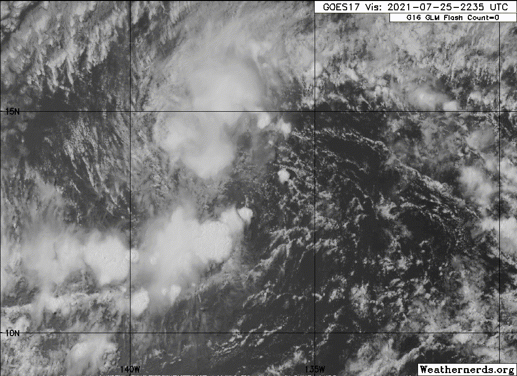
Looks like the convection is out racing the LLC. Might be due to its forward speed. Shear environment over the next 24 hours should be optimal for development so long it can slow down a little bit, to allow convection to persist right over the LLC.
Models seem to want to tighten this up just as it nears 150W, where it will likely be shredded. Shear could be good for the next 48 hours if that's the case.
CPAC: INVEST 90C
Moderator: S2k Moderators
-
Kingarabian

- S2K Supporter

- Posts: 15435
- Joined: Sat Aug 08, 2009 3:06 am
- Location: Honolulu, Hawaii
-
Yellow Evan

- Professional-Met

- Posts: 15952
- Age: 25
- Joined: Fri Jul 15, 2011 12:48 pm
- Location: Henderson, Nevada/Honolulu, HI
- Contact:
Re: EPAC: INVEST 98E
There’s a TUTT cell thereafter that will blast this apart but mid level shear is subsiding as it’s moving away from a mid level anticyclone once this passes 140W.
0 likes
-
Kingarabian
- S2K Supporter
- Posts: 15435
- Joined: Sat Aug 08, 2009 3:06 am
- Location: Honolulu, Hawaii
Re: EPAC: INVEST 98E
Even though its at 70/70, the NHC is saying that this can become a TC at any time:
Tropical Weather Outlook
NWS National Hurricane Center Miami FL
500 PM PDT Sun Jul 25 2021
For the eastern North Pacific...east of 140 degrees west longitude:
1. An area of low pressure located about 1200 miles east-southeast of
the Hawaiian Islands continues to move westward at about 15 mph.
Showers and thunderstorms associated with the system have persisted
for much of the day, but they remain displaced to the northwest and
north of the circulation center. Environmental conditions are
expected to remain conducive for some additional development during
the next day or so, and only a slight increase in the organization
of the system would result in the development of a tropical
depression. The low is forecast to move into the Central Pacific
basin on Monday morning, and on Tuesday conditions are expected to
become unfavorable for further development.
* Formation chance through 48 hours...high...70 percent.
* Formation chance through 5 days...high...70 percent.
0 likes
RIP Kobe Bryant
-
Kingarabian
- S2K Supporter
- Posts: 15435
- Joined: Sat Aug 08, 2009 3:06 am
- Location: Honolulu, Hawaii
Re: EPAC: INVEST 98E
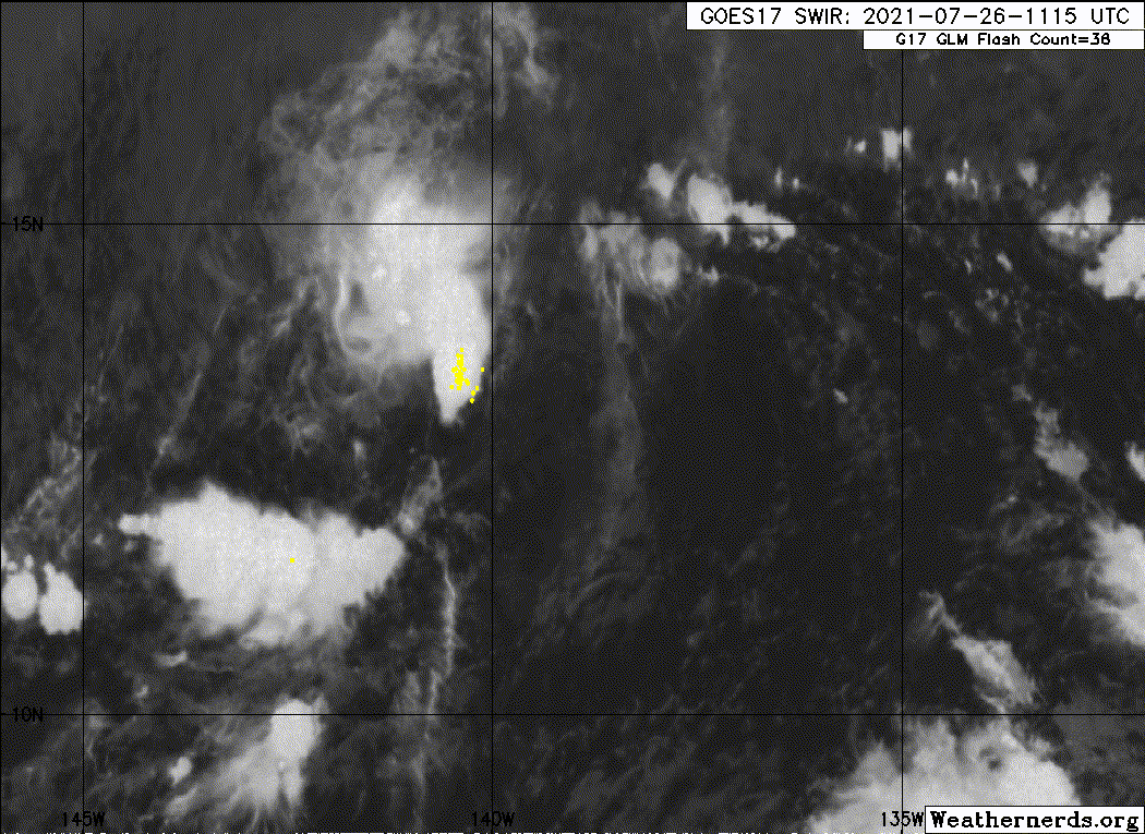
TXPZ27 KNES 252353
TCSENP
A. TROPICAL DISTURBANCE (98E)
B. 25/2330Z
C. 13.1N
D. 137.5W
E. THREE/GOES-W
F. T2.0/2.5
G. IR/EIR/VIS
H. REMARKS...CIRCULARLY DEFINED CLOUD LINES LOCATED LESS THAN 75NM FROM
A SMALL, COLD OVERCAST RESULTS IN A DT OF 1.5 USING THE SHEAR MATRIX. THE
MET IS EQUAL TO 2.0 BASED ON A SLOW DEVELOPMENT TREND OVER THE PAST 24
HOURS. THE PT IS ALSO 2.0. FT IS BASED ON MET DUE TO THE CLOUD FEATURES
NOT BEING CLEAR CUT.
I. ADDL POSITIONS
NIL
...COVERDALE
0 likes
RIP Kobe Bryant
-
Yellow Evan
- Professional-Met
- Posts: 15952
- Age: 25
- Joined: Fri Jul 15, 2011 12:48 pm
- Location: Henderson, Nevada/Honolulu, HI
- Contact:
Re: EPAC: INVEST 98E
Shear seems to have changed back to easterly from southeasterly unless I’m getting my directions mixed up.
0 likes
-
Sciencerocks
- Category 5

- Posts: 7286
- Age: 38
- Joined: Thu Jul 06, 2017 1:51 am
-
ElectricStorm

- Category 5
- Posts: 4562
- Age: 23
- Joined: Tue Aug 13, 2019 11:23 pm
- Location: Skiatook, OK / Norman, OK
Re: EPAC: INVEST 98E
It's now or never for this one
1. A well-defined low pressure system located about 1100 miles
east-southeast of the Hawaiian Islands continues to move westward at
about 15 mph. Shower and thunderstorm activity remains disorganized,
and environmental conditions are gradually becoming less conducive
for additional development to occur. However, any increase in the
organization of the shower activity would result in the formation of
a tropical depression on Monday. The low is forecast to move into
the Central Pacific basin by late Monday morning, and by Tuesday
conditions are expected to become unfavorable for further
development.
* Formation chance through 48 hours...medium...60 percent.
* Formation chance through 5 days...medium...60 percent.
0 likes
I am in no way a professional. Take what I say with a grain of salt as I could be totally wrong. Please refer to the NHC, NWS, or SPC for official information.
Boomer Sooner!
Boomer Sooner!
-
cycloneye

- Admin

- Posts: 139094
- Age: 67
- Joined: Thu Oct 10, 2002 10:54 am
- Location: San Juan, Puerto Rico
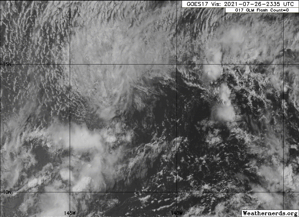
Re: CPAC: INVEST 90C
The invest is now at CPAC so the invest number and basin has changed from 98E to 90C.
CP, 90, 2021072612, , BEST, 0, 129N, 1401W, 25, 1009, LO
0 likes
Visit the Caribbean-Central America Weather Thread where you can find at first post web cams,radars
and observations from Caribbean basin members Click Here
and observations from Caribbean basin members Click Here
-
Sciencerocks
- Category 5
- Posts: 7286
- Age: 38
- Joined: Thu Jul 06, 2017 1:51 am
-
cycloneye
- Admin
- Posts: 139094
- Age: 67
- Joined: Thu Oct 10, 2002 10:54 am
- Location: San Juan, Puerto Rico
Re: CPAC: INVEST 90C
Tropical Weather Outlook
NWS Central Pacific Hurricane Center Honolulu HI
800 AM HST Mon Jul 26 2021
For the central North Pacific...between 140W and 180W:
An elongated area of low pressure located more than 1000
miles east-southeast of Hilo, Hawaii, as it continues to move
westward at about 15 mph. The feature is producing disorganized
showers and thunderstorms. Environmental conditions are gradually
becoming less conducive for development of a tropical depression.
By Tuesday, conditions are expected to become unfavorable for any
further development.
* Formation chance through 48 hours...low...30 percent.
* Formation chance through 5 days...low...30 percent.
Elsewhere, no tropical cyclones are expected during the next 5
days.
$$
Forecaster Almanza
0 likes
Visit the Caribbean-Central America Weather Thread where you can find at first post web cams,radars
and observations from Caribbean basin members Click Here
and observations from Caribbean basin members Click Here
-
cycloneye
- Admin
- Posts: 139094
- Age: 67
- Joined: Thu Oct 10, 2002 10:54 am
- Location: San Juan, Puerto Rico
Re: CPAC: INVEST 90C
Tropical Weather Outlook
NWS Central Pacific Hurricane Center Honolulu HI
200 PM HST Mon Jul 26 2021
For the central North Pacific...between 140W and 180W:
An elongated area of low pressure located about 1000
miles east-southeast of Hilo, Hawaii continues to move
westward near 15 mph. Shower and thunderstorm coverage has
decreased through the day, and environmental conditions are
becoming less conducive for development of a tropical depression.
By Tuesday, conditions are expected to become unfavorable for any
further development.
* Formation chance through 48 hours...low...10 percent.
* Formation chance through 5 days...low...10 percent.
Elsewhere, no tropical cyclones are expected during the next 5
days.
$$
Forecaster Almanza
0 likes
Visit the Caribbean-Central America Weather Thread where you can find at first post web cams,radars
and observations from Caribbean basin members Click Here
and observations from Caribbean basin members Click Here
-
Sciencerocks
- Category 5
- Posts: 7286
- Age: 38
- Joined: Thu Jul 06, 2017 1:51 am
Who is online
Users browsing this forum: No registered users and 14 guests