ATL: INVEST 90L - Discussion

Moderator: S2k Moderators

Message
Author
User avatar
abajan
S2K Supporter
S2K Supporter
Posts: 4175
Joined: Sun Sep 07, 2003 5:10 am
Location: Barbados

Re: ATL: INVEST 90L - Discussion

#181 Postby abajan » Sun Jul 25, 2021 1:01 pm

cycloneye wrote:
Tropical Weather Outlook
NWS National Hurricane Center Miami FL
200 PM EDT Sun Jul 25 2021

For the North Atlantic...Caribbean Sea and the Gulf of Mexico:

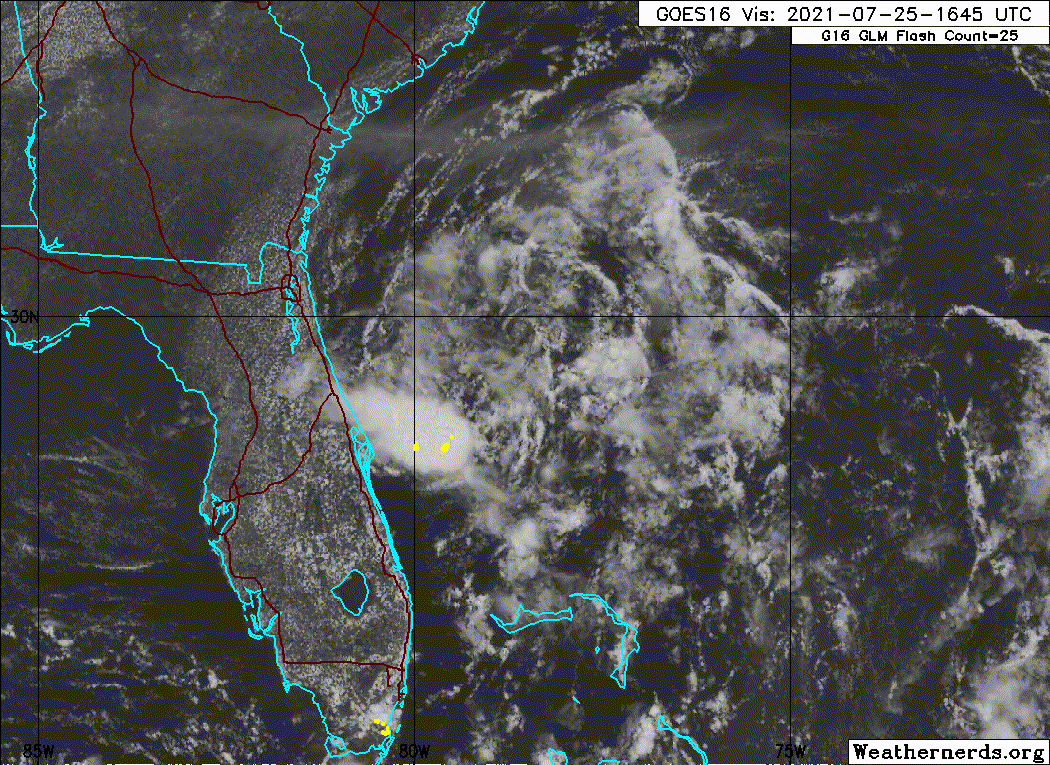
A low pressure area located about 150 miles east of Daytona Beach,
Florida, is producing disorganized shower and thunderstorm activity
mainly over the southern part of its circulation. Preliminary
reports from an Air Force Reserve reconnaissance aircraft indicate
that this system has changed little in strength since yesterday.
Environmental conditions are marginally conducive for development,
and a tropical depression could still form later today or early
Monday while the low drifts westward or west-northwestward toward
the northeast coast of Florida. Interests in Florida should
continue to monitor the progress of this system.
* Formation chance through 48 hours...medium...50 percent.
* Formation chance through 5 days...medium...50 percent.

$$
Forecaster Pasch


Wow, still at 50%!
Interesting.
0 likes   

psyclone
S2K Supporter
S2K Supporter
Posts: 4487
Joined: Wed Aug 24, 2005 9:04 pm
Location: palm harbor fl

Re: ATL: INVEST 90L - Discussion

#182 Postby psyclone » Sun Jul 25, 2021 1:18 pm

Good thing i don't make bets! I would have put my chips on a reduced probability and lost...again!
0 likes   

AlphaToOmega
Category 5
Category 5
Posts: 1448
Joined: Sat Jun 26, 2021 10:51 am
Location: Somewhere in Massachusetts

Re: ATL: INVEST 90L - Discussion

#183 Postby AlphaToOmega » Sun Jul 25, 2021 2:11 pm

The NHC is likely still keeping the 50% chance because of model support. 15 global and hurricane models show Invest 90L developing.
Image
0 likes   

User avatar
Category5Kaiju
Category 5
Category 5
Posts: 3357
Age: 22
Joined: Thu Dec 24, 2020 12:45 pm
Location: Seattle

Re: ATL: INVEST 90L - Discussion

#184 Postby Category5Kaiju » Sun Jul 25, 2021 2:17 pm

AlphaToOmega wrote:The NHC is likely still keeping the 50% chance because of model support. 15 global and hurricane models show Invest 90L developing.
https://i.postimg.cc/bYHHcG6F/90-L-intensity-latest.png


Into a TD? Perhaps, although not many show TS. We’ll have to wait though and see what happens soon, it still has some time over water
0 likes   
Unless explicitly stated, all information covered in my posts is based on my opinions and observations. Please refer to a professional meteorologist or an accredited weather research agency otherwise, especially if serious decisions must be made in the event of a potentially life-threatening tropical storm or hurricane.

User avatar
NDG
S2K Supporter
S2K Supporter
Posts: 14933
Joined: Sun Jul 09, 2006 10:14 pm
Location: Orlando, FL

Re: ATL: INVEST 90L - Discussion

#185 Postby NDG » Sun Jul 25, 2021 2:22 pm

AlphaToOmega wrote:
NDG wrote:
AlphaToOmega wrote:This can still develop if it somehow recurves out to sea. It is too early to make a definitive judgement about the development of this system.


You should at least get an E for effort & persistency for looking for anything that "could" make it develop :wink:


The NHC still has it at a 50% chance for a reason. Plus, the HWRF still shows development. I still need to see what the 12Z ECMWF says in terms of chances. We are also approaching diurnal minimum. The GEFS ensembles and hurricane models are split about whether or not this system will recurve out to sea or go into the Gulf.

This looks like a mesoscale convective vortex. We got Hurricane Barry out of one. I still think it has a chance. :spam:


Are you looking at the same HWRF that I am looking? :lol:
This is not an MCV any more, it clearly is a weak surface low pressure now. It might have been a couple of days ago but since then the convection has died off after tracking to the south.
BTW, the 12z Euro still shows no development.
1 likes   

User avatar
InfernoFlameCat
Category 5
Category 5
Posts: 1966
Age: 21
Joined: Mon Dec 14, 2020 10:52 am
Location: Buford, GA

Re: ATL: INVEST 90L - Discussion

#186 Postby InfernoFlameCat » Sun Jul 25, 2021 2:31 pm

Convergence is helping convection. If this becomes a tc I predict this short convective burst will dwindle and then refire into deep convection. if not it will dwindle into nothingness.
0 likes   
I am by no means a professional. DO NOT look at my forecasts for official information or make decisions based on what I post.

Goal: to become a registered expert over tropical and subtropical cyclones.

xironman
S2K Supporter
S2K Supporter
Posts: 2159
Joined: Sun Jun 10, 2007 4:53 pm
Location: NoVA

Re: ATL: INVEST 90L - Discussion

#187 Postby xironman » Sun Jul 25, 2021 2:48 pm

Nice little llc found by recon, hard to believe there is a 29kt surface wind.
0 likes   

User avatar
Nimbus
Category 5
Category 5
Posts: 4928
Joined: Mon Jul 19, 2004 10:54 am

Re: ATL: INVEST 90L - Discussion

#188 Postby Nimbus » Sun Jul 25, 2021 3:20 pm

There is a tiny surface circulation which we didn't expect to do much with the dry air, didn't even develop a squall line across south Florida that I was expecting.
3 likes   

AlphaToOmega
Category 5
Category 5
Posts: 1448
Joined: Sat Jun 26, 2021 10:51 am
Location: Somewhere in Massachusetts

Re: ATL: INVEST 90L - Discussion

#189 Postby AlphaToOmega » Sun Jul 25, 2021 4:16 pm

The latest ECMWF 12Z run has increased the chance of the development Invest 90L from 10-20% to 30-40%. There is also a subtropical feature that the NHC is not monitoring for some reason.

https://www.ecmwf.int/en/forecasts/charts/catalogue/medium-tc-genesis?facets=Parameters,Tropical%20cyclones&time=2021072512,72,2021072812&projection=classical_global&layer_name=genesis_td
0 likes   

User avatar
wwizard
Tropical Low
Tropical Low
Posts: 48
Joined: Tue Oct 27, 2020 11:28 pm
Location: TEXAS

Re: ATL: INVEST 90L - Discussion

#190 Postby wwizard » Sun Jul 25, 2021 4:17 pm

AlphaToOmega wrote:This is your reminder that storms can form on land

OMG! Stop trying to wish this thing into existance.
8 likes   
Alicia, Allison, Ike, Harvey

Sciencerocks
Category 5
Category 5
Posts: 7286
Age: 38
Joined: Thu Jul 06, 2017 1:51 am

Re: ATL: INVEST 90L - Discussion

#191 Postby Sciencerocks » Sun Jul 25, 2021 4:39 pm

Image
0 likes   

User avatar
Hypercane_Kyle
Category 5
Category 5
Posts: 2899
Joined: Sat Mar 07, 2015 7:58 pm
Location: Cape Canaveral, FL

Re: ATL: INVEST 90L - Discussion

#192 Postby Hypercane_Kyle » Sun Jul 25, 2021 4:56 pm

Ironically, the weather here in Tampa the past two days has been the best since May.
1 likes   
My posts are my own personal opinion, defer to the National Hurricane Center (NHC) and other NOAA products for decision making during hurricane season.

User avatar
toad strangler
S2K Supporter
S2K Supporter
Posts: 4162
Joined: Sun Jul 28, 2013 3:09 pm
Location: Earth
Contact:

Re: ATL: INVEST 90L - Discussion

#193 Postby toad strangler » Sun Jul 25, 2021 4:57 pm

There literally looks like nothing is left of 90L.
2 likes   

User avatar
NDG
S2K Supporter
S2K Supporter
Posts: 14933
Joined: Sun Jul 09, 2006 10:14 pm
Location: Orlando, FL

Re: ATL: INVEST 90L - Discussion

#194 Postby NDG » Sun Jul 25, 2021 4:58 pm

AlphaToOmega wrote:The latest ECMWF 12Z run has increased the chance of the development Invest 90L from 10-20% to 30-40%. There is also a subtropical feature that the NHC is not monitoring for some reason.

https://www.ecmwf.int/en/forecasts/charts/catalogue/medium-tc-genesis?facets=Parameters,Tropical%20cyclones&time=2021072512,72,2021072812&projection=classical_global&layer_name=genesis_td


This is a horrible chart to go by for tropical development, IMO, if you go to the 12z ensembles not one ensemble shows this developing further than the current weak state. The same chart shows high chances for development in the southern Caribbean which we know is not happening. This chart must be showing chances for any little weak surface low to develop like 90L but not that it will become a TD or TS.
7 likes   

User avatar
Jr0d
S2K Supporter
S2K Supporter
Posts: 1174
Joined: Tue Aug 27, 2019 10:52 am
Location: Cayo Hueso

Re: ATL: INVEST 90L - Discussion

#195 Postby Jr0d » Sun Jul 25, 2021 5:47 pm

Still looks horrible.

I was expecting more afternoon thunderstorm across Florida today...but they seemed repressed a bit. Maybe tomorrow when this little swirl is on the coast.

Kind of surprised it's still at 50%....seems to me the chance of development is getting lower by the hour.
2 likes   

AlphaToOmega
Category 5
Category 5
Posts: 1448
Joined: Sat Jun 26, 2021 10:51 am
Location: Somewhere in Massachusetts

Re: ATL: INVEST 90L - Discussion

#196 Postby AlphaToOmega » Sun Jul 25, 2021 5:53 pm

Jr0d wrote:Still looks horrible.

I was expecting more afternoon thunderstorm across Florida today...but they seemed repressed a bit. Maybe tomorrow when this little swirl is on the coast.

Kind of surprised it's still at 50%....seems to me the chance of development is getting lower by the hour.


I believe the NHC is still keeping it at 50% based on model guidance.
0 likes   

User avatar
Category5Kaiju
Category 5
Category 5
Posts: 3357
Age: 22
Joined: Thu Dec 24, 2020 12:45 pm
Location: Seattle

Re: ATL: INVEST 90L - Discussion

#197 Postby Category5Kaiju » Sun Jul 25, 2021 6:20 pm

Oof, now a 40/40 chance of forming..
0 likes   
Unless explicitly stated, all information covered in my posts is based on my opinions and observations. Please refer to a professional meteorologist or an accredited weather research agency otherwise, especially if serious decisions must be made in the event of a potentially life-threatening tropical storm or hurricane.

User avatar
HurricaneBelle
S2K Supporter
S2K Supporter
Posts: 974
Joined: Sun Aug 27, 2006 6:12 pm
Location: Clearwater, FL

Re: ATL: INVEST 90L - Discussion

#198 Postby HurricaneBelle » Sun Jul 25, 2021 6:20 pm

Hypercane_Kyle wrote:Ironically, the weather here in Tampa the past two days has been the best since May.


If you like oppressive heat unbroken by any cloud cover or cooling showers, that is.
0 likes   

AlphaToOmega
Category 5
Category 5
Posts: 1448
Joined: Sat Jun 26, 2021 10:51 am
Location: Somewhere in Massachusetts

Re: ATL: INVEST 90L - Discussion

#199 Postby AlphaToOmega » Sun Jul 25, 2021 6:26 pm

ZCZC MIATWOAT ALL
TTAA00 KNHC DDHHMM

Tropical Weather Outlook
NWS National Hurricane Center Miami FL
800 PM EDT Sun Jul 25 2021

For the North Atlantic...Caribbean Sea and the Gulf of Mexico:

1. Satellite and radar data indicate that showers associated with a low
pressure area located about 150 miles east-southeast of
Jacksonville, Florida, remain disorganized and limited in coverage.
However, environmental conditions are marginally conducive for
development, and a tropical depression could still form overnight or
on Monday while the low moves slowly west-northwestward or
northwestward, reaching the coast of northeastern Florida or Georgia
Monday evening or Monday night. Interests in these areas should
continue to monitor the progress of this system.
* Formation chance through 48 hours...medium...40 percent.
* Formation chance through 5 days...medium...40 percent.

Forecaster Berg
0 likes   

TallyTracker
Category 2
Category 2
Posts: 584
Joined: Thu Oct 11, 2018 2:46 pm

Re: ATL: INVEST 90L - Discussion

#200 Postby TallyTracker » Sun Jul 25, 2021 6:31 pm

This reminds me of STS Andrea in 2007 except weaker. Same area and sparse convection.
0 likes   
Fran '96, Georges '98, Gordon '00, Gabrielle '01, Charley '04, Frances '04, Jeanne '04, Barry '07, Fay '08, Debby '12, Matthew '16, Emily '17, Irma '17, Michael ‘18, Elsa ‘21, Fred ‘21, Mindy ‘21, Nicole ‘22, Idalia ‘23


Return to “2021”

Who is online

Users browsing this forum: No registered users and 76 guests