ATL: INVEST 90L - Discussion
Moderator: S2k Moderators
-
Sciencerocks
- Category 5

- Posts: 7287
- Age: 38
- Joined: Thu Jul 06, 2017 1:51 am
-
AlphaToOmega
- Category 5
- Posts: 1448
- Joined: Sat Jun 26, 2021 10:51 am
- Location: Somewhere in Massachusetts
Re: ATL: INVEST 90L - Discussion
Sciencerocks wrote:https://imagizer.imageshack.com/img923/9885/25u9u6.gif
That should be enough to classify it as a depression.
3 likes
-
Sciencerocks
- Category 5
- Posts: 7287
- Age: 38
- Joined: Thu Jul 06, 2017 1:51 am
Re: ATL: INVEST 90L - Discussion
AlphaToOmega wrote:Sciencerocks wrote:https://imagizer.imageshack.com/img923/9885/25u9u6.gif
That should be enough to classify it as a depression.
If it can sustain this convection until at least 4-5pm est I'd agree.
2 likes


Re: ATL: INVEST 90L - Discussion
West winds over SE FL makes for the best beach conditions from Palm Beach down to Miami, water is a crystal clear pool, no problems with Red Tide or Sargassum. You can't tell 90L is just a few miles to the NE.

0 likes
Re: ATL: INVEST 90L - Discussion
AlphaToOmega wrote:Sciencerocks wrote:https://imagizer.imageshack.com/img923/9885/25u9u6.gif
That should be enough to classify it as a depression.
Look at all of the outflow boundaries on the NE quadrant, convection will not hold too long with so much dry continental air nearby in the mid and upper levels.
I also can't find any winds from nearby ships or buoys higher than 20 knots, 90L is weak.
3 likes
Re: ATL: INVEST 90L - Discussion
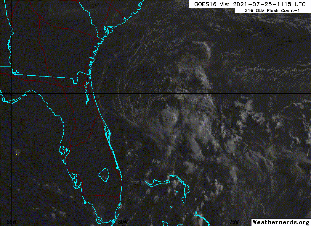
Naked swirls alert, rotating around a broader circulation! 
Also look at now that easterly strong shear taking over, shearing the tops away, that shear goes all the way to the mid levels.

Also look at now that easterly strong shear taking over, shearing the tops away, that shear goes all the way to the mid levels.
5 likes
-
AJC3

- Admin

- Posts: 3873
- Age: 60
- Joined: Tue Aug 31, 2004 7:04 pm
- Location: West Melbourne, Florida
- Contact:
Re: ATL: INVEST 90L - Discussion
A tiny naked swirl has shown itself near 29.7N 78.4W. I doubt it will maintain itself as a trackable feature given how small/exposed it is. And given the dry environment the system is embedded in, all it would take is a small convective blowup nearby to spit out an arcus cloud that would obliterate it. The larger vorticity pouch, which is what you'l want to track, looks more elongated SW-NE (based on the CU lines) than it did yesterday, and the convection remains sporadic/transient. I don't see this getting classified at 5, and, frankly, don't think the chances for this system to become a TD have increased at all.
9 likes
-
AlphaToOmega
- Category 5
- Posts: 1448
- Joined: Sat Jun 26, 2021 10:51 am
- Location: Somewhere in Massachusetts
Re: ATL: INVEST 90L - Discussion
This can still develop if it somehow recurves out to sea. It is too early to make a definitive judgement about the development of this system.
0 likes
-
InfernoFlameCat

- Category 5
- Posts: 1966
- Age: 21
- Joined: Mon Dec 14, 2020 10:52 am
- Location: Buford, GA
Re: ATL: INVEST 90L - Discussion
Looking very unhealthy. never thought this would likely become a td. Usually I am pretty optimistic but this is jus an eyesore.
0 likes
I am by no means a professional. DO NOT look at my forecasts for official information or make decisions based on what I post.
Goal: to become a registered expert over tropical and subtropical cyclones.
Goal: to become a registered expert over tropical and subtropical cyclones.
-
InfernoFlameCat
- Category 5
- Posts: 1966
- Age: 21
- Joined: Mon Dec 14, 2020 10:52 am
- Location: Buford, GA
Re: ATL: INVEST 90L - Discussion
AlphaToOmega wrote:This can still develop if it somehow recurves out to sea. It is too early to make a definitive judgement about the development of this system.
Its not recurving out to sea. Very powerful ridge is driving this west. It might develop in the gulf but I think that is unlikely.
0 likes
I am by no means a professional. DO NOT look at my forecasts for official information or make decisions based on what I post.
Goal: to become a registered expert over tropical and subtropical cyclones.
Goal: to become a registered expert over tropical and subtropical cyclones.
-
Category5Kaiju

- Category 5
- Posts: 3360
- Age: 22
- Joined: Thu Dec 24, 2020 12:45 pm
- Location: Seattle
Re: ATL: INVEST 90L - Discussion
Not sure if it'll recurve on out
0 likes
Unless explicitly stated, all information covered in my posts is based on my opinions and observations. Please refer to a professional meteorologist or an accredited weather research agency otherwise, especially if serious decisions must be made in the event of a potentially life-threatening tropical storm or hurricane.
-
InfernoFlameCat
- Category 5
- Posts: 1966
- Age: 21
- Joined: Mon Dec 14, 2020 10:52 am
- Location: Buford, GA
Re: ATL: INVEST 90L - Discussion
Ok the system is looking a little better with more convection. Still somewhat resembles a MCS
0 likes
I am by no means a professional. DO NOT look at my forecasts for official information or make decisions based on what I post.
Goal: to become a registered expert over tropical and subtropical cyclones.
Goal: to become a registered expert over tropical and subtropical cyclones.
-
wxman57

- Moderator-Pro Met

- Posts: 22482
- Age: 66
- Joined: Sat Jun 21, 2003 8:06 pm
- Location: Houston, TX (southwest)
Re: ATL: INVEST 90L - Discussion
It will be moving inland into NE Florida this evening with no wind and little rain. Too much shear and dry air.
6 likes
-
AlphaToOmega
- Category 5
- Posts: 1448
- Joined: Sat Jun 26, 2021 10:51 am
- Location: Somewhere in Massachusetts
Re: ATL: INVEST 90L - Discussion
AlphaToOmega wrote:This can still develop if it somehow recurves out to sea. It is too early to make a definitive judgement about the development of this system.
You should at least get an E for effort & persistency for looking for anything that "could" make it develop
3 likes
-
Category5Kaiju
- Category 5
- Posts: 3360
- Age: 22
- Joined: Thu Dec 24, 2020 12:45 pm
- Location: Seattle
Re: ATL: INVEST 90L - Discussion
While possible tropical storms forming over land is very rare and something that does not happen every season. I mean sure you could get a Julia 2016, but I would not heavily depend on such
1 likes
Unless explicitly stated, all information covered in my posts is based on my opinions and observations. Please refer to a professional meteorologist or an accredited weather research agency otherwise, especially if serious decisions must be made in the event of a potentially life-threatening tropical storm or hurricane.
-
AlphaToOmega
- Category 5
- Posts: 1448
- Joined: Sat Jun 26, 2021 10:51 am
- Location: Somewhere in Massachusetts
Re: ATL: INVEST 90L - Discussion
NDG wrote:AlphaToOmega wrote:This can still develop if it somehow recurves out to sea. It is too early to make a definitive judgement about the development of this system.
You should at least get an E for effort & persistency for looking for anything that "could" make it develop
The NHC still has it at a 50% chance for a reason. Plus, the HWRF still shows development. I still need to see what the 12Z ECMWF says in terms of chances. We are also approaching diurnal minimum. The GEFS ensembles and hurricane models are split about whether or not this system will recurve out to sea or go into the Gulf.
This looks like a mesoscale convective vortex. We got Hurricane Barry out of one. I still think it has a chance.

0 likes
-
Category5Kaiju
- Category 5
- Posts: 3360
- Age: 22
- Joined: Thu Dec 24, 2020 12:45 pm
- Location: Seattle
Re: ATL: INVEST 90L - Discussion
AlphaToOmega wrote:NDG wrote:AlphaToOmega wrote:This can still develop if it somehow recurves out to sea. It is too early to make a definitive judgement about the development of this system.
You should at least get an E for effort & persistency for looking for anything that "could" make it develop
The NHC still has it at a 50% chance for a reason. Plus, the HWRF still shows development. I still need to see what the 12Z ECMWF says in terms of chances. We are also approaching diurnal minimum. The GEFS ensembles and hurricane models are split about whether or not this system will recurve out to sea or go into the Gulf.
This looks like a mesoscale convective vortex. We got Hurricane Barry out of one. I still think it has a chance.
Haha, yes, Barry 2019 is a great example of how you could have the ugliest system but if it by definition fulfills the hardline characteristics of a TC then it by definition is a TC.
0 likes
Unless explicitly stated, all information covered in my posts is based on my opinions and observations. Please refer to a professional meteorologist or an accredited weather research agency otherwise, especially if serious decisions must be made in the event of a potentially life-threatening tropical storm or hurricane.
Re: ATL: INVEST 90L - Discussion
Whatever chance it has is low and decreasing. I'm surprised the NHC has held development odds at 50% for more than 1 forecast cycle. 50% has been exceedingly charitable.
5 likes
-
cycloneye

- Admin
- Posts: 139135
- Age: 67
- Joined: Thu Oct 10, 2002 10:54 am
- Location: San Juan, Puerto Rico
Re: ATL: INVEST 90L - Discussion
Tropical Weather Outlook
NWS National Hurricane Center Miami FL
200 PM EDT Sun Jul 25 2021
For the North Atlantic...Caribbean Sea and the Gulf of Mexico:
A low pressure area located about 150 miles east of Daytona Beach,
Florida, is producing disorganized shower and thunderstorm activity
mainly over the southern part of its circulation. Preliminary
reports from an Air Force Reserve reconnaissance aircraft indicate
that this system has changed little in strength since yesterday.
Environmental conditions are marginally conducive for development,
and a tropical depression could still form later today or early
Monday while the low drifts westward or west-northwestward toward
the northeast coast of Florida. Interests in Florida should
continue to monitor the progress of this system.
* Formation chance through 48 hours...medium...50 percent.
* Formation chance through 5 days...medium...50 percent.
$$
Forecaster Pasch
0 likes
Visit the Caribbean-Central America Weather Thread where you can find at first post web cams,radars
and observations from Caribbean basin members Click Here
and observations from Caribbean basin members Click Here
Who is online
Users browsing this forum: No registered users and 28 guests