
EPAC: HILDA - Post-Tropical
Moderator: S2k Moderators
-
Sciencerocks
- Category 5

- Posts: 7286
- Age: 38
- Joined: Thu Jul 06, 2017 1:51 am
-
cycloneye

- Admin

- Posts: 139080
- Age: 67
- Joined: Thu Oct 10, 2002 10:54 am
- Location: San Juan, Puerto Rico
Re: EPAC: HILDA - Tropical Storm
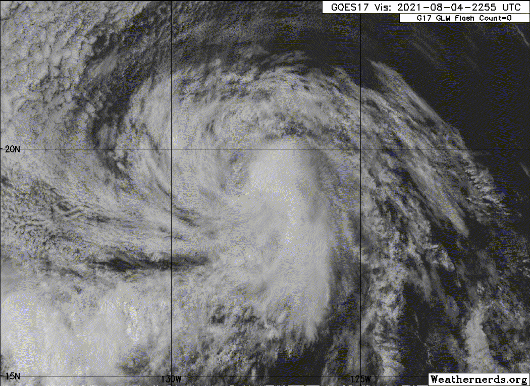
Tropical Storm Hilda Discussion Number 20
NWS National Hurricane Center Miami FL EP082021
800 AM PDT Wed Aug 04 2021
Hilda continues to weaken early this morning due to cool sea-surface
temperatures (SST) and modest northerly vertical wind shear. The
current intensity is estimated to be 35 kt based on an average of
subjective satellite classifications of T2.5/35 kt from both TAFB
and SAB, and objective estimates of 31 kt and 41 kt from UW-CIMSS
ADT and SATCON, respectively. Hilda is currently moving over sub-25C
SSTs with even cooler water and increasing westerly wind shear still
ahead of the cyclone. As a result of these unfavorable environmental
parameters, Hilda is forecast to weaken further, becoming a
depression later today and a remnant low by late tonight or early
Thursday. Dissipation is expected by late Friday or Saturday well
to the east of the Hawaiian Islands. The new NHC official intensity
forecast is similar to the previous advisory, and follows a blend
of the HCCA and IVCN consensus intensity models.
Hilda has been moving west-northwestward or 295/08 kt. This
general motion should continue into Thursday. Low- to mid-level
ridging to the north of Hilda is expected to gradually build
westward over the next several days, forcing the cyclone and its
remnants more westward on Friday and Saturday. The new NHC forecast
track is essentially just an update of the previous advisory, and
lies down the middle of the tightly packed consensus track models.
FORECAST POSITIONS AND MAX WINDS
INIT 04/1500Z 19.1N 127.4W 35 KT 40 MPH
12H 05/0000Z 19.7N 128.7W 30 KT 35 MPH
24H 05/1200Z 20.6N 130.6W 25 KT 30 MPH
36H 06/0000Z 21.5N 132.6W 25 KT 30 MPH...POST-TROP/REMNT LOW
48H 06/1200Z 22.2N 135.0W 20 KT 25 MPH...POST-TROP/REMNT LOW
60H 07/0000Z 22.7N 137.3W 20 KT 25 MPH...POST-TROP/REMNT LOW
72H 07/1200Z...DISSIPATED
$$
Forecaster Stewart
0 likes
Visit the Caribbean-Central America Weather Thread where you can find at first post web cams,radars
and observations from Caribbean basin members Click Here
and observations from Caribbean basin members Click Here
-
Sciencerocks
- Category 5
- Posts: 7286
- Age: 38
- Joined: Thu Jul 06, 2017 1:51 am

-
Sciencerocks
- Category 5
- Posts: 7286
- Age: 38
- Joined: Thu Jul 06, 2017 1:51 am
-
cycloneye
- Admin
- Posts: 139080
- Age: 67
- Joined: Thu Oct 10, 2002 10:54 am
- Location: San Juan, Puerto Rico
Re: EPAC: HILDA - Tropical Storm
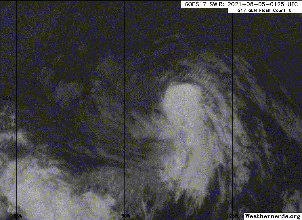
Tropical Storm Hilda Discussion Number 22
NWS National Hurricane Center Miami FL EP082021
800 PM PDT Wed Aug 04 2021
Hilda's satellite appearance has changed little over the past
several hours. Small bursts of moderate to deep convection persist
in the eastern semicircle of the system, and the low-level center is
still partially exposed to the west of the convective cloud mass.
Without any recent scatterometer data, the initial intensity is held
at 35 kt for this advisory, in best agreement with a T2.5/35 kt
Dvorak classification from TAFB.
A subtropical ridge over the eastern North Pacific continues to
steer Hilda west-northwestward, or 290/7 kt. This general motion is
expected to continue for the next day or so, followed by a slight
westward turn on Friday as the shallow cyclone becomes steered by a
low-level ridge to its north. While most of the models show limited
interaction between Hilda and TD Nine-E to its southwest, it is
worth noting that the GFS moves both Nine-E and Hilda much farther
northward than the rest of the guidance. The GFS solution is not
favored at this time, and the latest NHC track forecast remains very
similar to the previous one and lies near the multi-model guidance
consensus.
Hilda is not expected to remain a tropical storm for much longer. As
sea surface temperatures decrease along its track and the cyclone
moves into a drier, more stable environment, it will become
increasingly difficult for Hilda to sustain organized convection
near its center. The latest NHC forecast calls for Hilda to weaken
to a tropical depression on Thursday and degenerate to a 25-kt
remnant low on Friday morning. Then, the global models agree that
the system should open into a trough and dissipate by Saturday
morning well east of the Hawaiian Islands.
FORECAST POSITIONS AND MAX WINDS
INIT 05/0300Z 19.6N 128.7W 35 KT 40 MPH
12H 05/1200Z 20.2N 130.2W 30 KT 35 MPH
24H 06/0000Z 21.3N 132.4W 30 KT 35 MPH
36H 06/1200Z 22.1N 134.6W 25 KT 30 MPH...POST-TROP/REMNT LOW
48H 07/0000Z 22.6N 137.0W 20 KT 25 MPH...POST-TROP/REMNT LOW
60H 07/1200Z...DISSIPATED
$$
Forecaster Reinhart/Pasch
0 likes
Visit the Caribbean-Central America Weather Thread where you can find at first post web cams,radars
and observations from Caribbean basin members Click Here
and observations from Caribbean basin members Click Here
-
Sciencerocks
- Category 5
- Posts: 7286
- Age: 38
- Joined: Thu Jul 06, 2017 1:51 am
-
Yellow Evan

- Professional-Met

- Posts: 15952
- Age: 25
- Joined: Fri Jul 15, 2011 12:48 pm
- Location: Henderson, Nevada/Honolulu, HI
- Contact:
Re: EPAC: HILDA - Tropical Storm
This is a lot farther away from dying than the NHC is making it sound.
4 likes
-
cycloneye
- Admin
- Posts: 139080
- Age: 67
- Joined: Thu Oct 10, 2002 10:54 am
- Location: San Juan, Puerto Rico
Re: EPAC: HILDA - Tropical Storm
Tropical Storm Hilda Discussion Number 23
NWS National Hurricane Center Miami FL EP082021
200 AM PDT Thu Aug 05 2021
Hilda is maintaining a small, but shrinking area of deep
convection, which has rotated from the southeast to northern portion
of the storm's circulation. A 0405 UTC ASCAT-A and 0522 UTC ASCAT-B
pass had peak wind retrievals of 36 and 40 kt respectively, about
40 n mi northeast of Hilda's center. This scatterometer data
suggests that the storm might have been stronger than estimated
yesterday when the convection was more robust. However, given the
warming cloud tops and shrinking area of convection since that time,
the initial advisory intensity was kept at 35 kt, which still agrees
with the most recent subjective Dvorak estimate from TAFB.
Hilda is moving to the west-northwest at 8 kt as the tropical
cyclone remains steered by a large subtropical ridge over the
eastern North Pacific. As the storm becomes more shallow, its
general motion should bend westward and gradually accelerate due to
the influence of a large low-level ridge centered well northward.
The latest track guidance is slightly more poleward early on, and
the NHC track forecast was nudged a bit further north, but remains a
bit south of the HFIP corrected consensus approach (HCCA). As noted
previously, the GFS model forecast remains a northern outlier, with
more interaction between Hilda and recently upgraded Jimena, and its
solution is not favored at this time.
As Hilda continues to move over increasingly cool ocean waters and
into a drier and more stable environment, the remaining deep
convection will likely dissipate at some point later today.
Additional convective bursts thereafter will become increasingly
unlikely. The latest NHC forecast expects Hilda to weaken to a
tropical depression later today and become a remnant low by
tomorrow. This solution is favored by most of the intensity
guidance. The remnant low is then forecast to open up into a trough
by the weekend, well east of the Hawaiian Islands.
FORECAST POSITIONS AND MAX WINDS
INIT 05/0900Z 20.1N 129.2W 35 KT 40 MPH
12H 05/1800Z 20.9N 130.7W 30 KT 35 MPH
24H 06/0600Z 21.9N 132.9W 30 KT 35 MPH
36H 06/1800Z 22.6N 135.1W 25 KT 30 MPH...POST-TROP/REMNT LOW
48H 07/0600Z 23.2N 137.3W 20 KT 25 MPH...POST-TROP/REMNT LOW
60H 07/1800Z...DISSIPATED
$$
Forecaster Papin/Beven
0 likes
Visit the Caribbean-Central America Weather Thread where you can find at first post web cams,radars
and observations from Caribbean basin members Click Here
and observations from Caribbean basin members Click Here
-
Sciencerocks
- Category 5
- Posts: 7286
- Age: 38
- Joined: Thu Jul 06, 2017 1:51 am
-
Iceresistance

- Category 5
- Posts: 8913
- Age: 20
- Joined: Sat Oct 10, 2020 9:45 am
- Location: Tecumseh, OK/Norman, OK
Re: EPAC: HILDA - Tropical Depression
Hilda is now a Tropical Depression.
8:00 AM PDT Thu Aug 5
Location: 21.0°N 130.2°W
Moving: NW at 13 mph
Min pressure: 1006 mb
Max sustained: 35 mph
Location: 21.0°N 130.2°W
Moving: NW at 13 mph
Min pressure: 1006 mb
Max sustained: 35 mph
0 likes
Bill 2015 & Beta 2020
Winter 2020-2021
All observations are in Tecumseh, OK unless otherwise noted.
Winter posts are focused mainly for Oklahoma & Texas.
Take any of my forecasts with a grain of salt, refer to the NWS, SPC, and NHC for official information
Never say Never with weather! Because ANYTHING is possible!
Winter 2020-2021
All observations are in Tecumseh, OK unless otherwise noted.
Winter posts are focused mainly for Oklahoma & Texas.
Take any of my forecasts with a grain of salt, refer to the NWS, SPC, and NHC for official information
Never say Never with weather! Because ANYTHING is possible!
-
Sciencerocks
- Category 5
- Posts: 7286
- Age: 38
- Joined: Thu Jul 06, 2017 1:51 am

-
cycloneye
- Admin
- Posts: 139080
- Age: 67
- Joined: Thu Oct 10, 2002 10:54 am
- Location: San Juan, Puerto Rico
Re: EPAC: HILDA - Tropical Depression
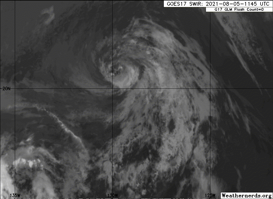
Tropical Depression Hilda Discussion Number 25
NWS National Hurricane Center Miami FL EP082021
200 PM PDT Thu Aug 05 2021
Stubborn Hilda refuses to go away. Convection has been pulsing since
the previous advisory with cloud tops fluctuating between -30C and
-60C in the northeastern quadrant. However, this convection hasn't
mixed higher winds downward into the boundary based on a 1634Z
ASCAT-A scatterometer pass, which showed 30-31-kt wind vectors north
of the center and outside of the convection. The initial intensity
is being maintained at 30 kt for this advisory based on the
aforementioned ASCAT surface wind data. Gradual weakening should
occur now that Hilda is firmly located over sub-23 deg C sea-surface
temperatures and will be moving into a drier and more stable air
mass. Visible satellite imagery already shows an extensive field of
cold-air stratocumulus clouds being entrained into much of the
low-level circulation. Hilda is forecast to degenerate into a
remnant low tonight or early Friday, and open up into a trough by
the weekend, well east of the Hawaiian Islands.
The initial motion estimate is 300/11 kt. Hilda should continue on
a west-northwestward trajectory for the next couple of days, being
steered by a deep-layer subtropical ridge to the north. The latest
NHC track forecast is essentially just an update of the previous
advisory track, and lies down the middle of the tightly packed
consensus models.
FORECAST POSITIONS AND MAX WINDS
INIT 05/2100Z 21.5N 131.2W 30 KT 35 MPH
12H 06/0600Z 22.2N 132.8W 25 KT 30 MPH
24H 06/1800Z 23.0N 135.0W 25 KT 30 MPH...POST-TROP/REMNT LOW
36H 07/0600Z 23.7N 137.2W 20 KT 25 MPH...POST-TROP/REMNT LOW
48H 07/1800Z 24.4N 139.3W 15 KT 15 MPH...POST-TROP/REMNT LOW
60H 08/0600Z...DISSIPATED
$$
Forecaster Stewart
1 likes
Visit the Caribbean-Central America Weather Thread where you can find at first post web cams,radars
and observations from Caribbean basin members Click Here
and observations from Caribbean basin members Click Here
-
captainbarbossa19

- Category 5
- Posts: 1039
- Joined: Wed Aug 21, 2019 11:09 pm
- Location: Starkville, MS
Re: EPAC: HILDA - Tropical Depression
cycloneye wrote:Tropical Depression Hilda Discussion Number 25
NWS National Hurricane Center Miami FL EP082021
200 PM PDT Thu Aug 05 2021
Stubborn Hilda refuses to go away. Convection has been pulsing since
the previous advisory with cloud tops fluctuating between -30C and
-60C in the northeastern quadrant. However, this convection hasn't
mixed higher winds downward into the boundary based on a 1634Z
ASCAT-A scatterometer pass, which showed 30-31-kt wind vectors north
of the center and outside of the convection. The initial intensity
is being maintained at 30 kt for this advisory based on the
aforementioned ASCAT surface wind data. Gradual weakening should
occur now that Hilda is firmly located over sub-23 deg C sea-surface
temperatures and will be moving into a drier and more stable air
mass. Visible satellite imagery already shows an extensive field of
cold-air stratocumulus clouds being entrained into much of the
low-level circulation. Hilda is forecast to degenerate into a
remnant low tonight or early Friday, and open up into a trough by
the weekend, well east of the Hawaiian Islands.
The initial motion estimate is 300/11 kt. Hilda should continue on
a west-northwestward trajectory for the next couple of days, being
steered by a deep-layer subtropical ridge to the north. The latest
NHC track forecast is essentially just an update of the previous
advisory track, and lies down the middle of the tightly packed
consensus models.
FORECAST POSITIONS AND MAX WINDS
INIT 05/2100Z 21.5N 131.2W 30 KT 35 MPH
12H 06/0600Z 22.2N 132.8W 25 KT 30 MPH
24H 06/1800Z 23.0N 135.0W 25 KT 30 MPH...POST-TROP/REMNT LOW
36H 07/0600Z 23.7N 137.2W 20 KT 25 MPH...POST-TROP/REMNT LOW
48H 07/1800Z 24.4N 139.3W 15 KT 15 MPH...POST-TROP/REMNT LOW
60H 08/0600Z...DISSIPATED
$$
Forecaster Stewart
"Stubborn Hilda refuses to go away." Hahahaha!
3 likes
-
cycloneye
- Admin
- Posts: 139080
- Age: 67
- Joined: Thu Oct 10, 2002 10:54 am
- Location: San Juan, Puerto Rico
Re: EPAC: HILDA - Tropical Depression
Tropical Depression Hilda Discussion Number 26
NWS National Hurricane Center Miami FL EP082021
800 PM PDT Thu Aug 05 2021
The low-level center of Hilda has been partially exposed in visible
satellite imagery as the system struggles to sustain any organized
convection. Although a scatterometer pass around 1830 UTC showed
winds near tropical-storm-force in the northeastern quadrant, the
satellite presentation of Hilda has continued to deteriorate during
the past several hours. Therefore, the initial intensity is
maintained at 30 kt for this advisory.
Gradual weakening is expected over the next day or so as Hilda moves
over even cooler waters and into a drier, more stable environment.
These conditions should suppress new convective development, as
suggested by the latest GFS and ECMWF model simulated satellite
imagery. Thus, the latest NHC official forecast shows Hilda
degenerating into a remnant low on Friday. Thereafter, the weakening
remnant low is forecast to open up into a trough on Saturday, well
east of the Hawaiian Islands.
Hilda is moving northwestward or 305/11 kt. The cyclone is expected
to turn more west-northwestward overnight and maintain this heading
through dissipation as it moves along the southern periphery of a
low-level ridge to its north. The track models are still tightly
clustered, and the official NHC forecast has only been adjusted to
reflect the slower forward speed noted in the latest guidance.
FORECAST POSITIONS AND MAX WINDS
INIT 06/0300Z 22.2N 132.2W 30 KT 35 MPH
12H 06/1200Z 22.8N 133.7W 25 KT 30 MPH
24H 07/0000Z 23.5N 135.6W 20 KT 25 MPH...POST-TROP/REMNT LOW
36H 07/1200Z 24.0N 137.3W 20 KT 25 MPH...POST-TROP/REMNT LOW
48H 08/0000Z...DISSIPATED
$$
Forecaster Reinhart/Cangialosi
0 likes
Visit the Caribbean-Central America Weather Thread where you can find at first post web cams,radars
and observations from Caribbean basin members Click Here
and observations from Caribbean basin members Click Here
-
Sciencerocks
- Category 5
- Posts: 7286
- Age: 38
- Joined: Thu Jul 06, 2017 1:51 am

-
cycloneye
- Admin
- Posts: 139080
- Age: 67
- Joined: Thu Oct 10, 2002 10:54 am
- Location: San Juan, Puerto Rico
Re: EPAC: HILDA - Post-Tropical
Post-Tropical Cyclone Hilda Discussion Number 28
NWS National Hurricane Center Miami FL EP082021
800 AM PDT Fri Aug 06 2021
Hilda has been devoid of organized deep convection for at least 12
hours, and since the cyclone is moving over sub-23C sea surface
temperatures, regeneration of deep convection is unlikely.
Therefore, Hilda is designated as a 25 kt post-tropical remnant
low, and this is the last advisory from National Hurricane Center.
The low should continue to move further into a dry and stable air
mass and over even cooler waters. Consequently, weakening is
forecast and the remnant low of Hilda should open up into a trough
of low pressure over the weekend.
The initial motion is estimated to be west-northwestward, or 300/9
kt, and this general heading, within the low-level flow, is
forecast to continue until dissipation.
For additional information on Hilda please see High Seas Forecasts
issued by the National Weather service, under AWIPS header
NFDHSFEPI, WMO header FZPN02 KWBC, and on the web at
ocean.weather.gov/shtml/NFDHSFEPI.php
FORECAST POSITIONS AND MAX WINDS
INIT 06/1500Z 23.1N 134.1W 25 KT 30 MPH...POST-TROPICAL
12H 07/0000Z 23.6N 135.5W 25 KT 30 MPH...POST-TROP/REMNT LOW
24H 07/1200Z 24.1N 137.0W 20 KT 25 MPH...POST-TROP/REMNT LOW
36H 08/0000Z 24.5N 138.2W 20 KT 25 MPH...POST-TROP/REMNT LOW
48H 08/1200Z...DISSIPATED
$$
Forecaster Roberts
0 likes
Visit the Caribbean-Central America Weather Thread where you can find at first post web cams,radars
and observations from Caribbean basin members Click Here
and observations from Caribbean basin members Click Here
Who is online
Users browsing this forum: No registered users and 74 guests