EPAC: IGNACIO - Remnants

Moderator: S2k Moderators

Message
Author
User avatar
cycloneye
Admin
Admin
Posts: 139098
Age: 67
Joined: Thu Oct 10, 2002 10:54 am
Location: San Juan, Puerto Rico

Re: EPAC: INVEST 91E

#21 Postby cycloneye » Sun Aug 01, 2021 12:49 pm

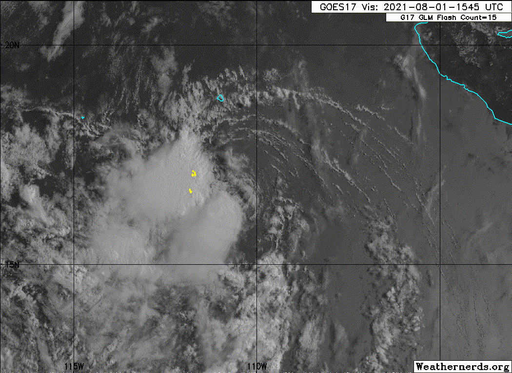
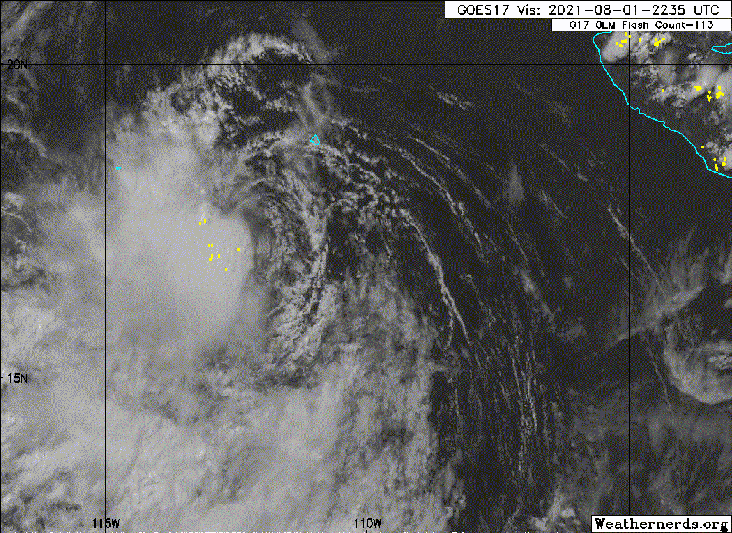
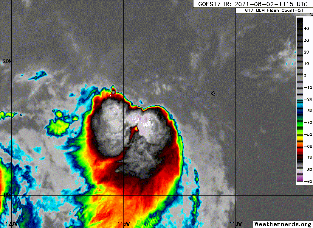
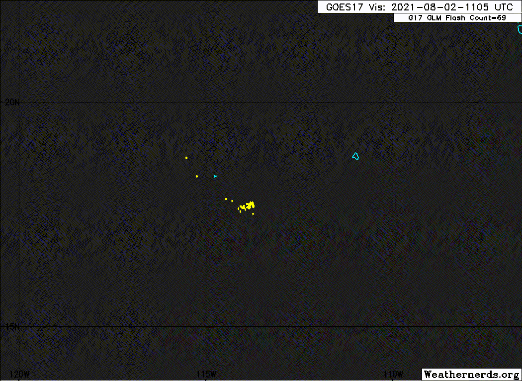
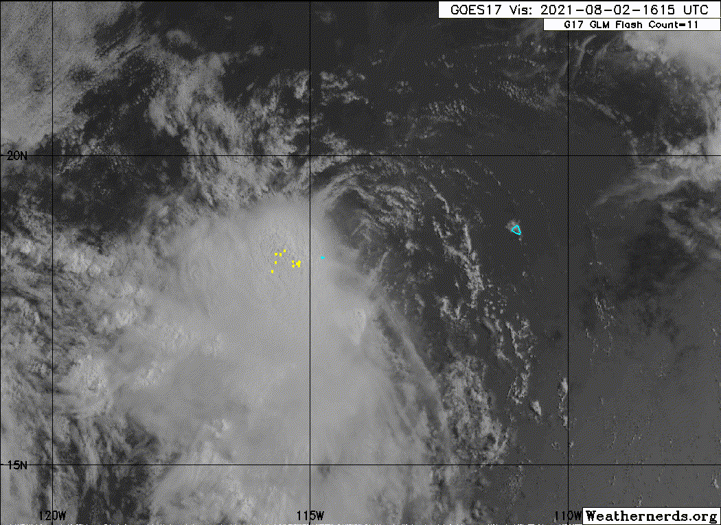
1. A well-defined low pressure system located about 375 miles
west-southwest of Manzanillo, Mexico, is producing a small area of
showers and thunderstorms mainly to the west of the center. The
low is likely to become a tropical depression during the next day or
so while continuing to move west-northwestward at 10 to 15 mph,
away from the coast of Mexico. Development is not likely by late
Monday once the system begins moving over cooler waters.
* Formation chance through 48 hours...high...80 percent.
* Formation chance through 5 days...high...80 percent.
0 likes   
Visit the Caribbean-Central America Weather Thread where you can find at first post web cams,radars
and observations from Caribbean basin members Click Here

Sciencerocks
Category 5
Category 5
Posts: 7286
Age: 38
Joined: Thu Jul 06, 2017 1:51 am

Re: EPAC: INVEST 91E

#22 Postby Sciencerocks » Sun Aug 01, 2021 2:14 pm

Clearly defined LLC with convection sustaining itsself for the past 2 days. I'd expect an upgrade.

Image
2 likes   

User avatar
Yellow Evan
Professional-Met
Professional-Met
Posts: 15952
Age: 25
Joined: Fri Jul 15, 2011 12:48 pm
Location: Henderson, Nevada/Honolulu, HI
Contact:

Re: EPAC: INVEST 91E

#23 Postby Yellow Evan » Sun Aug 01, 2021 2:21 pm

Image

This is a tropical cyclone.
3 likes   

User avatar
Yellow Evan
Professional-Met
Professional-Met
Posts: 15952
Age: 25
Joined: Fri Jul 15, 2011 12:48 pm
Location: Henderson, Nevada/Honolulu, HI
Contact:

Re: EPAC: INVEST 91E

#24 Postby Yellow Evan » Sun Aug 01, 2021 2:23 pm

XPZ21 KNES 011756
TCSENP

A. TROPICAL DISTURBANCE (91E)

B. 01/1730Z

C. 17.0N

D. 111.1W

E. FIVE/GOES-E

F. T2.0/2.0

G. IR/EIR/VIS/SSMIS

H. REMARKS...CIRCULARLY DEFINED CLOUD LINES AND A CENTER LESS THAN 1.25
DEGREES TO THE EAST OF A VERY LARGE COLD OVERCAST RESULTS IN A DT OF
2.0. PT AGREES WHILE MET IS 1.5 BASED ON A SLOW DEVELOPMENT TREND. FT
IS BASED ON PT DUE TO PULSING CONVECTION.

I. ADDL POSITIONS

01/1137Z 16.8N 109.9W SSMIS
01/1336Z 17.1N 110.1W SSMIS


...TURK
0 likes   

User avatar
Yellow Evan
Professional-Met
Professional-Met
Posts: 15952
Age: 25
Joined: Fri Jul 15, 2011 12:48 pm
Location: Henderson, Nevada/Honolulu, HI
Contact:

Re: EPAC: INVEST 91E

#25 Postby Yellow Evan » Sun Aug 01, 2021 2:25 pm

* GFS version *
* EAST PACIFIC 2021 SHIPS INTENSITY FORECAST *
* IR SAT DATA AVAILABLE, OHC AVAILABLE *
* TEN EP102021 08/01/21 18 UTC *

TIME (HR) 0 6 12 18 24 36 48 60 72 84 96 108 120 132 144 156 168
V (KT) NO LAND 30 30 30 30 30 27 26 23 22 21 21 21 21 20 20 19 18
V (KT) LAND 30 30 30 30 30 27 26 23 22 21 21 21 21 20 20 19 18
V (KT) LGEM 30 31 31 31 30 27 23 20 N/A N/A N/A N/A N/A N/A N/A N/A N/A
Storm Type TROP TROP TROP TROP TROP TROP TROP TROP N/A N/A N/A N/A N/A N/A N/A N/A N/A

SHEAR (KT) 19 13 11 10 13 18 23 15 N/A N/A N/A N/A N/A N/A N/A N/A N/A
SHEAR ADJ (KT) 3 4 7 4 3 7 -2 1 N/A N/A N/A N/A N/A N/A N/A N/A N/A
SHEAR DIR 24 24 20 27 37 43 56 73 N/A N/A N/A N/A N/A N/A N/A N/A N/A
SST (C) 28.5 28.0 27.4 27.4 27.5 26.0 25.0 23.6 N/A N/A N/A N/A N/A N/A N/A N/A N/A
POT. INT. (KT) 151 145 139 139 140 124 113 99 N/A N/A N/A N/A N/A N/A N/A N/A N/A
200 MB T (C) -52.7 -52.3 -52.3 -52.6 -52.5 -52.1 -52.3 -52.0 N/A N/A N/A N/A N/A N/A N/A N/A N/A
200 MB VXT (C) 0.3 0.1 0.2 0.1 0.0 0.0 0.0 0.0 N/A N/A N/A N/A N/A N/A N/A N/A N/A
TH_E DEV (C) 6 5 4 4 2 1 0 0 N/A N/A N/A N/A N/A N/A N/A N/A N/A
700-500 MB RH 74 73 73 74 70 68 65 65 N/A N/A N/A N/A N/A N/A N/A N/A N/A
MODEL VTX (KT) 12 12 10 10 10 7 LOST LOST LOST LOST LOST LOST LOST LOST LOST LOST LOST
850 MB ENV VOR 0 9 21 28 31 12 0 -22 N/A N/A N/A N/A N/A N/A N/A N/A N/A
200 MB DIV 2 20 61 74 59 1 24 9 N/A N/A N/A N/A N/A N/A N/A N/A N/A
700-850 TADV -1 -6 -7 -6 -10 -14 -22 -20 N/A N/A N/A N/A N/A N/A N/A N/A N/A
LAND (KM) 661 634 634 668 709 785 897 993 N/A N/A N/A N/A N/A N/A N/A N/A N/A
LAT (DEG N) 17.1 xx.x xx.x xx.x xx.x xx.x xx.x xx.x xx.x xx.x xx.x xx.x xx.x xx.x xx.x xx.x xx.x
LONG(DEG W) 111.4 xxx.x xxx.x xxx.x xxx.x xxx.x xxx.x xxx.x xxx.x xxx.x xxx.x xxx.x xxx.x xxx.x xxx.x xxx.x xxx.x
STM SPEED (KT) 13 12 12 12 12 11 11 11 N/A N/A N/A N/A N/A N/A N/A N/A N/A
HEAT CONTENT 11 7 4 4 5 0 0 0 N/A N/A N/A N/A N/A N/A N/A N/A N/A

FORECAST TRACK FROM OFPI INITIAL HEADING/SPEED (DEG/KT):295/ 14 CX,CY: -12/ 6
T-12 MAX WIND: 25 PRESSURE OF STEERING LEVEL (MB): 553 (MEAN=587)
GOES IR BRIGHTNESS TEMP. STD DEV. 50-200 KM RAD: 27.9 (MEAN=14.5)
% GOES IR PIXELS WITH T < -20 C 50-200 KM RAD: 43.0 (MEAN=65.0)
PRELIM RI PROB (DV .GE. 35 KT IN 36 HR): 0.0

INDIVIDUAL CONTRIBUTIONS TO INTENSITY CHANGE
6 12 18 24 36 48 60 72 84 96 108 120 132 144 156 168
------------------------------------------------------------------------------
SAMPLE MEAN CHANGE 0. 0. 1. 1. 1. 2. 1. 1. 0. -0. -1. -2. -2. -3. -4. -4.
SST POTENTIAL 0. 1. 1. 2. 6. 10. 14. 17. 20. 21. 22. 22. 21. 21. 21. 22.
VERTICAL SHEAR MAG 1. 1. 2. 3. 4. 2. -0. -3. -6. -8. -8. -8. -8. -9. -11. -12.
VERTICAL SHEAR ADJ -0. -1. -1. -1. -3. -2. -2. -1. -1. -0. -0. -0. -0. -0. -1. -1.
VERTICAL SHEAR DIR 0. 0. 0. 0. -0. -1. -2. -2. -3. -3. -3. -3. -3. -3. -2. -2.
PERSISTENCE 1. 1. 1. 1. 1. 1. 1. 1. 1. 1. 1. 1. 1. 1. 1. 1.
200/250 MB TEMP. -0. -0. -0. -0. -1. -1. -1. -2. -2. -3. -3. -3. -4. -4. -4. -5.
THETA_E EXCESS -0. -0. -1. -1. -3. -5. -7. -8. -8. -9. -10. -10. -10. -11. -12. -14.
700-500 MB RH 0. 0. 0. 0. 1. 1. 1. 1. 1. 1. 1. 1. 1. 2. 3. 4.
MODEL VTX TENDENCY 0. -1. -1. -1. -3. -4. -5. -6. -6. -6. -6. -5. -5. -4. -4. -4.
850 MB ENV VORTICITY -0. -0. -0. -0. -0. 0. 0. 0. 0. 1. 1. 1. 1. 1. 1. 1.
200 MB DIVERGENCE -0. -0. -0. 0. -0. -0. -1. -1. -1. -1. -1. -1. -1. -0. 0. 0.
850-700 T ADVEC 0. 0. 0. 0. 0. -0. -0. -0. -0. -1. -1. -1. -2. -3. -3. -5.
ZONAL STORM MOTION 0. 0. 1. 1. 1. 2. 2. 2. 2. 1. 1. 1. 1. 1. 0. -0.
STEERING LEVEL PRES -0. -0. -0. -0. -0. -0. -0. -0. -0. -0. -0. -1. -0. -0. -0. -0.
DAYS FROM CLIM. PEAK 0. 0. 0. 0. 0. 0. 0. 0. 0. 0. 0. 0. 0. 0. 0. 1.
GOES PREDICTORS -1. -1. -2. -2. -2. -3. -4. -4. -5. -5. -6. -6. -6. -6. -4. -4.
OCEAN HEAT CONTENT -0. -0. -0. -0. -0. -1. -1. -1. -0. -0. 0. 1. 2. 2. 4. 5.
RI POTENTIAL -0. -1. -2. -3. -4. -5. -3. -1. 1. 2. 4. 4. 5. 5. 4. 4.
------------------------------------------------------------------------------
TOTAL CHANGE 0. -0. -0. 0. -3. -4. -7. -8. -9. -9. -9. -9. -10. -10. -11. -12.

CURRENT MAX WIND (KT): 30. LAT, LON: 17.1 111.4

** 2021 E. Pacific RI INDEX EP102021 TEN 08/01/21 18 UTC **
(SHIPS-RII PREDICTOR TABLE for 30 KT OR MORE MAXIMUM WIND INCREASE IN NEXT 24-h)

Predictor Value RI Predictor Range Scaled Value(0-1) % Contribution
POT = MPI-VMAX (KT) : 112.6 40.5 to 149.3 0.66 4.1
12 HR PERSISTENCE (KT) : 5.0 -22.0 to 44.0 0.41 2.9
D200 (10**7s-1) : 43.2 -33.0 to 159.5 0.40 2.3
850-200 MB SHEAR (KT) : 13.3 19.6 to 1.3 0.35 1.9
MAXIMUM WIND (KT) : 30.0 22.5 to 132.0 0.21 0.9
STD DEV OF IR BR TEMP : 27.9 37.8 to 2.1 0.28 1.1
BL DRY-AIR FLUX (W/M2) : 107.4 800.8 to -82.5 0.79 -3.4
HEAT CONTENT (KJ/CM2) : 6.2 2.7 to 106.7 0.03 0.1
%area of TPW <45 mm upshear : 0.0 56.6 to 0.0 1.00 1.2
2nd PC OF IR BR TEMP : -1.9 2.2 to -2.3 0.92 0.6

SHIPS Prob RI for 20kt/ 12hr RI threshold= 3% is 0.6 times climatological mean ( 6.3%)
SHIPS Prob RI for 25kt/ 24hr RI threshold= 12% is 1.0 times climatological mean (12.5%)
SHIPS Prob RI for 30kt/ 24hr RI threshold= 12% is 1.4 times climatological mean ( 8.6%)
SHIPS Prob RI for 35kt/ 24hr RI threshold= 11% is 1.7 times climatological mean ( 6.2%)
SHIPS Prob RI for 40kt/ 24hr RI threshold= 0% is 0.0 times climatological mean ( 4.2%)
SHIPS Prob RI for 45kt/ 36hr RI threshold= 10% is 1.5 times climatological mean ( 6.7%)
SHIPS Prob RI for 55kt/ 48hr RI threshold= 0% is 0.0 times climatological mean ( 5.9%)
SHIPS Prob RI for 65kt/ 72hr RI threshold= 0% is 0.0 times climatological mean ( 4.7%)

Matrix of RI probabilities
------------------------------------------------------------------------------
RI (kt / h) | 20/12 | 25/24 | 30/24 | 35/24 | 40/24 | 45/36 | 55/48 |65/72
------------------------------------------------------------------------------
SHIPS-RII: 3.5% 11.9% 11.7% 10.8% 0.0% 10.2% 0.0% 0.0%
Logistic: 0.1% 0.4% 0.1% 0.0% 0.0% 0.0% 0.0% 0.0%
Bayesian: 0.0% 0.0% 0.0% 0.0% 0.0% 0.0% 0.0% 0.0%
Consensus: 1.2% 4.1% 3.9% 3.6% 0.0% 3.4% 0.0% 0.0%
DTOPS: 0.0% 1.0% 0.0% 0.0% 0.0% 0.0% 0.0% 0.0%

## ANNULAR HURRICANE INDEX (AHI) EP102021 TEN 08/01/21 18 UTC ##
## STORM NOT ANNULAR, SCREENING STEP FAILED, NPASS=6 NFAIL=1 ##
## AHI= 0 (AHI OF 100 IS BEST FIT TO ANN. STRUC., 1 IS MARGINAL, 0 IS NOT ANNULAR) ##
0 likes   

AlphaToOmega
Category 5
Category 5
Posts: 1448
Joined: Sat Jun 26, 2021 10:51 am
Location: Somewhere in Massachusetts

Re: EPAC: TEN-E - POTENTIAL TROPICAL CYCLONE

#26 Postby AlphaToOmega » Sun Aug 01, 2021 2:36 pm

Now a potential tropical cyclone
EP, 10, 2021080118, , BEST, 0, 171N, 1114W, 30, 1007, DB, 34, NEQ, 0, 0, 0, 0, 1011, 150, 50, 0, 0, E, 0, , 0, 0, TEN, M, 0, , 0, 0, 0, 0, genesis-num, 014, TRANSITIONED, epC12021 to ep102021,

https://ftp.nhc.noaa.gov/atcf/btk/

Potential Tropical Cyclone TEN
As of 18:00 UTC Aug 01, 2021:

Location: 17.1°N 111.4°W
Maximum Winds: 30 kt Gusts: N/A
Minimum Central Pressure: 1007 mb
Environmental Pressure: N/A
Radius of Circulation: N/A
Radius of Maximum wind: 50 nm

https://www.tropicaltidbits.com/storminfo/#10E
0 likes   

User avatar
cycloneye
Admin
Admin
Posts: 139098
Age: 67
Joined: Thu Oct 10, 2002 10:54 am
Location: San Juan, Puerto Rico

Re: EPAC: TEN-E - Tropical Depression

#27 Postby cycloneye » Sun Aug 01, 2021 3:40 pm

Tropical Depression Ten-E Discussion Number 1
NWS National Hurricane Center Miami FL EP102021
300 PM MDT Sun Aug 01 2021

The well-defined low pressure system located well offshore the
southwestern coast of Mexico that the National Hurricane Center has
been monitoring the past few days has developed enough organized
deep convection to be designated as a tropical depression. Although
the convection is strongly sheared and displaced to the west of the
slightly elongated low-level center, barely meeting the criteria for
a tropical cyclone, a recent 1733Z ASCAT-B scatterometer pass
revealed a few 28-kt surface wind vectors in the northeastern
quadrant. Thus, the initial intensity is set at what could be a
generous 30 kt. Socorro Island reported a wind gust to 34 kt in a
passing narrow band of showers around 1630 UTC.

The initial motion estimate is west-northwestward or 300/12 kt.
Embedded within deep-layer east-southeasterly steering flow between
Hurricane Hilda to the west-southwest and a sprawling subtropical
ridge to the north, the cyclone is forecast to continue moving
west-northwestward throughout the relatively short forecast period.
The NHC forecast track lies down the middle of the tightly packed
simple- and corrected-consensus models.

The depression has a very narrow window of opportunity of about 24 h
to strengthen. Moderate-to-strong northeasterly vertical wind shear
that has been hindering development the past few days is expected to
gradually decrease from the current 19-22 kt down to around 10-12 kt
in 18-24 h, which could allow for some slight intensification late
tonight and/or early Monday morning when another nocturnal burst of
convection is likely to occur. By 36 h, however, the cyclone is
forecast to move over sub-26C sea-surface temperatures and into a
drier and more stable air mass, which could induce rapid weakening,
with the system degenerating into a remnant low by 48 h and
dissipation expected by 72 h. The official intensity forecast is
similar to but slightly above the simple- and corrected-consensus
intensity models IVCN and HCCA, respectively.


FORECAST POSITIONS AND MAX WINDS

INIT 01/2100Z 17.4N 111.9W 30 KT 35 MPH
12H 02/0600Z 18.1N 113.5W 30 KT 35 MPH
24H 02/1800Z 19.0N 115.7W 35 KT 40 MPH
36H 03/0600Z 19.9N 117.5W 30 KT 35 MPH
48H 03/1800Z 20.6N 119.3W 25 KT 30 MPH...POST-TROP/REMNT LOW
60H 04/0600Z 20.9N 120.9W 20 KT 25 MPH...POST-TROP/REMNT LOW
72H 04/1800Z...DISSIPATED

$$
Forecaster Stewart
0 likes   
Visit the Caribbean-Central America Weather Thread where you can find at first post web cams,radars
and observations from Caribbean basin members Click Here

User avatar
Yellow Evan
Professional-Met
Professional-Met
Posts: 15952
Age: 25
Joined: Fri Jul 15, 2011 12:48 pm
Location: Henderson, Nevada/Honolulu, HI
Contact:

Re: EPAC: TEN-E - Tropical Depression

#28 Postby Yellow Evan » Sun Aug 01, 2021 7:10 pm

TXPZ21 KNES 012353
TCSENP

A. 10E (NONAME)

B. 01/2330Z

C. 17.3N

D. 112.2W

E. FIVE/GOES-W

F. T2.0/2.0

G. IR/EIR/VIS

H. REMARKS...SYSTEM HAS CIRCULAR DEFINED CLOUD LINES AROUND AN LLCC THAT
IS NEAR THE LARGE ACTIVE COLD OVERCAST RESULTING IN A SHEAR PATTERN DT
OF 2.0. THE 24 HR DEVELOPMENT TREND IS DEVELOPING SLOWLY RESULTING MET
AND PT TO BE 2.0. FT IS BASED ON DT.

I. ADDL POSITIONS

NIL


...PATEL
0 likes   

Sciencerocks
Category 5
Category 5
Posts: 7286
Age: 38
Joined: Thu Jul 06, 2017 1:51 am

Re: EPAC: TEN-E - Tropical Depression

#29 Postby Sciencerocks » Sun Aug 01, 2021 9:01 pm

Image
0 likes   

User avatar
cycloneye
Admin
Admin
Posts: 139098
Age: 67
Joined: Thu Oct 10, 2002 10:54 am
Location: San Juan, Puerto Rico

Re: EPAC: TEN-E - Tropical Depression

#30 Postby cycloneye » Sun Aug 01, 2021 9:38 pm

Tropical Depression Ten-E Discussion Number 2
NWS National Hurricane Center Miami FL EP102021
900 PM MDT Sun Aug 01 2021

The center of the tropical cyclone is located near the northeastern
edge of the main area of deep convection, as the system is
experiencing northeasterly shear due to the flow on the south side
of a large upper-level anticyclone. Enhanced infrared imagery shows
that the convection is very deep over the western part of the
circulation, but there is little evidence of banding features. The
current intensity is held at 30 kt in agreement with a Dvorak
estimate from SAB. Hopefully we will soon obtain some additional
scatterometer data to provide an intensity estimate.

The depression continues its west-northwestward track with a motion
near 295/11 kt. This heading should continue for the next day or
two while the cyclone moves along the southwestern side of a
mid-level high pressure area. In 2-3 days, the track could become
complicated by the interaction with the circulation of Hilda to the
southwest, but the system will probably be quite weak by that time.
The official forecast is close to the previous one but somewhat
slower in the latter part of the period.

Assuming that the low-level center will become at least a little
more embedded within the convection later tonight, the system is
forecast to strengthen into a tropical storm overnight. The storm
will probably be short-lived, however, with increased shear and
cooler waters causing the system to degenerate into a remnant low in
a couple of days. The official forecast is not far from the model
consensus predictions, but a more rapid weakening is predicted by
the global models.


FORECAST POSITIONS AND MAX WINDS

INIT 02/0300Z 17.6N 112.9W 30 KT 35 MPH
12H 02/1200Z 18.3N 114.4W 35 KT 40 MPH
24H 03/0000Z 19.2N 116.2W 35 KT 40 MPH
36H 03/1200Z 20.0N 117.5W 30 KT 35 MPH
48H 04/0000Z 20.4N 118.3W 25 KT 30 MPH...POST-TROP/REMNT LOW
60H 04/1200Z 20.7N 119.0W 20 KT 25 MPH...POST-TROP/REMNT LOW
72H 05/0000Z...DISSIPATED

$$
Forecaster Pasch
0 likes   
Visit the Caribbean-Central America Weather Thread where you can find at first post web cams,radars
and observations from Caribbean basin members Click Here

User avatar
cycloneye
Admin
Admin
Posts: 139098
Age: 67
Joined: Thu Oct 10, 2002 10:54 am
Location: San Juan, Puerto Rico

Re: EPAC: TEN-E - Tropical Depression

#31 Postby cycloneye » Mon Aug 02, 2021 4:30 am

Tropical Depression Ten-E Discussion Number 3
NWS National Hurricane Center Miami FL EP102021
300 AM MDT Mon Aug 02 2021

The depression has not become any better organized overnight. In
fact, the earlier cluster of deep convection that was located to
the west of the center has weakened with the center becoming
farther exposed to the northeast of a new burst of convection that
has recently developed. Unfortunately the tropical cyclone was
located within the gap of the polar-orbiting ASCAT instrument
overnight so there were no scatterometer data to help ascertain the
depression's intensity. Subjective Dvorak estimates from SAB and
TAFB ranged from 30 to 35 kt, and since there has been no overall
change in organization, the intensity is held at 30 kt for this
advisory.

The depression has a short window of opportunity today in which to
become a tropical storm, however increasing shear and cool waters
along the forecast track should end that possibility by early
tonight. Weakening is expected to begin shortly thereafter
as the system moves into aforementioned hostile environmental
conditions, and the cyclone is predicted to become a remnant low by
late Tuesday, and dissipate on Wednesday. The NHC intensity
forecast is close to the intensity consensus and follows the global
model guidance in calling for dissipation in 48-60 h.

The depression is moving west-northwestward or 295/9 kt. The track
forecast reasoning remains unchanged as the cyclone should move
west-northwestward along the southwestern portion of a mid-level
ridge. As the system weakens, it is likely to slow down and turn
westward within the low-level flow around Hilda located to its
southwest. The NHC track prediction remains near the middle of
the guidance envelope, and little modification to the previous
advisory was needed.

FORECAST POSITIONS AND MAX WINDS

INIT 02/0900Z 18.0N 113.4W 30 KT 35 MPH
12H 02/1800Z 18.7N 114.9W 35 KT 40 MPH
24H 03/0600Z 19.6N 116.5W 30 KT 35 MPH
36H 03/1800Z 20.3N 117.7W 25 KT 30 MPH...POST-TROP/REMNT LOW
48H 04/0600Z 20.5N 118.3W 20 KT 25 MPH...POST-TROP/REMNT LOW
60H 04/1800Z...DISSIPATED

$$
Forecaster Brown
0 likes   
Visit the Caribbean-Central America Weather Thread where you can find at first post web cams,radars
and observations from Caribbean basin members Click Here

User avatar
aspen
Category 5
Category 5
Posts: 8057
Joined: Sat Oct 12, 2019 7:10 pm
Location: Connecticut, USA

Re: EPAC: TEN-E - Tropical Depression

#32 Postby aspen » Mon Aug 02, 2021 8:25 am

Now up to 35kt/1005mb TS Ignacio in the 12z best track.
2 likes   
Irene '11 Sandy '12 Hermine '16 5/15/2018 Derecho Fay '20 Isaias '20 Elsa '21 Henri '21 Ida '21

I am only a meteorology enthusiast who knows a decent amount about tropical cyclones. Look to the professional mets, the NHC, or your local weather office for the best information.

User avatar
Yellow Evan
Professional-Met
Professional-Met
Posts: 15952
Age: 25
Joined: Fri Jul 15, 2011 12:48 pm
Location: Henderson, Nevada/Honolulu, HI
Contact:

Re: EPAC: TEN-E - Tropical Depression

#33 Postby Yellow Evan » Mon Aug 02, 2021 8:50 am

TXPZ21 KNES 021204
TCSENP

A. 10E (NONAME)

B. 02/1130Z

C. 18.1N

D. 113.7W

E. THREE/GOES-W

F. T2.5/2.5

G. IR/EIR/SWIR/GMI

H. REMARKS...CENTER IS LOCATED ON THE NORTHERN EDGE OF A VERY LARGE
COLD OVERCAST RESULTING IN A DT OF 3.0 USING THE SHEAR PATTERN. MET IS
2.5 BASED ON A SLOW DEVELOPMENT TREND. PT AGREES. FT IS BASED ON MET
BECAUSE CONVECTION HAS LACKED PERSISTENCE.

I. ADDL POSITIONS

02/1105Z 18.1N 113.6W GMI


...TURK
0 likes   

User avatar
Yellow Evan
Professional-Met
Professional-Met
Posts: 15952
Age: 25
Joined: Fri Jul 15, 2011 12:48 pm
Location: Henderson, Nevada/Honolulu, HI
Contact:

Re: EPAC: TEN-E - Tropical Depression

#34 Postby Yellow Evan » Mon Aug 02, 2021 9:09 am

* GFS version *
* EAST PACIFIC 2021 SHIPS INTENSITY FORECAST *
* IR SAT DATA AVAILABLE, OHC AVAILABLE *
* TEN EP102021 08/02/21 12 UTC *

TIME (HR) 0 6 12 18 24 36 48 60 72 84 96 108 120 132 144 156 168
V (KT) NO LAND 35 35 34 32 30 25 18 N/A N/A N/A N/A N/A N/A N/A N/A N/A N/A
V (KT) LAND 35 35 34 32 30 25 18 N/A N/A N/A N/A N/A N/A N/A N/A N/A N/A
V (KT) LGEM 35 36 36 35 32 27 22 N/A N/A N/A N/A N/A N/A N/A N/A N/A N/A
Storm Type TROP TROP TROP TROP TROP TROP TROP N/A N/A N/A N/A N/A N/A N/A N/A N/A N/A

SHEAR (KT) 18 15 14 25 28 27 22 N/A N/A N/A N/A N/A N/A N/A N/A N/A N/A
SHEAR ADJ (KT) -1 4 8 8 1 3 8 N/A N/A N/A N/A N/A N/A N/A N/A N/A N/A
SHEAR DIR 41 43 33 42 55 77 93 N/A N/A N/A N/A N/A N/A N/A N/A N/A N/A
SST (C) 27.7 27.7 27.8 27.5 26.6 25.7 25.7 N/A N/A N/A N/A N/A N/A N/A N/A N/A N/A
POT. INT. (KT) 141 141 142 138 128 117 116 N/A N/A N/A N/A N/A N/A N/A N/A N/A N/A
200 MB T (C) -52.9 -52.7 -52.3 -52.3 -52.6 -52.4 -52.6 N/A N/A N/A N/A N/A N/A N/A N/A N/A N/A
200 MB VXT (C) 0.2 0.2 0.1 0.1 0.2 0.2 0.3 N/A N/A N/A N/A N/A N/A N/A N/A N/A N/A
TH_E DEV (C) 4 4 4 3 2 2 2 N/A N/A N/A N/A N/A N/A N/A N/A N/A N/A
700-500 MB RH 72 69 67 68 69 64 64 N/A N/A N/A N/A N/A N/A N/A N/A N/A N/A
MODEL VTX (KT) 11 11 10 8 7 5 2 LOST LOST LOST LOST LOST LOST LOST LOST LOST LOST
850 MB ENV VOR 2 5 6 3 3 -13 -15 N/A N/A N/A N/A N/A N/A N/A N/A N/A N/A
200 MB DIV 43 56 17 16 4 -27 -18 N/A N/A N/A N/A N/A N/A N/A N/A N/A N/A
700-850 TADV -8 -9 -5 -14 -11 -13 -8 N/A N/A N/A N/A N/A N/A N/A N/A N/A N/A
LAND (KM) 652 669 700 714 723 746 770 N/A N/A N/A N/A N/A N/A N/A N/A N/A N/A
LAT (DEG N) 18.1 18.6 19.0 19.4 19.8 20.3 20.4 N/A N/A N/A N/A N/A N/A N/A N/A N/A N/A
LONG(DEG W) 113.6 114.5 115.3 116.1 116.8 117.7 118.1 N/A N/A N/A N/A N/A N/A N/A N/A N/A N/A
STM SPEED (KT) 9 9 9 8 7 3 2 N/A N/A N/A N/A N/A N/A N/A N/A N/A N/A
HEAT CONTENT 6 5 5 5 1 0 0 N/A N/A N/A N/A N/A N/A N/A N/A N/A N/A

FORECAST TRACK FROM OFCI INITIAL HEADING/SPEED (DEG/KT):295/ 8 CX,CY: -6/ 3
T-12 MAX WIND: 30 PRESSURE OF STEERING LEVEL (MB): 632 (MEAN=587)
GOES IR BRIGHTNESS TEMP. STD DEV. 50-200 KM RAD: 32.9 (MEAN=14.5)
% GOES IR PIXELS WITH T < -20 C 50-200 KM RAD: 46.0 (MEAN=65.0)
PRELIM RI PROB (DV .GE. 35 KT IN 36 HR): 0.1

INDIVIDUAL CONTRIBUTIONS TO INTENSITY CHANGE
6 12 18 24 36 48 60 72 84 96 108 120 132 144 156 168
------------------------------------------------------------------------------
SAMPLE MEAN CHANGE 0. 0. 1. 1. 1. 2. 1. 1. 0. -0. -1. -2. -2. -3. -4. -4.
SST POTENTIAL 0. 1. 2. 3. 5. 8. 12. 15. 17. 18. 19. 18. 18. 17. 17. 18.
VERTICAL SHEAR MAG 0. 1. 1. 2. 1. -2. -6. -11. -15. -19. -20. -20. -21. -22. -24. -26.
VERTICAL SHEAR ADJ -0. -1. -1. -1. -2. -3. -3. -2. -1. -1. -0. -0. -0. -0. -1. -1.
VERTICAL SHEAR DIR 0. 0. -0. -0. -1. -1. -1. -2. -2. -2. -2. -2. -2. -2. -2. -2.
PERSISTENCE 1. 1. 1. 1. 1. 1. 1. 1. 1. 1. 1. 1. 1. 1. 1. 1.
200/250 MB TEMP. -0. -0. -0. -0. -0. -1. -1. -1. -1. -1. -2. -2. -2. -2. -2. -2.
THETA_E EXCESS -0. -1. -1. -2. -3. -5. -6. -7. -7. -8. -8. -9. -9. -9. -10. -12.
700-500 MB RH 0. 0. 0. 0. 0. 0. 0. 0. 1. 1. 1. 1. 1. 1. 2. 3.
MODEL VTX TENDENCY 0. -1. -2. -3. -5. -8. -11. -12. -13. -12. -12. -11. -10. -9. -8. -7.
850 MB ENV VORTICITY -0. -0. -0. -0. -0. 0. 0. 1. 1. 1. 1. 1. 1. 1. 1. 1.
200 MB DIVERGENCE 0. -0. -0. -0. -1. -1. -2. -3. -3. -3. -3. -2. -2. -1. 0. 1.
850-700 T ADVEC 0. 0. 0. 0. 0. -0. -0. -0. -0. -0. -1. -1. -2. -2. -3. -4.
ZONAL STORM MOTION 0. 0. 0. -0. -0. -0. -0. -0. -0. -0. -0. -0. -0. -0. -0. 0.
STEERING LEVEL PRES 0. 0. 0. 0. 1. 1. 1. 1. 1. 1. 1. 1. 1. 1. 1. 0.
DAYS FROM CLIM. PEAK 0. 0. 0. 0. 0. 0. 0. 0. 0. 0. 0. 0. 1. 1. 1. 1.
GOES PREDICTORS -1. -2. -3. -3. -3. -3. -4. -4. -4. -4. -5. -5. -5. -4. -3. -2.
OCEAN HEAT CONTENT -0. -0. -0. -0. -0. -1. -1. -1. -0. -0. 0. 1. 2. 2. 4. 5.
RI POTENTIAL -0. -1. -2. -3. -4. -4. -3. -1. 1. 2. 4. 4. 4. 4. 4. 4.
------------------------------------------------------------------------------
TOTAL CHANGE 0. -1. -3. -5. -10. -17. -22. -25. -26. -27. -27. -27. -26. -25. -26. -25.

CURRENT MAX WIND (KT): 35. LAT, LON: 18.1 113.6

** 2021 E. Pacific RI INDEX EP102021 TEN 08/02/21 12 UTC **
(SHIPS-RII PREDICTOR TABLE for 30 KT OR MORE MAXIMUM WIND INCREASE IN NEXT 24-h)

Predictor Value RI Predictor Range Scaled Value(0-1) % Contribution
POT = MPI-VMAX (KT) : 103.0 40.5 to 149.3 0.57 999.0
12 HR PERSISTENCE (KT) : 5.0 -22.0 to 44.0 0.41 999.0
D200 (10**7s-1) : 27.2 -33.0 to 159.5 0.31 999.0
850-200 MB SHEAR (KT) : 19.8 19.6 to 1.3 0.00 0.0
MAXIMUM WIND (KT) : 35.0 22.5 to 132.0 0.36 999.0
STD DEV OF IR BR TEMP : 32.9 37.8 to 2.1 0.14 999.0
BL DRY-AIR FLUX (W/M2) : 154.8 800.8 to -82.5 0.73 999.0
HEAT CONTENT (KJ/CM2) : 4.4 2.7 to 106.7 0.02 999.0
%area of TPW <45 mm upshear : 0.0 56.6 to 0.0 1.00 999.0
2nd PC OF IR BR TEMP : -2.0 2.2 to -2.3 0.94 999.0

SHIPS Prob RI for 20kt/ 12hr RI threshold= 3% is 0.4 times climatological mean ( 6.3%)
SHIPS Prob RI for 25kt/ 24hr RI threshold= 4% is 0.4 times climatological mean (12.5%)
SHIPS Prob RI for 30kt/ 24hr RI threshold= 0% is 0.0 times climatological mean ( 8.6%)
SHIPS Prob RI for 35kt/ 24hr RI threshold= 0% is 0.0 times climatological mean ( 6.2%)
SHIPS Prob RI for 40kt/ 24hr RI threshold= 0% is 0.0 times climatological mean ( 4.2%)
SHIPS Prob RI for 45kt/ 36hr RI threshold= 0% is 0.0 times climatological mean ( 6.7%)
SHIPS Prob RI for 55kt/ 48hr RI threshold= 0% is 0.0 times climatological mean ( 5.9%)
SHIPS Prob RI for 65kt/ 72hr RI threshold= 0% is 0.0 times climatological mean ( 4.7%)

Matrix of RI probabilities
------------------------------------------------------------------------------
RI (kt / h) | 20/12 | 25/24 | 30/24 | 35/24 | 40/24 | 45/36 | 55/48 |65/72
------------------------------------------------------------------------------
SHIPS-RII: 2.8% 4.5% 0.0% 0.0% 0.0% 0.0% 0.0% 0.0%
Logistic: 0.2% 0.1% 0.1% 0.0% 0.0% 0.0% 0.0% 0.0%
Bayesian: 0.0% 0.0% 0.0% 0.0% 0.0% 0.0% 0.0% 0.0%
Consensus: 1.0% 1.5% 0.0% 0.0% 0.0% 0.0% 0.0% 0.0%
DTOPS: 0.0% 0.0% 0.0% 0.0% 0.0% 0.0% 0.0% 0.0%

## ANNULAR HURRICANE INDEX (AHI) EP102021 TEN 08/02/21 12 UTC ##
## STORM NOT ANNULAR, SCREENING STEP FAILED, NPASS=4 NFAIL=3 ##
## AHI= 0 (AHI OF 100 IS BEST FIT TO ANN. STRUC., 1 IS MARGINAL, 0 IS NOT ANNULAR) ##
0 likes   

Sciencerocks
Category 5
Category 5
Posts: 7286
Age: 38
Joined: Thu Jul 06, 2017 1:51 am

Re: EPAC: TEN-E - Tropical Depression

#35 Postby Sciencerocks » Mon Aug 02, 2021 9:36 am

ImageImage
0 likes   

User avatar
cycloneye
Admin
Admin
Posts: 139098
Age: 67
Joined: Thu Oct 10, 2002 10:54 am
Location: San Juan, Puerto Rico

Re: EPAC: IGNACIO - Tropical Storm

#36 Postby cycloneye » Mon Aug 02, 2021 9:38 am

Tropical Storm Ignacio Discussion Number 4
NWS National Hurricane Center Miami FL EP102021
900 AM MDT Mon Aug 02 2021

A large burst of deep convection has developed near the center and
over most of the southwestern semicircle of the cyclone. Recent
subjective satellite intensity estimates are a consensus T2.5/35 kt
from TAFB and SAB, and objective estimates from UW-CIMSS ADT and
SATCON are 37 kt and 39 kt, respectively. Based on these data, the
intensity has been increased to 35 kt, making the system the ninth
tropical storm of the 2021 eastern North Pacific hurricane season.

Tropical Storm Ignacio has continued to move west-northwestward, and
the initial motion estimate is 295/08 kt. Both the track forecast
and synoptic reasoning remain unchanged for this advisory. Ignacio
is expected to maintain a west-northwestward motion, wedged between
a strong mid-/upper-level ridge to the north and Hurricane Hilda to
the southwest throughout the 48-hour forecast period. The new track
forecast is essentially just an update of the previous advisory
track, and lies down the middle of the tightly packed consensus
track models.

Ignacio is likely near its peak intensity given that northeasterly
vertical wind shear of 18-20 kt is expected to keep the strongest
convection displaced away from the strongest surface winds that are
likely occurring in the northeastern semicircle. By 24 hours or so,
Ignacio will be moving over sub-26C sea-surface temperatures and
into even stronger wind shear, which should induce steady weakening,
with dissipation expected by 60 hours. The new NHC intensity
forecast is similar to the previous advisory, and closely follows a
blend of the NOAA-HCCA and IVCN consensus intensity models.


FORECAST POSITIONS AND MAX WINDS

INIT 02/1500Z 18.3N 114.0W 35 KT 40 MPH
12H 03/0000Z 19.0N 115.3W 35 KT 40 MPH
24H 03/1200Z 19.8N 116.7W 30 KT 35 MPH
36H 04/0000Z 20.3N 117.6W 25 KT 30 MPH...POST-TROP/REMNT LOW
48H 04/1200Z 20.7N 118.5W 20 KT 25 MPH...POST-TROP/REMNT LOW
60H 05/0000Z...DISSIPATED

$$
Forecaster Stewart
0 likes   
Visit the Caribbean-Central America Weather Thread where you can find at first post web cams,radars
and observations from Caribbean basin members Click Here

User avatar
Yellow Evan
Professional-Met
Professional-Met
Posts: 15952
Age: 25
Joined: Fri Jul 15, 2011 12:48 pm
Location: Henderson, Nevada/Honolulu, HI
Contact:

Re: EPAC: IGNACIO - Tropical Storm

#37 Postby Yellow Evan » Mon Aug 02, 2021 2:04 pm

TXPZ21 KNES 021805
TCSENP

A. 10E (IGNACIO)

B. 02/1730Z

C. 18.7N

D. 114.5W

E. FIVE/GOES-E

F. T2.0/2.5

G. IR/EIR/VIS

H. REMARKS...CIRCULATION IS LESS ORGANIZED THAN 6 HOURS AGO. CIRCULARLY
DEFINED CLOUD LINES AND A CENTER LESS THAN 1.25 DEGREES FROM A VERY
LARGE COLD OVERCAST RESULTS IN A DT OF 2.0. PT AGREES WHILE MET IS 2.5
BASED ON A SLOW DEVELOPMENT TREND. FT IS BASED ON PT DUE TO UNCERTAINTY
IN THE PRECISE CENTER LOCATION.

I. ADDL POSITIONS

NIL


...TURK
0 likes   

User avatar
wxman57
Moderator-Pro Met
Moderator-Pro Met
Posts: 22482
Age: 66
Joined: Sat Jun 21, 2003 8:06 pm
Location: Houston, TX (southwest)

Re: EPAC: IGNACIO - Tropical Storm

#38 Postby wxman57 » Mon Aug 02, 2021 2:21 pm

Wind shear is tearing it apart now. Won't be around long.
0 likes   

User avatar
Yellow Evan
Professional-Met
Professional-Met
Posts: 15952
Age: 25
Joined: Fri Jul 15, 2011 12:48 pm
Location: Henderson, Nevada/Honolulu, HI
Contact:

Re: EPAC: IGNACIO - Tropical Storm

#39 Postby Yellow Evan » Mon Aug 02, 2021 2:35 pm

EP, 10, 2021080218, , BEST, 0, 186N, 1146W, 35, 1004, TS, 34, NEQ, 40, 0, 0, 0, 1011, 120, 40, 0, 0, E, 0, , 0, 0, IGNACIO, M, 0, , 0, 0, 0, 0, genesis-num, 014,
0 likes   

Sciencerocks
Category 5
Category 5
Posts: 7286
Age: 38
Joined: Thu Jul 06, 2017 1:51 am

Re: EPAC: IGNACIO - Tropical Storm

#40 Postby Sciencerocks » Mon Aug 02, 2021 2:45 pm

Image
2 likes   


Return to “2021”

Who is online

Users browsing this forum: No registered users and 16 guests