EPAC: IGNACIO - Remnants

Moderator: S2k Moderators

Message
Author
User avatar
cycloneye
Admin
Admin
Posts: 139089
Age: 67
Joined: Thu Oct 10, 2002 10:54 am
Location: San Juan, Puerto Rico

Re: EPAC: IGNACIO - Tropical Storm

#41 Postby cycloneye » Mon Aug 02, 2021 3:38 pm

Tropical Storm Ignacio Discussion Number 5
NWS National Hurricane Center Miami FL EP102021
300 PM MDT Mon Aug 02 2021

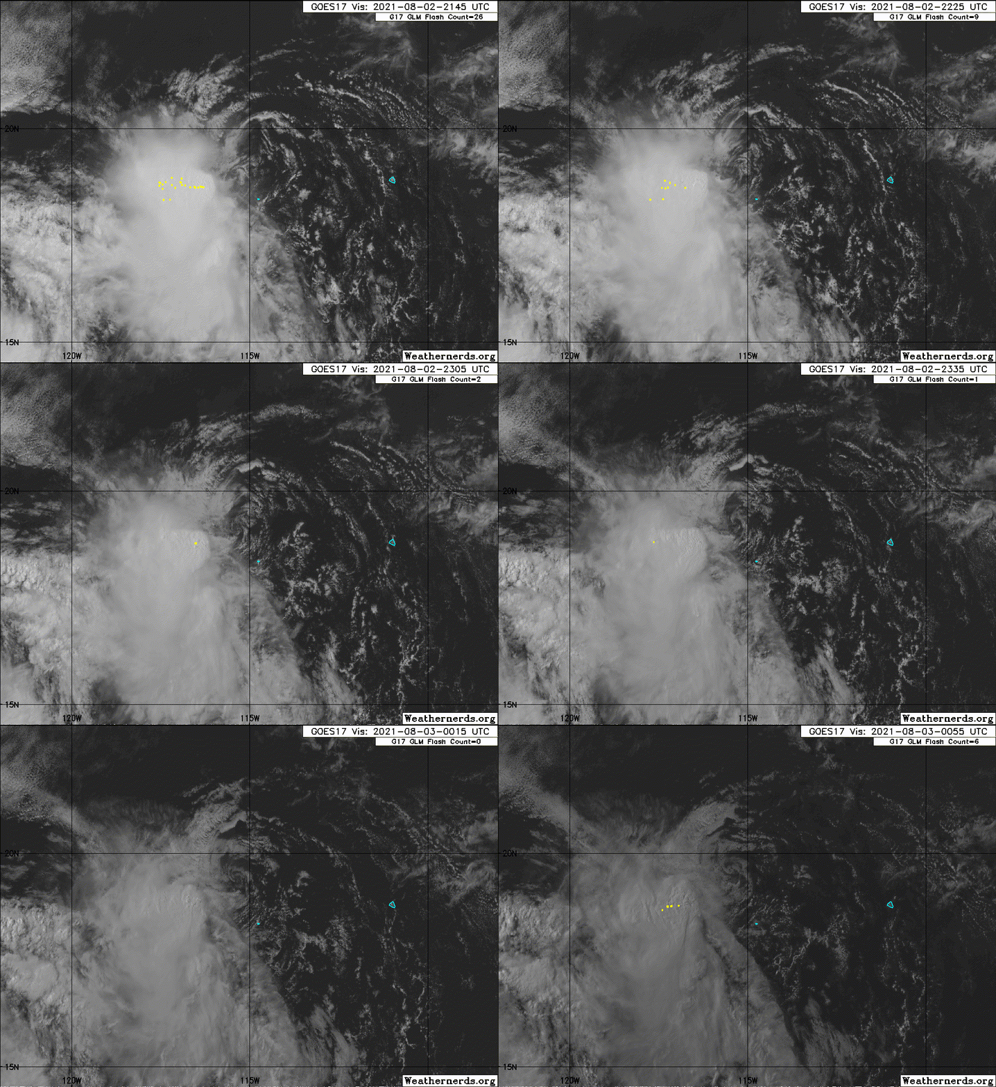
Ignacio appears to have peaked in intensity, with moderate-to-
strong northeasterly vertical wind shear having displaced most of
the deep convection into the southwestern semicircle of the
cyclone. The latest subjective satellite current intensity
estimates from TAFB and SAB remain at T2.5/35 kt, and objective
estimates from UW-CIMSS ADT and SATCON are 37 kt and 38 kt,
respectively. Based on these data, the intensity has been held at
35 kt, which could be generous. The center of Ignacio passed 15-20
nmi northeast of Clarion Island, Mexico, where the pressure fell to
1006.5 mb around 1400 UTC and the highest winds measured were
sustained 22 kt gusting to 33 kt according to a Mexican navy
observing station on the island. A pronounced wind shift from the
northeast to the southwest and west was also noted in the wind
data. However, wind speeds have been steadily decreasing over the
past several hours, an indication that the strongest winds are
likely occurring in the northeastern quadrant. Unfortunately, all
three ASCAT passes again missed the center and the strongest winds
associated with Ignacio.

The initial motion estimate is 300/08 kt. No significant changes
were required to the previous track forecast. Ignacio is forecast to
maintain a west-northwestward motion between a strong
mid-/upper-level ridge to the north and Hurricane Hilda to the
southwest throughout the short forecast period. The new advisory
track forecast is similar the previous forecast track, and lies
along the left side of the consensus track models envelope.

Ignacio is expected to gradually weaken during the next 48 hours due
to steadily increasing northeasterly vertical wind shear in excess
of 25 kt by 24 hours and beyond. By 18-24 hours, Ignacio will be
moving over sub-26C sea-surface temperatures, which will act to
hasten the weakening process, with dissipation expected by 60 hours,
if not sooner. The new NHC intensity forecast is similar to the
previous advisory and a blend of the NOAA-HCCA and IVCN consensus
intensity models.


FORECAST POSITIONS AND MAX WINDS

INIT 02/2100Z 18.8N 114.9W 35 KT 40 MPH
12H 03/0600Z 19.5N 116.0W 30 KT 35 MPH
24H 03/1800Z 20.4N 117.2W 25 KT 30 MPH
36H 04/0600Z 21.2N 118.1W 20 KT 25 MPH...POST-TROP/REMNT LOW
48H 04/1800Z 21.2N 118.9W 20 KT 25 MPH...POST-TROP/REMNT LOW
60H 05/0600Z...DISSIPATED

$$
Forecaster Stewart
0 likes   
Visit the Caribbean-Central America Weather Thread where you can find at first post web cams,radars
and observations from Caribbean basin members Click Here

User avatar
Yellow Evan
Professional-Met
Professional-Met
Posts: 15952
Age: 25
Joined: Fri Jul 15, 2011 12:48 pm
Location: Henderson, Nevada/Honolulu, HI
Contact:

Re: EPAC: IGNACIO - Tropical Storm

#42 Postby Yellow Evan » Mon Aug 02, 2021 7:18 pm

TXPZ21 KNES 022355
TCSENP

A. 10E (IGNACIO)

B. 02/2330Z

C. 19.1N

D. 115.3W

E. FIVE/GOES-W

F. T1.5/2.5

G. IR/EIR/VIS

H. REMARKS...SYSTEM HAS LOOSELY DEFINED CLOUD LINES AROUND AN EXPOSED
LLCC THAT IS LESS THAN 1.25 DEGREES FROM THE LARGE ACTIVE COLD OVERCAST
RESULTING IN A SHEAR PATTERN DT OF 1.5. THE 24 HR DEVELOPMENT TREND IS
WEAKENING SLOWLY RESULTING MET TO BE 1.5 AND PT TO BE 2.0. FT IS BASED
ON DT.

I. ADDL POSITIONS

NIL


...PATEL
0 likes   

Sciencerocks
Category 5
Category 5
Posts: 7286
Age: 38
Joined: Thu Jul 06, 2017 1:51 am

Re: EPAC: IGNACIO - Tropical Storm

#43 Postby Sciencerocks » Mon Aug 02, 2021 8:11 pm

Image
0 likes   

User avatar
cycloneye
Admin
Admin
Posts: 139089
Age: 67
Joined: Thu Oct 10, 2002 10:54 am
Location: San Juan, Puerto Rico

Re: EPAC: IGNACIO - Tropical Storm

#44 Postby cycloneye » Mon Aug 02, 2021 9:35 pm

Tropical Storm Ignacio Discussion Number 6
NWS National Hurricane Center Miami FL EP102021
800 PM PDT Mon Aug 02 2021

The low-level center of Ignacio is becoming even more separated from
the main area of deep convection as strong east-northeasterly shear
continue to affect the cyclone. The associated deep convection is
also shrinking in coverage. Dvorak Current Intensity numbers from
TAFB and SAB still give 35 kt, but that is probably a generous
estimate for the strength of the system given its disheveled
appearance.

Ignacio is moving northwestward, or about 310/8 kt. The cyclone is
expected to slow its forward speed while it nears a weakness between
two low- to mid-level anticyclones in a day or so. The track
guidance shows an eastward turn in 24-36 hours, but the system will
likely be influenced more by the weak surface flow, and move very
slowly, by that time. The official track forecast is shifted
eastward from the previous one, but is not nearly as far east as the
latest model consensus.

Ignacio is expected to move through an environment of strong shear
and over marginal SSTs through tomorrow. The model guidance is in
agreement that the cyclone will weaken to a depression on Tuesday,
and the global models show the system dissipating in 48 hours.
Given the current disorganizing trend, however, Ignacio may
degenerate even faster than shown here.


FORECAST POSITIONS AND MAX WINDS

INIT 03/0300Z 19.6N 115.7W 35 KT 40 MPH
12H 03/1200Z 20.3N 116.6W 30 KT 35 MPH
24H 04/0000Z 21.1N 117.4W 25 KT 30 MPH
36H 04/1200Z 21.6N 117.5W 20 KT 25 MPH...POST-TROP/REMNT LOW
48H 05/0000Z...DISSIPATED

$$
Forecaster Pasch
0 likes   
Visit the Caribbean-Central America Weather Thread where you can find at first post web cams,radars
and observations from Caribbean basin members Click Here

User avatar
Yellow Evan
Professional-Met
Professional-Met
Posts: 15952
Age: 25
Joined: Fri Jul 15, 2011 12:48 pm
Location: Henderson, Nevada/Honolulu, HI
Contact:

Re: EPAC: IGNACIO - Tropical Storm

#45 Postby Yellow Evan » Tue Aug 03, 2021 1:21 am

Image
0 likes   

User avatar
cycloneye
Admin
Admin
Posts: 139089
Age: 67
Joined: Thu Oct 10, 2002 10:54 am
Location: San Juan, Puerto Rico

Re: EPAC: IGNACIO - Tropical Depression

#46 Postby cycloneye » Tue Aug 03, 2021 4:30 am

Tropical Depression Ignacio Discussion Number 7
NWS National Hurricane Center Miami FL EP102021
200 AM PDT Tue Aug 03 2021

Strong east-northeasterly shear has continued to take a toll on
Ignacio overnight with a small cluster of remaining deep convection
now displaced over 60 n mi to the southwest of the center. An ASCAT
overpass that arrived shortly after the release of the previous
advisory indicates that Ignacio has weakened to a tropical
depression with peak winds of around 30 kt. That is also supported
by a blend of the latest Dvorak T- and CI-numbers from TAFB and SAB.
The strong shear and marginal SSTs should continue to cause gradual
weakening over the next 12-24 hours, and Ignacio is expected to
become a remnant low Tuesday night. The GFS, ECMWF, and UKMET all
show the remnant low opening up into a trough of low pressure
shortly thereafter, and so does the official forecast.

Ignacio is moving slower toward the northwest than before, or about
315/5 kt. A further reduction in forward speed is predicted over
the next 12-24 hours as Ignacio weakens and is steered by the weaker
low-level flow. The track guidance again suggests that the remnant
low will turn northeastward before dissipating, and the updated NHC
track forecast has been adjusted accordingly.


FORECAST POSITIONS AND MAX WINDS

INIT 03/0900Z 20.1N 116.3W 30 KT 35 MPH
12H 03/1800Z 20.9N 116.9W 25 KT 30 MPH
24H 04/0600Z 21.2N 116.6W 20 KT 25 MPH...POST-TROP/REMNT LOW
36H 04/1800Z...DISSIPATED

$$
Forecaster Brown
0 likes   
Visit the Caribbean-Central America Weather Thread where you can find at first post web cams,radars
and observations from Caribbean basin members Click Here

User avatar
cycloneye
Admin
Admin
Posts: 139089
Age: 67
Joined: Thu Oct 10, 2002 10:54 am
Location: San Juan, Puerto Rico

Re: EPAC: IGNACIO - Tropical Depression

#47 Postby cycloneye » Tue Aug 03, 2021 9:37 am

Tropical Depression Ignacio Discussion Number 8
NWS National Hurricane Center Miami FL EP102021
800 AM PDT Tue Aug 03 2021

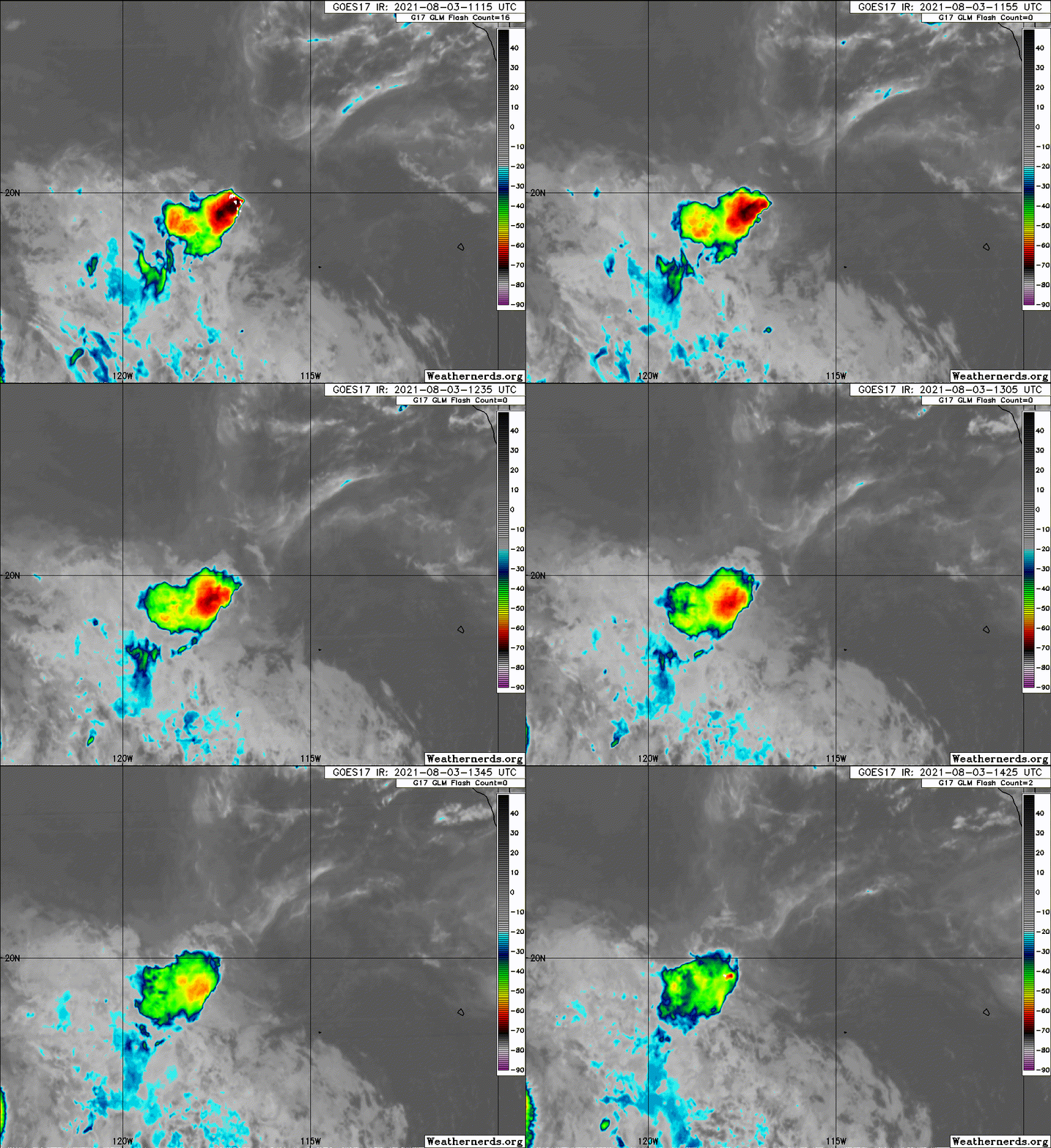
Strong east-northeasterly vertical wind shear of about 25 kt
continues across Ignacio, with only small cluster of weakening
thunderstorms located west of the fully exposed low-level
circulation center. Cloud tops have been steadily warming since the
previous advisory, and cloud-top temperatures are now barely -55C.
With the shear forecast to continue to increase while Ignacio moves
over sub-26-deg-C sea-surface temperatures by this afternoon,
regeneration of significant deep convection near the center appears
highly unlikely. As a result, Ignacio is forecast to degenerate into
a remnant low pressure system by this evening, if not sooner, with
dissipation expected on Wednesday.

The initial motion estimate is 335/05 kt. As Ignacio weakens
further and becomes more vertically shallow, the cyclone is expected
to meander within weak, low-level steering currents until the
system dissipates by 36 hours, if not earlier. The new NHC forecast
track is similar to the tightly clustered simple- and corrected-
consensus models, except for the earlier dissipation.


FORECAST POSITIONS AND MAX WINDS

INIT 03/1500Z 20.5N 116.7W 30 KT 35 MPH
12H 04/0000Z 20.9N 116.8W 25 KT 30 MPH...POST-TROP/REMNT LOW
24H 04/1200Z 20.6N 116.0W 20 KT 25 MPH...POST-TROP/REMNT LOW
36H 05/0000Z...DISSIPATED

$$
Forecaster Stewart
0 likes   
Visit the Caribbean-Central America Weather Thread where you can find at first post web cams,radars
and observations from Caribbean basin members Click Here

Sciencerocks
Category 5
Category 5
Posts: 7286
Age: 38
Joined: Thu Jul 06, 2017 1:51 am

Re: EPAC: IGNACIO - Tropical Depression

#48 Postby Sciencerocks » Tue Aug 03, 2021 9:38 am

Image
0 likes   

Sciencerocks
Category 5
Category 5
Posts: 7286
Age: 38
Joined: Thu Jul 06, 2017 1:51 am

Re: EPAC: IGNACIO - Tropical Depression

#49 Postby Sciencerocks » Tue Aug 03, 2021 2:48 pm

Image
0 likes   

User avatar
cycloneye
Admin
Admin
Posts: 139089
Age: 67
Joined: Thu Oct 10, 2002 10:54 am
Location: San Juan, Puerto Rico

Re: EPAC: IGNACIO - Tropical Depression

#50 Postby cycloneye » Tue Aug 03, 2021 3:44 pm

Tropical Depression Ignacio Discussion Number 9
NWS National Hurricane Center Miami FL EP102021
200 PM PDT Tue Aug 03 2021

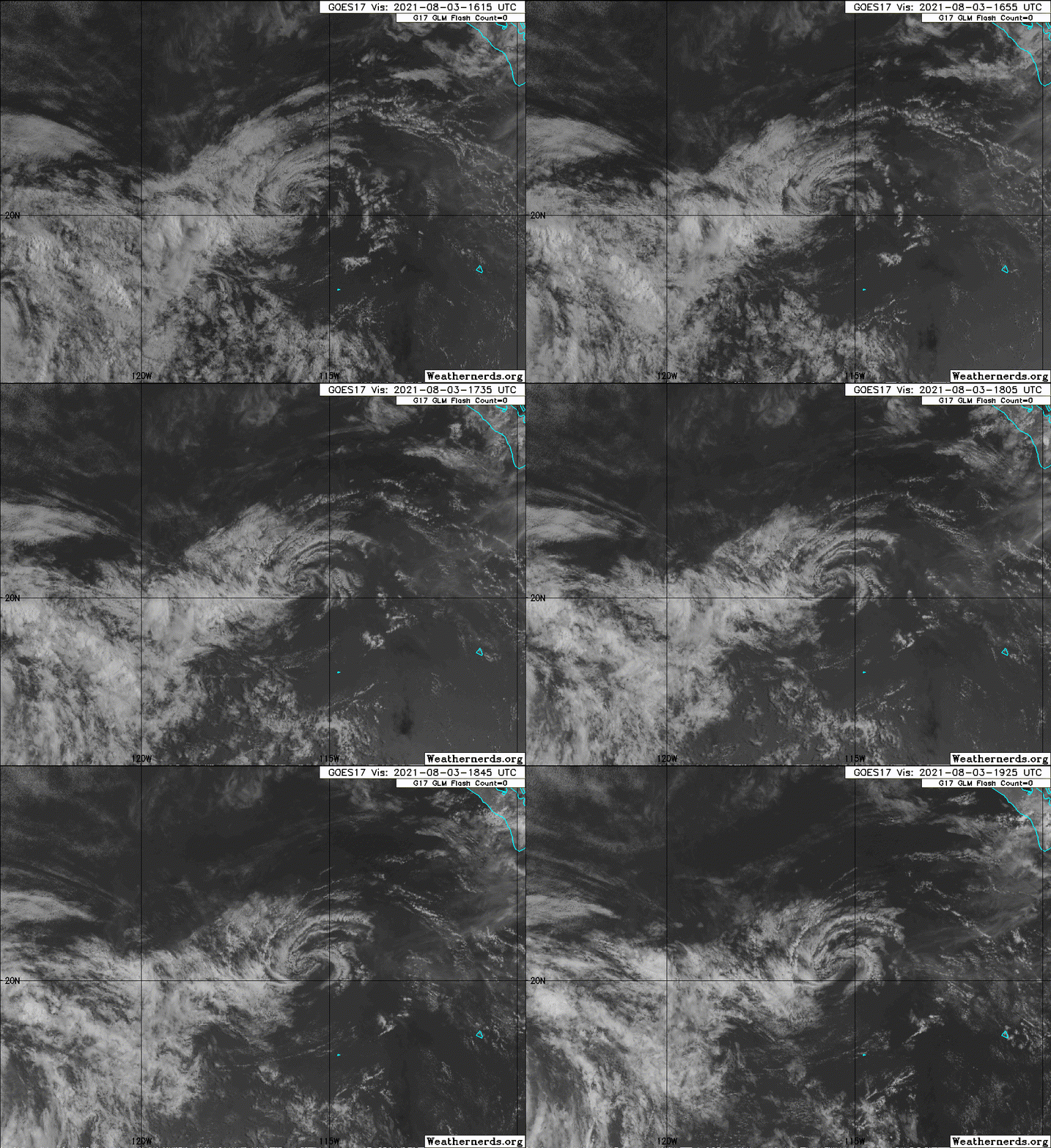
Ignacio has been devoid of deep convection within 75 nmi of the
center for the more than 6 hours now due to strong easterly vertical
wind shear. The initial intensity has been lowered to 25 kt based on
the continued degradation in the convective pattern and a 1536Z
ASCAT-A scatterometer pass that revealed a patch of 27-kt surface
wind vectors south of the center. The small cyclone is expected to
meander over water temperatures near 26 deg C for the next 12-24
hours, while the shear is forecast to increase to near 30 kt during
that time. Owing to these unfavorable environmental conditions,
Ignacio is forecast to degenerate into a remnant low pressure system
by late this afternoon, followed by dissipation on Wednesday.

The initial motion estimate is now 090/03 kt. Ignacio is forecast to
make a small clockwise loop within weak low-level steering flow
until the system dissipates around 36 hours. The new NHC official
track forecast is similar to the previous advisory track, and lies
close to the tightly clustered simple- and corrected-consensus
models.


FORECAST POSITIONS AND MAX WINDS

INIT 03/2100Z 20.4N 115.7W 25 KT 30 MPH
12H 04/0600Z 20.4N 115.3W 25 KT 30 MPH...POST-TROP/REMNT LOW
24H 04/1800Z 19.9N 114.5W 20 KT 25 MPH...POST-TROP/REMNT LOW
36H 05/0600Z...DISSIPATED

$$
Forecaster Stewart
0 likes   
Visit the Caribbean-Central America Weather Thread where you can find at first post web cams,radars
and observations from Caribbean basin members Click Here

Sciencerocks
Category 5
Category 5
Posts: 7286
Age: 38
Joined: Thu Jul 06, 2017 1:51 am

Re: EPAC: IGNACIO - Tropical Depression

#51 Postby Sciencerocks » Tue Aug 03, 2021 7:09 pm

Image
0 likes   

User avatar
cycloneye
Admin
Admin
Posts: 139089
Age: 67
Joined: Thu Oct 10, 2002 10:54 am
Location: San Juan, Puerto Rico

Re: EPAC: IGNACIO - Remnants

#52 Postby cycloneye » Tue Aug 03, 2021 9:38 pm

Post-Tropical Cyclone Ignacio Discussion Number 10
NWS National Hurricane Center Miami FL EP102021
800 PM PDT Tue Aug 03 2021

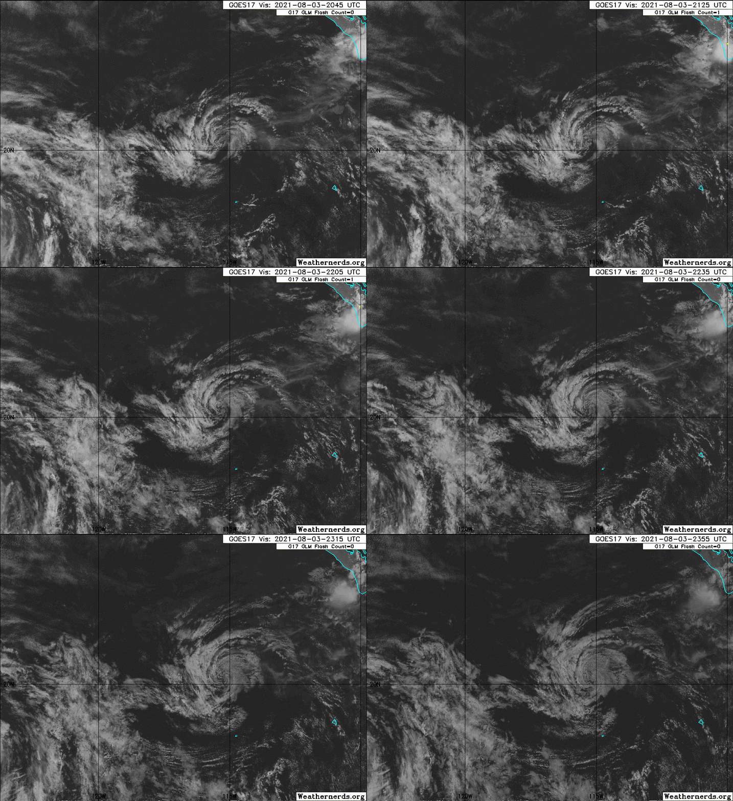
Ignacio consists of a swirl of low-level clouds and has been devoid
of deep convection anywhere near its center since this morning.
Therefore the system no longer qualifies as a tropical cyclone and
is now a remnant low, or a post-tropical cyclone.

The low has been moving east-southeastward, or about 120/6 kt. A
turn toward the southeast and south is expected on Wednesday while
the system moves around the northern side of a low-level ridge.

Although the low will be moving over slightly warmer waters, strong
easterly shear should prevent regeneration, and the system should
dissipate in 24 h or so.

This is the last advisory issued by the National Hurricane Center
on Ignacio. For additional information on the remnant low please
see High Seas Forecasts issued by the National Weather Service,
under AWIPS header NFDHSFEPI, WMO header FZPN02 KWBC, and on the web
at ocean.weather.gov/shtml/NFDHSFEPI.php


FORECAST POSITIONS AND MAX WINDS

INIT 04/0300Z 20.1N 115.0W 25 KT 30 MPH...POST-TROPICAL
12H 04/1200Z 19.6N 114.6W 20 KT 25 MPH...POST-TROP/REMNT LOW
24H 05/0000Z...DISSIPATED

$$
Forecaster Pasch
0 likes   
Visit the Caribbean-Central America Weather Thread where you can find at first post web cams,radars
and observations from Caribbean basin members Click Here


Return to “2021”

Who is online

Users browsing this forum: No registered users and 68 guests