weeniepatrol wrote:https://imgur.com/FqHb0ry
She's starting to look decent.
Moderator: S2k Moderators


panamatropicwatch wrote:850mb vorticity is increasing near Colombia.
http://tropic.ssec.wisc.edu/real-time/windmain.php?&basin=atlantic&sat=wg8&prod=vor&zoom=&time=
GCANE wrote:This is forecast to entrain a massive amount of high TPW air from the EPAC.
Not only coming across Panama but Nic and CR as well.
This is very rare.
If it doesn't cross the Yucatan and rain some of this out, it will be packing a massive punch.
[url]https://i.postimg.cc/DZ2b0JC9/99L1.png [/url]
[url]https://i.postimg.cc/W40HjKK9/99L2.png [/url]
jasons2k wrote:Morning update from Jeff Lindner:
Potential hurricane threat for the western and northwestern Gulf of Mexico early next week.
Tropical wave is moving westward over the extreme southern Caribbean Sea along the northern coast of South America this morning. There is scattered convection in association with the wave axis, but no low level center. Global model guidance continues to indicate that surface low pressure will develop over some portion of the western Caribbean Sea either Friday or Saturday and move WNW or NW into the south-central Gulf of Mexico over the weekend.
There has been a significant shift in the deterministic model guidance over the last 24 hours to the right (east) with the majority of the guidance showing 99L heading in the direction of the NW Gulf of Mexico. While there has been some significant shifts in the deterministic runs of the models, the ensemble members continue to show a wide range of potential solutions from northern MX to the MS coast. Generally, the ensemble mean or average is to the left of the deterministic guidance runs. This creates a fair amount of uncertainty in the forecast, especially since there is such spread in the ensemble guidance. A lot of the guidance spread is resulting from the lack of a define surface center currently, and it will be critically important late this week on where the actual surface center develops.
Conditions over the Gulf of Mexico appear to be favorable for intensification and nearly all of the global guidance makes 99L a hurricane and some an intense hurricane over the NW Gulf of Mexico early next week.
It is too early to start discussing impacts since there remains a fair amount of uncertainty on the track. For now will continue to bump up seas by this weekend across our coastal waters…likely into the 10-15 foot range by Sunday into Monday and increasing tides. Rain chances will increase starting today and remain high into the weekend. Obviously, the forecast and potential impacts will have significant changes as the track become more clear in the coming days.
Residents and interest along the TX and LA coast should review hurricane plans and make sure hurricane supplies are fully stocked. Monitor forecasts closely and frequently.
Blinhart wrote:
Looks like a very healthy wave right now, luckily from what I could tell no CoC yet.
GCANE wrote:Blinhart wrote:
Looks like a very healthy wave right now, luckily from what I could tell no CoC yet.
On VIS I am seeing some to the east moving clouds, not sure at what level they are.
One tower is firing near this with a little bit of helicity.
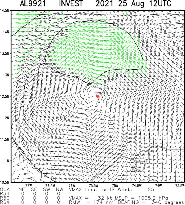
GCANE wrote:Multi IR-Sat LL wind analysis
[url]https://i.postimg.cc/KYKbw6ph/2021al99-mpsatwnd-202108251200-swhr.gif [/url]pictures hoster
GCANE wrote:Multi IR-Sat LL wind analysis
[url]https://i.postimg.cc/KYKbw6ph/2021al99-mpsatwnd-202108251200-swhr.gif [/url]pictures hoster


Blinhart wrote:jasons2k wrote:Morning update from Jeff Lindner:
Potential hurricane threat for the western and northwestern Gulf of Mexico early next week.
Tropical wave is moving westward over the extreme southern Caribbean Sea along the northern coast of South America this morning. There is scattered convection in association with the wave axis, but no low level center. Global model guidance continues to indicate that surface low pressure will develop over some portion of the western Caribbean Sea either Friday or Saturday and move WNW or NW into the south-central Gulf of Mexico over the weekend.
There has been a significant shift in the deterministic model guidance over the last 24 hours to the right (east) with the majority of the guidance showing 99L heading in the direction of the NW Gulf of Mexico. While there has been some significant shifts in the deterministic runs of the models, the ensemble members continue to show a wide range of potential solutions from northern MX to the MS coast. Generally, the ensemble mean or average is to the left of the deterministic guidance runs. This creates a fair amount of uncertainty in the forecast, especially since there is such spread in the ensemble guidance. A lot of the guidance spread is resulting from the lack of a define surface center currently, and it will be critically important late this week on where the actual surface center develops.
Conditions over the Gulf of Mexico appear to be favorable for intensification and nearly all of the global guidance makes 99L a hurricane and some an intense hurricane over the NW Gulf of Mexico early next week.
It is too early to start discussing impacts since there remains a fair amount of uncertainty on the track. For now will continue to bump up seas by this weekend across our coastal waters…likely into the 10-15 foot range by Sunday into Monday and increasing tides. Rain chances will increase starting today and remain high into the weekend. Obviously, the forecast and potential impacts will have significant changes as the track become more clear in the coming days.
Residents and interest along the TX and LA coast should review hurricane plans and make sure hurricane supplies are fully stocked. Monitor forecasts closely and frequently.
Yeah I think all offshore rigs should be starting to Evacuate today, that way they are completely evacuated by Saturday.

SoupBone wrote:GCANE wrote:Multi IR-Sat LL wind analysis
[url]https://i.postimg.cc/KYKbw6ph/2021al99-mpsatwnd-202108251200-swhr.gif [/url]pictures hoster
With those wind directions, what would this be classified as? A center?
Users browsing this forum: No registered users and 25 guests