EPAC: PAMELA - Remnants

Moderator: S2k Moderators

Message
Author
User avatar
Yellow Evan
Professional-Met
Professional-Met
Posts: 15952
Age: 25
Joined: Fri Jul 15, 2011 12:48 pm
Location: Henderson, Nevada/Honolulu, HI
Contact:

Re: EPAC: INVEST 91E

#21 Postby Yellow Evan » Fri Oct 08, 2021 5:17 pm

Image

Image

12z ECMWF has the center forming around 97W-100W and becoming dominant, which would explain the track difference. (12z ECMWF has this consolidating so far west that it doesn’t feel the weakness until around 115W or so before recurving and moving over Baja) Of course, that wouldn’t explain the intensity difference. I will say the GEFS (which is pretty bad in this basin) is closer to many of the ECMWF runs than the GFS in terms of track, so I wouldn’t dismiss this completely.
0 likes   

User avatar
aspen
Category 5
Category 5
Posts: 8057
Joined: Sat Oct 12, 2019 7:10 pm
Location: Connecticut, USA

Re: EPAC: INVEST 91E

#22 Postby aspen » Fri Oct 08, 2021 5:50 pm

18z GFS is a little weaker, with a mid-950s Cat 3/4 that weakens to a lower end Cat 3 right before landfall.
0 likes   
Irene '11 Sandy '12 Hermine '16 5/15/2018 Derecho Fay '20 Isaias '20 Elsa '21 Henri '21 Ida '21

I am only a meteorology enthusiast who knows a decent amount about tropical cyclones. Look to the professional mets, the NHC, or your local weather office for the best information.

User avatar
aspen
Category 5
Category 5
Posts: 8057
Joined: Sat Oct 12, 2019 7:10 pm
Location: Connecticut, USA

Re: EPAC: INVEST 91E

#23 Postby aspen » Fri Oct 08, 2021 6:14 pm

18z HWRF is running and has TS Pamela by tomorrow night or early Sunday morning, showing a lot of new convection popping up over the next 12-18 hours.
0 likes   
Irene '11 Sandy '12 Hermine '16 5/15/2018 Derecho Fay '20 Isaias '20 Elsa '21 Henri '21 Ida '21

I am only a meteorology enthusiast who knows a decent amount about tropical cyclones. Look to the professional mets, the NHC, or your local weather office for the best information.

User avatar
cycloneye
Admin
Admin
Posts: 139086
Age: 67
Joined: Thu Oct 10, 2002 10:54 am
Location: San Juan, Puerto Rico

Re: EPAC: INVEST 91E

#24 Postby cycloneye » Fri Oct 08, 2021 6:57 pm

Tropical Weather Outlook
NWS National Hurricane Center Miami FL
500 PM PDT Fri Oct 8 2021

For the eastern North Pacific...east of 140 degrees west longitude:

1. Recent satellite images indicate that a broad area of low pressure
has formed a few hundred miles south-southeast of Tehuantepec,
Mexico. However, the associated shower and thunderstorm activity is
currently disorganized. Environmental conditions are forecast to be
conducive for development, and a tropical depression or tropical
storm is expected to form by late this weekend or early next week
while the system moves westward to west-northwestward at about 15
mph south of the coast of Mexico.
* Formation chance through 48 hours...high...70 percent.
* Formation chance through 5 days...high...90 percent.

Forecaster Latto
0 likes   
Visit the Caribbean-Central America Weather Thread where you can find at first post web cams,radars
and observations from Caribbean basin members Click Here

Astromanía
Category 2
Category 2
Posts: 737
Age: 25
Joined: Sat Aug 25, 2018 10:34 pm
Location: Monterrey, N.L, México

Re: EPAC: INVEST 91E

#25 Postby Astromanía » Fri Oct 08, 2021 7:16 pm

This is the type of Epac system that could bring needed rain to my area but at the same time the type of system that could destroy a populous city in western Mexico as Mazatlan, San Blas, Manzanillo or Puerto Vallarta
0 likes   

User avatar
cycloneye
Admin
Admin
Posts: 139086
Age: 67
Joined: Thu Oct 10, 2002 10:54 am
Location: San Juan, Puerto Rico

Re: EPAC: INVEST 91E

#26 Postby cycloneye » Fri Oct 08, 2021 7:47 pm

947 mbs on HWRF just south of Cabo San Lucas.

Image
0 likes   
Visit the Caribbean-Central America Weather Thread where you can find at first post web cams,radars
and observations from Caribbean basin members Click Here

User avatar
aspen
Category 5
Category 5
Posts: 8057
Joined: Sat Oct 12, 2019 7:10 pm
Location: Connecticut, USA

Re: EPAC: INVEST 91E

#27 Postby aspen » Fri Oct 08, 2021 7:50 pm

HMON and HWRF are much further west and north than the GFS, and would keep Pamela further from the warmest waters before it gets sheared. So either it takes the further west track and becomes a low-end Cat 4 at most that (hopefully) weakens before landfall, or it takes the further east GFS track and goes bonkers.

Also, the HWRF-P shows that Pamela will be very quickly upwelling cold waters the moment it goes sub-960.
0 likes   
Irene '11 Sandy '12 Hermine '16 5/15/2018 Derecho Fay '20 Isaias '20 Elsa '21 Henri '21 Ida '21

I am only a meteorology enthusiast who knows a decent amount about tropical cyclones. Look to the professional mets, the NHC, or your local weather office for the best information.

User avatar
Yellow Evan
Professional-Met
Professional-Met
Posts: 15952
Age: 25
Joined: Fri Jul 15, 2011 12:48 pm
Location: Henderson, Nevada/Honolulu, HI
Contact:

Re: EPAC: INVEST 91E

#28 Postby Yellow Evan » Fri Oct 08, 2021 8:13 pm

18z HWRF has this past 100W by 0z on Sunday. Much closer to the ECMWF than the GFS in that regard which has this around 97W. Also worth noting that SST can easily support a Category 5 hurricane as long as they are at minimum 28C, which extend well past 115W.
0 likes   

User avatar
Yellow Evan
Professional-Met
Professional-Met
Posts: 15952
Age: 25
Joined: Fri Jul 15, 2011 12:48 pm
Location: Henderson, Nevada/Honolulu, HI
Contact:

Re: EPAC: INVEST 91E

#29 Postby Yellow Evan » Fri Oct 08, 2021 8:22 pm

* GFS version *
* EAST PACIFIC 2021 SHIPS INTENSITY FORECAST *
* IR SAT DATA AVAILABLE, OHC AVAILABLE *
* INVEST EP912021 10/09/21 00 UTC *

TIME (HR) 0 6 12 18 24 36 48 60 72 84 96 108 120 132 144 156 168
V (KT) NO LAND 30 33 36 39 43 49 58 67 74 75 80 81 68 58 56 53 49
V (KT) LAND 30 33 36 39 43 49 58 67 74 75 80 81 68 39 31 28 27
V (KT) LGEM 30 34 36 39 41 44 50 55 60 64 70 73 65 38 30 28 27
Storm Type TROP TROP TROP TROP TROP TROP TROP TROP TROP TROP TROP TROP TROP TROP TROP TROP TROP

SHEAR (KT) 15 12 14 16 16 10 8 8 8 11 7 12 26 27 28 26 35
SHEAR ADJ (KT) 0 1 1 2 1 4 6 2 -4 -2 -2 0 1 -4 5 9 0
SHEAR DIR 31 39 24 37 30 18 346 332 336 301 223 195 181 233 255 250 236
SST (C) 29.3 29.5 29.4 29.3 29.4 29.1 29.8 30.5 30.8 30.1 29.8 30.7 31.2 28.5 28.6 28.6 28.5
POT. INT. (KT) 160 161 160 159 159 156 164 171 171 165 162 172 172 151 151 149 147
200 MB T (C) -52.1 -52.7 -53.0 -52.8 -52.6 -53.1 -52.5 -52.6 -52.4 -52.7 -52.1 -52.4 -51.5 -51.8 -51.5 -51.9 -52.6
200 MB VXT (C) 0.0 0.1 0.1 0.1 0.1 0.2 0.2 0.2 0.5 0.5 0.5 0.7 0.5 0.5 0.0 0.0 0.0
TH_E DEV (C) 5 4 4 4 5 5 8 7 7 6 7 6 9 6 11 7 8
700-500 MB RH 72 73 73 72 71 70 66 67 68 66 64 54 44 38 33 35 40
MODEL VTX (KT) 8 9 10 11 12 13 15 17 18 18 21 22 12 5 LOST LOST LOST
850 MB ENV VOR 29 15 12 16 11 11 19 16 8 -5 11 42 56 52 8 27 9
200 MB DIV 57 78 110 121 119 102 101 68 94 57 59 76 78 0 7 21 29
700-850 TADV -4 -1 -1 0 -1 -3 -9 -11 -5 -5 0 -3 -10 10 9 6 -11
LAND (KM) 529 592 572 540 519 504 496 458 416 373 284 146 13 -261 -407 -205 -109
LAT (DEG N) 10.0 10.3 10.6 11.1 11.5 12.5 13.6 14.8 16.2 17.5 18.9 20.4 22.3 xx.x xx.x xx.x xx.x
LONG(DEG W) 94.1 95.6 96.9 98.2 99.3 101.4 103.6 105.6 107.1 107.9 107.9 107.1 105.8 xxx.x xxx.x xxx.x xxx.x
STM SPEED (KT) 16 14 13 13 11 12 12 11 8 7 7 10 12 14 12 7 5
HEAT CONTENT 12 14 15 17 19 18 27 24 29 24 21 43 41 14 5 3 3

FORECAST TRACK FROM TABM INITIAL HEADING/SPEED (DEG/KT):275/ 17 CX,CY: -16/ 1
T-12 MAX WIND: 20 PRESSURE OF STEERING LEVEL (MB): 433 (MEAN=587)
GOES IR BRIGHTNESS TEMP. STD DEV. 50-200 KM RAD: 20.7 (MEAN=14.5)
% GOES IR PIXELS WITH T < -20 C 50-200 KM RAD: 48.0 (MEAN=65.0)
PRELIM RI PROB (DV .GE. 35 KT IN 36 HR): 20.5

INDIVIDUAL CONTRIBUTIONS TO INTENSITY CHANGE
6 12 18 24 36 48 60 72 84 96 108 120 132 144 156 168
------------------------------------------------------------------------------
SAMPLE MEAN CHANGE 0. 0. 1. 1. 1. 2. 1. 1. 0. -0. -1. -2. -2. -3. -4. -4.
SST POTENTIAL -0. -0. -0. 1. 5. 11. 18. 24. 29. 32. 35. 39. 42. 44. 46. 48.
VERTICAL SHEAR MAG 0. 1. 1. 1. 1. 1. 1. 1. 1. 1. 1. -0. -2. -6. -10. -14.
VERTICAL SHEAR ADJ 0. -0. -0. -0. -0. -1. -1. -1. -0. -0. -0. -0. -0. -0. -0. -0.
VERTICAL SHEAR DIR 0. 1. 2. 2. 4. 4. 3. 3. 2. 1. 0. 0. 0. 1. 1. 1.
PERSISTENCE 2. 3. 3. 4. 3. 3. 3. 2. 2. 2. 2. 2. 2. 2. 2. 2.
200/250 MB TEMP. -0. -0. -0. -1. -1. -1. -2. -3. -3. -2. -2. -1. 0. 0. 0. -0.
THETA_E EXCESS -0. -1. -1. -1. -2. -2. -1. -1. -1. -1. -1. -0. -0. 1. 1. 1.
700-500 MB RH 0. 0. 0. 0. 1. 1. 1. 1. 1. 1. 1. 1. 0. 0. -0. -1.
MODEL VTX TENDENCY 0. 1. 2. 3. 3. 7. 11. 14. 14. 17. 17. 4. -4. -4. -4. -3.
850 MB ENV VORTICITY -0. -0. -0. -0. -0. 0. 0. 0. 0. 0. 0. 0. 0. 0. 0. 0.
200 MB DIVERGENCE 0. 0. 1. 1. 2. 2. 4. 5. 5. 5. 5. 4. 2. 1. -0. -1.
850-700 T ADVEC 0. 0. 0. 0. 0. -0. -0. -0. -0. -0. -0. -0. -1. -1. -0. -1.
ZONAL STORM MOTION 0. 1. 1. 2. 3. 4. 4. 4. 3. 3. 3. 3. 2. 2. 1. -0.
STEERING LEVEL PRES -0. -0. -1. -1. -2. -2. -2. -2. -3. -3. -3. -3. -3. -2. -2. -1.
DAYS FROM CLIM. PEAK -0. -0. -0. -0. -0. -0. -0. -1. -1. -1. -2. -2. -2. -2. -3. -4.
GOES PREDICTORS -0. -1. -1. -1. -1. -2. -3. -4. -4. -5. -5. -6. -6. -5. -4. -4.
OCEAN HEAT CONTENT -0. -0. -0. -0. -0. -0. 0. 0. 0. 0. -0. -0. -1. -1. -1. -1.
RI POTENTIAL 0. 1. 1. 2. 3. 2. 1. 0. -0. -0. -1. -1. -0. -0. -0. -0.
------------------------------------------------------------------------------
TOTAL CHANGE 3. 6. 9. 13. 19. 28. 37. 44. 45. 50. 51. 38. 28. 26. 23. 19.

CURRENT MAX WIND (KT): 30. LAT, LON: 10.0 94.1

** 2021 E. Pacific RI INDEX EP912021 INVEST 10/09/21 00 UTC **
(SHIPS-RII PREDICTOR TABLE for 30 KT OR MORE MAXIMUM WIND INCREASE IN NEXT 24-h)

Predictor Value RI Predictor Range Scaled Value(0-1) % Contribution
POT = MPI-VMAX (KT) : 130.0 40.5 to 149.3 0.82 6.2
12 HR PERSISTENCE (KT) : 10.0 -22.0 to 44.0 0.48 4.2
D200 (10**7s-1) : 97.0 -33.0 to 159.5 0.68 4.7
850-200 MB SHEAR (KT) : 14.7 19.6 to 1.3 0.27 1.8
MAXIMUM WIND (KT) : 30.0 22.5 to 132.0 0.21 1.1
STD DEV OF IR BR TEMP : 20.7 37.8 to 2.1 0.48 2.3
BL DRY-AIR FLUX (W/M2) : 53.8 800.8 to -82.5 0.85 -4.5
HEAT CONTENT (KJ/CM2) : 15.4 2.7 to 106.7 0.12 0.5
%area of TPW <45 mm upshear : 0.0 56.6 to 0.0 1.00 1.5
2nd PC OF IR BR TEMP : 0.1 2.2 to -2.3 0.47 0.4

SHIPS Prob RI for 20kt/ 12hr RI threshold= 8% is 1.3 times climatological mean ( 6.3%)
SHIPS Prob RI for 25kt/ 24hr RI threshold= 21% is 1.7 times climatological mean (12.5%)
SHIPS Prob RI for 30kt/ 24hr RI threshold= 18% is 2.1 times climatological mean ( 8.6%)
SHIPS Prob RI for 35kt/ 24hr RI threshold= 17% is 2.8 times climatological mean ( 6.2%)
SHIPS Prob RI for 40kt/ 24hr RI threshold= 0% is 0.0 times climatological mean ( 4.2%)
SHIPS Prob RI for 45kt/ 36hr RI threshold= 18% is 2.7 times climatological mean ( 6.7%)
SHIPS Prob RI for 55kt/ 48hr RI threshold= 20% is 3.3 times climatological mean ( 5.9%)
SHIPS Prob RI for 65kt/ 72hr RI threshold= 46% is 9.7 times climatological mean ( 4.7%)

Matrix of RI probabilities
------------------------------------------------------------------------------
RI (kt / h) | 20/12 | 25/24 | 30/24 | 35/24 | 40/24 | 45/36 | 55/48 |65/72
------------------------------------------------------------------------------
SHIPS-RII: 8.3% 21.3% 18.2% 17.3% 0.0% 18.4% 19.7% 45.6%
Logistic: 1.5% 15.2% 5.2% 3.2% 0.7% 11.1% 18.8% 33.0%
Bayesian: 0.0% 0.9% 0.3% 0.1% 0.0% 0.0% 0.1% 2.7%
Consensus: 3.3% 12.4% 7.9% 6.9% 0.3% 9.8% 12.9% 27.1%
DTOPS: 999.0% 999.0% 999.0% 999.0% 999.0% 999.0% 999.0% 999.0%

## ANNULAR HURRICANE INDEX (AHI) EP912021 INVEST 10/09/21 00 UTC ##
## STORM NOT ANNULAR, SCREENING STEP FAILED, NPASS=3 NFAIL=4 ##
## AHI= 0 (AHI OF 100 IS BEST FIT TO ANN. STRUC., 1 IS MARGINAL, 0 IS NOT ANNULAR) ##
0 likes   

User avatar
Yellow Evan
Professional-Met
Professional-Met
Posts: 15952
Age: 25
Joined: Fri Jul 15, 2011 12:48 pm
Location: Henderson, Nevada/Honolulu, HI
Contact:

Re: EPAC: INVEST 91E

#30 Postby Yellow Evan » Fri Oct 08, 2021 8:38 pm

Image

Image

Another difference between the GFS and ECMWF appears to be related the strength of the ridge, which is why the GFS has it going much more poleward and recurving quickly.

Image
0 likes   

User avatar
Ubuntwo
Category 5
Category 5
Posts: 1089
Age: 30
Joined: Thu Oct 05, 2017 10:41 pm

Re: EPAC: INVEST 91E

#31 Postby Ubuntwo » Fri Oct 08, 2021 9:08 pm

Yellow Evan wrote:Another difference between the GFS and ECMWF appears to be related the strength of the ridge, which is why the GFS has it going much more poleward and recurving quickly.

On top of synoptic differences, differing intensity between the models explains some of the track divergence. Steering for a stronger system is both weaker (slower) and more poleward.
Image
As a result, GFS runs with a cat 3/4 vs. a 5 make landfall sooner.

While the Euro never develops a proper anticyclone over 91E leading to a sheared, struggling system (maybe a function of developing a different lobe of the monsoon trough?) Hmm... guess we'll see in a couple days.
2 likes   
Kendall -> SLO -> PBC

Memorable Storms: Katrina (for its Florida landfall...) Wilma Matthew Irma

User avatar
Yellow Evan
Professional-Met
Professional-Met
Posts: 15952
Age: 25
Joined: Fri Jul 15, 2011 12:48 pm
Location: Henderson, Nevada/Honolulu, HI
Contact:

Re: EPAC: INVEST 91E

#32 Postby Yellow Evan » Fri Oct 08, 2021 11:10 pm

0z GFS has a clear low forming at 97W in 12 hours, so no change from previous run. This seems realistic based on its current motion. Initialization may be a hair too east, however. If this busts to its west, I’ll be less confident in the GFS’s handle of the storm, especially if this system simply does not organize rapidly tomorrow as expected.
0 likes   

Sciencerocks
Category 5
Category 5
Posts: 7286
Age: 38
Joined: Thu Jul 06, 2017 1:51 am

Re: EPAC: INVEST 91E

#33 Postby Sciencerocks » Sat Oct 09, 2021 2:02 am

Image
0 likes   

User avatar
aspen
Category 5
Category 5
Posts: 8057
Joined: Sat Oct 12, 2019 7:10 pm
Location: Connecticut, USA

Re: EPAC: INVEST 91E

#34 Postby aspen » Sat Oct 09, 2021 6:32 am

It seems that, depending on its track, Pamela will either end up as a run-of-the-mill EPac major, or Patricia Lite. Both scenarios likely involve weakening before landfall as Pamela’s orientation with the jet to its north starts shearing it instead of ventilating it, so Mexico hopefully won’t get the full force of this storm.

In the last two runs, the HWRF has shown an EWRC or an eyewall meld as Pamela makes its turn towards Mexico, which could put a cap on its intensity and cause it to weaken even more before landfall IF it verifies.
1 likes   
Irene '11 Sandy '12 Hermine '16 5/15/2018 Derecho Fay '20 Isaias '20 Elsa '21 Henri '21 Ida '21

I am only a meteorology enthusiast who knows a decent amount about tropical cyclones. Look to the professional mets, the NHC, or your local weather office for the best information.

User avatar
aspen
Category 5
Category 5
Posts: 8057
Joined: Sat Oct 12, 2019 7:10 pm
Location: Connecticut, USA

Re: EPAC: INVEST 91E

#35 Postby aspen » Sat Oct 09, 2021 7:52 am

The 06z HWRF/HMON and 00z HWRF-P aren’t loading on Tropical Tidbits. However, the 06z track guidance graphic shows the HWRF has shifted a little to the east.

Up to 80/90 on the 8am TWO.

The CIMSS page for 91E shows MPIs all the way into the sub-875mb range in part of Pamela’s future track. If it gets its core going fast enough, it could explode well before landfall and have enough time to weaken, although so far it doesn’t look any closer to developing than it did 12 hours ago.
3 likes   
Irene '11 Sandy '12 Hermine '16 5/15/2018 Derecho Fay '20 Isaias '20 Elsa '21 Henri '21 Ida '21

I am only a meteorology enthusiast who knows a decent amount about tropical cyclones. Look to the professional mets, the NHC, or your local weather office for the best information.

zeehag
Tropical Storm
Tropical Storm
Posts: 172
Age: 75
Joined: Sun Jul 17, 2011 9:49 pm
Location: mazatlan,sinaloa, mexico, fixing patricia's mess.
Contact:

Re: EPAC: INVEST 91E

#36 Postby zeehag » Sat Oct 09, 2021 8:03 am

skyline385 wrote:
zeehag wrote:and so we have another letter P for october mayhem. and it seems to be acomin my way yet again. .i can wish it on my friends in barra or i can wish it on my friends in san blas or i can wish it on banderas bay, but this issue will leave a dent. hoping not for a patricia repeat. i havebeen hoping the models i have seen which are way to early and premature are more accurate than not..
seems to be near anniversary of patricias nastiness in barra.. that was an experience.. beautiful storm but wow.

From what i have read, Patricia wasnt that bad at all because of the evacuations and the super rapid weakening because of it's tiny core.

so you are telling us the intensifying cat 5 that felt like a cat 7 whose eyewall was over my boat in barra de navidad marina which is in colimilla with 215 mph winds and 250 mphj gusts and my cracked mizzen was a nothingburger?? hahahahahahaha guess again. but i guess ye had to be there in the wind and rain to understand it was a real cat 5 plus hit with all the trimmings. tell the farmers of colima estado their farms were not destroyed.. tell those in boats , such as me, under eyewall and eye of storm--is when i pumped my boat---that it wasnt what it was?? oh boy. just not cool. ps NO ONE WAS EVACUATED FROM AREA.
ps puerto vallarta had no patricia.. we in the vacation paradise of barra de navidad/colimilla knew patty baby well. it doesno one any good to downplay the damages and lie about evacuations which never happened. had evacs occurred i would have been plucked out of barra marina, wouldnt i?? heck the warning sirens didnt even work.
our only saving grace was that it WAS tiny, luckily, but it was real and hard. and strongest cane yet, if you remember.
3 likes   
life is an adventure meant to be LIVED!!!

http://www.sksolitarybird.org

User avatar
Yellow Evan
Professional-Met
Professional-Met
Posts: 15952
Age: 25
Joined: Fri Jul 15, 2011 12:48 pm
Location: Henderson, Nevada/Honolulu, HI
Contact:

Re: EPAC: INVEST 91E

#37 Postby Yellow Evan » Sat Oct 09, 2021 8:23 am

000
ABPZ20 KNHC 091137
TWOEP

Tropical Weather Outlook
NWS National Hurricane Center Miami FL
500 AM PDT Sat Oct 9 2021

For the eastern North Pacific...east of 140 degrees west longitude:

A broad area of low pressure located a few hundred miles
south-southwest of the Gulf of Tehuantepec continues to produce a
large area of disorganized showers and thunderstorms.
Environmental conditions are forecast to be conducive for
development, and a tropical depression or tropical storm is expected
to form within the next couple of days while the system moves
west-northwestward at about 15 mph south of the coast of Mexico.
* Formation chance through 48 hours...high...80 percent.
* Formation chance through 5 days...high...90 percent.

$$
Forecaster Berg
0 likes   

User avatar
Yellow Evan
Professional-Met
Professional-Met
Posts: 15952
Age: 25
Joined: Fri Jul 15, 2011 12:48 pm
Location: Henderson, Nevada/Honolulu, HI
Contact:

Re: EPAC: INVEST 91E

#38 Postby Yellow Evan » Sat Oct 09, 2021 8:27 am

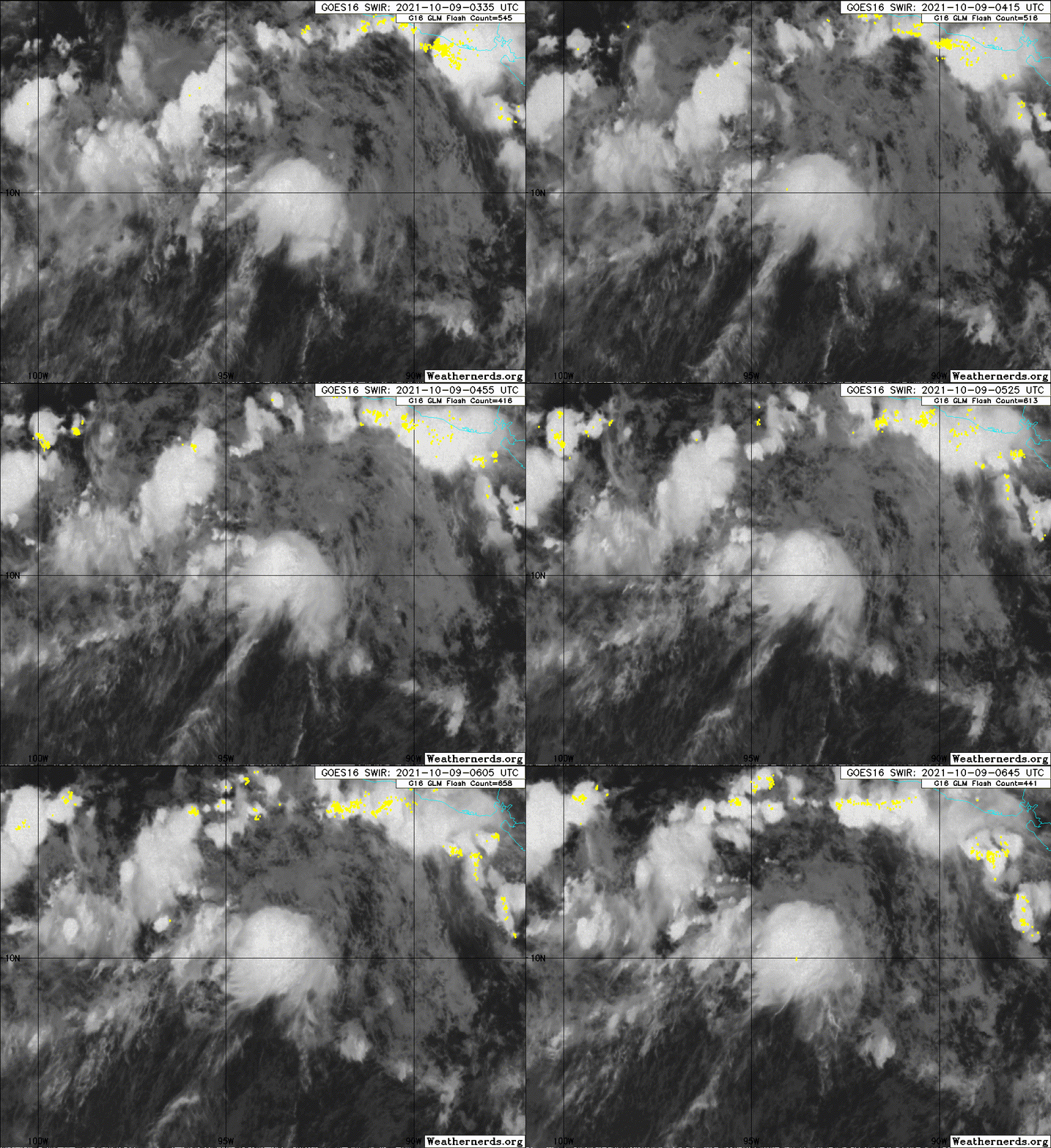
Looks more north-south aligned than yesterday but still very broad. Does not seem to be moving as fast as expected, however, so I guess the GFS will be right in that sense.
3 likes   

User avatar
Yellow Evan
Professional-Met
Professional-Met
Posts: 15952
Age: 25
Joined: Fri Jul 15, 2011 12:48 pm
Location: Henderson, Nevada/Honolulu, HI
Contact:

Re: EPAC: INVEST 91E

#39 Postby Yellow Evan » Sat Oct 09, 2021 8:31 am

1 likes   

zeehag
Tropical Storm
Tropical Storm
Posts: 172
Age: 75
Joined: Sun Jul 17, 2011 9:49 pm
Location: mazatlan,sinaloa, mexico, fixing patricia's mess.
Contact:

Re: EPAC: INVEST 91E

#40 Postby zeehag » Sat Oct 09, 2021 9:16 am

Yellow Evan wrote:
skyline385 wrote:
zeehag wrote:and so we have another letter P for october mayhem. and it seems to be acomin my way yet again. .i can wish it on my friends in barra or i can wish it on my friends in san blas or i can wish it on banderas bay, but this issue will leave a dent. hoping not for a patricia repeat. i havebeen hoping the models i have seen which are way to early and premature are more accurate than not..
seems to be near anniversary of patricias nastiness in barra.. that was an experience.. beautiful storm but wow.

From what i have read, Patricia wasnt that bad at all because of the evacuations and the super rapid weakening because of it's tiny core.


Patricia was no joke at landfall - at 130 knots still the strongest landfall on record on Western Mexico, but it’s saving grace was, much like Monica, that it hit a sparsely populated area.


perula was yes sparsely populated but the wobbly eye and intensification landed squarely on colimilla, where 15 homes lost roofs , some losing all contents of homes, and church went away and church bell blew away--that thing was heavy and old... may have been easy for you and yours but for those if us in colimilla and barra, it was no bludi joke. boat nextto me lost mast. marina electrical boxes were knocked over and cell towers toppled, and so much more damages. faarms disappeared all fruittrees ended up gone complete with fruit which was ready to harvest....
the landfall winds were much easier than the second half winds.. you should have been there,,makes a difference if you are under the storm or not..and the alleged landfall was not only one place was 2..perula got only a small amount..and colimilla got slammed. and talk with the captain of the grain carrier that was driven onto our rock, just the other side of the spine along the peninsula.. he could not see squat and was parked on the beach cracked in half. ship is still there. so tell us again how easy the storm was.
remember those who didnot experience it not to down talk the issue with folks who survived it. puerto vallarta was no where near th4e trajectory of patricia. yet they sound off more than those of us who knew her so well.
AND THERE WAS NO EVACUATION
0 likes   
life is an adventure meant to be LIVED!!!

http://www.sksolitarybird.org


Return to “2021”

Who is online

Users browsing this forum: No registered users and 83 guests