ATL: NICOLE - Models

Moderator: S2k Moderators

Message
Author
User avatar
Blown Away
S2K Supporter
S2K Supporter
Posts: 9867
Joined: Wed May 26, 2004 6:17 am

Re: ATL: INVEST 98L - Models

#101 Postby Blown Away » Sun Nov 06, 2022 8:37 pm

eastcoastFL wrote:
Blown Away wrote:
NDG wrote:A closer look at the latest 0z TVCN consensus model.

https://i.imgur.com/ed8zZG0.gif


18z GFS & EURO are at least 50 miles S at the FL landfall point and they both bury into FL Peninsula compared to the TVCN’s skimming E coast. Unusual to see that big of a spread


Euro is a bit closer to the TVCN - it’s hard for me to tell on the low res but it kinda looks like Ft. pierce and GFS looks like Stuart. The Canadian skews the average making landfall around the space coast


Image

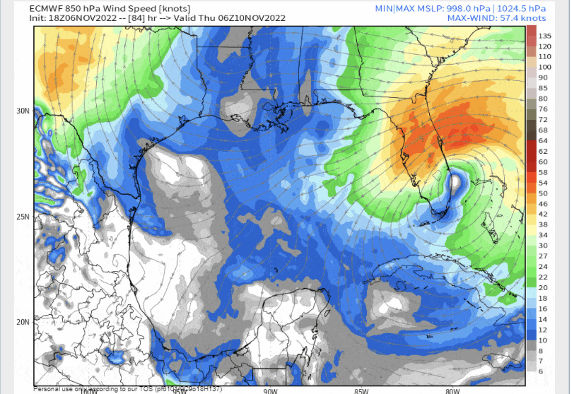
18z Euro landfall @WPB and 00z early TVCN is N of Vero, that’s @70 miles! :double:
3 likes   
Hurricane Eye Experience: David 79, Irene 99, Frances 04, Jeanne 04, Wilma 05... EYE COMING MY WAY IN 2024…
Hurricane Brush Experience: Andrew 92, Erin 95, Floyd 99, Matthew 16, Irma 17, Ian 22, Nicole 22…

User avatar
gatorcane
S2K Supporter
S2K Supporter
Posts: 23499
Age: 46
Joined: Sun Mar 13, 2005 3:54 pm
Location: Boca Raton, FL

Re: ATL: INVEST 98L - Models

#102 Postby gatorcane » Sun Nov 06, 2022 8:41 pm

cycloneye wrote:00z model suite.

https://i.imgur.com/ZmSUkc0.png


Just a couple of shifts away from it recurving just off the FL east coast with no landfall in the US.
1 likes   

User avatar
InfernoFlameCat
Category 5
Category 5
Posts: 1966
Age: 21
Joined: Mon Dec 14, 2020 10:52 am
Location: Buford, GA

Re: ATL: INVEST 98L - Models

#103 Postby InfernoFlameCat » Sun Nov 06, 2022 8:50 pm

gatorcane wrote:
cycloneye wrote:00z model suite.

https://i.imgur.com/ZmSUkc0.png


Just a couple of shifts away from it recurving just off the FL east coast with no landfall in the US.

I believe the TVCN will shift West with the Euro and GFS. It is getting skewed by some other weaker models right now. Granted, the gfs could also be a skew, but I trust it over most other models.
3 likes   
I am by no means a professional. DO NOT look at my forecasts for official information or make decisions based on what I post.

Goal: to become a registered expert over tropical and subtropical cyclones.

Coolcruiseman
Tropical Depression
Tropical Depression
Posts: 71
Age: 50
Joined: Wed Sep 21, 2022 8:10 pm
Location: Melbourne, FL

Re: ATL: INVEST 98L - Models

#104 Postby Coolcruiseman » Sun Nov 06, 2022 8:58 pm

jlauderdal wrote:
NDG wrote:A closer look at the latest 0z TVCN consensus model.

https://i.imgur.com/ed8zZG0.gif

There is your current hurricane center track, they stick to that track as close as they possibly can without going against common sense


Looks to be around Sebastian about 20-30 minutes south of my location. Guess it's time to buckle up.
1 likes   

User avatar
WiscoWx02
Category 1
Category 1
Posts: 341
Age: 21
Joined: Sat Jul 31, 2021 8:09 pm
Location: Minnesota

Re: ATL: INVEST 98L - Models

#105 Postby WiscoWx02 » Sun Nov 06, 2022 9:00 pm

Weakening trend in most of the models as well I've noticed through the day today.
1 likes   

User avatar
ronjon
Category 5
Category 5
Posts: 4671
Joined: Fri Aug 19, 2005 5:17 pm
Location: Hernando Beach, FL

Re: ATL: INVEST 98L - Models

#106 Postby ronjon » Sun Nov 06, 2022 9:03 pm

gatorcane wrote:
cycloneye wrote:00z model suite.

https://i.imgur.com/ZmSUkc0.png


Just a couple of shifts away from it recurving just off the FL east coast with no landfall in the US.


Umm...with the Euro, GFS, and UKMET all pretty close to landfall point on the Florida east coast and them all taking it w-nw across the peninsula to near the Gulf coast, I'd say unlikely at this point. With tomorrow's model runs, we'll be at 72 hours or less to landfall. Should be pretty certain by then if they continue to converge on Stuart-WPB area landfall.
7 likes   

LarryWx
Category 5
Category 5
Posts: 5739
Joined: Sun Sep 07, 2003 2:04 pm
Location: GA

Re: ATL: INVEST 98L - Models

#107 Postby LarryWx » Sun Nov 06, 2022 9:12 pm

Fwiw, the end of the 18Z UKMET (hour 60) is 50 miles NE of the 12Z's hour 66 along with a slightly weaker upper ridge to the NW. This implies to me that the 18Z probably would have landfalled on FL N of the 12Z's Stuart area.
3 likes   
Personal Forecast Disclaimer:
The posts in this forum are NOT official forecasts and should not be used as such. They are just the opinion of the poster and may or may not be backed by sound meteorological data. They are NOT endorsed by any professional institution or storm2k.org. For official information, please refer to the NHC and NWS products.

tolakram
Admin
Admin
Posts: 19171
Age: 60
Joined: Sun Aug 27, 2006 8:23 pm
Location: Florence, KY (name is Mark)

Re: ATL: INVEST 98L - Models

#108 Postby tolakram » Sun Nov 06, 2022 9:27 pm

This is the Euro 0z and 12z trend.
Image

18Z
Image

ICON
Image

GFS
Image

ICON and UKMET are NOT the best models and the NHC has stats to prove it. It pains me to see people come to the models thread and start hugging a model that agrees with their ideas instead of trying to stay objective.
4 likes   
M a r k
- - - - -
Join us in chat: Storm2K Chatroom Invite. Android and IOS apps also available.

The posts in this forum are NOT official forecasts and should not be used as such. Posts are NOT endorsed by any professional institution or STORM2K.org. For official information and forecasts, please refer to NHC and NWS products.

tolakram
Admin
Admin
Posts: 19171
Age: 60
Joined: Sun Aug 27, 2006 8:23 pm
Location: Florence, KY (name is Mark)

Re: ATL: INVEST 98L - Models

#109 Postby tolakram » Sun Nov 06, 2022 9:29 pm

One more, the 0/12Z Euro trend a little later in the run.

Image
0 likes   
M a r k
- - - - -
Join us in chat: Storm2K Chatroom Invite. Android and IOS apps also available.

The posts in this forum are NOT official forecasts and should not be used as such. Posts are NOT endorsed by any professional institution or STORM2K.org. For official information and forecasts, please refer to NHC and NWS products.

User avatar
Blown Away
S2K Supporter
S2K Supporter
Posts: 9867
Joined: Wed May 26, 2004 6:17 am

Re: ATL: INVEST 98L - Models

#110 Postby Blown Away » Sun Nov 06, 2022 9:38 pm

tolakram wrote:

This is the Euro 0z and 12z trend.
https://i.imgur.com/hOfK3Aj.gif

18Z
https://i.imgur.com/1O6RLaQ.png

ICON
https://i.imgur.com/BXnbn6a.gif

GFS
https://i.imgur.com/75Ut7ue.gif

ICON and UKMET are NOT the best models and the NHC has stats to prove it. It pains me to see people come to the models thread and start hugging a model that agrees with their ideas instead of trying to stay objective.


The 00z early TVCN went rogue and shows skimming Central FL coast and a recurve while majority of the 18z globals are well south and WNW into FL Peninsula. That’s the chatter. :D
4 likes   
Hurricane Eye Experience: David 79, Irene 99, Frances 04, Jeanne 04, Wilma 05... EYE COMING MY WAY IN 2024…
Hurricane Brush Experience: Andrew 92, Erin 95, Floyd 99, Matthew 16, Irma 17, Ian 22, Nicole 22…

tolakram
Admin
Admin
Posts: 19171
Age: 60
Joined: Sun Aug 27, 2006 8:23 pm
Location: Florence, KY (name is Mark)

Re: ATL: INVEST 98L - Models

#111 Postby tolakram » Sun Nov 06, 2022 9:39 pm

Here's the latest UKMET run
Image

Here was the UKIE yesterday
Image
1 likes   
M a r k
- - - - -
Join us in chat: Storm2K Chatroom Invite. Android and IOS apps also available.

The posts in this forum are NOT official forecasts and should not be used as such. Posts are NOT endorsed by any professional institution or STORM2K.org. For official information and forecasts, please refer to NHC and NWS products.

User avatar
ThunderForce
Tropical Storm
Tropical Storm
Posts: 158
Age: 25
Joined: Tue Sep 27, 2022 6:20 pm
Location: Florida Panhandle

Re: ATL: INVEST 98L - Models

#112 Postby ThunderForce » Sun Nov 06, 2022 9:58 pm

Pretty weird that the 00z track consensus doesn't seem to match the 18z or 12z operational models for GFS and Euro. The 18z and 12z GFS and 12z Euro feature this storm making it at least near the west coast and Gulf before curving north to north-northeastward.
0 likes   
Please refer to the NWS, NHC, SPC or a professional meteorologist for information and decision making during storms.

AxaltaRacing24
Category 5
Category 5
Posts: 1709
Age: 24
Joined: Wed Jul 27, 2016 11:14 am
Location: Jupiter, FL

Re: ATL: INVEST 98L - Models

#113 Postby AxaltaRacing24 » Sun Nov 06, 2022 10:13 pm

ThunderForce wrote:Pretty weird that the 00z track consensus doesn't seem to match the 18z or 12z operational models for GFS and Euro. The 18z and 12z GFS and 12z Euro feature this storm making it at least near the west coast and Gulf before curving north to north-northeastward.

simple answer, the CMC and ICON.
0 likes   

User avatar
eastcoastFL
Category 5
Category 5
Posts: 3437
Age: 42
Joined: Thu Apr 12, 2007 12:29 pm
Location: Palm City, FL

Re: ATL: INVEST 98L - Models

#114 Postby eastcoastFL » Sun Nov 06, 2022 10:19 pm

I was looking at the HWRF and HMON. Those two still plow right across the state pretty far into the gulf before turning north towards the panhandle and big bend.
0 likes   
Personal Forecast Disclaimer:
The posts in this forum are NOT official forecast and should not be used as such. They are just the opinion of the poster and may or may not be backed by sound meteorological data. They are NOT endorsed by any professional institution or storm2k.org. For official information, please refer to the NHC and NWS products.

Pelicane
Tropical Depression
Tropical Depression
Posts: 51
Joined: Tue Sep 13, 2022 1:52 pm
Location: Lafayette, Louisiana

Re: ATL: INVEST 98L - Models

#115 Postby Pelicane » Sun Nov 06, 2022 10:23 pm

Latest ICON was weaker but trended west. Instead of riding up the coast it travels inland across the peninsula.
0 likes   

LarryWx
Category 5
Category 5
Posts: 5739
Joined: Sun Sep 07, 2003 2:04 pm
Location: GA

Re: ATL: INVEST 98L - Models

#116 Postby LarryWx » Sun Nov 06, 2022 10:23 pm

0Z ICON comes well inland into FL instead of skirting the coast due to stronger ridging to the NW and N.
0 likes   
Personal Forecast Disclaimer:
The posts in this forum are NOT official forecasts and should not be used as such. They are just the opinion of the poster and may or may not be backed by sound meteorological data. They are NOT endorsed by any professional institution or storm2k.org. For official information, please refer to the NHC and NWS products.

User avatar
Spacecoast
Category 2
Category 2
Posts: 687
Joined: Thu Aug 31, 2017 2:03 pm

Re: ATL: INVEST 98L - Models

#117 Postby Spacecoast » Sun Nov 06, 2022 10:27 pm

Isn't the position error (for TVCN,UKM,CEM2,AVNO, ECMO) at 96 hours approx 150 miles?

That's also the width of the FL peninsula, so east coast vs west coast are within a reasonable margin of error as the storm tracks N in four days.
Also, this isn't a straight line forecast track. It's a sideways 'S' track, so they all may have an even higher position error, since 3 'curves' have to be predicted correctly.

Regardless, the impact area is very large, and encompasses most of FL.
4-6" of rain, and Tropical storm force winds (10m) seem likely. Perhaps stronger..
Last edited by Spacecoast on Sun Nov 06, 2022 10:29 pm, edited 1 time in total.
1 likes   

User avatar
chaser1
S2K Supporter
S2K Supporter
Posts: 4717
Age: 63
Joined: Sat Oct 15, 2005 5:59 pm
Location: Longwood, Fl

Re: ATL: INVEST 98L - Models

#118 Postby chaser1 » Sun Nov 06, 2022 10:27 pm

Given the baroclinic type system at hand (as well as further insight to nuanced pattern change over the CONUS), I took a look at the latest 0Z NAM. It's been quite steady and still calling for a 987 storm to come in around Vero around 6Z Thurs
1 likes   
Personal Forecast Disclaimer:
The posts in this forum are NOT official forecast and should not be used as such. They are just the opinion of the poster and may or may not be backed by sound meteorological data. They are NOT endorsed by any professional institution or storm2k.org. For official information, please refer to the NHC and NWS products.


User avatar
Blown Away
S2K Supporter
S2K Supporter
Posts: 9867
Joined: Wed May 26, 2004 6:17 am

Re: ATL: INVEST 98L - Models

#119 Postby Blown Away » Sun Nov 06, 2022 10:28 pm

LarryWx wrote:0Z ICON comes well inland into FL instead of skirting the coast due to stronger ridging to the NW and N.


Image

Big shift W.

Larry noticing many models going over Peninsula are actually dropping in mb, 00z ICON, 18z EURO??
0 likes   
Hurricane Eye Experience: David 79, Irene 99, Frances 04, Jeanne 04, Wilma 05... EYE COMING MY WAY IN 2024…
Hurricane Brush Experience: Andrew 92, Erin 95, Floyd 99, Matthew 16, Irma 17, Ian 22, Nicole 22…

User avatar
SFLcane
S2K Supporter
S2K Supporter
Posts: 9617
Age: 46
Joined: Sat Jun 05, 2010 1:44 pm
Location: Lake Worth Florida

Re: ATL: INVEST 98L - Models

#120 Postby SFLcane » Sun Nov 06, 2022 10:29 pm

Um holy moly… this is Andy’s model which did very well with Ian.

Image
3 likes   


Return to “2022”

Who is online

Users browsing this forum: No registered users and 16 guests