ATL: IAN - Models
Moderator: S2k Moderators
-
cheezyWXguy

- Category 5

- Posts: 6282
- Joined: Mon Feb 13, 2006 12:29 am
- Location: Dallas, TX
Re: ATL: INVEST 98L - Models
GEFS looks like it’s largely clustered near the Sarasota/Tampa area, very near the op. That said, tonight’s model runs basically tell us the whole peninsula is in play. Would expect additional shifts as the system develops, as its track will likely be influenced by how much it strengthens in the next couple of days.
5 likes
Re: ATL: INVEST 98L - Models
GFS, Icon, and CMC spends Wednesday through Friday dumping rain on Florida. So may be a big deal regardless of exactly where landfall happens.
1 likes
Re: ATL: INVEST 98L - Models
cheezyWXguy wrote:GEFS looks like it’s largely clustered near the Sarasota/Tampa area, very near the op. That said, tonight’s model runs basically tell us the whole peninsula is in play. Would expect additional shifts as the system develops, as its track will likely be influenced by how much it strengthens in the next couple of days.
Agreed..I don’t think the shifts are done..I think Euro shifts back west to around where the 12z run was and the GFS will continue trending south is my feeling…
The posts in this forum are NOT official forecasts and should not be used as such. They are just the opinion of the poster and may or may not be backed by sound meteorological data. They are NOT endorsed by any professional institution or STORM2K. For official information, please refer to products from the NHC and NWS.
0 likes

Re: ATL: INVEST 98L - Models
cheezyWXguy wrote:GEFS looks like it’s largely clustered near the Sarasota/Tampa area, very near the op. That said, tonight’s model runs basically tell us the whole peninsula is in play. Would expect additional shifts as the system develops, as its track will likely be influenced by how much it strengthens in the next couple of days.
Just seems like a really tough forecast even beyond the usual concerns. First there is the will it won't it hit Cuba (and for how much will that weaken it), and then the angle of attack on Florida is always tough (like a few hours off in the timing of the turn can mean dozens of miles of change in the landfall), then you have the timing and location of the stall if that happens (what if it stalls just offshore and drifts north - or crosses then drifts north on the east coast).
Lots of variables for a storm that hasnt even formed yet and which will be there in five days or so.
5 likes


Re: ATL: INVEST 98L - Models
tomatkins wrote:MetroMike wrote:CMC rides it up the coast from Ft Myers weakening.
So CMC, GFS, and ICON all show a landfall in Florida followed by a slow northernish motion. Not great.
Just for giggles, throw the NAM in with everyone else.... except it showing an earlier Florida impact with a 12Z Monday position just north of the Cuban coast moving NNW toward the Keys.
1 likes
Andy D
(For official information, please refer to the NHC and NWS products.)
(For official information, please refer to the NHC and NWS products.)
Re: ATL: INVEST 98L - Models
chaser1 wrote:tomatkins wrote:MetroMike wrote:CMC rides it up the coast from Ft Myers weakening.
So CMC, GFS, and ICON all show a landfall in Florida followed by a slow northernish motion. Not great.
Just for giggles, throw the NAM in with everyone else.... except it showing an earlier Florida impact with a 12Z Monday position just north of the Cuban coast moving NNW toward the Keys.
I was looking at that earlier. Maybe similar track to Euro with it missing CONUS or just a near brush with a Cat 1. Would take this sort of solution at this point.
0 likes
-
cheezyWXguy
- Category 5
- Posts: 6282
- Joined: Mon Feb 13, 2006 12:29 am
- Location: Dallas, TX
Re: ATL: INVEST 98L - Models
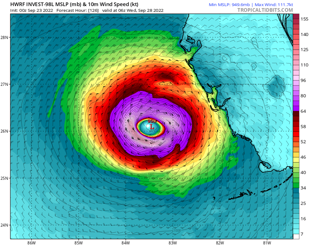
0z HWRF gets it down to 934mb west of Florida, let’s see what the HMON shows next
0 likes
-
skyline385

- Category 5
- Posts: 2728
- Age: 35
- Joined: Wed Aug 26, 2020 11:15 pm
- Location: Houston TX
Re: ATL: INVEST 98L - Models
cheezyWXguy wrote:0z HWRF gets it down to 934mb west of Florida, let’s see what the HMON shows next
Where you seeing that? Cant find a fully loaded HWRF anywhere yet.
0 likes
Re: ATL: INVEST 98L - Models
cheezyWXguy wrote:0z HWRF gets it down to 934mb west of Florida, let’s see what the HMON shows next
I think that’s the 18z run because the 00z run has only gone out to 90 hours..
1 likes
-
cheezyWXguy
- Category 5
- Posts: 6282
- Joined: Mon Feb 13, 2006 12:29 am
- Location: Dallas, TX
Re: ATL: INVEST 98L - Models
skyline385 wrote:cheezyWXguy wrote:0z HWRF gets it down to 934mb west of Florida, let’s see what the HMON shows next
Where you seeing that? Cant find a fully loaded HWRF anywhere yet.
Ah dang must be getting late. That was the 18z. 0z is out to 90 hours and so far is quite a bit weaker
0 likes
-
AutoPenalti
- Category 5
- Posts: 4091
- Age: 29
- Joined: Mon Aug 17, 2015 4:16 pm
- Location: Ft. Lauderdale, Florida
Re: ATL: INVEST 98L - Models
HWRF further south or slower and 20mb weaker
ends roughly the same just 20mb weaker
ends roughly the same just 20mb weaker
0 likes
The posts in this forum are NOT official forecasts and should not be used as such. They are just the opinion of the poster and may or may not be backed by sound meteorological data. They are NOT endorsed by any professional institution or STORM2K. For official information, please refer to products from the NHC and NWS.
Model Runs Cheat Sheet:
GFS (5:30 AM/PM, 11:30 AM/PM)
HWRF, GFDL, UKMET, NAVGEM (6:30-8:00 AM/PM, 12:30-2:00 AM/PM)
ECMWF (1:45 AM/PM)
TCVN is a weighted averaged
-
AutoPenalti
- Category 5
- Posts: 4091
- Age: 29
- Joined: Mon Aug 17, 2015 4:16 pm
- Location: Ft. Lauderdale, Florida
Re: ATL: INVEST 98L - Models
Euro even weaker, not even a tropical storm. 998mb. Further North.
1 likes
The posts in this forum are NOT official forecasts and should not be used as such. They are just the opinion of the poster and may or may not be backed by sound meteorological data. They are NOT endorsed by any professional institution or STORM2K. For official information, please refer to products from the NHC and NWS.
Model Runs Cheat Sheet:
GFS (5:30 AM/PM, 11:30 AM/PM)
HWRF, GFDL, UKMET, NAVGEM (6:30-8:00 AM/PM, 12:30-2:00 AM/PM)
ECMWF (1:45 AM/PM)
TCVN is a weighted averaged

Re: ATL: INVEST 98L - Models
Even 0z HWRF is coming to agreement with 0z GFS, CMC and ICON with the general area. We'll see what happens with 0z Euro, and whether models change again in future runs.
Much weaker than last few runs, but it might be too early to say if it's just a fluke or a trend.
Much weaker than last few runs, but it might be too early to say if it's just a fluke or a trend.
2 likes
TC naming lists: retirements and intensity
Most aggressive Advisory #1's in North Atlantic (cr. kevin for starting the list)
Most aggressive Advisory #1's in North Atlantic (cr. kevin for starting the list)

Re: ATL: INVEST 98L - Models
Teban54 wrote:Even 0z HWRF is coming to agreement with 0z GFS, CMC and ICON with the general area. We'll see what happens with 0z Euro, and whether models change again in future runs.
Much weaker than last few runs, but it might be too early to say if it's just a fluke or a trend.
https://i.postimg.cc/gcfVm2vH/image.png
still a sub 960 storm right off the coast...not great
1 likes
Just like Jon Snow..."I know nothing" except what I know, and most of what I know is gathered by the fine people of the NHC
Re: ATL: INVEST 98L - Models
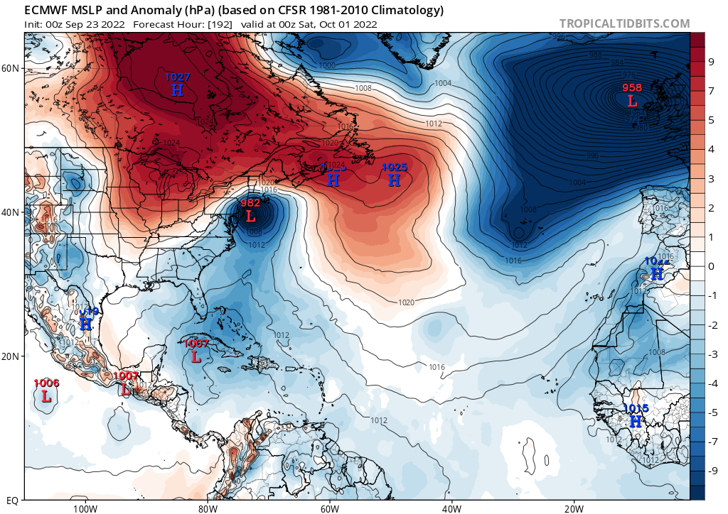
0z euro, very very slight left shift from 12z.

Moves out (doesn't stall like the others)

Moves out (doesn't stall like the others)
Last edited by BobHarlem on Fri Sep 23, 2022 1:31 am, edited 1 time in total.
0 likes
-
AxaltaRacing24
- Category 5
- Posts: 1774
- Age: 25
- Joined: Wed Jul 27, 2016 11:14 am
- Location: Jupiter, FL
Re: ATL: INVEST 98L - Models
BobHarlem wrote:0z euro.
https://i.imgur.com/8B1b7gT.png
Moves out (doesn't stall like the others)
https://i.imgur.com/yeT9UGJ.png
Yeah. Anywhere from the keys to the big bend was in play tonight.
0 likes
-
Bocadude85

- Category 5
- Posts: 2991
- Age: 39
- Joined: Mon Apr 18, 2005 2:20 pm
- Location: Honolulu,Hi
Re: ATL: INVEST 98L - Models
0z Euro brings a strengthening storm through the keys and then NE across SW Florida.
0 likes
Re: ATL: INVEST 98L - Models
Exits Florida here:


Euro is slightly slower than 12z, arrives in SW Florida early Wednesday instead of Tuesday night. And 0z is much closer to Naples than 12z. Exit point on the east is a little further north also. Then clips outer banks quite a bit stronger, and slams into Long island after that.
Euro is slightly slower than 12z, arrives in SW Florida early Wednesday instead of Tuesday night. And 0z is much closer to Naples than 12z. Exit point on the east is a little further north also. Then clips outer banks quite a bit stronger, and slams into Long island after that.
Last edited by BobHarlem on Fri Sep 23, 2022 1:47 am, edited 3 times in total.
0 likes
Re: ATL: INVEST 98L - Models
Friendly reminder of Euro's weak bias and how it can affect track in this case:
https://twitter.com/AndyHazelton/status/1573125286744449024
I really can't see Euro's intensity play out, especially given the organization trends today.
https://twitter.com/AndyHazelton/status/1573125286744449024
I really can't see Euro's intensity play out, especially given the organization trends today.
3 likes
TC naming lists: retirements and intensity
Most aggressive Advisory #1's in North Atlantic (cr. kevin for starting the list)
Most aggressive Advisory #1's in North Atlantic (cr. kevin for starting the list)
Re: ATL: INVEST 98L - Models
Meanwhile, Euro wants a Long Island Express.
0 likes
TC naming lists: retirements and intensity
Most aggressive Advisory #1's in North Atlantic (cr. kevin for starting the list)
Most aggressive Advisory #1's in North Atlantic (cr. kevin for starting the list)
Who is online
Users browsing this forum: No registered users and 30 guests