ATL: FIONA - Models
Moderator: S2k Moderators
-
SFLcane

- S2K Supporter

- Posts: 10281
- Age: 48
- Joined: Sat Jun 05, 2010 1:44 pm
- Location: Lake Worth Florida
Re: ATL: SEVEN - Models
Find those bending westward eps members rather interesting in the bahamas.
0 likes
-
LadyBug72

- Tropical Storm

- Posts: 121
- Joined: Mon Jun 01, 2020 3:39 pm
- Location: about 20 miles from Galveston, Tx
Re: ATL: SEVEN - Models
Hammy wrote:So the Euro with a general left/west bias recurves early, GFS with a recurve bias goes up the coast, and Canadian with a general east/right bias goes into the Gulf
And here we are stuck in the middle!

0 likes
Formerly known as the user: Nikki
Alicia 83, Allison 01, Rita 05, Ike 08, Harvey 17, Nicholas 21, Coastal Texas Derecho 24, Beryl 24
Alicia 83, Allison 01, Rita 05, Ike 08, Harvey 17, Nicholas 21, Coastal Texas Derecho 24, Beryl 24


Re: ATL: SEVEN - Models
Still a long way to go with this one. Those westward bends could be trouble.
0 likes
-
Emmett_Brown

- Category 5

- Posts: 1433
- Joined: Wed Aug 24, 2005 9:10 pm
- Location: Sarasota FL
Re: ATL: SEVEN - Models
The 12Z GFS and 12Z Euro take a powerful typhoon Merbok into the Bearing Sea between Alaska and Russia by 18Z Friday as a sub 945mb low, which is a very powerful storm for this time of year in the Bearing sea. The GFS and Euro seem to agree on Merbok's strength and speed of motion through the next 100 hours, and their upper air pattern looks pretty similar. But, the GFS is a lot slower with the motion of TD7 than the Euro. It will be interesting to see if Merbok actually get's that strong as an extratropical low, and if this would change the downstream pattern if it doesn't verify.
0 likes
-
Blown Away

- S2K Supporter
- Posts: 10253
- Joined: Wed May 26, 2004 6:17 am
Re: ATL: SEVEN - Models

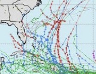
12z EPS.
Seems if TD7 deepens below @980 mb before @70W the trough will catch TD7 and push N. If TD7 remains somewhat shallow >980 mb past 70W when it moves off Hispaniola/Cuba the building high pressure may block TD7 into Bahamas, FL, GOM or mid Atlantic? If the second scenario plays out when TD or TS moves off Cuba/Hispaniola, lots of blues/reds indicating a very good environment for strengthening under the high pressure. JMHO
0 likes
Hurricane Eye Experience: David 79, Irene 99, Frances 04, Jeanne 04, Wilma 05… Hurricane Brush Experience: Andrew 92, Erin 95, Floyd 99, Matthew 16, Irma 17, Ian 22, Nicole 22…
-
tolakram
- Admin

- Posts: 20186
- Age: 62
- Joined: Sun Aug 27, 2006 8:23 pm
- Location: Florence, KY (name is Mark)
Re: ATL: SEVEN - Models
12Z Euro run

1 likes
M a r k
- - - - -
Join us in chat: Storm2K Chatroom Invite. Android and IOS apps also available.
The posts in this forum are NOT official forecasts and should not be used as such. Posts are NOT endorsed by any professional institution or STORM2K.org. For official information and forecasts, please refer to NHC and NWS products.
-
AtlanticWind
- S2K Supporter
- Posts: 1898
- Age: 67
- Joined: Sun Aug 08, 2004 9:57 pm
- Location: Plantation,Fla
Re: ATL: SEVEN - Models
AtlanticWind wrote:Gfs 18z a little south and faster
Yeah up to 138 hrs and the system is significantly south of the 12z GFS and 12z Euro
0 likes
-
tolakram
- Admin
- Posts: 20186
- Age: 62
- Joined: Sun Aug 27, 2006 8:23 pm
- Location: Florence, KY (name is Mark)
Re: ATL: SEVEN - Models
The solution looks very similar to euro, timing aside.

0 likes
M a r k
- - - - -
Join us in chat: Storm2K Chatroom Invite. Android and IOS apps also available.
The posts in this forum are NOT official forecasts and should not be used as such. Posts are NOT endorsed by any professional institution or STORM2K.org. For official information and forecasts, please refer to NHC and NWS products.
- - - - -
Join us in chat: Storm2K Chatroom Invite. Android and IOS apps also available.
The posts in this forum are NOT official forecasts and should not be used as such. Posts are NOT endorsed by any professional institution or STORM2K.org. For official information and forecasts, please refer to NHC and NWS products.
Re: ATL: SEVEN - Models
So far the 18z track on the GFS is more similar to the 6z than 12z, but stronger than 6z.
0 likes
-
Blown Away
- S2K Supporter
- Posts: 10253
- Joined: Wed May 26, 2004 6:17 am
Re: ATL: SEVEN - Models
tolakram wrote:The solution looks very similar to euro, timing aside.
https://i.imgur.com/5uwezyn.png
GFS big SW shift at @162 hours and still quite a bit slower than Euro. Amazing how Hispaniola just devours tropical systems.
0 likes
Hurricane Eye Experience: David 79, Irene 99, Frances 04, Jeanne 04, Wilma 05… Hurricane Brush Experience: Andrew 92, Erin 95, Floyd 99, Matthew 16, Irma 17, Ian 22, Nicole 22…

Re: ATL: SEVEN - Models
Blown Away wrote:https://i.imgur.com/xD2jzrg.jpg
12z EPS.
Seems if TD7 deepens below @980 mb before @70W the trough will catch TD7 and push N. If TD7 remains somewhat shallow >980 mb past 70W when it moves off Hispaniola/Cuba the building high pressure may block TD7 into Bahamas, FL, GOM or mid Atlantic? If the second scenario plays out when TD or TS moves off Cuba/Hispaniola, lots of blues/reds indicating a very good environment for strengthening under the high pressure. JMHO
There is a recon flight scheduled for early tomorrow afternoon eastern time.
Radiosondes will have clear data about things like humidity and shear for all the different column levels.
Models should start to agree a little better once they get a better grip on the potential.
0 likes
-
gatorcane

- S2K Supporter
- Posts: 23708
- Age: 48
- Joined: Sun Mar 13, 2005 3:54 pm
- Location: Boca Raton, FL
Re: ATL: SEVEN - Models
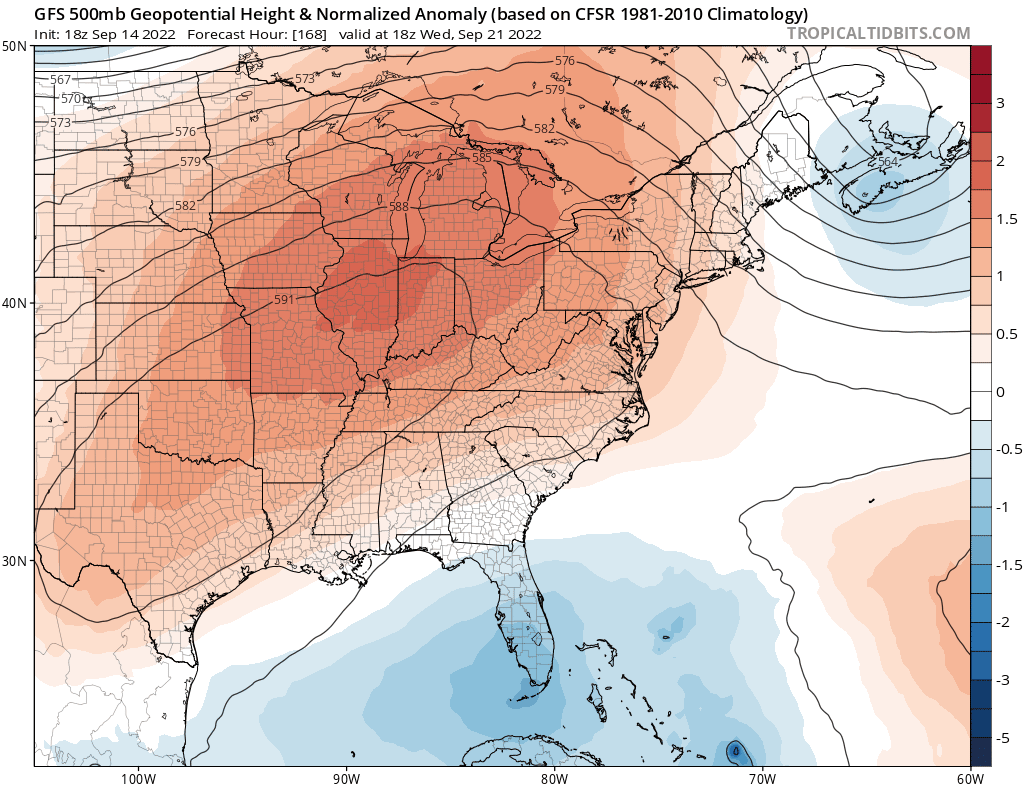
The GFS shows a clear weakness over Florida and the SW Atlantic with the Bermuda High shunted east. So the storms turns north over the Eastern Bahamas. The forecast is similar to the Euro.
0 likes
Re: ATL: SEVEN - Models
gatorcane wrote:The GFS shows a clear weakness over Florida and the SW Atlantic with the Bermuda High shunted east. So the storms turns north over the Eastern Bahamas. The forecast is similar to the Euro.
This does not have the look of a recurve.
1 likes
-
Blown Away
- S2K Supporter
- Posts: 10253
- Joined: Wed May 26, 2004 6:17 am
Re: ATL: SEVEN - Models
gatorcane wrote:The GFS shows a clear weakness over Florida and the SW Atlantic with the Bermuda High shunted east. So the storms turns north over the Eastern Bahamas. The forecast is similar to the Euro.
So far it seems after impacting the GA's TD7 will go N, but there was @300 mile shift W in the 18z at @192 hours.
0 likes
Hurricane Eye Experience: David 79, Irene 99, Frances 04, Jeanne 04, Wilma 05… Hurricane Brush Experience: Andrew 92, Erin 95, Floyd 99, Matthew 16, Irma 17, Ian 22, Nicole 22…
-
Blown Away
- S2K Supporter
- Posts: 10253
- Joined: Wed May 26, 2004 6:17 am
Re: ATL: SEVEN - Models
No slam dunk OTS look from there.
2 likes
Hurricane Eye Experience: David 79, Irene 99, Frances 04, Jeanne 04, Wilma 05… Hurricane Brush Experience: Andrew 92, Erin 95, Floyd 99, Matthew 16, Irma 17, Ian 22, Nicole 22…
Re: ATL: SEVEN - Models
Blown Away wrote:
No slam dunk OTS look from there.
Combined with the fact that this is 10 days out... still in dartboard territory
2 likes
Re: ATL: SEVEN - Models
18Z GFS Manages to clip the northeast part of Nova Scotia near Louisbourg and gets over eastern Newfoundland still fairly formidable. but otherwise stays offshore once past the eastern Bahamas.
0 likes
Who is online
Users browsing this forum: No registered users and 43 guests